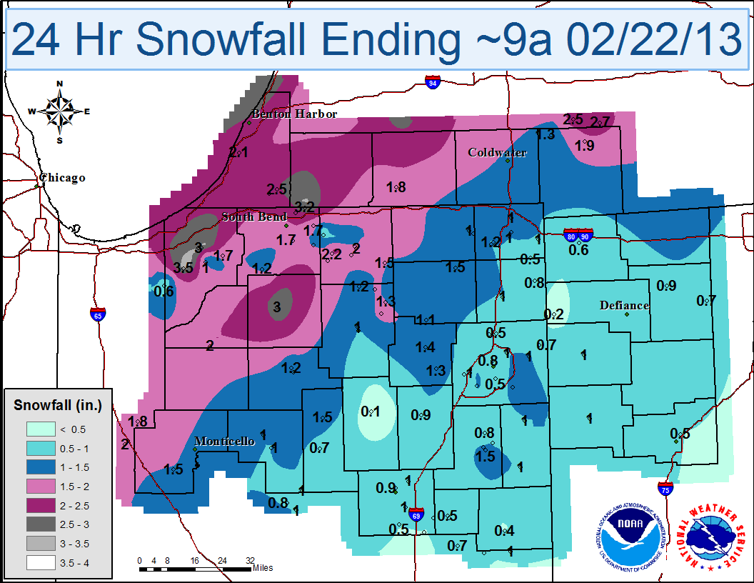
A strong winter storm system moved from the Plains into the Midwest overnight on February 21st into the daylight hours on February 22nd. With subfreezing temperatures, freezing rain and at times sleet, mixed in with snow to create hazardous travel conditions across the local area. Snowfall totals across the area were generally in the 1 to 3 inch range, with ice accumulations of 0.10 inch or less. Thunder and lightning were also reported during the early morning hours in several locations due to the powerful dynamics of the storm system!
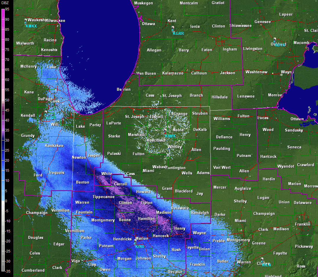
Click on the image below for a radar loop of base reflectivity (0.5 deg) during the storm. The loop is from approximately 1-8 am EST on February 22nd, during which the heaviest precipitation fell.
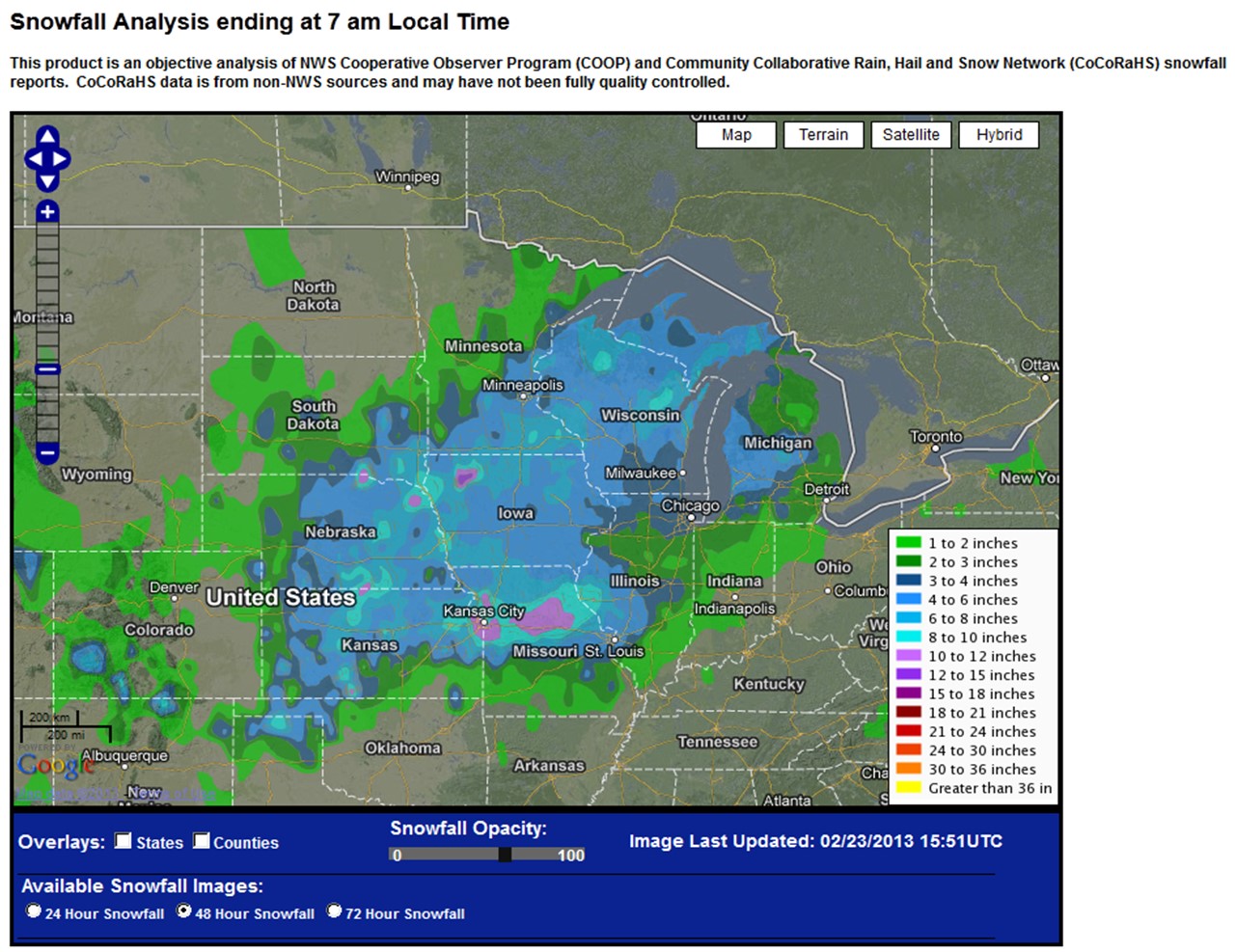
The image below shows storm total snowfall as the storm moved from the central Plains into the Midwest.
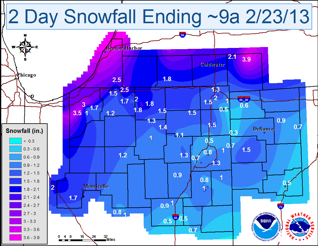
The maps and table below show storm total and daily snowfall from CoCoRaHS, NWS cooperative observers, and official NWS observations ending at approximately 9 am EST on February 23rd. Click on the thumbnails to view larger images.
|
|
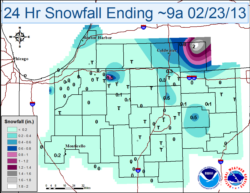 |
| 24 hour Snowfall Ending ~9a 2/22/13 | 24 hour Snowfall Ending ~9a 2/23/13 |
| LOCATION | STORM TOTAL SNOWFALL (IN) |
| Jonesville 5.9 ENE | 3.9 |
| Westville 4.7 ESE | 3.5 |
| La Porte 1.3 SSW | 3.2 |
| La Porte 1.7 SW | 3 |
| Niles 2.7 W | 2.5 |
| Wakarusa 2.4 NNE | 2.3 |
| Buchanan 1.4 ESE | 2.3 |
| Litchfield 0.3 ENE | 2.1 |
| ANGOLA | 2 |
| Elkhart 4.8 SW | 2 |
| Goshen 3.0 WSW | 1.9 |
| Wakarusa 0.3 WSW | 1.8 |
| Goshen 1.9 NW | 1.8 |
| Constantine 1.9 E | 1.8 |
| CHALMERS 5 W | 1.7 |
| Kingsbury 5.0 ENE | 1.7 |
| Mishawaka 3.9 ENE | 1.7 |
| South Bend 4.6 SE | 1.7 |
| Auburn 0.8 NE | 1.5 |
| Millersburg 0.5 SW | 1.5 |
| Kendallville 4.5 NW | 1.5 |
| Hudson 4.6 N | 1.5 |
| Bluffton 0.9 SE | 1.5 |
| PAULDING | 1.5 |
| SOUTH BEND ASOS | 1.5 |
| North Webster 2.3 N | 1.4 |
| Fort Wayne 9.1 SE | 1.3 |
| Milford 0.9 N | 1.3 |
| Mishawaka 5.9 SE | 1.3 |
| Angola 4.1 N | 1.3 |
| Columbia City 6.6 SSE | 1.3 |
| Rochester 2.4 NW | 1.2 |
| Walkerton 5.7 ENE | 1.2 |
| Hudson 4.1 NNW | 1.2 |
| FORT WAYNE ASOS | 1.1 |
| Columbia City 8.4 N | 1.1 |
| BLUFFTON 1 N | 1 |
| DECATUR 1 N | 1 |
| Woodburn 2.8 WSW | 1 |
| Flora 0.3 S | 1 |
| Marion 5.6 NE | 1 |
| Warsaw 1.1 NNW | 1 |
| Angola 1.2 S | 1 |
| Angola 8.7 ESE | 1 |
| KINGSBURY 1 N | 1 |
| Huntington 0.3 W | 0.9 |
| MARION 2 N | 0.9 |
| Napoleon 0.3 NNW | 0.9 |
| Fort Wayne 2.6 NE | 0.8 |
| Bluffton 4.1 N | 0.8 |
| Fort Wayne 7.1 WSW | 0.7 |
| Bluffton 3.0 ENE | 0.7 |
| McClure 3.4 SSE | 0.7 |
| Woodburn 3 N | 0.7 |
| MONTPELIER 0.6 NW | 0.6 |
| Fort Wayne 9.9 NNE | 0.5 |
| Shamrock Lakes 3.0 NNW | 0.5 |
| Fairmount 0.5 NE | 0.5 |
| Hamilton 1.7 E | 0.5 |
| Atlanta 4.1 ENE | 0.5 |
| Lima 2.7 NE | 0.5 |
| HICKSVILLE | 0.3 |
Updated 2/23/2013 11am
CEO