Overview
***Updated to add 4th tornado***
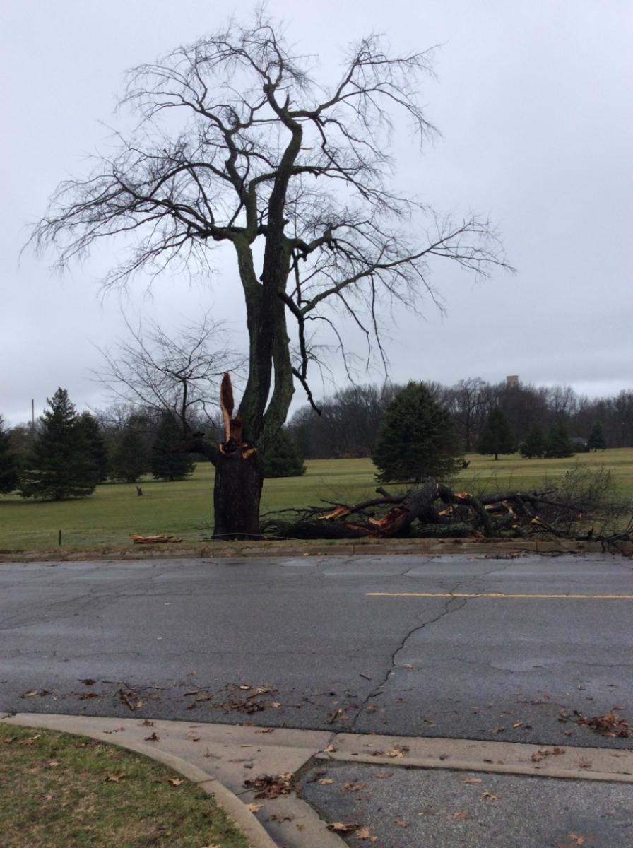
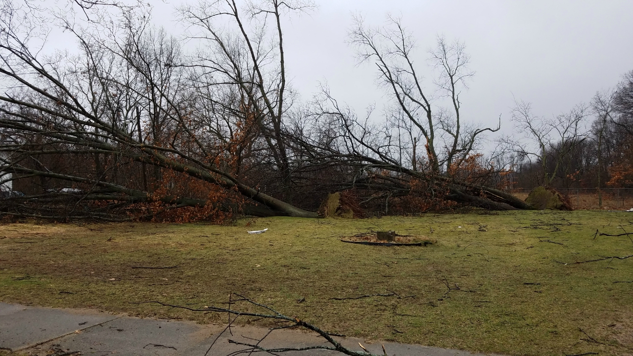
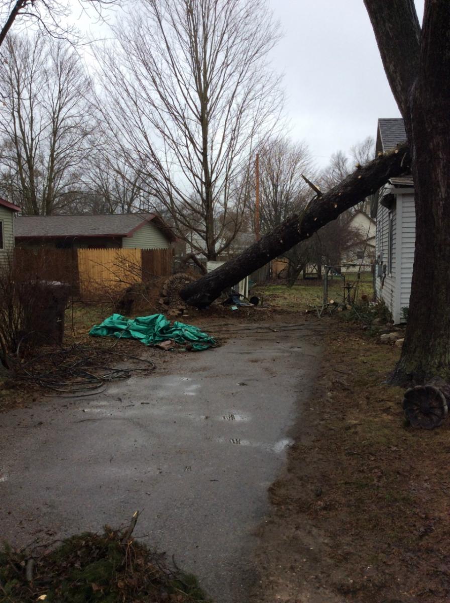
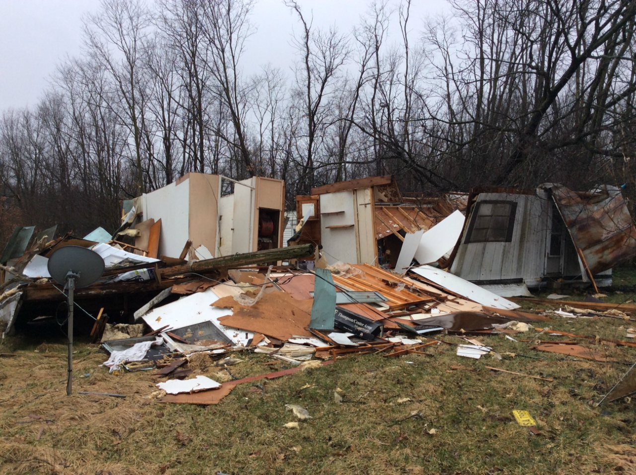
Low pressure deepened northeast into the Great Lakes region late February 28th into early March 1st, 2017. Strong deep layer forcing with this feature and the overspreading of leading (unstable) warm sector forced several episodes of strong to severe convection during this time. The first line segment impacted areas along and north of the toll road in Indiana and Lower Michigan during the early evening produced pockets of large hail and damaging winds. There were also 4 EF1 tornadoes surveyed across Berrien, Cass and St. Joseph Counties in Michigan. A second line of storms moved through the rest of northern Indiana and portions of northwest Ohio during the early morning hours of March 1st. There were numerous hail and damaging wind reports with this line, especially across northeast Indiana with a more pronounced bowing segment.
Tornadoes
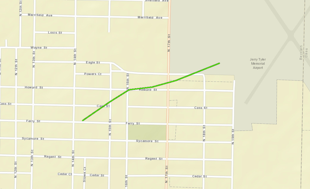
Tornado 1 - Niles, MI
Berrien County
|
||||||||||||||||
|
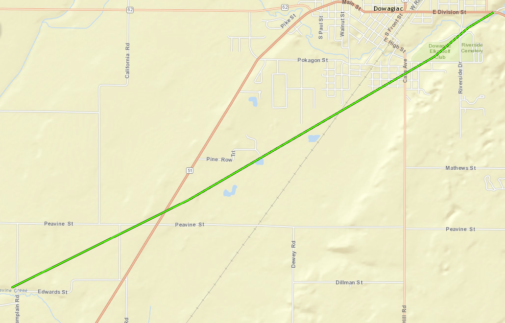
Tornado 2 - Dowagiac, MI
|
||||||||||||||||
|
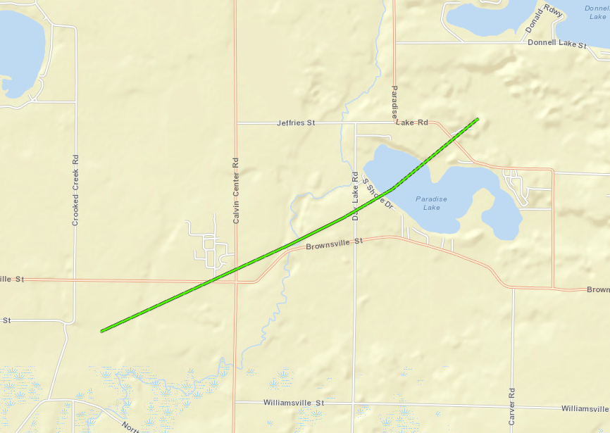
Tornado 3 - Vandalia, MI
|
||||||||||||||||
|
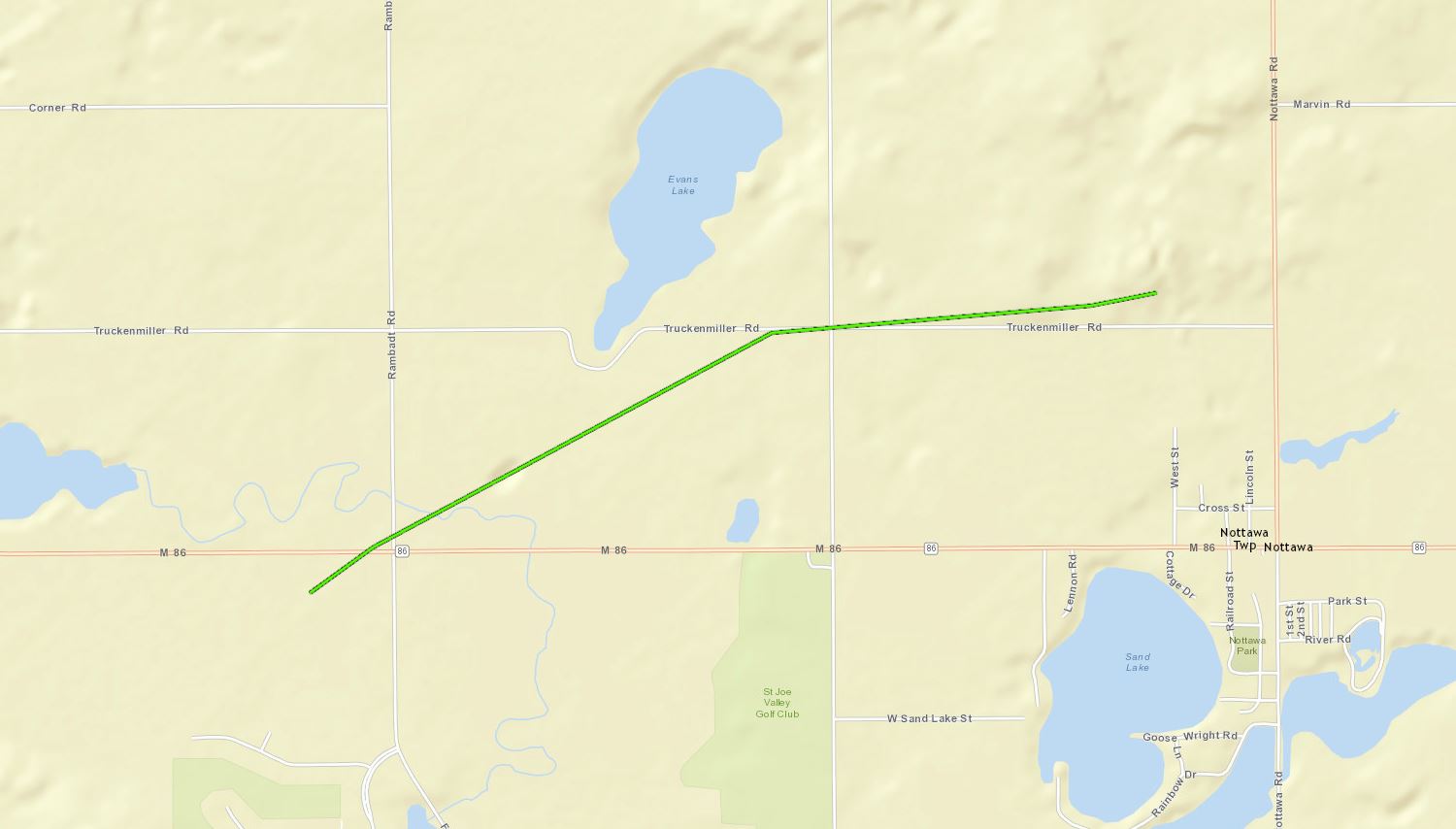
Tornado 4 - Centreville, MI
|
||||||||||||||||
| EF0 Weak 65-85 mph |
EF1 Moderate 86-110 mph |
EF2 Significant 111-135 mph |
EF3 Severe 136-165 mph |
EF4 Extreme 166-200 mph |
EF5 Catastrophic 200+ mph |
 |
|||||
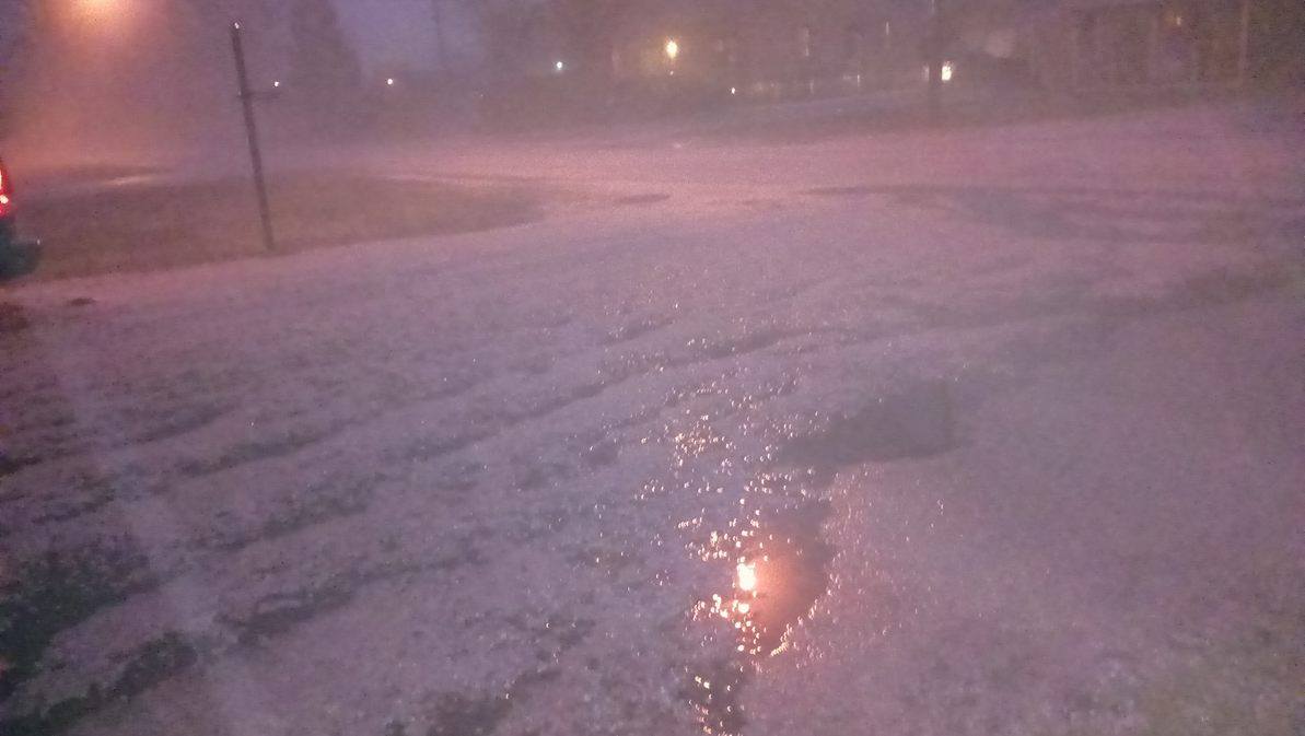
Wind & Hail:
Wind
Two separate convective line segments produced damaging winds in some areas thanks to wind gusts in excess of 60 mph. The first moved through far northern Indiana and southwest Lower Michigan during the evening hours of February 28th, with the second line of storms impacting northeast Indiana and portions of northwest Ohio during the early morning hours of March 1st.
 |
 |
 |
 |
|
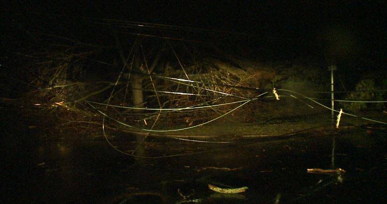
Wind Damage in St. Joseph County Michigan (T.J. Baker) |
Wind Damage in Niles (ABC 57) |
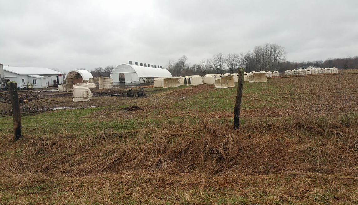
Calf hutches were carried far into the field across the road at this Lagrange County farm (Yoder) |
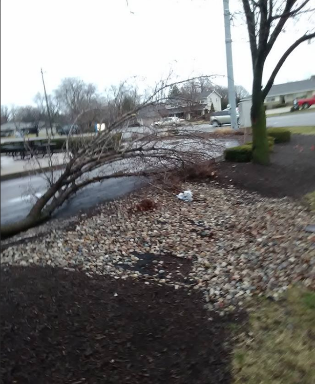
Tree Damage off of Coldwater Road in Fort Wayne, IN (Wesley Pollard) |
Hail
Two separate convective line segments produced large hail in some areas late February 28th into early March 1st. The first moved through far northern Indiana and southwest Lower Michigan during the evening hours of February 28th, with the second line of storms impacting northeast Indiana and portions of northwest Ohio during the early morning hours of March 1st.
 |
 |
.jpg) |
 |
|
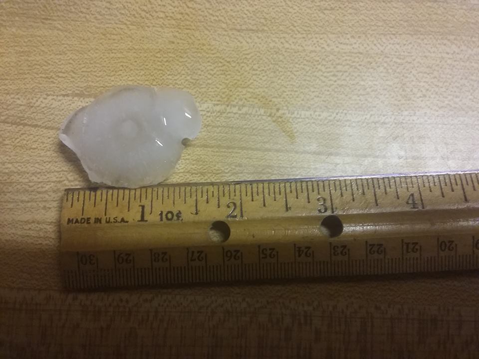
1.25" Diameter Hail Angola, IN (Eric Anthony) |
Large Hail Hudson, IN (Holly Pocock Stewart) |
Hail Covers Ground Fort Wayne, IN (WANE TV) |
Heavy Rain & Hail Fort Wayne, IN (WANE TV) |
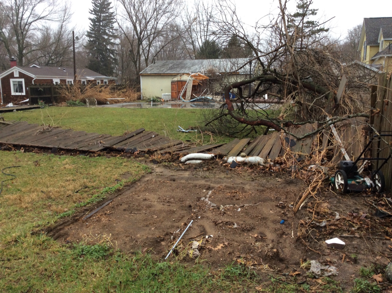
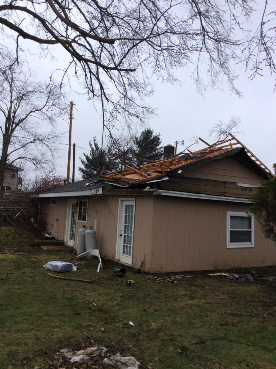
Tornado 1 - Niles, MI
An EF-1 tornado was confirmed in Niles. Below are damage survey pictures from that tornado.
 |
 |
 |
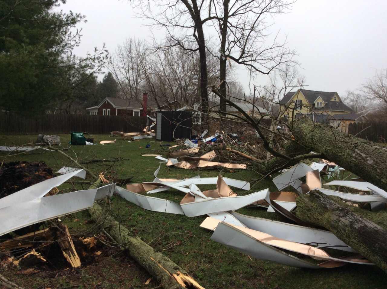 |
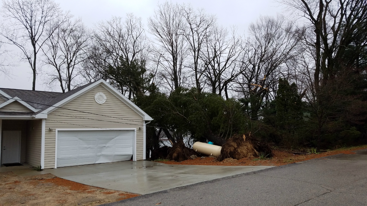
Tornado 2 - Dowagiac, MI
An EF-1 tornado was confirmed in Dogwagiac. Below are damage survey pictures from that tornado.
 |
 |
 |
 |
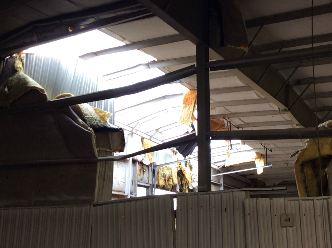
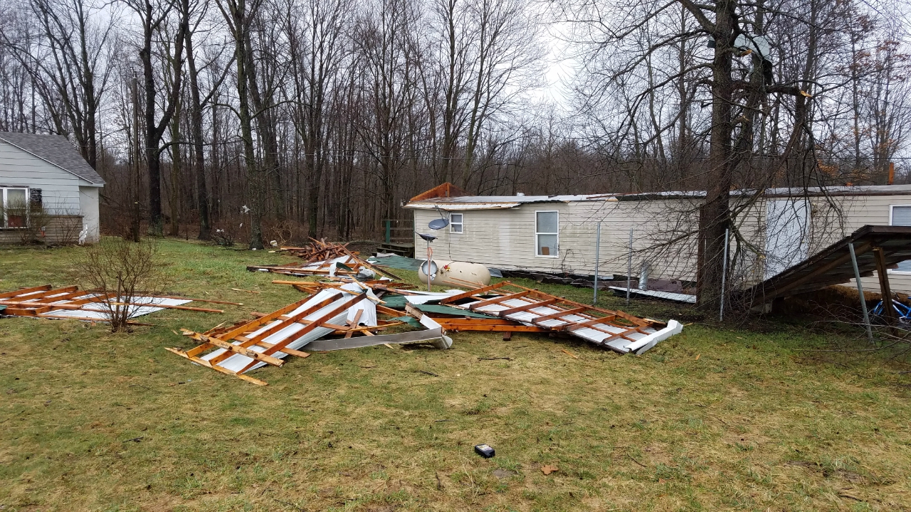
Tornado 3 - South of Vandalia, MI
An EF-1 tornado was confirmed south of Vandalia. Below are damage survey pictures from that tornado.
 |
 |
 |
 |
Flooding & Rainfall
Rainfall: Many areas received an inch or more of rainfall. Below are the reports we received as of 8 am ET from our CoCoRaHs and COOP observers.
Public Information Statement
National Weather Service Northern Indiana
801 AM EST Wed Mar 1 2017

...Rainfall Reports...

Location                     Amount    Time/Date       Lat/Lon

...Indiana...

...Allen County...
2 W Woodburn                 0.91 in   0700 AM 03/01   41.12N/84.91W
2 NE Fort Wayne              0.83 in   0730 AM 03/01   41.10N/85.11W
Woodburn 3N                  0.71 in   0700 AM 03/01   41.16N/84.85W

...Elkhart County...
3 NE Osceola                 2.37 in   0730 AM 03/01   41.71N/86.04W
1 ENE Elkhart                1.52 in   0741 AM 03/01   41.69N/85.94W
1 WNW Jimtown                1.21 in   0600 AM 03/01   41.64N/86.04W
Elkhart Public Works         1.02 in   1200 AM 03/01   41.68N/86.00W

...Huntington County...
Huntington                   0.88 in   0530 AM 03/01   40.86N/85.50W
3 SSW Huntington             0.82 in   0748 AM 03/01   40.83N/85.53W
Huntington                   0.71 in   0700 AM 03/01   40.88N/85.51W

...Kosciusko County...
Leesburg                     0.81 in   0620 AM 03/01   41.33N/85.85W
1 E Claypool                 0.78 in   0650 AM 03/01   41.13N/85.86W

...La Porte County...
Laporte                      1.70 in   0100 AM 03/01   41.61N/86.73W
LaPorte                      1.06 in   0655 AM 03/01   41.57N/86.73W
Kingsbury 1N                 0.73 in   0730 AM 03/01   41.54N/86.70W

...Lagrange County...
2 E Brushy Prairie           1.04 in   0700 AM 03/01   41.64N/85.20W

...Marshall County...
Bourbon 0.4 S                0.88 in   0600 AM 03/01   41.29N/86.12W
Plymouth                     0.78 in   0749 AM 03/01   41.34N/86.31W

...Noble County...
2 E Rome City                0.82 in   0700 AM 03/01   41.50N/85.31W
Kendallville                 0.76 in   0700 AM 03/01   41.44N/85.26W

...St. Joseph County...
South Bend WWTP              2.28 in   0500 AM 03/01   41.72N/86.27W
1 ENE Granger                2.28 in   0700 AM 03/01   41.75N/86.11W
South Bend International Ap  2.15 in   0654 AM 03/01   41.71N/86.32W
1 ESE Indian Village         1.98 in   0700 AM 03/01   41.70N/86.21W
2 S New Carlisle             1.91 in   0746 AM 03/01   41.66N/86.51W
1 NE South Bend              1.84 in   0743 AM 03/01   41.69N/86.25W
2 ESE Mishawaka              1.42 in   0744 AM 03/01   41.65N/86.13W
South Bend                   1.31 in   1200 AM 03/01   41.70N/86.25W
1 ENE Gulivoire Park         1.12 in   0600 AM 03/01   41.62N/86.22W


...Steuben County...
Angola                       1.13 in   0700 AM 03/01   41.64N/84.99W
2 W Silver Lake              0.98 in   0715 AM 03/01   41.63N/85.11W
1 SE Crooked Lake            0.94 in   0748 AM 03/01   41.66N/85.02W
2 ENE Crooked Lake           0.91 in   0545 AM 03/01   41.70N/84.99W
1 E Hamilton                 0.79 in   0700 AM 03/01   41.53N/84.89W
2 WSW Golden Lake            0.76 in   0600 AM 03/01   41.59N/85.10W
1 S Angola                   0.70 in   0600 AM 03/01   41.62N/85.00W

...Whitley County...
1 ENE Peabody                0.71 in   0600 AM 03/01   41.09N/85.47W

...Michigan...

...Berrien County...
1 SE Stevensville            1.48 in   0700 AM 03/01   41.99N/86.51W
Benton Harbor SW Regional    0.99 in   0653 AM 03/01   42.13N/86.43W
2 E Shoreham                 0.93 in   0740 AM 03/01   42.05N/86.47W
Saint Joseph                 0.91 in   0745 AM 03/01   42.10N/86.49W

...Branch County...
Coldwater St School          1.16 in   1200 AM 03/01   41.96N/84.99W

...Cass County...
Barron Lake                  2.37 in   0600 AM 03/01   41.84N/86.18W
2 NW Granger                 2.23 in   0746 AM 03/01   41.77N/86.17W

...Hillsdale County...
Litchfield                   1.65 in   0630 AM 03/01   42.05N/84.75W
Jerome                       1.48 in   0742 AM 03/01   42.02N/84.46W

...St. Joseph County...
Three Rivers                 2.00 in   0700 AM 03/01   41.93N/85.63W
Sturgis                      1.66 in   0655 AM 03/01   41.81N/85.44W

...Ohio...

...Paulding County...
2 W Paulding                 0.73 in   0744 AM 03/01   41.14N/84.64W

Observations are collected from a variety of sources with varying
equipment and exposures. Not all data listed are considered official.
Flash Flood & River Flooding
Because of the rainfall amounts across the area, some of the rivers are forecast to go into flood. Hydrographs showing the river stages are available on our webpage anytime on our AHPS page.
Radar:
You can see the various circulations (indicated by red and green next to each other) in the images below. What's the difference between straight-line winds and tornadoes? Read about it here. For more information about identifying tornadoes visit our MetEd spotter training course.
 |
 |
 |
 |
|
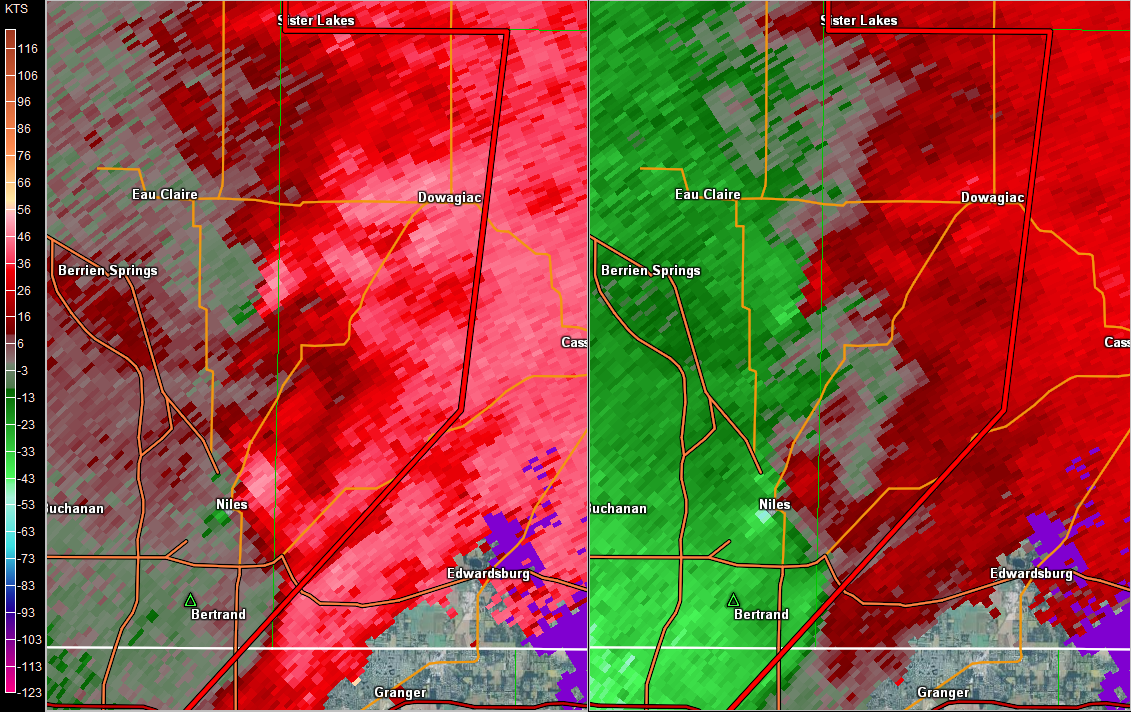
Figure 1: 8:54 pm 2/28/17 Circulations at Niles and approaching Dowagiac. EF1 Tornado confirmed. 0.5 SRM Left, 0.5 V Right |
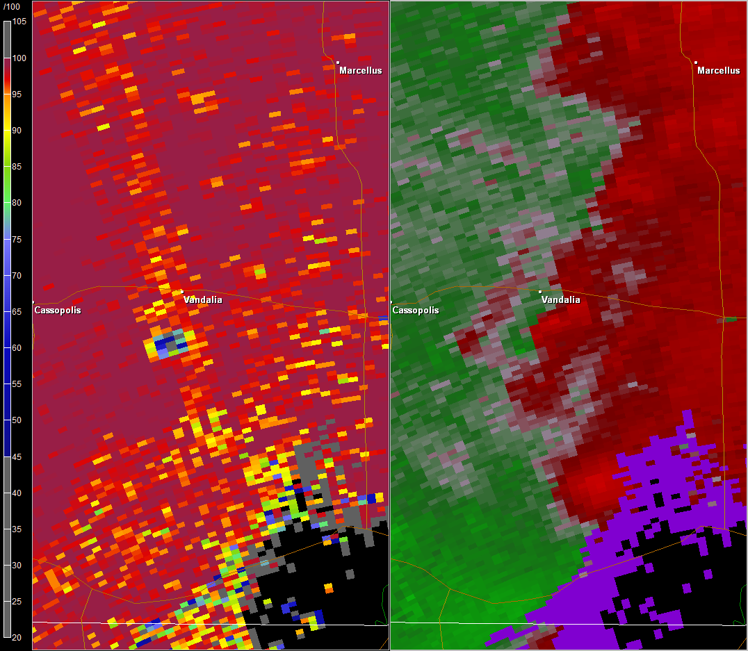
Figure 2: 9:13 pm 2/28/17 Circulation just southwest of Vandalia with a well-defined debris ball. EF1 Tornado confirmed. 0.5 CC Left, 0.5 V Right |
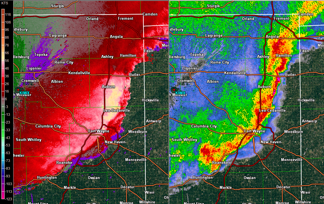
Figure 3: 2:31 am 3/1/17 Damaging Winds with bowing line segment into Allen/Dekalb Counties IN 0.5 Z Left, 0.5 V Right |
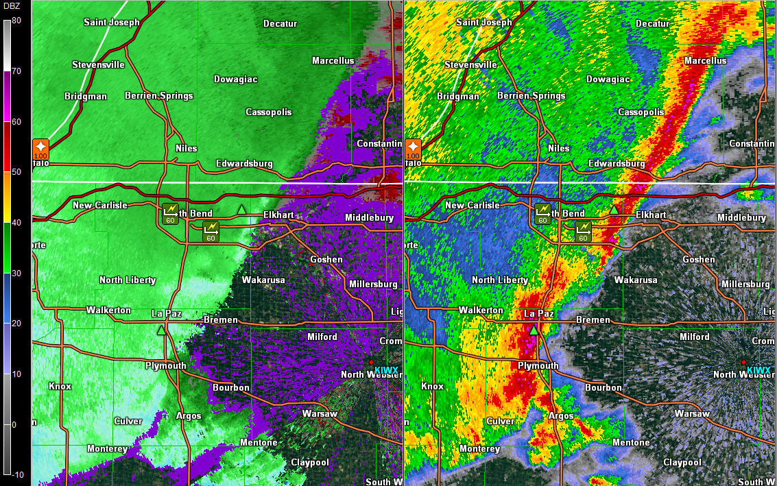
Figure 4: 1:29 am 3/1/17 Round 2 of damaging winds >60 and hail in South Bend/Elkhart/Goshen 0.5Z Left, 0.5 V Right |
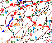
Storm Reports
PRELIMINARY LOCAL STORM REPORT...SUMMARY
NATIONAL WEATHER SERVICE NORTHERN INDIANA
425 AM EST WED MAR 1 2017

..TIME...   ...EVENT...      ...CITY LOCATION...     ...LAT.LON...
..DATE...   ....MAG....      ..COUNTY LOCATION..ST.. ...SOURCE....
            ..REMARKS..

0350 AM     HAIL             COLUMBUS GROVE          40.93N 84.06W
03/01/2017  U0.75 INCH       PUTNAM             OH   PUBLIC


0240 AM     TSTM WND GST     1 SSE WALLEN            41.14N 85.15W
03/01/2017  M71 MPH          ALLEN              IN   AWOS


0240 AM     TSTM WND DMG     3 N GRABILL             41.25N 84.96W
03/01/2017                   ALLEN              IN   AMATEUR RADIO

            SEVERAL TREES DOWNED.

0237 AM     TSTM WND DMG     3 SE WALLEN             41.12N 85.13W
03/01/2017                   ALLEN              IN   PUBLIC

            PINE TREE DOWNED.

0234 AM     TSTM WND DMG     3 N LEO-CEDARVILLE      41.26N 85.02W
03/01/2017                   ALLEN              IN   AMATEUR RADIO

            POWER LINES DOWN.

0234 AM     TSTM WND DMG     3 NNW LEO-CEDARVILLE    41.26N 85.04W
03/01/2017                   ALLEN              IN   AMATEUR RADIO

            TREE ON HOUSE.

0234 AM     TSTM WND DMG     2 NNW LEO-CEDARVILLE    41.24N 85.04W
03/01/2017                   ALLEN              IN   AMATEUR RADIO

            TREE DOWN.

0232 AM     TSTM WND DMG     WALLEN                  41.16N 85.17W
03/01/2017                   ALLEN              IN   PUBLIC

            PORTION OF ROOF BLOWN OFF.

0229 AM     TSTM WND DMG     2 E HUNTERTOWN          41.24N 85.13W
03/01/2017                   ALLEN              IN   PUBLIC

            LARGE TREE DOWN ON ROAD.

0227 AM     TSTM WND GST     1 NNW GARRETT           41.37N 85.14W
03/01/2017  E60 MPH          DE KALB            IN   TRAINED SPOTTER

            SEVERAL POWER LINES DOWNED IN THE AREA.

0225 AM     HAIL             2 W WATERLOO            41.44N 85.06W
03/01/2017  U0.88 INCH       DE KALB            IN   TRAINED SPOTTER


0222 AM     TSTM WND GST     1 S AVILLA              41.35N 85.24W
03/01/2017  E60 MPH          NOBLE              IN   TRAINED SPOTTER


0220 AM     TSTM WND GST     1 N PEABODY             41.10N 85.49W
03/01/2017  E60 MPH          WHITLEY            IN   TRAINED SPOTTER

            REPORTS OF POWER OUTAGES IN THE AREA.

0218 AM     TSTM WND GST     2 N KENDALLVILLE        41.47N 85.26W
03/01/2017  M74 MPH          NOBLE              IN   AWOS


0213 AM     HAIL             ALBION                  41.40N 85.42W
03/01/2017  U0.88 INCH       NOBLE              IN   TRAINED SPOTTER


0200 AM     TSTM WND GST     2 N NORTH WEBSTER       41.36N 85.70W
03/01/2017  E65 MPH          KOSCIUSKO          IN   NWS EMPLOYEE

            AT NWS IWX OFFICE.

0200 AM     TSTM WND DMG     NORTH WEBSTER           41.33N 85.70W
03/01/2017                   KOSCIUSKO          IN   LAW ENFORCEMENT

            TREE DOWNED ON HOUSE.

0156 AM     TSTM WND GST     1 SE MONOQUET           41.28N 85.85W
03/01/2017  M59 MPH          KOSCIUSKO          IN   AWOS


0155 AM     TSTM WND GST     WARSAW                  41.24N 85.85W
03/01/2017  E70 MPH          KOSCIUSKO          IN   LAW ENFORCEMENT


0154 AM     TSTM WND GST     1 NW TIPPECANOE LAKE    41.34N 85.78W
03/01/2017  E65 MPH          KOSCIUSKO          IN   NWS EMPLOYEE


0154 AM     TSTM WND DMG     1 SW WARSAW             41.22N 85.86W
03/01/2017                   KOSCIUSKO          IN   LAW ENFORCEMENT

            POWER LINES DOWNED.

0153 AM     TSTM WND DMG     SYRACUSE                41.43N 85.75W
03/01/2017                   KOSCIUSKO          IN   PUBLIC

            PRIVACY FENCE BLOWN OVER.

0140 AM     TSTM WND GST     NAPPANEE                41.44N 85.99W
03/01/2017  E60 MPH          ELKHART            IN   PUBLIC


0137 AM     HAIL             BREMEN                  41.45N 86.16W
03/01/2017  U0.75 INCH       MARSHALL           IN   PUBLIC


0135 AM     TSTM WND GST     ELKHART                 41.69N 85.98W
03/01/2017  E60 MPH          ELKHART            IN   TRAINED SPOTTER


0130 AM     TSTM WND DMG     3 ESE TWIN LAKES        41.30N 86.31W
03/01/2017                   MARSHALL           IN   LAW ENFORCEMENT

            TREE DOWN ACROSS ENTIRE ROAD.

0124 AM     TSTM WND GST     1 SSW MISHAWAKA         41.65N 86.18W
03/01/2017  E60 MPH          ST. JOSEPH         IN   PUBLIC


1200 AM     TSTM WND DMG     LIMA                    40.74N 84.11W
03/01/2017                   ALLEN              OH   BROADCAST MEDIA

            STRUCTURAL DAMAGE TO MODULAR HOME. ROOF
            DAMAGE AND PORCH COLLAPSED. TIME ESTIMATED.

1200 AM     TSTM WND DMG     SPENCERVILLE            40.71N 84.35W
03/01/2017                   ALLEN              OH   BROADCAST MEDIA

            DOWNED TREE AND POWER LINES. TIME ESTIMATED.

1030 PM     HAIL             2 WNW SHIPSHEWANA       41.69N 85.60W
02/28/2017  E1.00 INCH       LAGRANGE           IN   PUBLIC


0833 PM     HAIL             GALIEN                  41.80N 86.50W
02/28/2017  U1.00 INCH       BERRIEN            MI   LAW ENFORCEMENT


0825 PM     HAIL             THREE OAKS              41.80N 86.61W
02/28/2017  U1.00 INCH       BERRIEN            MI   FIRE DEPT/RESCUE


0715 PM     HAIL             PAULDING                41.14N 84.58W
02/28/2017  E1.00 INCH       PAULDING           OH   TRAINED SPOTTER

0650 PM     HAIL             2 SSE NEW HAVEN         41.04N 85.00W
02/28/2017  U1.00 INCH       ALLEN              IN   TRAINED SPOTTER


0648 PM     HAIL             PLEASANT LAKE           41.57N 85.01W
02/28/2017  U1.00 INCH       STEUBEN            IN   AMATEUR RADIO

0640 PM     HAIL             1 WSW HUDSON            41.53N 85.09W
02/28/2017  M1.25 INCH       STEUBEN            IN   PUBLIC


0637 PM     HAIL             2 N FAIRFIELD CENTER    41.51N 85.13W
02/28/2017  E1.25 INCH       DE KALB            IN   AMATEUR RADIO


0635 PM     HAIL             LISBON                  41.42N 85.26W
02/28/2017  U1.00 INCH       NOBLE              IN   PUBLIC


0634 PM     HAIL             2 SSW ROLLING HILLS     41.00N 85.28W
02/28/2017  E1.00 INCH       ALLEN              IN   PUBLIC


0629 PM     HAIL             2 NW ROANOKE            40.99N 85.40W
02/28/2017  U1.00 INCH       HUNTINGTON         IN   TRAINED SPOTTER


0620 PM     HAIL             3 SE GOBLESVILLE        40.96N 85.47W
02/28/2017  U1.00 INCH       HUNTINGTON         IN   TRAINED SPOTTER


&&

$$

NWS NORTHERN INDIANA
IRIS SYSTEM
Environment
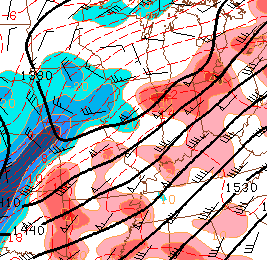
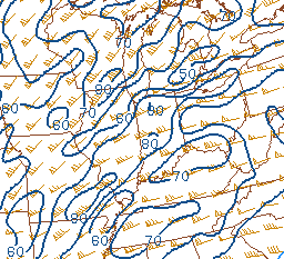
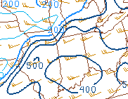
An upper level disturbance embedded in strong west-southwest flow (Fig 2) lifted out of the Plains and induced a deepening surface frontal wave (Fig 3) northeast into the Great Lakes region late February 28th into early March 1st. Strong upper divergence in the left exit region of a 140 kt plus 300mb jet (Fig 7) combined with impressive low level moisture transport (Fig 1,8) aided in convective development near the system warm front across far northern Indiana and southwest Lower Michigan in the evening. A second line of thunderstorms accompanied the trailing cold front early March 1st.
 |
 |
 |
|
Figure 1: 850mb Temperature Advection (850mb temp advection (fill), 850mb height, 850 mb wind) |
Figure 2: 80-100 kt 500mb Jet (500mb height, temp, wind) |
Figure 3: 06z 3/1/17 Sfc Analysis
|
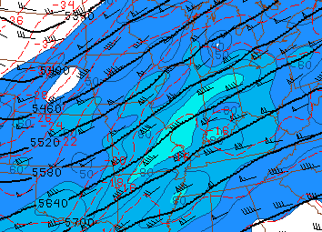
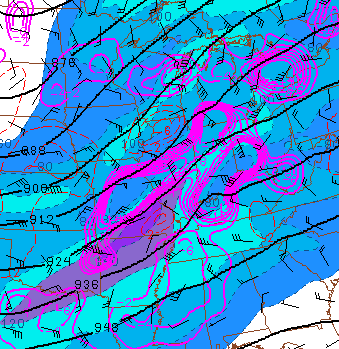
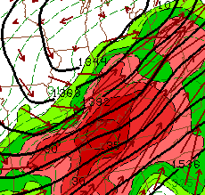
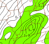
The near storm environment was characterized by modest instability (500-1000 j/kg of MUCAPE, Fig 4), strong deep layer shear (60 knots plus 0-6km Bulk Shear, Fig 5) and 0-3km helicity values (Fig 6) favorable for tornadoes.
 |
 |
 |
|
Figure 4: 02z 3/1/17 MUCAPE (j/kg) (500-1000 j/kg of MUCAPE locally) |
Figure 5: Deep Layer Shear (0-6km) (60-80 knots of Deep Shear locally) |
Figure 6: 0-3km Storm Relative Helicity (300-400 m2/s2 locally) |
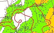
Additional environmental data.
 |
 |
 |
|
Figure 7: 300mb Winds & Upr Divergence (300 mb Isotachs (fill), 300mb heights, 700-500 mb layer Omega (magenta))
|
Figure 8: 850 mb Moisture Tranport |
Figure 9: Precipitable Water (in) |
 |
Media use of NWS Web News Stories is encouraged! Please acknowledge the NWS as the source of any news information accessed from this site. |
|