Overview
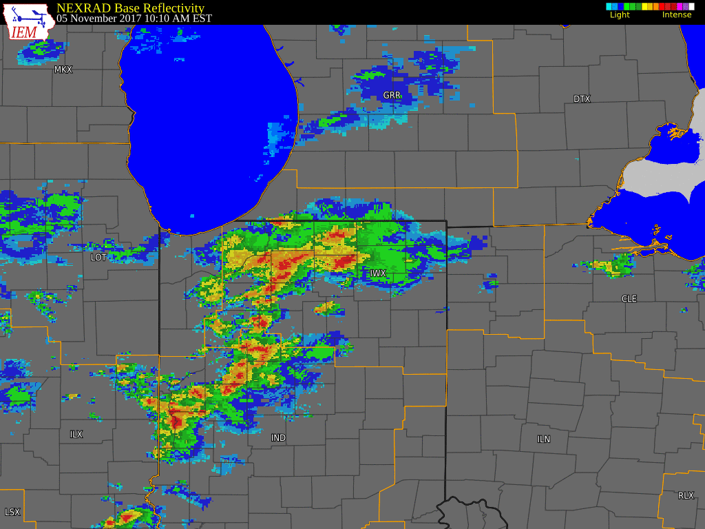
A warm front provided the focus for morning thunderstorms that eventually turned into a bowing line segment across NE Indiana into NW Ohio. Storms also developed across central Indiana and moved into portions of NE Indiana and NW Ohio. A cyclic supercell impacted Blackford and Jay counties with a long tracked EF-3 tornado and associated damage. There was also straight line wind damage observed in Wauseon, OH. Flooding issues occurred in some areas due to training and efficient rain producers. NWS Storm survey teams investigated the damage Monday November 6, 2017. Final survey results will be updated on this page once they are complete. Preliminary updated PNS can be found here.
You can view the storm summary pages from the surrounding offices by clicking on the relevant office: Indianapolis Wilmington OH
Tornadoes:
|
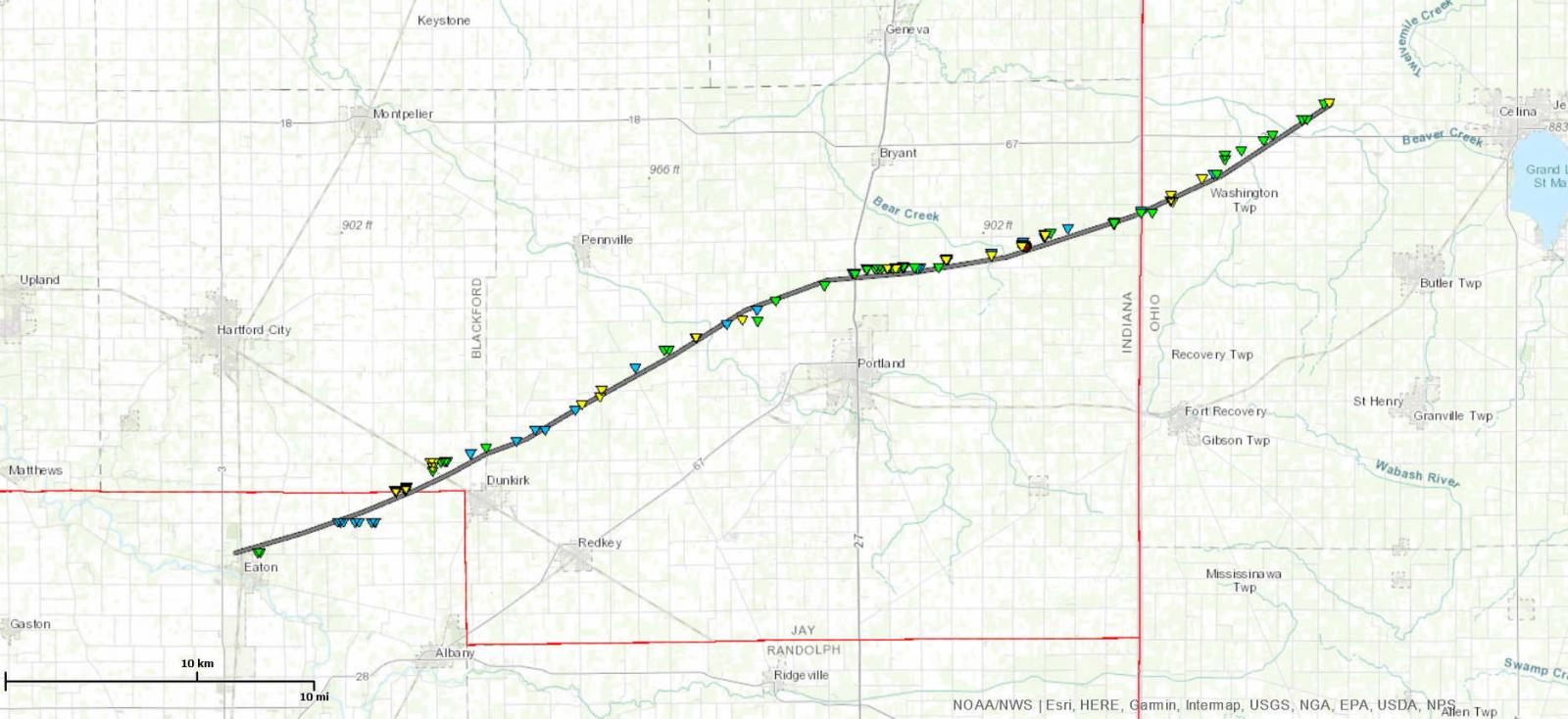
Tornado - Long Track Tornado Mercer, OH
|
||||||||||||||||
The Enhanced Fujita (EF) Scale classifies tornadoes into the following categories:
| EF0 Weak 65-85 mph |
EF1 Moderate 86-110 mph |
EF2 Significant 111-135 mph |
EF3 Severe 136-165 mph |
EF4 Extreme 166-200 mph |
EF5 Catastrophic 200+ mph |
 |
|||||
Wind & Hail:
Wind
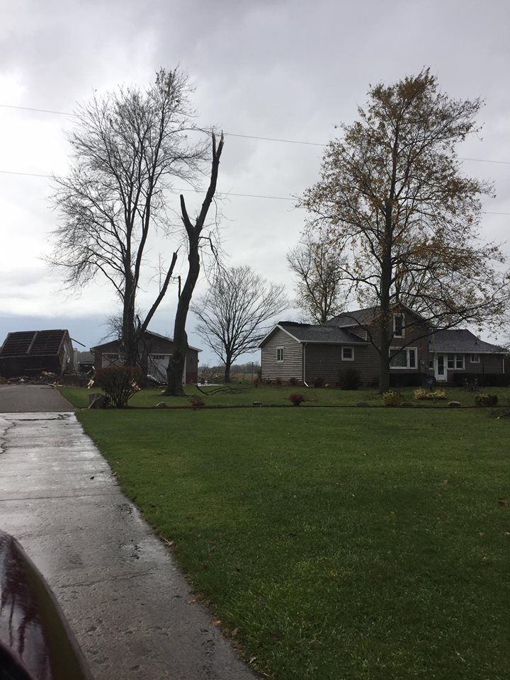
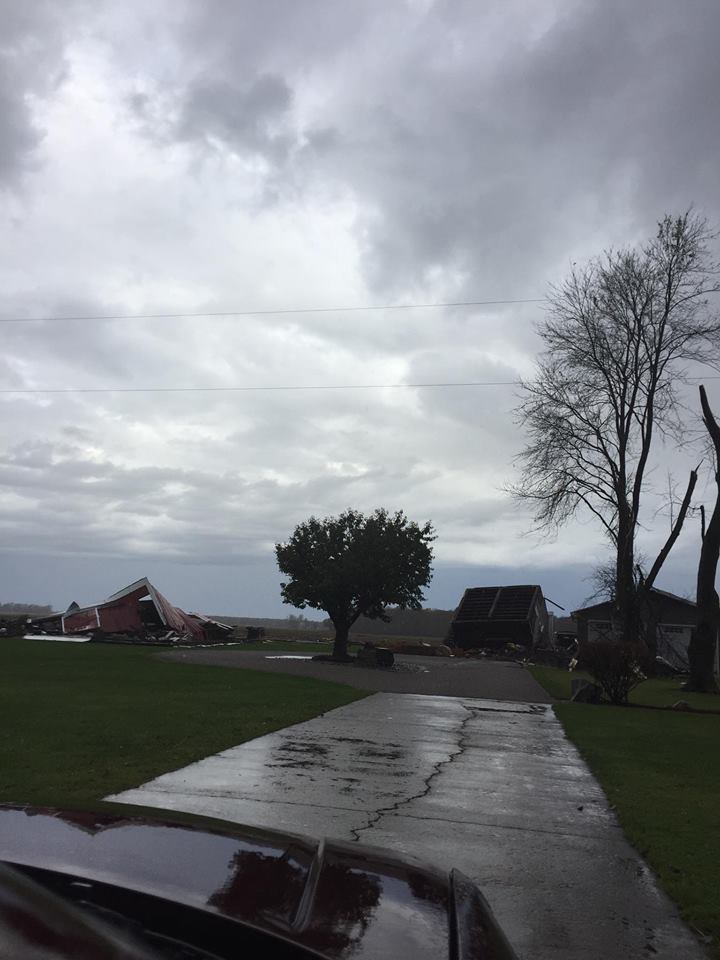
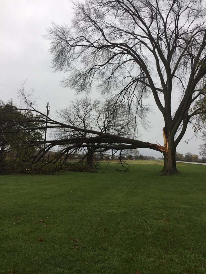
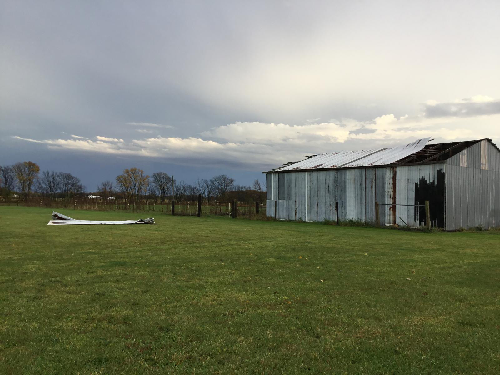
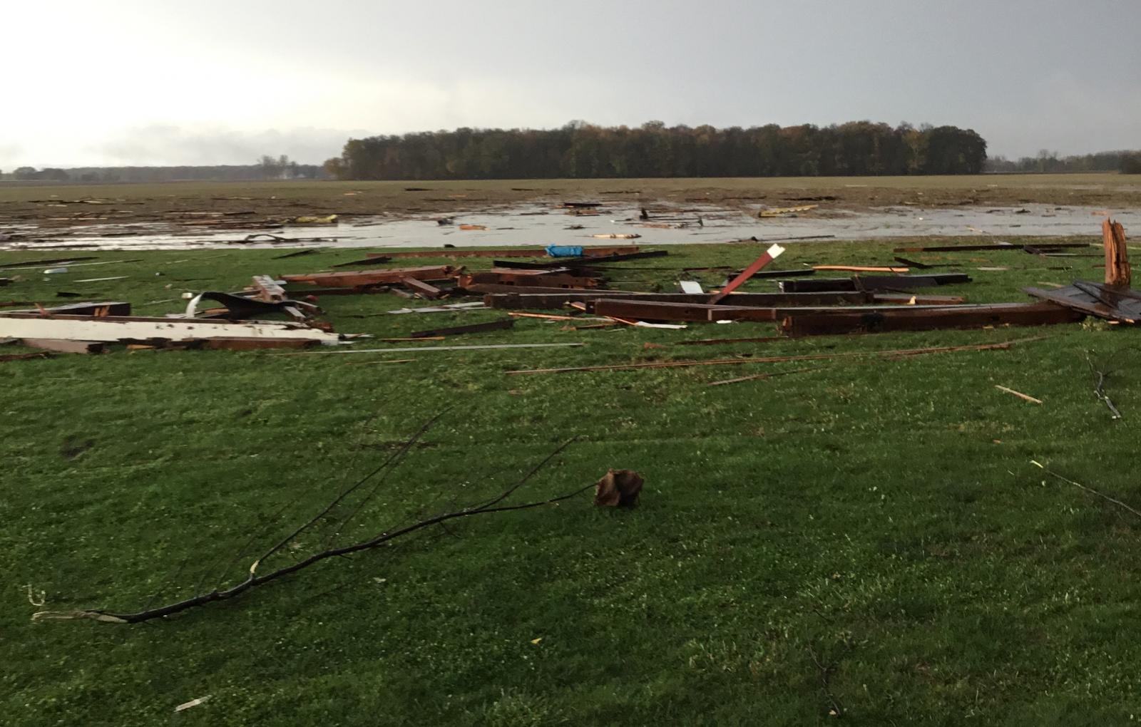
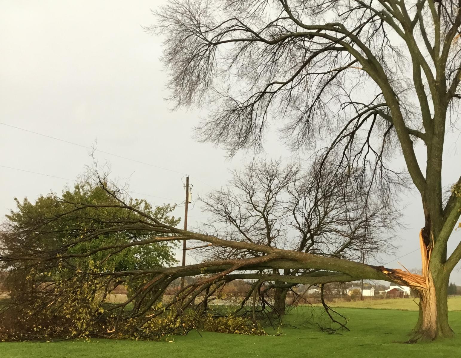
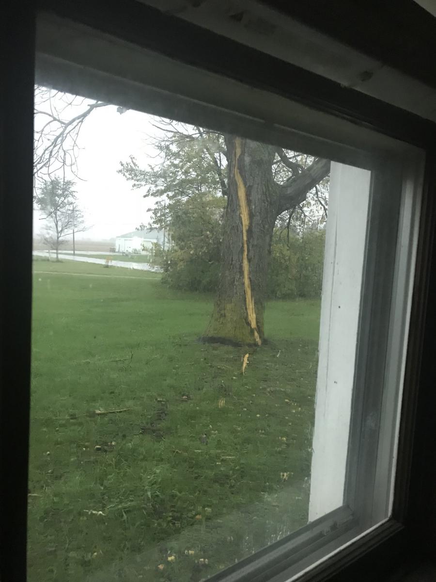
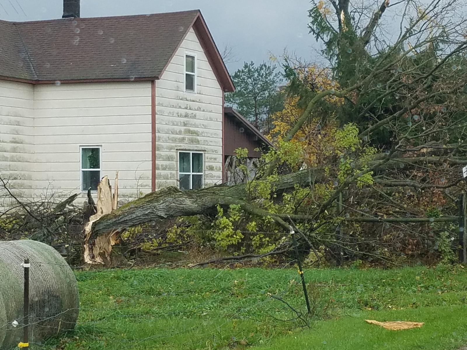
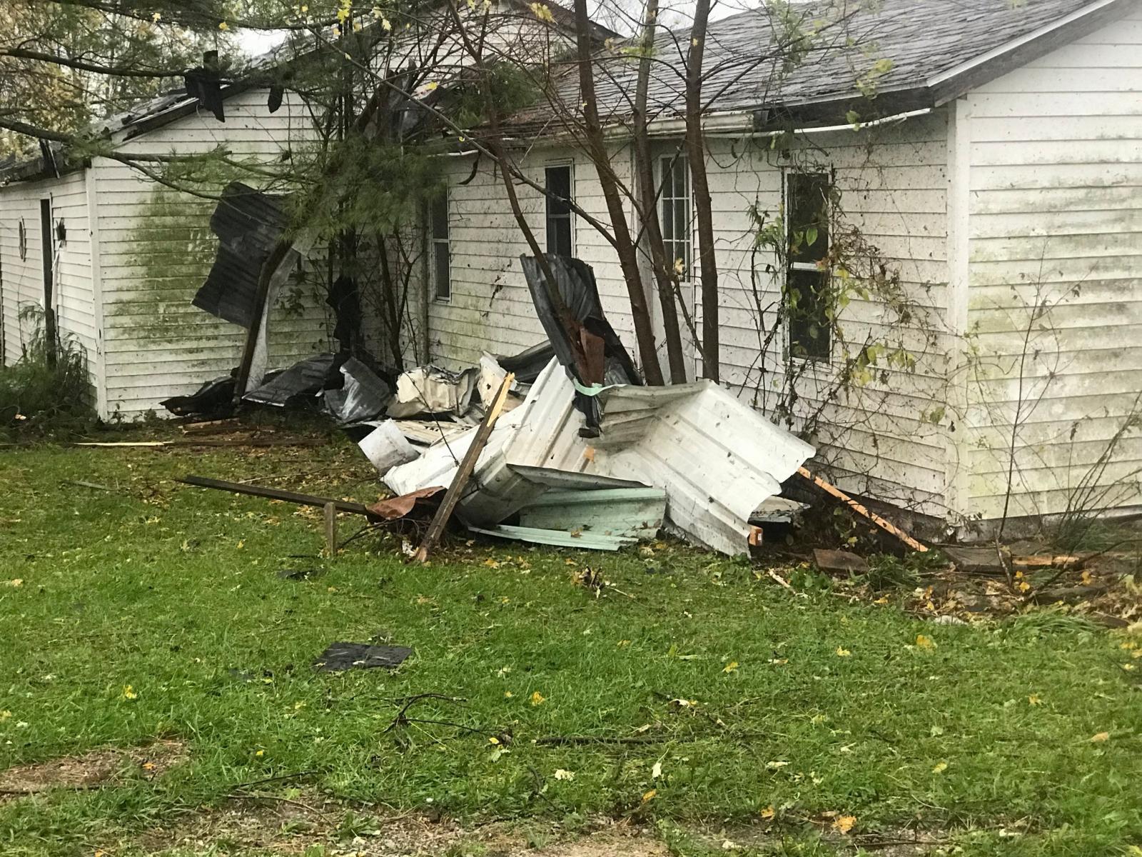
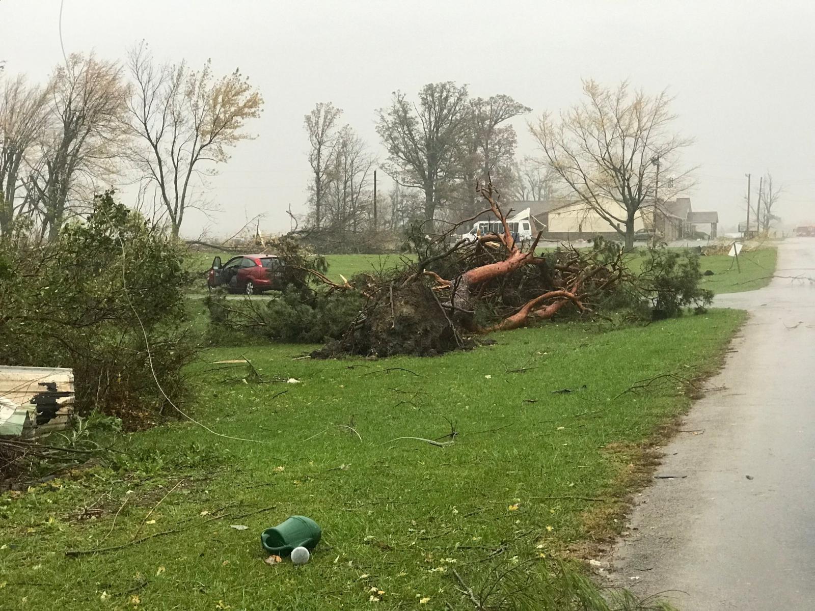
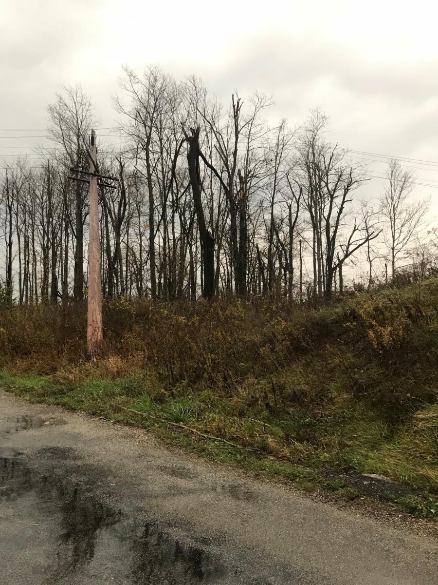
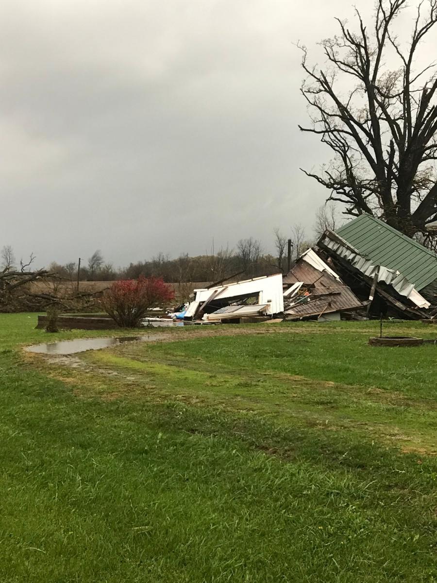
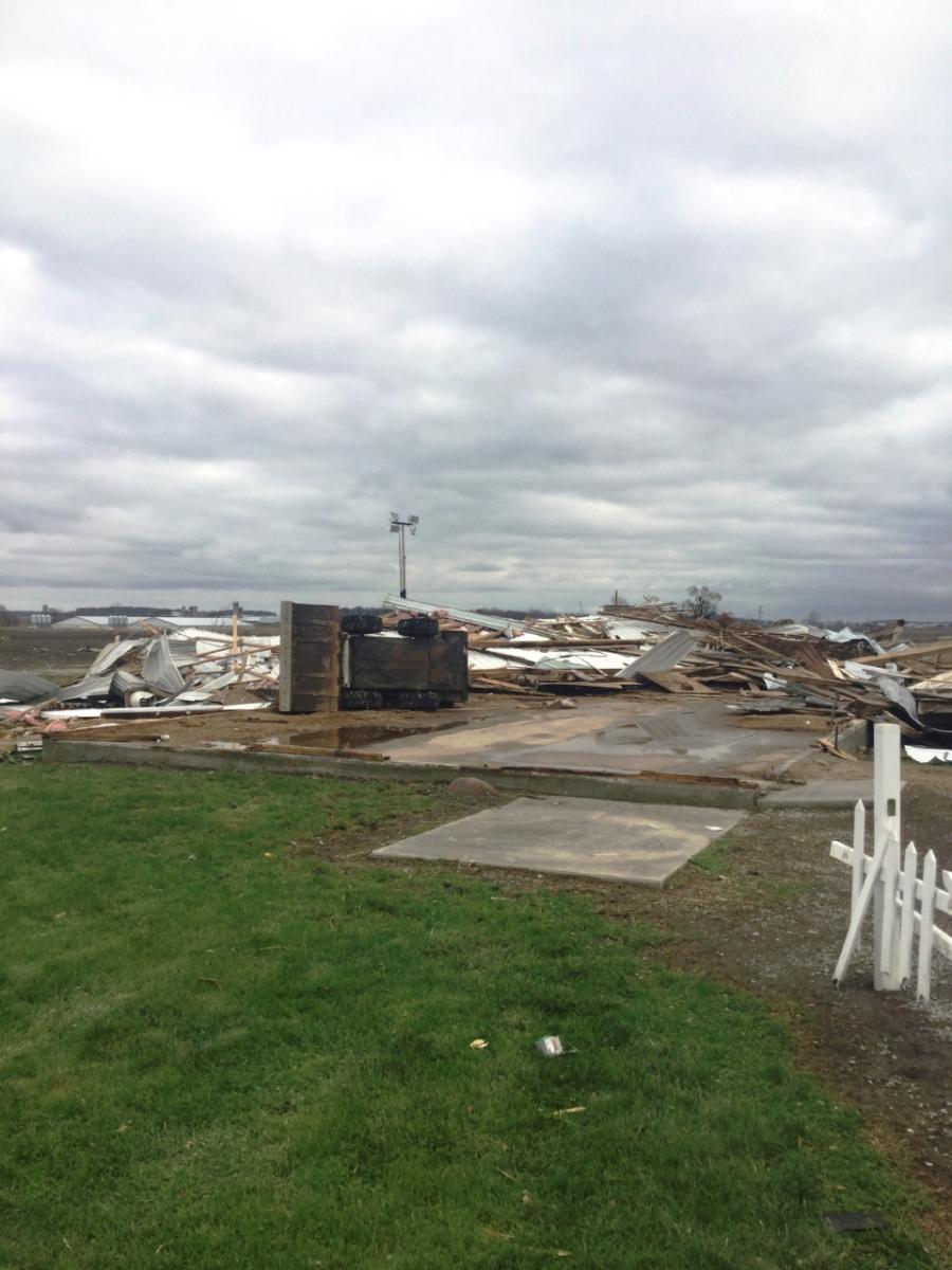
Severe thunderstorms led to damaging winds across portions of the area. Northwest Ohio had the majority of straight line wind damage reports, particularly in Wauseon and Archbold, OH. Other areas include Noble and Grant Counties, Indiana. See the "Storm reports" Tab for more details on the specific reports. If you had damage in an area not mentioned, please send your report to our webmaster at w-iwx.webmaster@noaa.gov so we can include it in our event summary and records. Thanks to those who submitted reports and pictures throughout the event!
 |
 |
 |
 |
|
Wind Damage in Wauseon, OH. Courtesy of Andrew Moore |
Wind Damage in Wauseon, OH. Courtesy of Adam Benner. |
Wind Damage in Wauseon, OH. Courtesy of Adam Benner. | Wind Damage in Wauseon, OH. Courtesy of Adam Benner. |
 |
 |
 |
 |
|
Wind Damage in Williams County, Ohio Courtesy of Dawn Baldwin (EMA) |
Wind Damage in Williams County, Ohio Courtesy of Dawn Baldwin (EMA) | Wind Damage in Williams County, Ohio. Courtesy of Dawn Baldwin (EMA) | Lightning Damage in Wauseon, OH. Courtesy of Eric Harteis. |
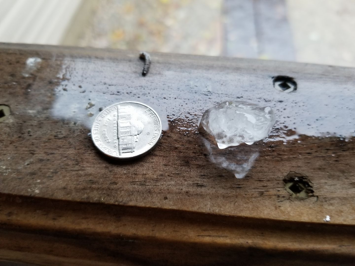
Hail
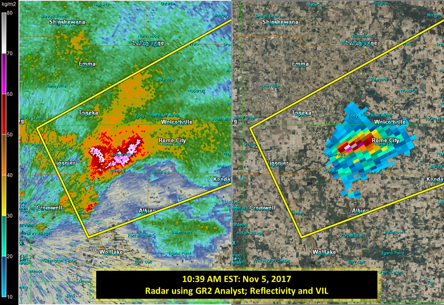
Small hail was recorded with the afternoon thunderstorms ranging from pea to nickel sized. One example of the hail observed is from just east of Topeka, IN, around 10:39 AM EST. The center image shows the high reflectivity (reds, pinks, and whites indicating heavy rain or hail) at the surface, as observed by radar. It also shows the VIL, which stands for vertically integrated water. The VIL of a storm is useful in determining the potential severity of a storm, especially in terms of maximum hail size. The image on the right is a cross section of the radar data (a vertical slice of the storm). This shows the higher reflectivity (pinks, reds, and whites are hail) aloft, which is falling to the surface. Read more about how hail forms here.
 |
 |
 |
|
Hail from just east of Topeka, Indiana. Photo courtesy of Tim Feipel. Reported to NWS around 10:40 AM EST via social media. |
Radar shot using GR2 Analyst from 10:39 AM EST. This shows the hail at the surface at the time of Tim' report, indicated by the reds, pinks, and whites. The image on the right shows the VIL. | Cross section of the same time as the other images, using GR2 Analyst to view the radar data. This shows the hail aloft, falling with the heavy rain to the surface. |
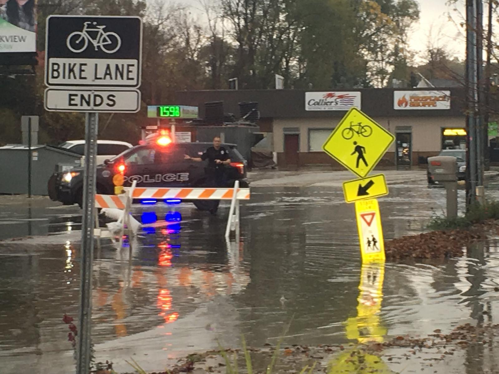
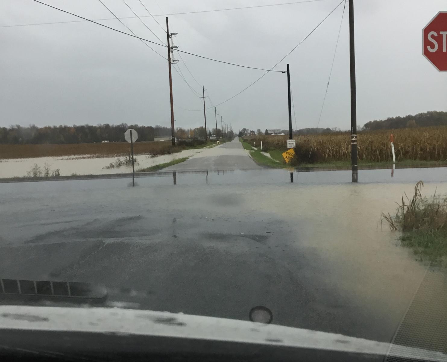
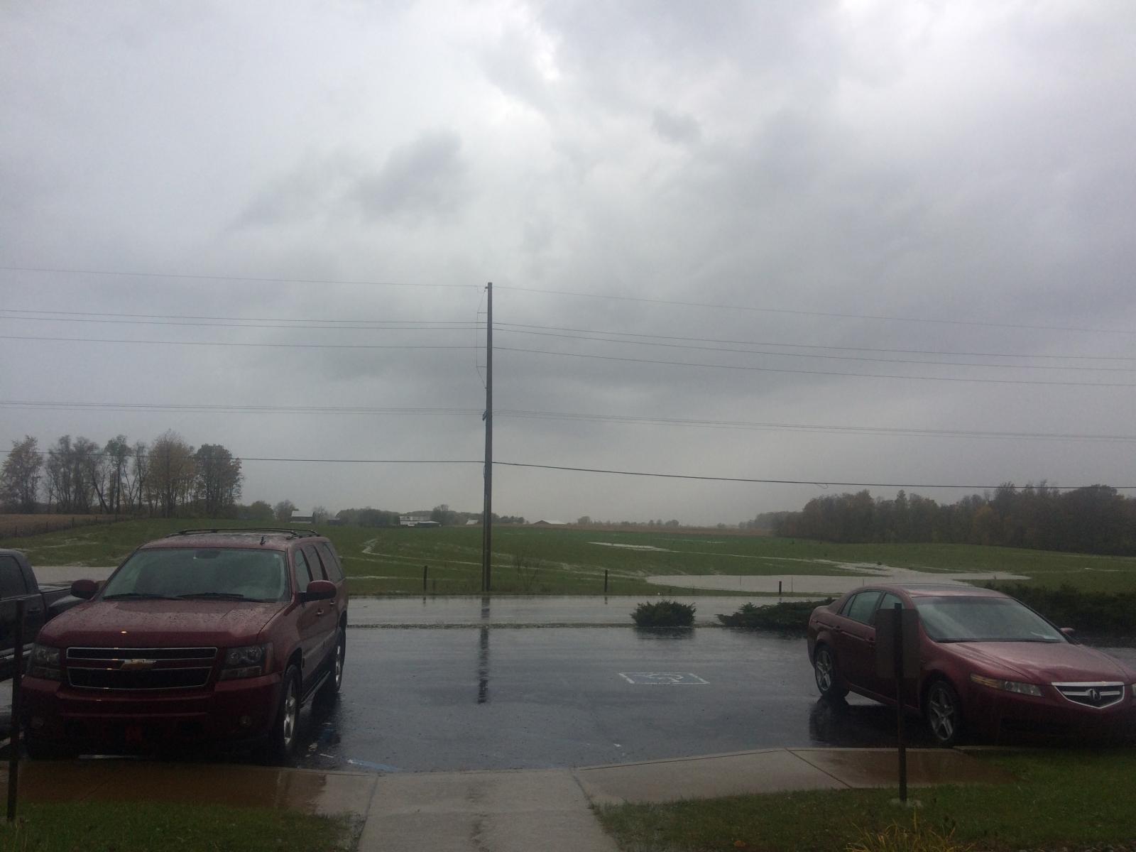
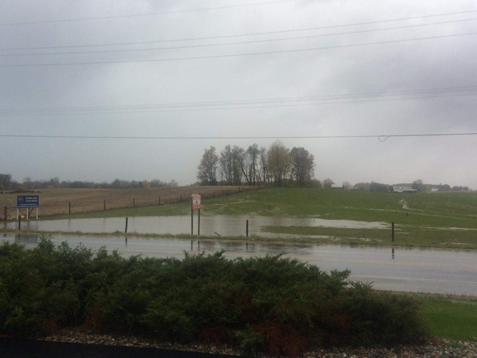
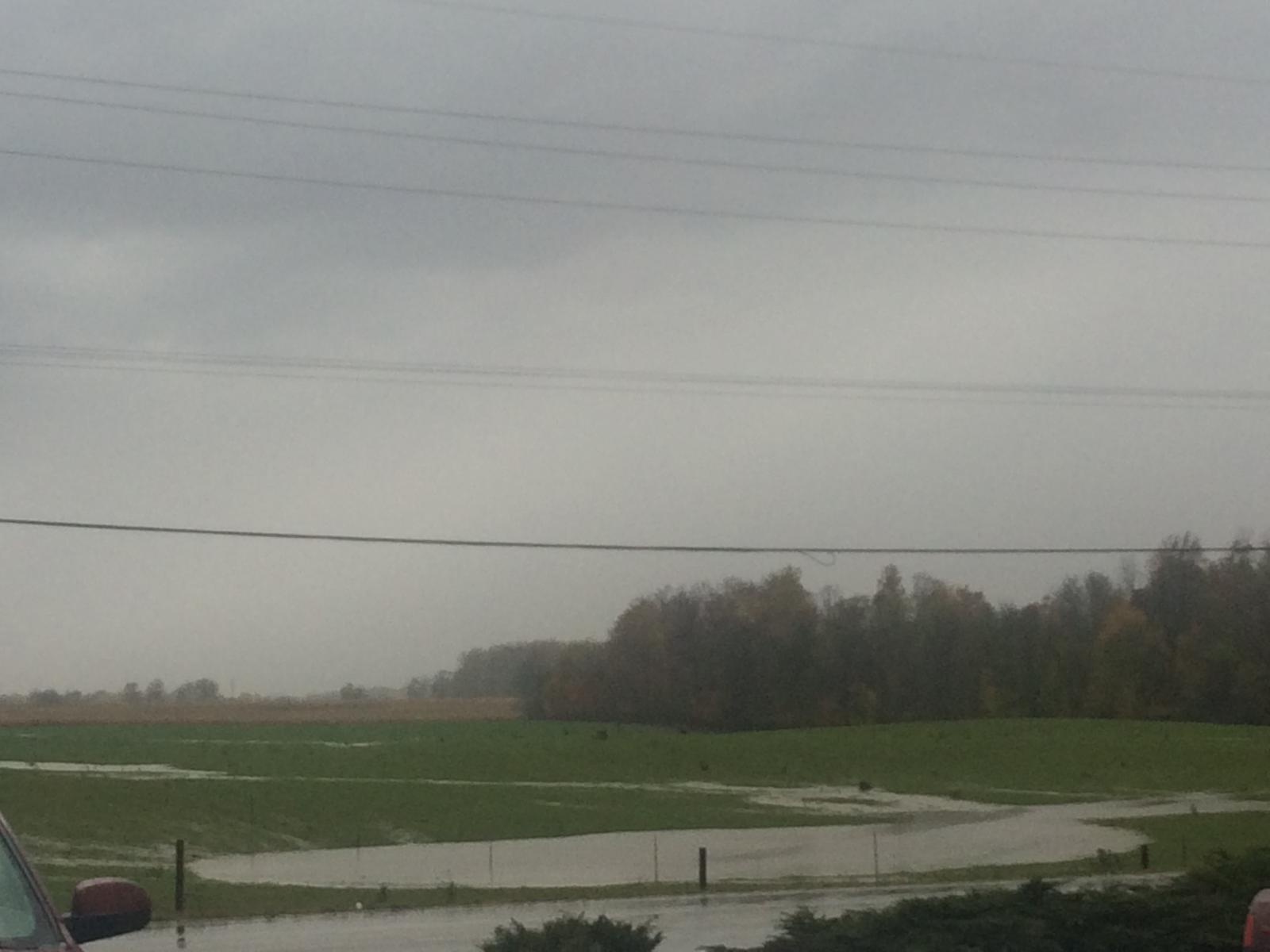
Flooding
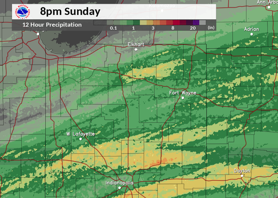
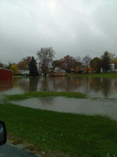
Widespread areas of 1 inch plus rainfall fell across southern and eastern portions of the County Warning area. Localized areas saw over 3 inches as strong thunderstorms trained over the same area for several hours including 3.1 inches of rainfall measured here at the NWS Northern Indiana office. Several roads in Kosciusko and Noble County in Indiana, along with portions of Williams County, OH were flooded as seen below in the images.
Radar/Photos
 |
 |
 |
 |
|
Radar Estimated Storm Total rainfall by 8 pm EST Sunday November 5, 2017 |
Flooding in Albion, IN. Courtesy of Jason Brown. |
Flooding in Winona Lake, IN. Courtesy of Matt Rudkin (WSBT) | Flooding in Williams County, OH. Courtesy of Dawn Baldwin (EMA). |
 |
 |
 |
| Agricultural Flooding at NWS Northern Indiana November 5, 2017. Courtesy of Megan Dodson. | Agricultural Flooding at NWS Northern Indiana November 5, 2017. Courtesy of Megan Dodson. | Agricultural Flooding at NWS Northern Indiana November 5, 2017. Courtesy of Megan Dodson. |
Below are a couple of videos sent to us by Jason Agler, along US 33 near Ligonier and Albion, IN.
Photos & Video:
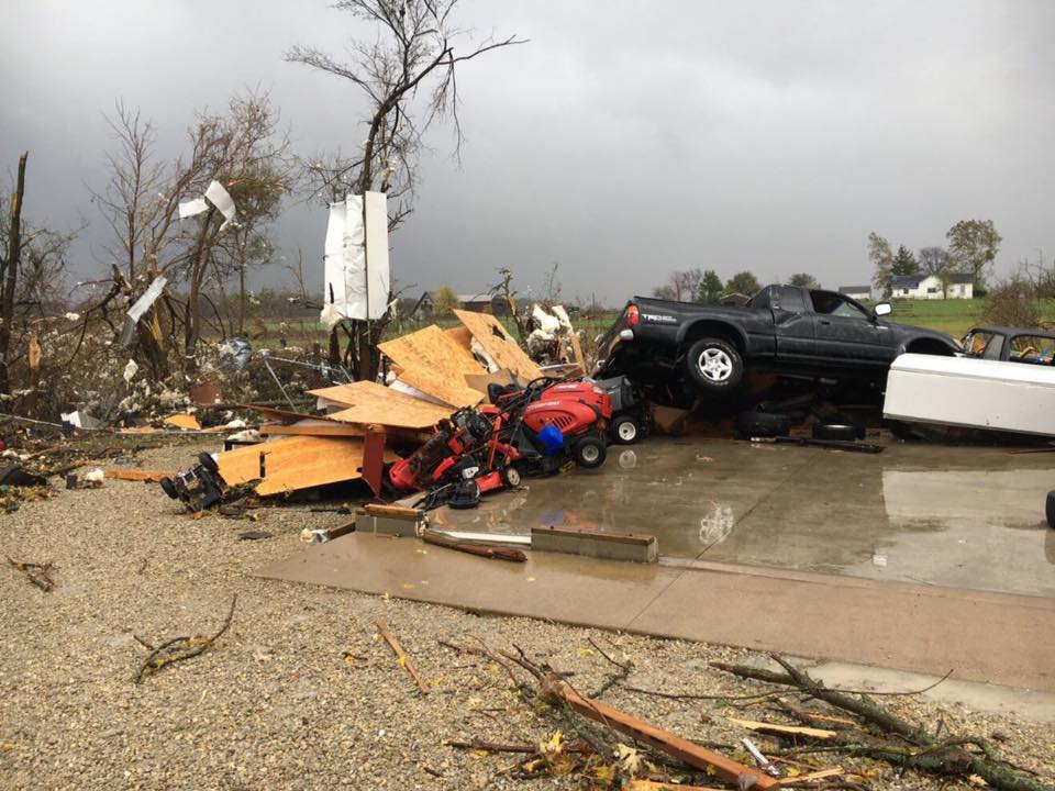
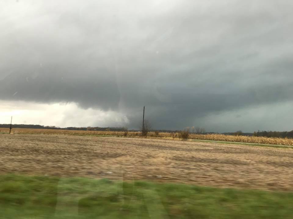
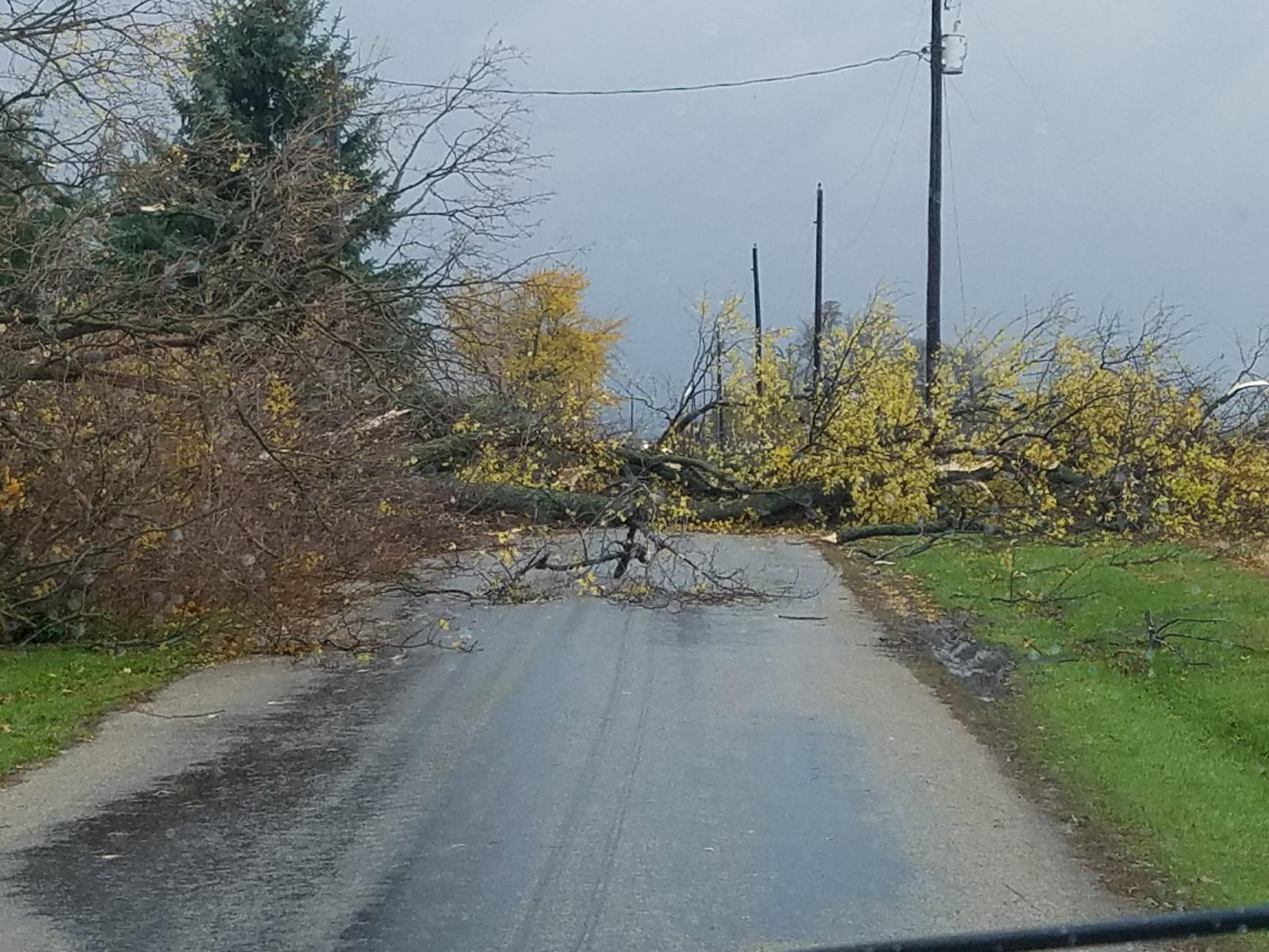
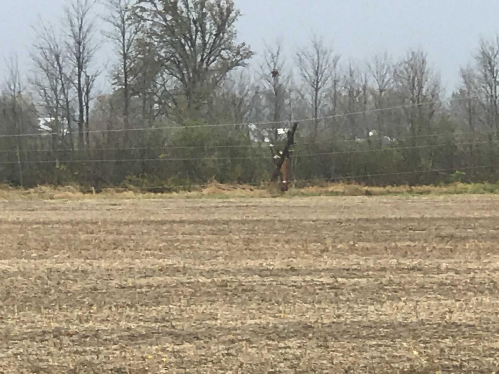
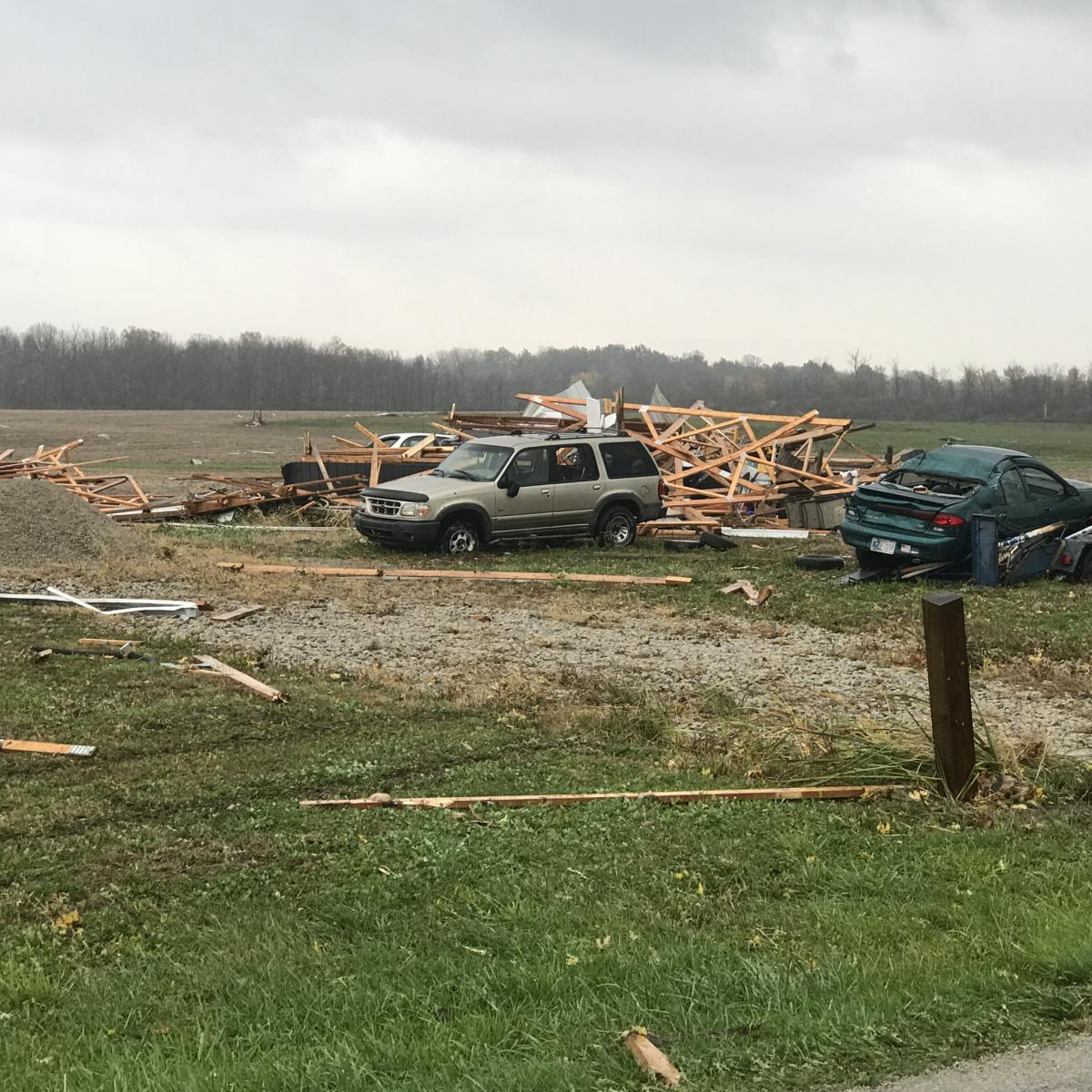
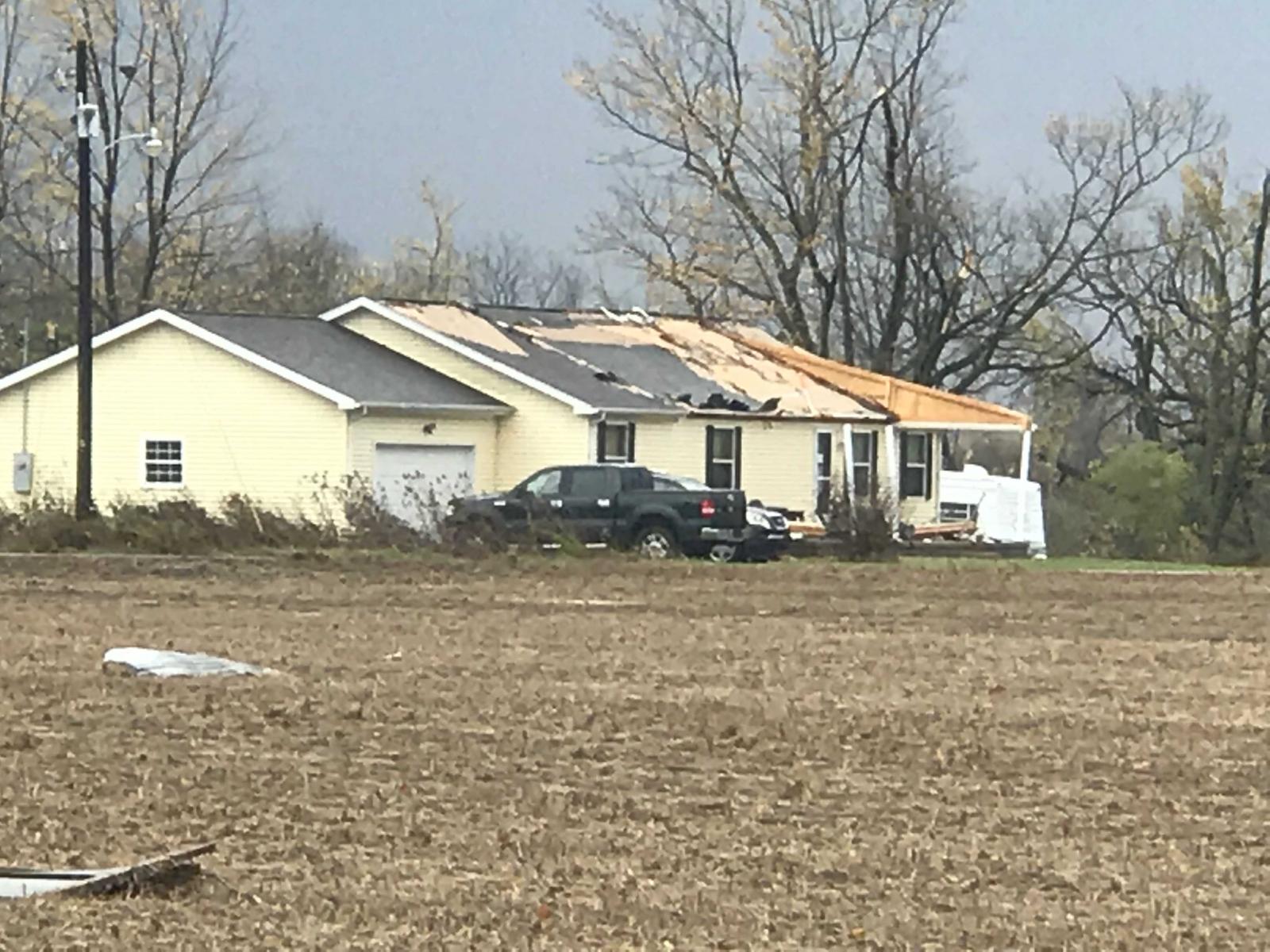
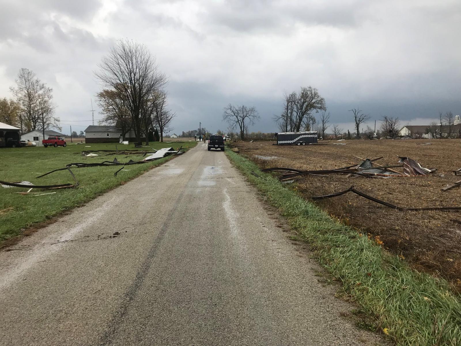
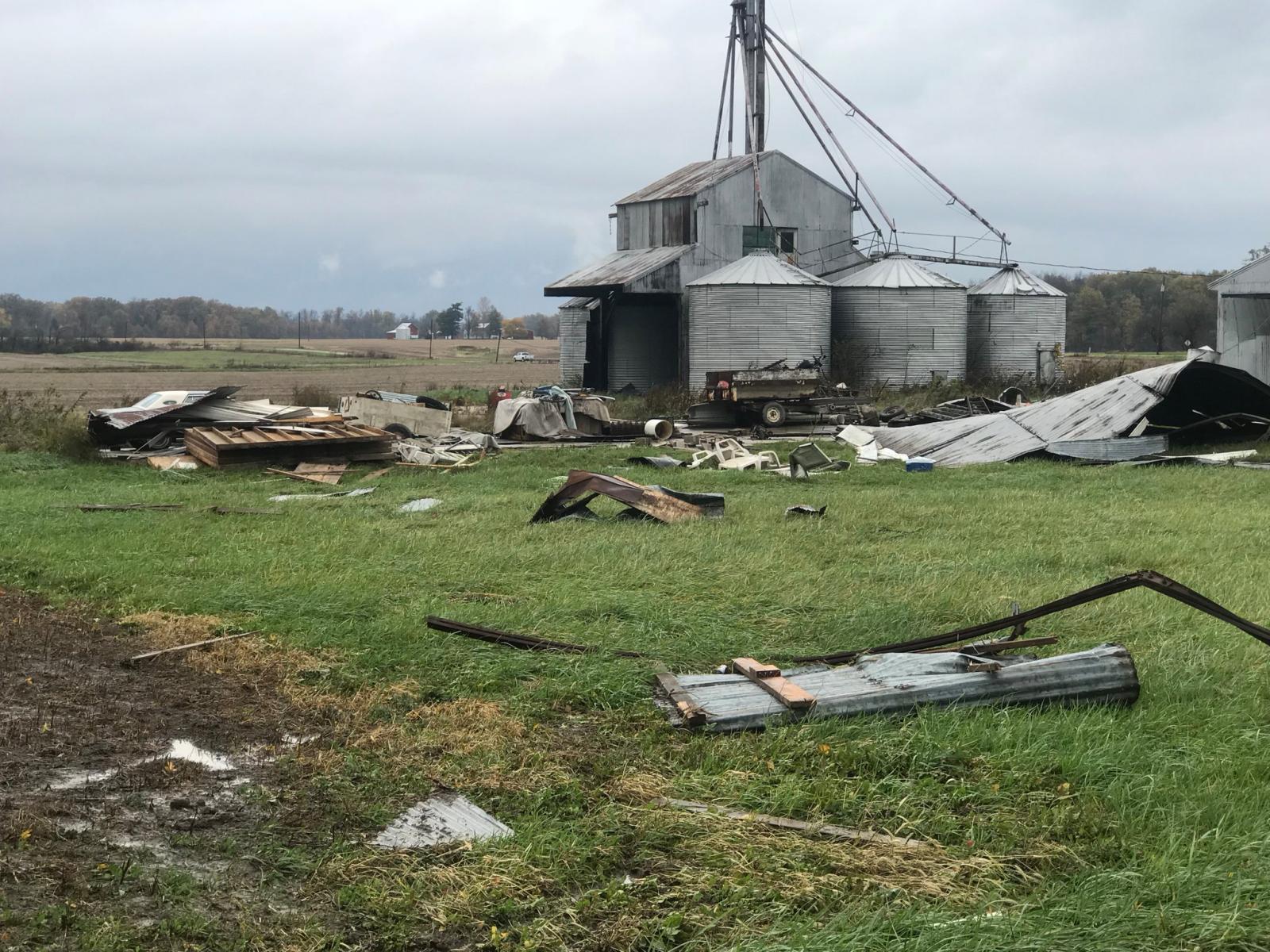
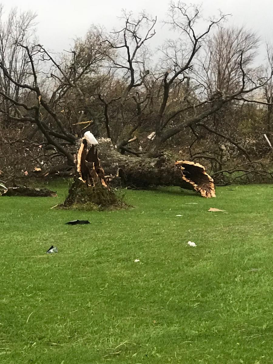
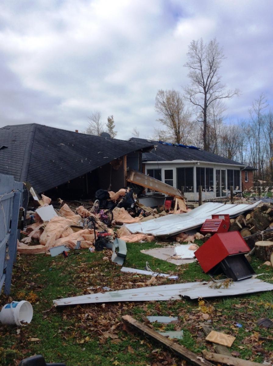
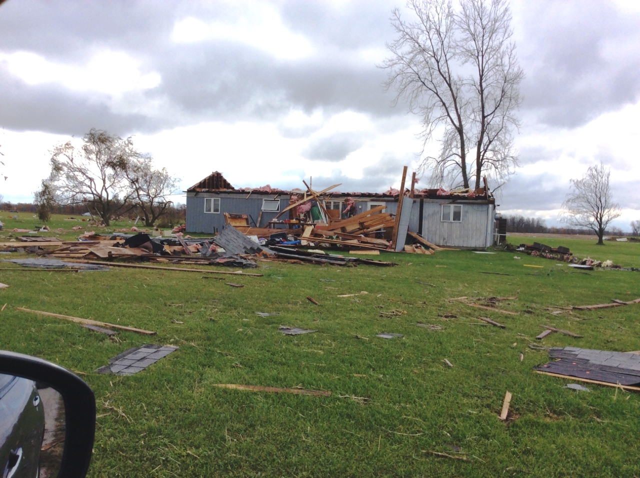
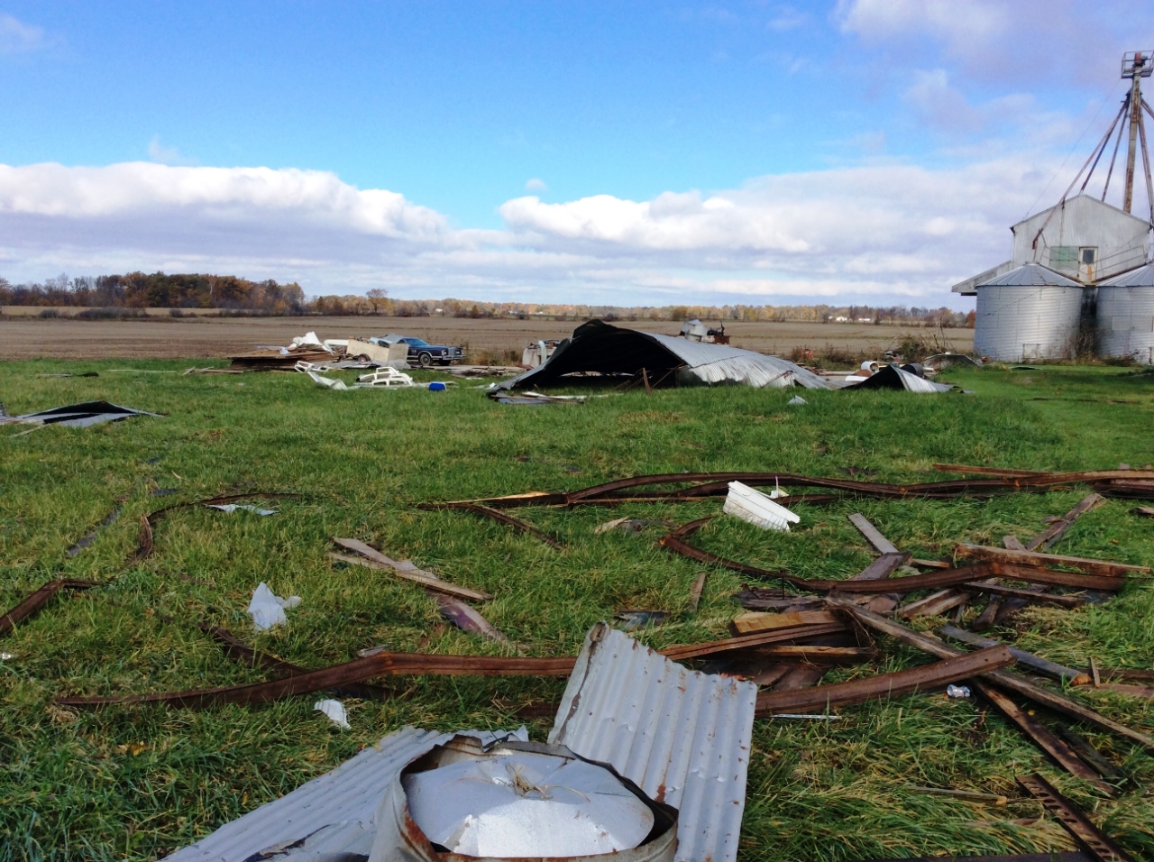
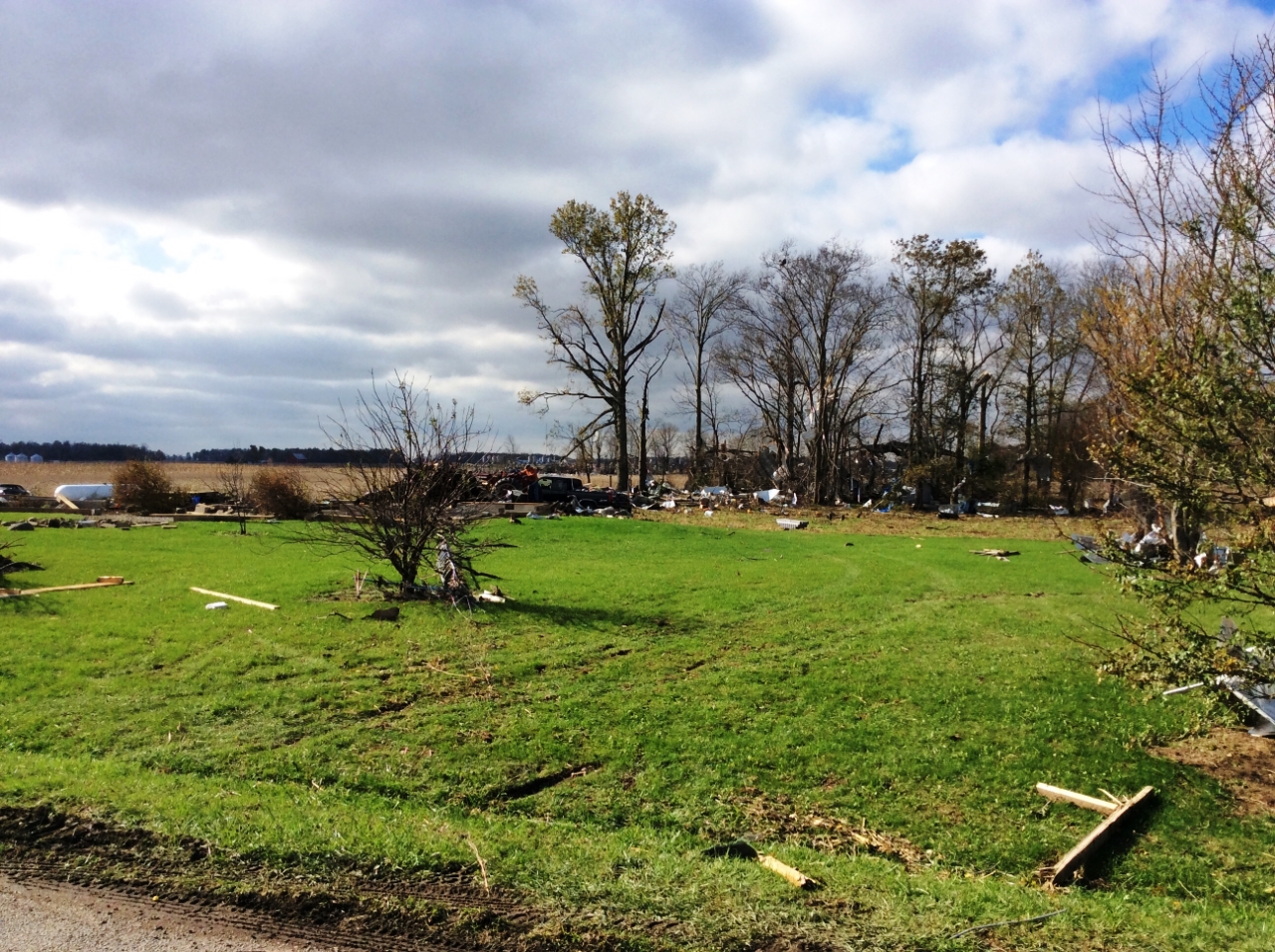
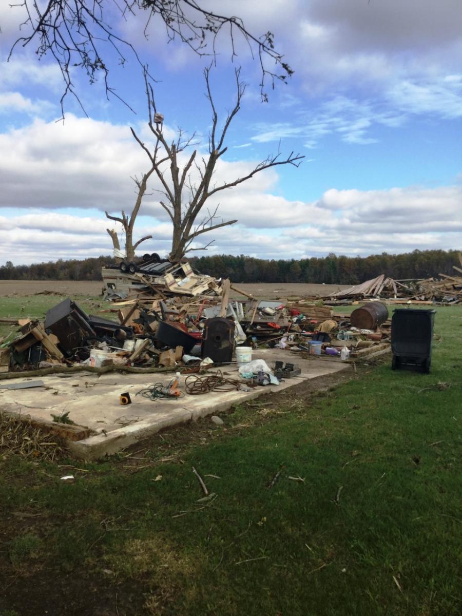
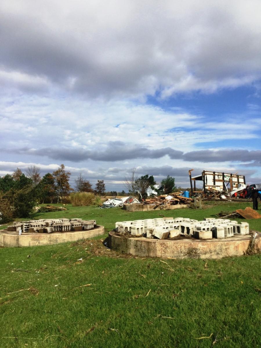
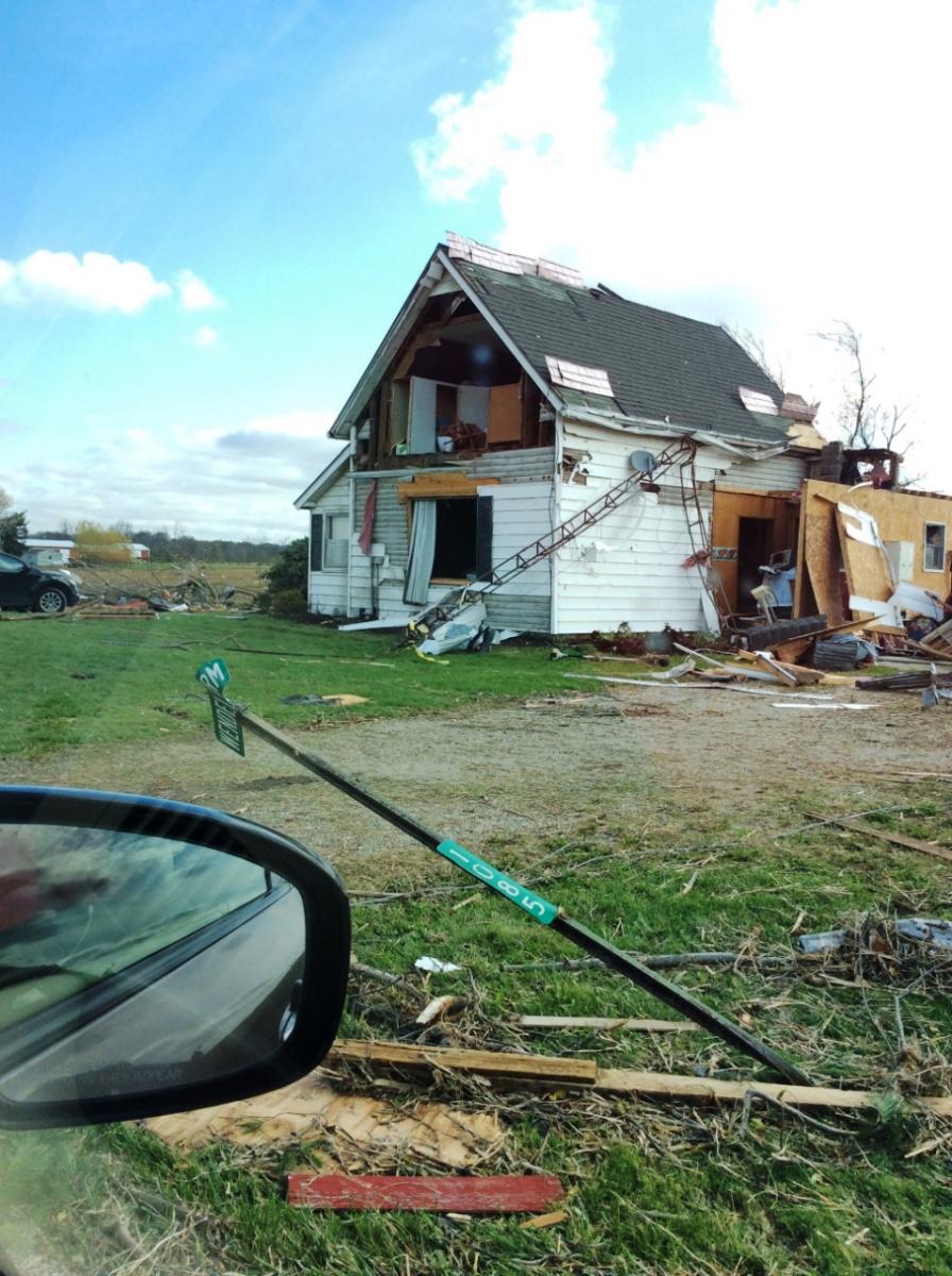
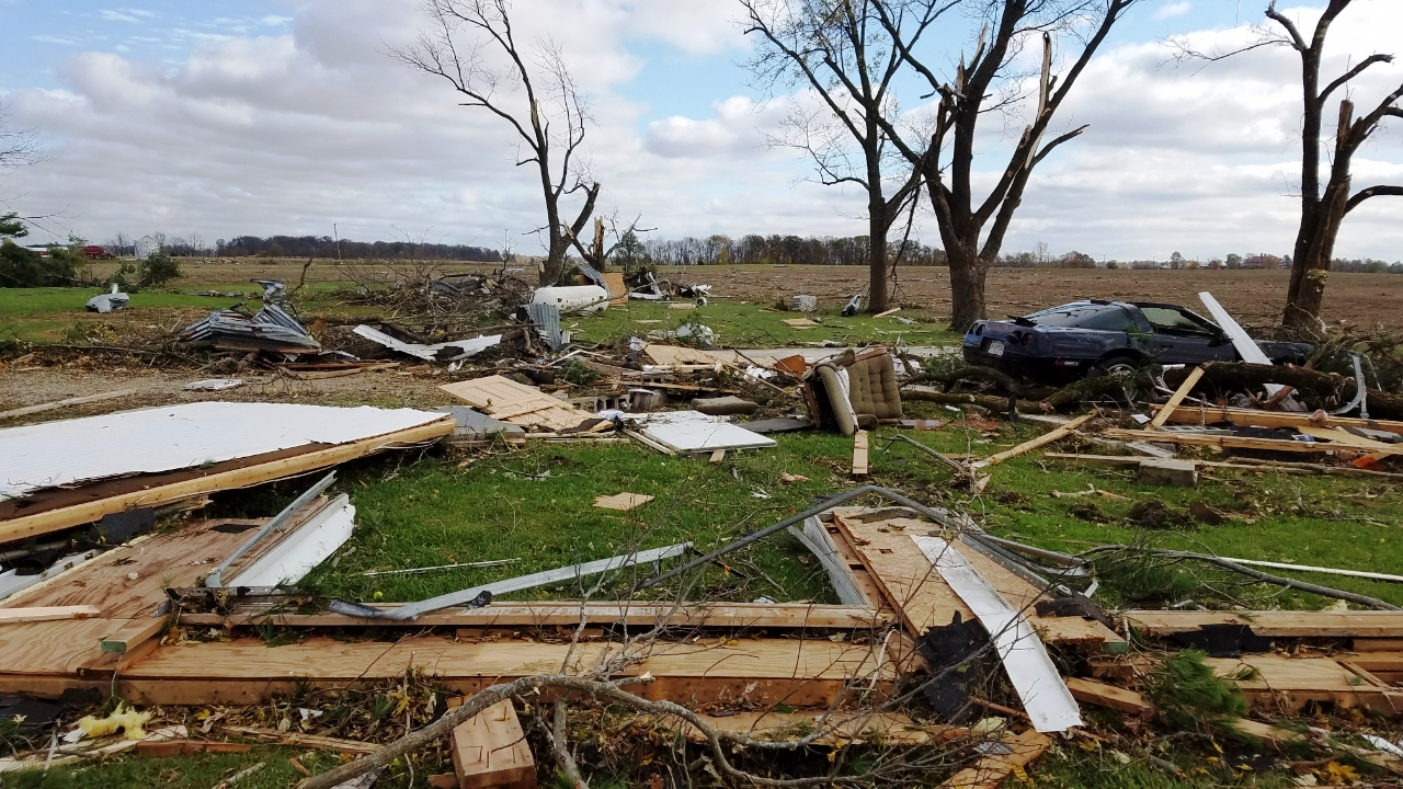
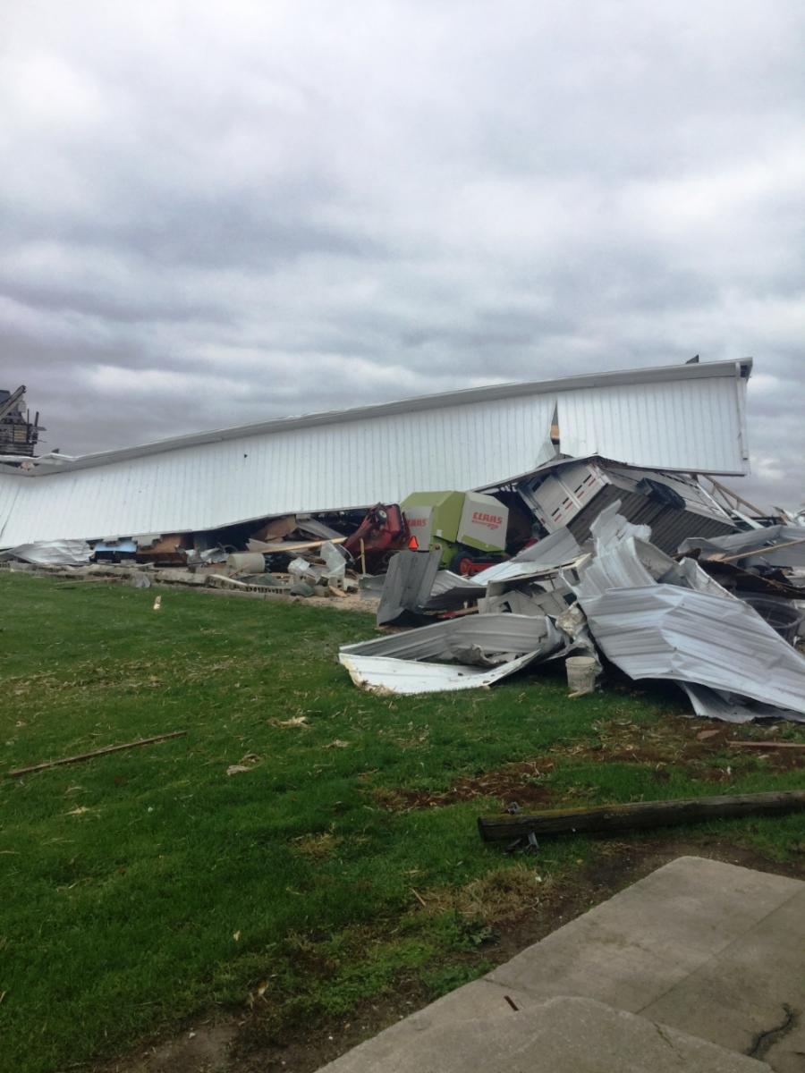
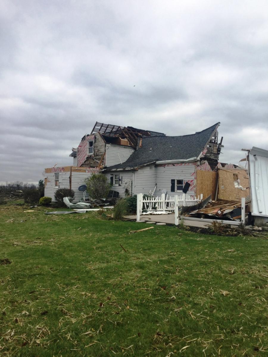
Blackford & Jay County, Indiana Tornado
Below are videos and images of the EF-2 tornado that went through Blackford and Jay Counties in the northern Indiana forecast area. Thanks to everyone who submitted their reports, videos, and photos. We really appreciate it!
Video taken near Portland, IN - courtesy of Jarod Hewett / LSM
Photos
 |
 |
 |
 |
| Pennville, IN. Courtesy of Matt Leach. | Pennville, IN. Courtesy of Matt Leach. | Dunkirk, IN. Courtesy of Brad Gollifer. | Dunkirk, IN. Courtesy of Brad Gollifer. |
 |
 |
 |
 |
| Dunkirk Area. Courtesy of Roger Overby. | Dunkirk Area. Courtesy of Roger Overby. | Dunkirk Area. Courtesy of Roger Overby. | Dunkirk Area. Courtesy of Roger Overby. |
 |
 |
 |
 |
| Dunkirk Area. Courtesy of Roger Overby. | Dunkirk Area. Courtesy of Roger Overby. | Dunkirk Area. Courtesy of Roger Overby. | Dunkirk Area. Courtesy of Roger Overby. |
 |
 |
 |
 |
| Dunkirk Area. Courtesy of Roger Overby. | Dunkirk Area. Courtesy of Roger Overby. | Dunkirk Area. Courtesy of Roger Overby. | Dunkirk Area. Courtesy of Roger Overby. |
 |
 |
 |
 |
| West of Dunkirk, IN. (NWS Storm Survey) | Northwest of Dunkirk, IN.(NWS Storm Survey) | Northwest of Dunkirk, IN.(NWS Storm Survey) | West of Portland, IN.(NWS Storm Survey) |
 |
 |
 |
 |
| North of Portland, IN. (NWS Storm Survey) | North of Portland, IN. (NWS Storm Survey) | North of Portland, IN. (NWS Storm Survey) | North of Portland, IN. (NWS Storm Survey) |
 |
 |
 |
 |
| Northeast of Portland, IN. (NWS Storm Survey) | Northeast of Portland, IN. (NWS Storm Survey) |
Northeast of Portland, IN. (NWS Storm Survey) |
Northeast of Portland, IN. (NWS Storm Survey) |
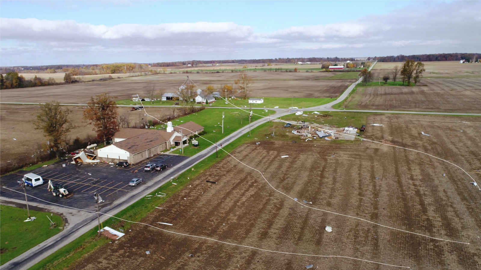
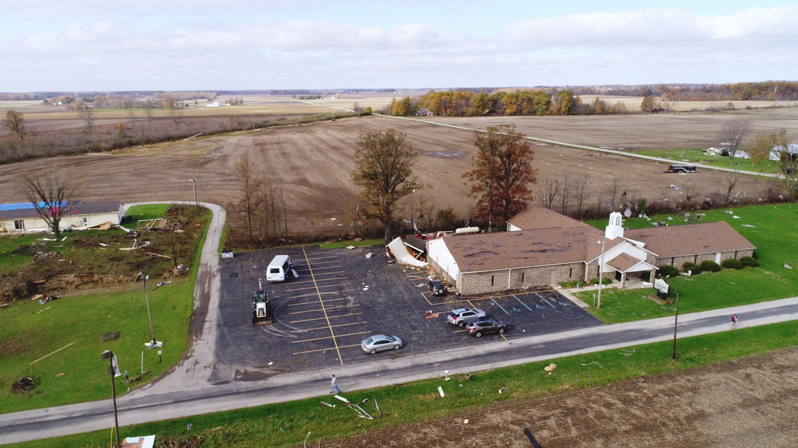
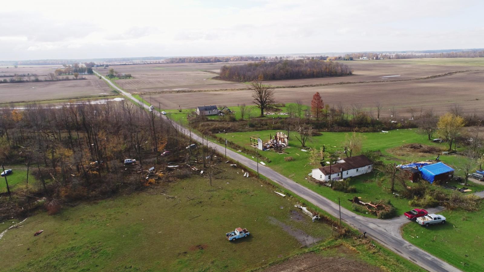
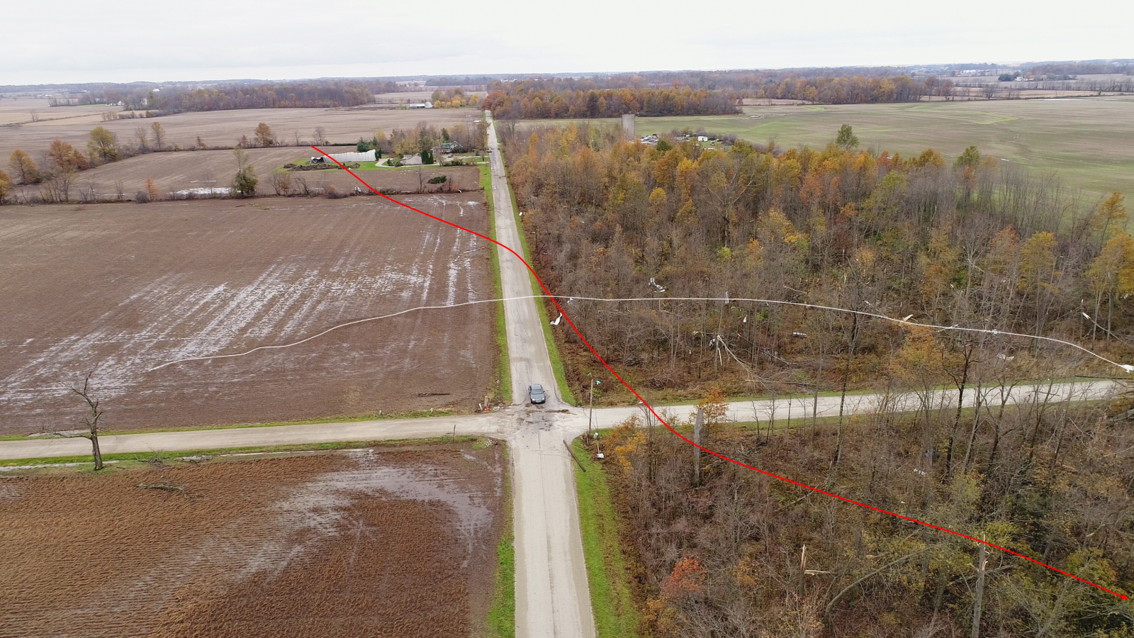
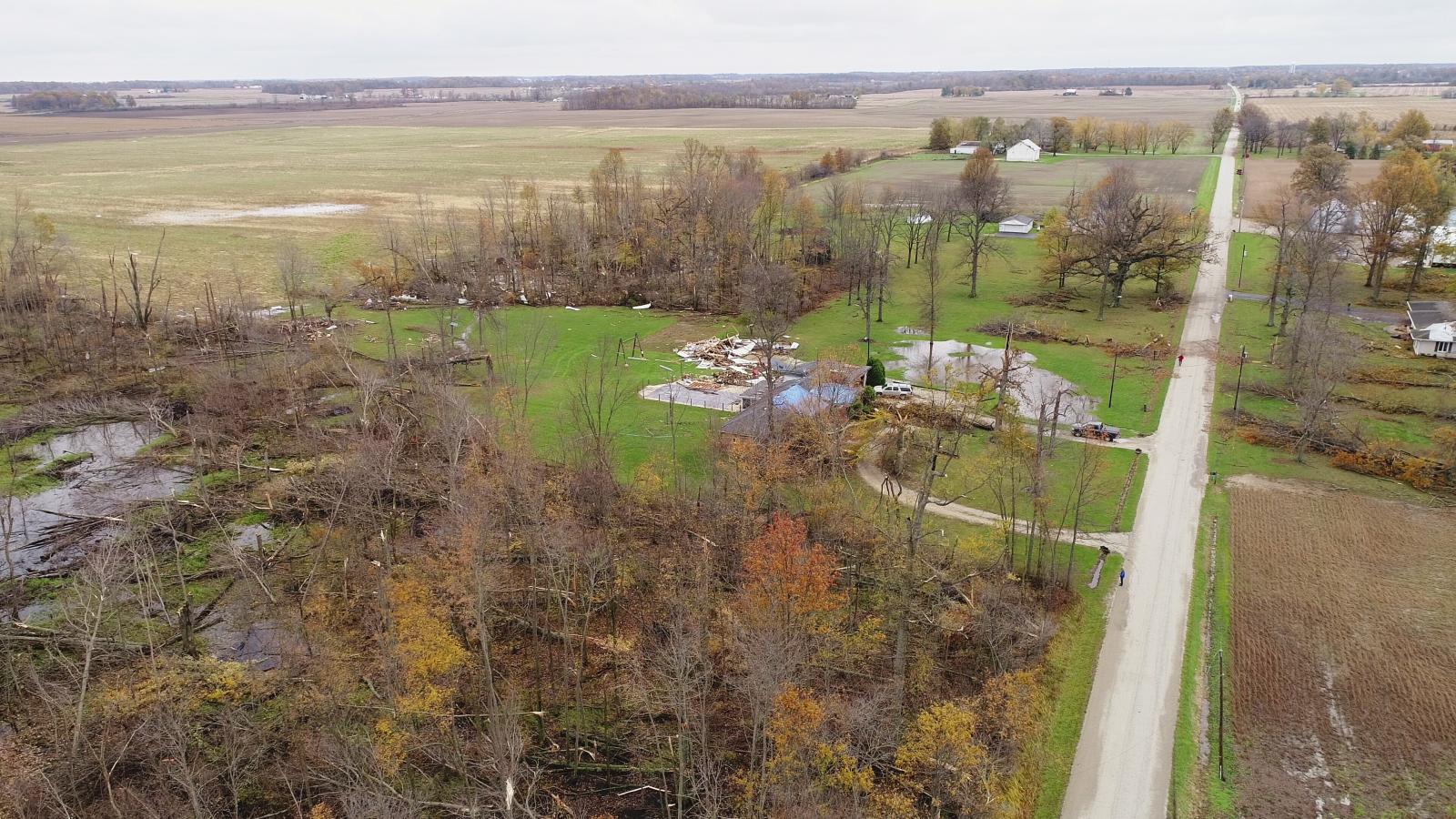
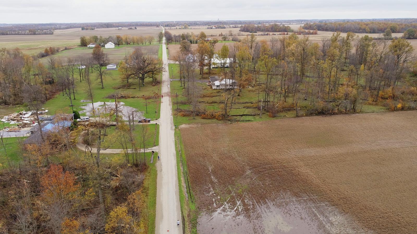
Drone images courtesy of James Buckner
 |
 |
 |
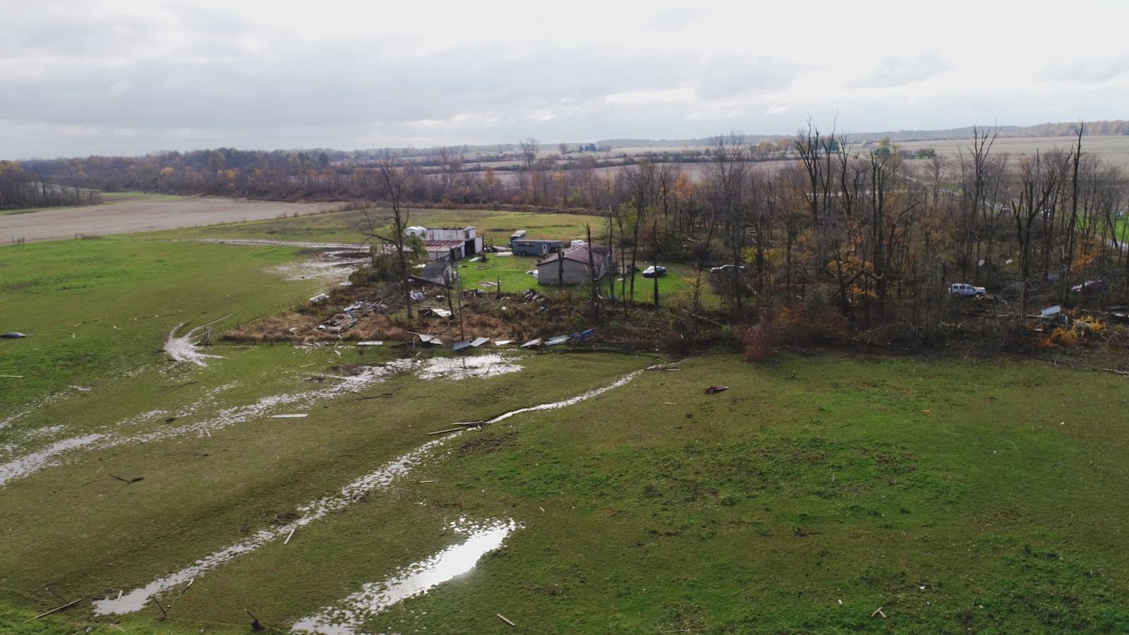 |
| Along 700E just south of 400S in Blackford County. Looking northwest. White lines denote subvorticy tracks common with large multi-vortex tornadoes. Path width here was 600 yards. | Along 700E just south of 400S in Blackford County. Looking west. | Along 700E just south of 400S in Blackford County. Looking southwest. | Along 700E just south of 400S in Blackford County. Looking southeast. |
 |
 |
 |
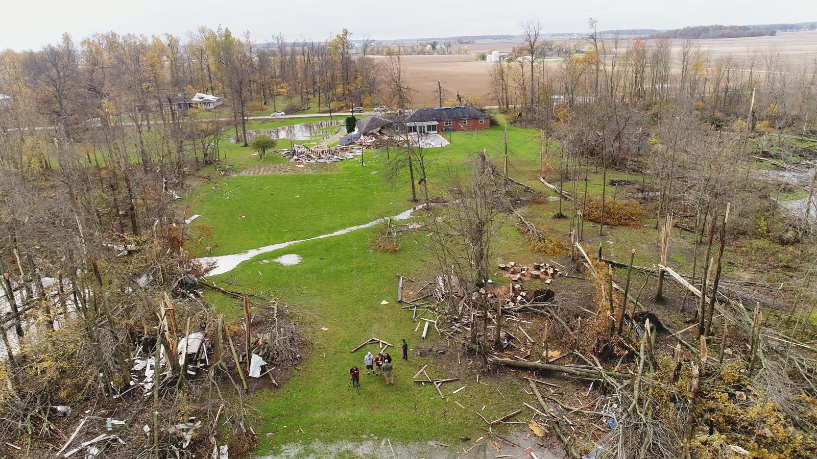 |
| Along 1300N just east of 600E along the Delaware/Blackford County line. Looking west. White lines denote subvorticy tracks common with large multi-vortex tornadoes. Red line denotes parent tornado path. Path width here was 500 yards. | Along 700E 1300N just east of 600E along the Delaware/Blackford County line. Looking east northeast. | Along 1300N just east of 600E along the Delaware/Blackford County line. Looking east. | Along 1300N just east of 600E along the Delaware/Blackford County line. Looking south. |
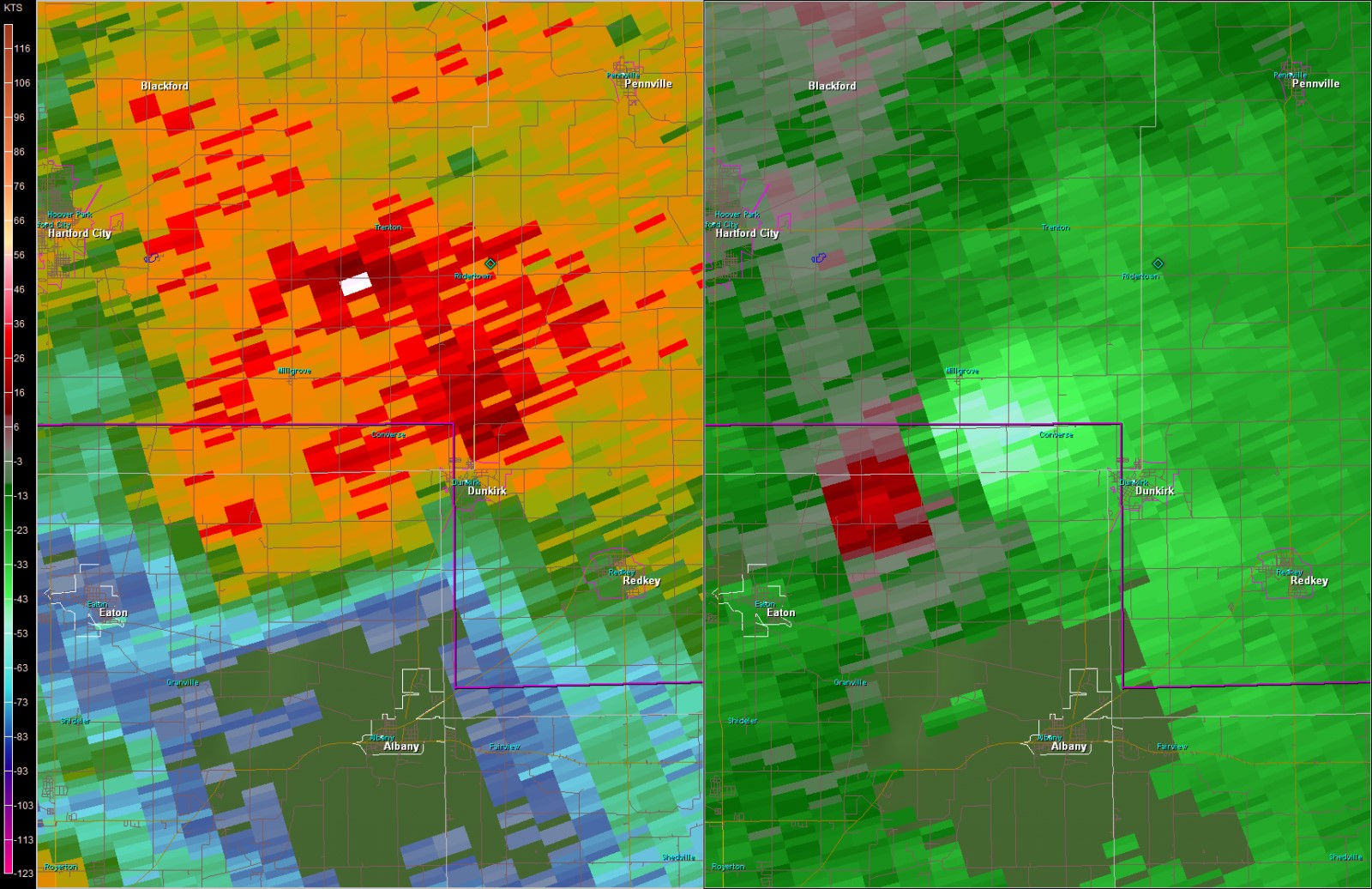
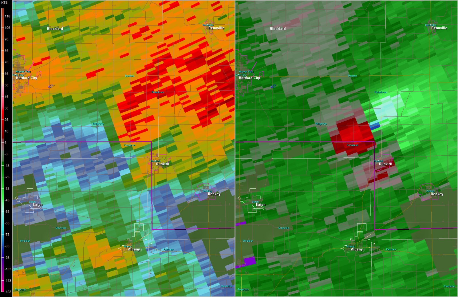
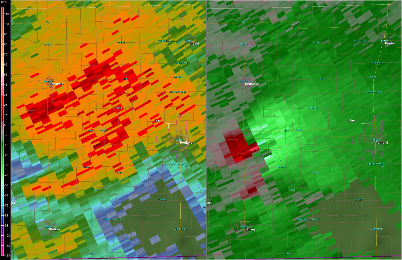
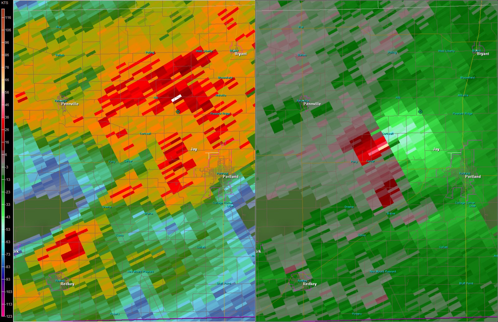
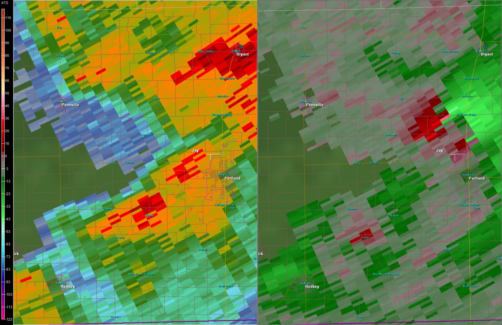
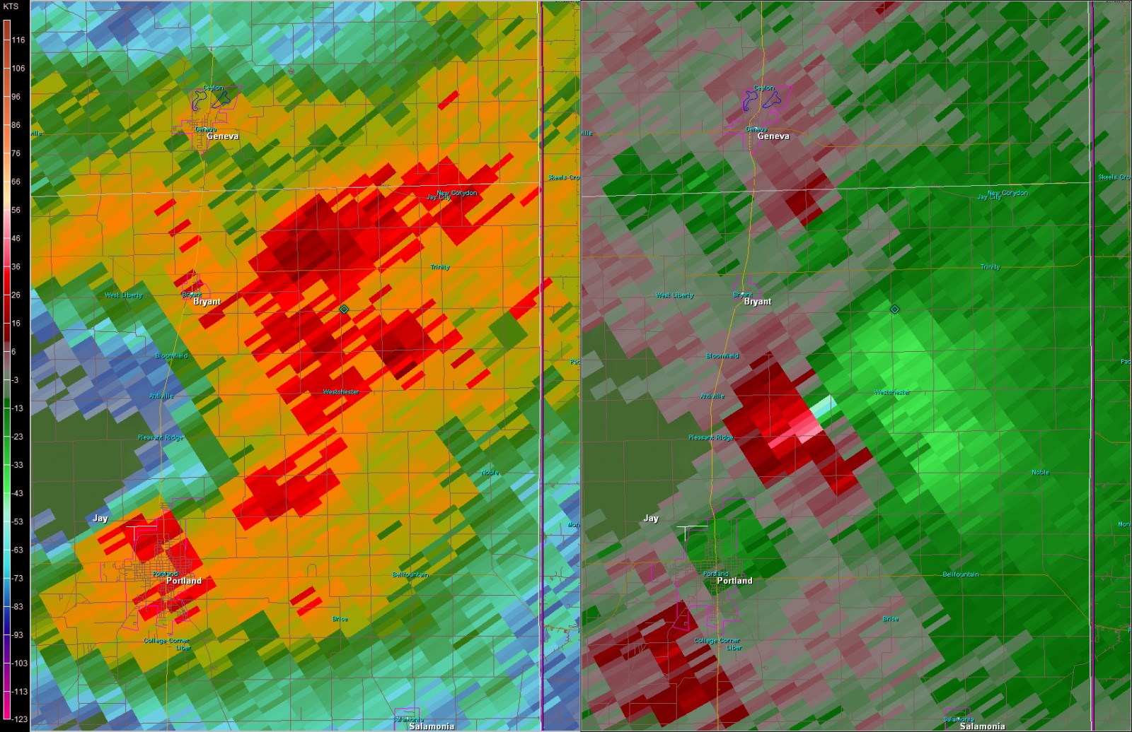
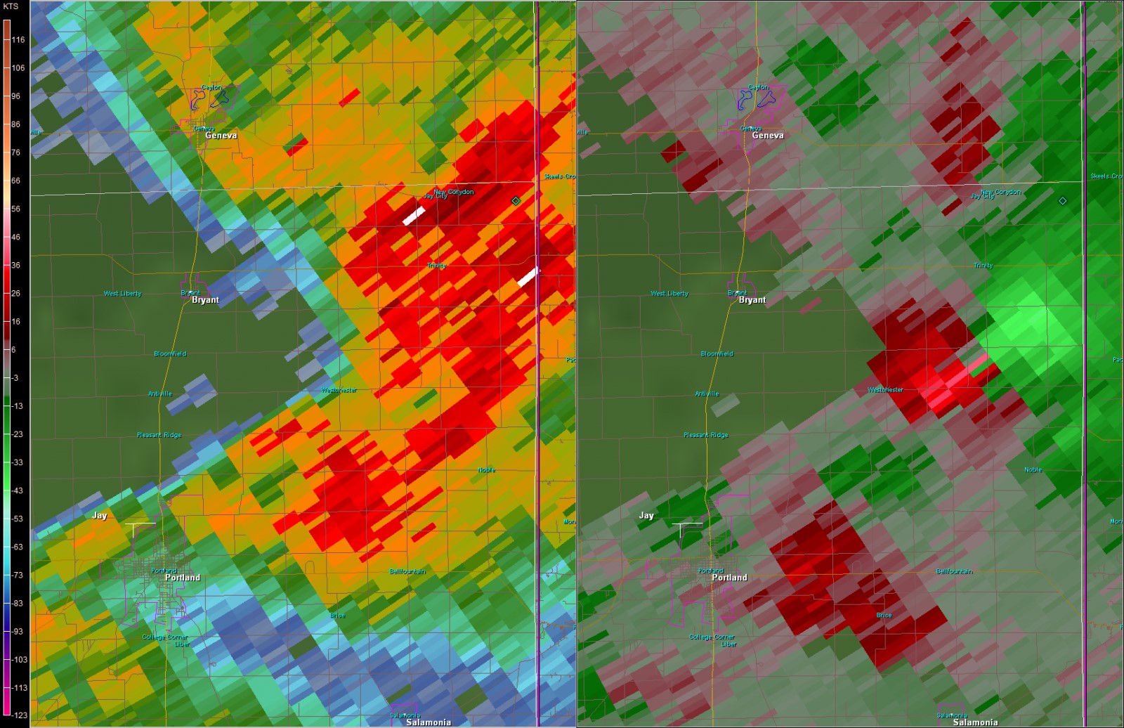
Radar:
Full radar loop is included below showing the evolution of the storms moving through Indiana. Select images of the circulation associated with in Jay county are also included.
 |
 |
 |
 |
| Full Event Radar Loop |
Rotational Couplet at 1:36 pm |
Rotational Couplet at 1:42 pm | 3d Volumetric view of storm |
 |
 |
 |
 |
| Rotational Couplet at 1:48 pm |
Rotational Couplet at 1:54 pm |
Rotational Couplet at 2:00 pm | Rotational Couplet at 2:06 pm |
 |
|||
| Rotational Couplet at 2:12 pm |
|
Storm Reports
PRELIMINARY LOCAL STORM REPORT...SUMMARY
NATIONAL WEATHER SERVICE NORTHERN INDIANA
417 PM EST SUN NOV 5 2017
..TIME... ...EVENT... ...CITY LOCATION... ...LAT.LON...
..DATE... ....MAG.... ..COUNTY LOCATION..ST.. ...SOURCE....
..REMARKS..
0200 PM HEAVY RAIN LEESBURG 41.33N 85.85W
11/05/2017 M2.77 INCH KOSCIUSKO IN PUBLIC
STORM TOTAL SINCE 6AM.
0200 PM HEAVY RAIN MILFORD 41.41N 85.85W
11/05/2017 E2.00 INCH KOSCIUSKO IN PUBLIC
FELL SINCE 9AM.
0150 PM TORNADO 2 W COLLEGE CORNER 40.41N 85.01W
11/05/2017 JAY IN EMERGENCY MNGR
SMALL BARN DESTROYED.
0151 PM FLOOD 2 NE CROMWELL 41.43N 85.58W
11/05/2017 NOBLE IN PUBLIC
WATER RUNNING OVER ROADWAY.
0157 PM TORNADO CONVERSE 40.39N 85.24W
11/05/2017 BLACKFORD IN AMATEUR RADIO
LOCATION CORRECTION. RESIDENTS REPORTED A
SMALL TORNADO TOUCHDOWN; BARN GONE, MISSING
ROOF ON HOUSE.
0150 PM TSTM WND DMG 1 W CENTER 40.44N 85.10W
11/05/2017 JAY IN EMERGENCY MNGR
DAMAGE TO OHIO VALLEY PIPELINE SUBSTATION.
GAS REPORTED LEAKING. PROBABLE TORNADO
IMPACT. TIME ESTIMATED BY RADAR.
0145 PM TSTM WND GST 2 SE NAPOLEON 41.38N 84.10W
11/05/2017 E55 MPH HENRY OH EMERGENCY MNGR
5-7 MINUTES OF STEADY 50-60 MPH WINDS.
0140 PM TORNADO 4 NW COMO 40.42N 85.15W
11/05/2017 JAY IN PUBLIC
BUILDING DAMAGE. SCATTERED DEBRIS IN ALL
DIRECTIONS ACROSS FIELDS. ROOF GONE FROM A
BARN.
0140 PM TORNADO 3 NNE DUNKIRK 40.41N 85.19W
11/05/2017 JAY IN EMERGENCY MNGR
SIGNIFICANT TREE DAMAGE. SOME TREES SHEARED
OFF.
1250 PM TSTM WND DMG 4 ESE BRYAN 41.44N 84.48W
11/05/2017 WILLIAMS OH TRAINED SPOTTER
PICTURES ON FACEBOOK SHOW A BARN LEVELED, AN
OVERTURNED DETACHED GARAGE, AND A LARGE TREE
SPLIT.
1245 PM TSTM WND DMG 3 WNW ELERY 41.31N 84.12W
11/05/2017 HENRY OH EMERGENCY MNGR
TREE DOWN ACROSS ROAD.
1240 PM FLOOD WINONA LAKE 41.22N 85.82W
11/05/2017 KOSCIUSKO IN BROADCAST MEDIA
FLOODED ROADWAYS. POLICE REDIRECTING
TRAFFIC.
1230 PM TSTM WND DMG 1 NW ARCHBOLD 41.52N 84.32W
11/05/2017 FULTON OH TRAINED SPOTTER
ROOF DAMAGE AND DEBRIS ON ROADWAYS REPORTED
ON CR 24, AND MECHANIC ST.
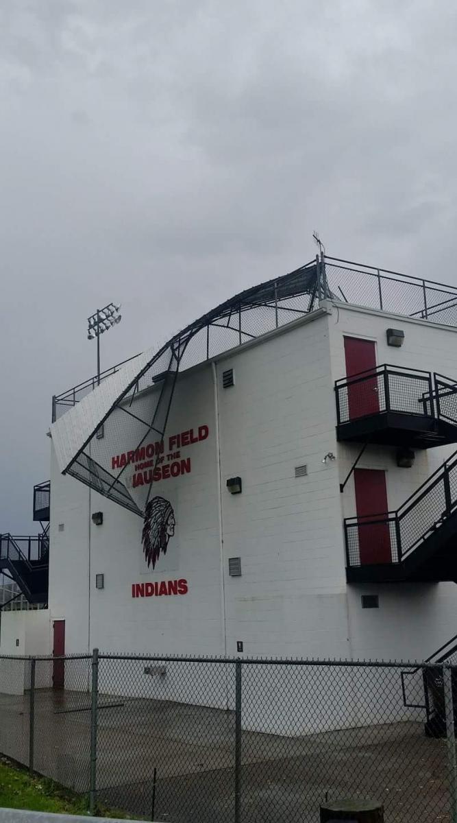
1230 PM TSTM WND DMG 1 ESE WAUSEON 41.55N 84.13W
11/05/2017 FULTON OH PUBLIC
DAMAGE TO THE GRANDSTAND OF THE HIGH SCHOOL
FOOTBALL FIELD.
1039 AM HAIL EDDY 41.54N 85.45W
11/05/2017 M0.88 INCH LAGRANGE IN TRAINED SPOTTER
1224 PM FLOOD 1 S HALLOCK 41.51N 84.56W
11/05/2017 WILLIAMS OH TRAINED SPOTTER
STANDING WATER ON ROADWAY. SMALL TREE DEBRIS
ON NEIGHBORING ROADWAYS.
1223 PM FLOOD 4 ESE WALLEN 41.13N 85.10W
11/05/2017 ALLEN IN AMATEUR RADIO
ESTIMATED 6 INCHES OF WATER ON ROADWAY. AREA
TYPICALLY DOES NOT FLOOD.
1223 PM FLOOD 2 NNW FORT WAYNE 41.10N 85.16W
11/05/2017 ALLEN IN AMATEUR RADIO
ESTIMATED 6 INCHES OF WATER ON ROADWAY. AREA
TYPICALLY DOES NOT FLOOD.
1220 PM TSTM WND GST 3 W RIGDON 40.38N 85.84W
11/05/2017 E60 MPH GRANT IN TRAINED SPOTTER
SPOTTER ESTIMATES 60 MPH WIND GUST.
1215 PM TSTM WND DMG ARCHBOLD 41.52N 84.30W
11/05/2017 FULTON OH TRAINED SPOTTER
ROOF OFF BUILDING NEAR CR24 AND MECHANIC
STREET.
1150 AM TSTM WND DMG STRYKER 41.51N 84.41W
11/05/2017 WILLIAMS OH EMERGENCY MNGR
RESIDENT REPORTED POSSIBLE BRIEF TORNADO
TOUCHDOWN WITH NO DAMAGE. EMERGENCY MANAGER
INDICATES SOME TREES AND POWER LINES DOWN IN
THE COUNTY AS STORMS MOVED THROUGH. TIME
ESTIMATED FROM RADAR.
1145 AM FLASH FLOOD ASHLEY 41.53N 85.06W
11/05/2017 STEUBEN IN EMERGENCY MNGR
ESTIMATED 2-3" OF WATER OVER SR 4, W OF
ASHLEY, WITH TREE BRANCHES FLOATING IN
WATER.
1120 AM HAIL 2 E SALEM CENTER 41.59N 85.11W
11/05/2017 M0.50 INCH STEUBEN IN TRAINED SPOTTER
5 MINUTES OF VERY FLAT, DISC SHAPED HAIL.
CONTINUED FROM 11:13 TO 11:20 AM.
1225 PM TSTM WND DMG 1 NNW NAPOLEON 41.41N 84.13W
11/05/2017 HENRY OH EMERGENCY MNGR
LARGE ROAD SIGN KNOCKED DOWN ALONG US 24.
1045 AM TSTM WND DMG 1 NW ROME CITY 41.50N 85.37W
11/05/2017 NOBLE IN EMERGENCY MNGR
TWO LARGE TREES DOWNED ONTO POWER LINES ON
SPRING BEACH ROAD.
1055 AM FLASH FLOOD NORTH WEBSTER 41.33N 85.70W
11/05/2017 KOSCIUSKO IN NWS EMPLOYEE
UP TO 0.5 FT OF WATER OVER SEVERAL ROADS
DOWNTOWN. EXTREMELY HEAVY RAINFALL.
1110 AM TSTM WND DMG 4 WSW LISBON 41.40N 85.33W
11/05/2017 NOBLE IN EMERGENCY MNGR
CORRECTED LOCATION. TREE DOWN ON ROADWAY.
1115 AM FLOOD 1 NW NAPPANEE 41.46N 86.00W
11/05/2017 ELKHART IN PUBLIC
STANDING WATER OVER MAPLE LANE. UNCERTAIN
ABOUT DEPTH.
Rain Reports
Public Information Statement
National Weather Service Northern Indiana
1007 AM EST Mon Nov 6 2017

...Rainfall Reports Over the past 24 hours...

Location                     Amount    Time/Date       Lat/Lon

...Indiana...

...Adams County...
Decatur 1n                   1.35 in   0700 AM 11/06   40.85N/84.93W
Linn Grove                   1.41 in   0845 AM 11/06   40.66N/85.03W

...Allen County...
2 WNW Leo-cedarville         1.76 in   0800 AM 11/06   41.22N/85.06W
2 WSW Maples                 1.75 in   0700 AM 11/06   40.99N/85.00W
2 ESE Huntertown             1.62 in   0800 AM 11/06   41.21N/85.12W
2 SSW Huntertown             1.50 in   0859 AM 11/06   41.20N/85.19W
3 S Leo-Cedarville           1.43 in   0700 AM 11/06   41.17N/85.03W
1 N Rolling Hills            1.37 in   0630 AM 11/06   41.05N/85.27W
Fort Wayne 4.1 NE            1.32 in   0700 AM 11/06   41.12N/85.09W
2 NE Fort Wayne              1.29 in   0730 AM 11/06   41.10N/85.11W
Woodburn 3n                  1.22 in   0700 AM 11/06   41.16N/84.85W
4 N New Haven                1.14 in   0900 AM 11/06   41.13N/85.03W
2 W Woodburn                 0.97 in   0700 AM 11/06   41.12N/84.91W
Fort Wayne International Ap  0.92 in   0654 AM 11/06   40.98N/85.19W
Woodburn                     0.91 in   0852 AM 11/06   41.14N/84.86W

...Blackford County...
Hartford City                3.15 in   0800 AM 11/06   40.46N/85.37W
(kc9dcr)hartford City 0.3 SS 3.00 in   0700 AM 11/06   40.45N/85.37W
Hartford City 4ESE           2.99 in   0800 AM 11/06   40.44N/85.29W
Hartford City                2.75 in   0700 AM 11/06   40.46N/85.37W

...Cass County...
Young America                0.98 in   0800 AM 11/06   40.57N/86.33W
2 NE Dunkirk                 0.93 in   0800 AM 11/06   40.78N/86.37W
(wa9ttb)galveston 1.0 ESE    0.82 in   0700 AM 11/06   40.57N/86.17W

...De Kalb County...
Auburn                       2.25 in   0600 AM 11/06   41.37N/85.05W
Butler 1SE                   1.55 in   0750 AM 11/06   41.41N/84.85W

...Elkhart County...
1 N Waterford Mills          1.75 in   0500 AM 11/06   41.56N/85.83W
Syracuse 4.4 NNW             1.50 in   0700 AM 11/06   41.48N/85.77W
Goshen Municipal Airport     1.39 in   0653 AM 11/06   41.53N/85.79W
1 S Foraker                  1.37 in   0700 AM 11/06   41.50N/85.92W
2 WSW Goshen                 1.33 in   0700 AM 11/06   41.56N/85.88W
Millersburg                  1.23 in   0700 AM 11/06   41.52N/85.70W
1 WSW Goshen                 1.08 in   0650 AM 11/06   41.57N/85.85W

...Grant County...
3 NW Shamrock Lakes          3.26 in   0700 AM 11/06   40.45N/85.45W
Upland                       2.00 in   0700 AM 11/06   40.47N/85.50W
Fairmount                    1.65 in   0700 AM 11/06   40.42N/85.64W
1 NW Marion                  1.10 in   0730 AM 11/06   40.57N/85.69W
Marion 2n                    1.09 in   0703 AM 11/06   40.58N/85.66W
Hanfield                     1.00 in   0600 AM 11/06   40.60N/85.59W
2 E Jalapa                   0.87 in   0800 AM 11/06   40.62N/85.71W

...Huntington County...
1 ENE Warren                 1.23 in   0630 AM 11/06   40.70N/85.40W
1 ENE Bowerstown             1.28 in   0800 AM 11/06   40.90N/85.41W
3 NE Majenica                1.03 in   0903 AM 11/06   40.82N/85.41W
Huntington                   0.94 in   0700 AM 11/06   40.88N/85.51W
2 NW Warren                  0.81 in   0845 AM 11/06   40.71N/85.45W

...Jay County...
1 SSW Blaine                 2.26 in   0700 AM 11/06   40.39N/85.06W

...Kosciusko County...
Lake Wawasee                 3.86 in   0800 AM 11/06   41.41N/85.70W
Northern Indiana Wfo         3.10 in   0700 AM 11/06   41.36N/85.70W
Leesburg                     2.79 in   0600 AM 11/06   41.33N/85.85W
1 NNW Warsaw                 2.43 in   0700 AM 11/06   41.25N/85.86W
1 N Warsaw                   2.38 in   0600 AM 11/06   41.26N/85.85W
Tippecanoe Lake              2.37 in   0905 AM 11/06   41.33N/85.77W
Milford                      2.31 in   0700 AM 11/06   41.42N/85.85W
James Lake                   2.10 in   0903 AM 11/06   41.31N/85.72W
2 WSW Syracuse               1.76 in   0905 AM 11/06   41.41N/85.79W
1 E Winona Lake              1.29 in   0500 AM 11/06   41.22N/85.79W
2 SW Warsaw                  1.12 in   0902 AM 11/06   41.21N/85.87W
Warsaw 5sw                   0.65 in   0600 AM 11/06   41.17N/85.92W
1 E Claypool                 0.64 in   0642 AM 11/06   41.13N/85.86W

...La Porte County...
1 W La Crosse                0.80 in   0800 AM 11/06   41.32N/86.91W
2 ENE Wanatah                0.53 in   0800 AM 11/06   41.44N/86.83W

...Lagrange County...
1 ENE Lagrange               2.37 in   0400 AM 11/06   41.65N/85.40W
Brushy Prairie               1.94 in   0600 AM 11/06   41.65N/85.23W
2 WNW Elmira                 1.52 in   0700 AM 11/06   41.60N/85.24W

...Marshall County...
Bremen                       1.37 in   0859 AM 11/06   41.44N/86.16W
Plymouth                     1.12 in   0400 AM 11/06   41.34N/86.34W
1 N Twin Lakes               1.06 in   0500 AM 11/06   41.33N/86.36W
Culver                       1.06 in   0700 AM 11/06   41.22N/86.44W
Plymouth                     0.96 in   0900 AM 11/06   41.34N/86.31W
Plymouth                     0.91 in   0851 AM 11/06   41.34N/86.31W

...Miami County...
1 ENE Denver                 1.24 in   0700 AM 11/06   40.88N/86.06W
Peru                         1.19 in   0615 AM 11/06   40.76N/86.07W
Peru                         1.16 in   0830 AM 11/06   40.75N/86.07W
3 W Amboy                    0.93 in   0853 AM 11/06   40.59N/85.98W
1 SSW Grissom Afb            0.90 in   0656 AM 11/06   40.65N/86.15W

...Noble County...
2 E Rome City                2.30 in   0700 AM 11/06   41.50N/85.31W
3 N Kendallville             2.29 in   0700 AM 11/06   41.49N/85.26W
Kendallville                 2.29 in   0700 AM 11/06   41.44N/85.26W
3 NE Avilla                  2.23 in   0857 AM 11/06   41.40N/85.20W
1 E Big Lake                 1.46 in   0851 AM 11/06   41.28N/85.47W

...Pulaski County...
1 SSW Ora                    0.72 in   0830 AM 11/06   41.16N/86.56W

...Starke County...
3 N Brems                    0.90 in   0900 AM 11/06   41.39N/86.71W

...Steuben County...
Metz                         2.34 in   0700 AM 11/06   41.61N/84.84W
Hudson                       2.21 in   0653 AM 11/06   41.53N/85.08W
2 ENE Crooked Lake           1.88 in   0545 AM 11/06   41.70N/84.99W
1 E Hamilton                 1.66 in   0700 AM 11/06   41.53N/84.89W
2 WSW Golden Lake            1.43 in   0600 AM 11/06   41.59N/85.10W
1 W Golden Lake              1.13 in   0800 AM 11/06   41.60N/85.09W
2 W Silver Lake              1.13 in   0815 AM 11/06   41.63N/85.11W
1 SE Crooked Lake            1.05 in   0903 AM 11/06   41.66N/85.02W

...Wabash County...

2 ESE Somerset               1.42 in   0535 AM 11/06   40.66N/85.79W
La Fontaine 1.1 NW           1.24 in   0800 AM 11/06   40.68N/85.74W
Wabash                       1.03 in   0600 AM 11/06   40.80N/85.83W
2 ESE Lagro                  1.01 in   0815 AM 11/06   40.81N/85.68W
Wabash 1.5 SW                0.98 in   0700 AM 11/06   40.78N/85.84W
1 SSE Roann                  0.96 in   0857 AM 11/06   40.89N/85.92W
Urbana                       0.91 in   0600 AM 11/06   40.90N/85.79W
1 SSW Lagro                  0.81 in   0700 AM 11/06   40.82N/85.73W
Wabash                       0.75 in   0830 AM 11/06   40.79N/85.82W
Somerset                     0.63 in   0905 AM 11/06   40.66N/85.81W

...Wells County...
Bluffton                     1.54 in   0700 AM 11/06   40.73N/85.16W
Bluffton                     1.50 in   0845 AM 11/06   40.74N/85.17W
Bluffton--main St. Bridge    1.38 in   0834 AM 11/06   40.74N/85.17W

...White County...
White Cnty Ap                0.89 in   0655 AM 11/06   40.71N/86.77W
1 WNW Indiana Beach          0.77 in   0900 AM 11/06   40.80N/86.79W
Chalmers 5w                  0.50 in   0600 AM 11/06   40.67N/86.95W

...Whitley County...
1 NNW Tri-lakes              1.22 in   0700 AM 11/06   41.24N/85.49W
2 NE Tri-Lakes               1.16 in   0856 AM 11/06   41.25N/85.45W
Tri-lakes                    1.07 in   0904 AM 11/06   41.22N/85.48W
1 ENE Peabody                0.83 in   0600 AM 11/06   41.09N/85.47W

...Michigan...

...Hillsdale County...
1 SSE Montgomery             1.49 in   0800 AM 11/06   41.76N/84.79W

...Ohio...

...Allen County...
1 WSW Slabtown               1.52 in   0700 AM 11/06   40.77N/84.08W
Lima Allen County Airport    1.23 in   0653 AM 11/06   40.71N/84.02W
Bluffton                     1.18 in   0905 AM 11/06   40.89N/83.89W
2 ESE Delphos                0.62 in   0600 AM 11/06   40.83N/84.30W

...Defiance County...
Hicksville                   1.62 in   0845 AM 11/06   41.32N/84.75W
Defiance Memorial Airport    1.60 in   0653 AM 11/06   41.34N/84.43W

...Fulton County...
4 E Fayette                  1.42 in   0900 AM 11/06   41.66N/84.25W
4 NW Tedrow                  1.40 in   0700 AM 11/06   41.65N/84.25W

...Henry County...
3 SE Mcclure                 2.25 in   0700 AM 11/06   41.33N/83.91W
Gallup                       1.63 in   0700 AM 11/06   41.46N/84.15W

...Paulding County...
1 NW Oakwood                 1.15 in   0857 AM 11/06   41.11N/84.40W

...Putnam County...
Kalida                       2.61 in   0850 AM 11/06   40.98N/84.20W
1 W Kalida                   1.21 in   0830 AM 11/06   40.99N/84.23W
Leipsic                      1.06 in   0851 AM 11/06   41.10N/83.99W

...Van Wert County...
1 ENE Van Wert               0.52 in   0904 AM 11/06   40.87N/84.56W

...Williams County...
Alvordton                    1.99 in   0700 AM 11/06   41.67N/84.42W
2 S Pioneer                  1.78 in   0700 AM 11/06   41.64N/84.55W
Bryan 2se                    1.23 in   0800 AM 11/06   41.46N/84.53W
1 WSW Bryan                  1.01 in   0853 AM 11/06   41.46N/84.57W
2 WSW Hallock                0.97 in   0900 AM 11/06   41.51N/84.59W

Observations are collected from a variety of sources with varying
equipment and exposures. We thank all volunteer weather observers
for their dedication. Not all data listed are considered official.


$$
Environment
Thunderstorms need certain atmospheric ingredients to form and become severe. This section review the atmospheric conditions surrounding the severe weather and tornado event that occurred on November 5, 2017. Want to learn more about severe weather and storm spotting? Check out the MetEd training here. For this event, a warm front provided the focus for morning thunderstorms that eventually turned into a bowing segment across Northeast Indiana and Northwest Ohio. Storms also developed across central Indiana and moved into portions of northeast Indiana and northwest Ohio. A cyclic supercell impacted Blackford and Jay county, producing a long tracked tornado and damage along it's path.
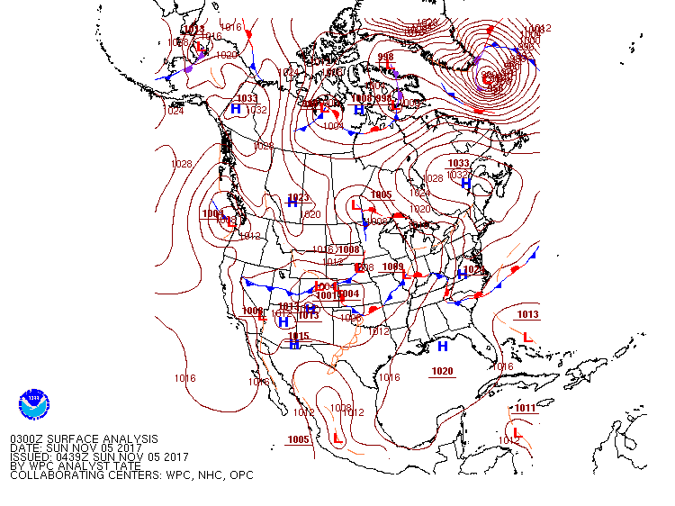
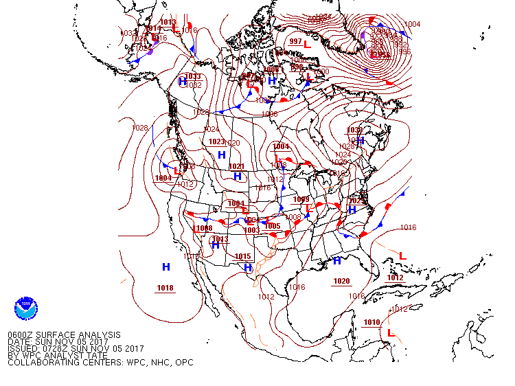
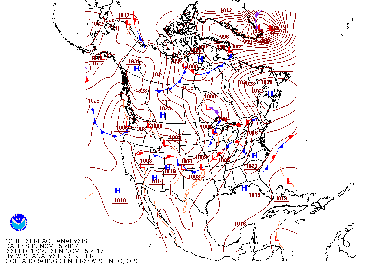
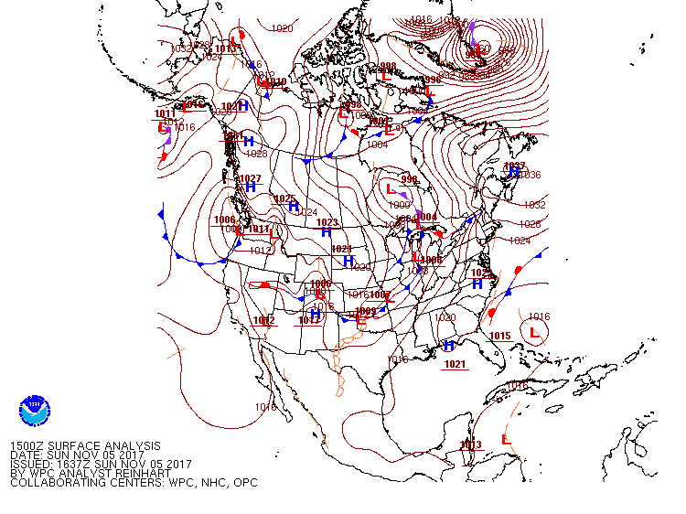
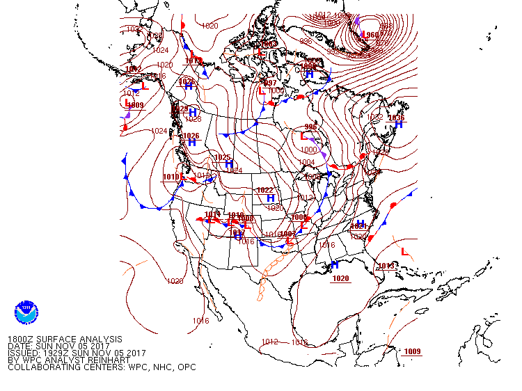
The Warm Front and Warm Sector Airmass: A source of moisture, lift, instability, and wind shear
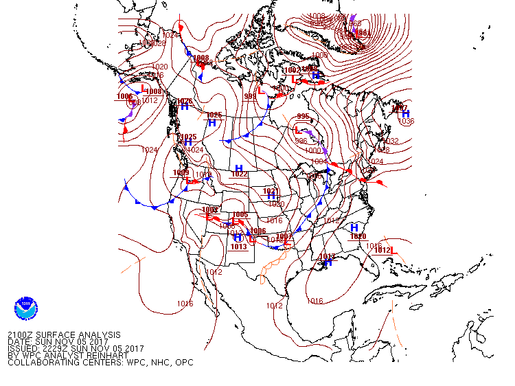
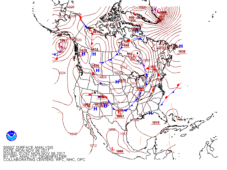
Starting Saturday night and continuing through Sunday afternoon (Nov 5th), a surface warm front lifted northward through Illinois and Indiana. This was in response to a strong low level jet that pumped moisture into the area. Once the warm front reached central northern Indiana (stretching along a line from near Monticello to Fort Wayne, IN) it stalled out.
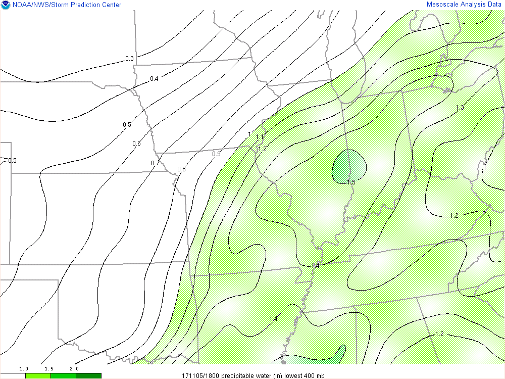
North of the boundary, conditions were poor with dense fog and air temperatures in the 50's. South of the warm front, we had the warm sector. Temperatures in the warm sector were in the low to mid 60's, with similar dewpoints. This airmass provided the necessary moisture and part of the instability we needed for storms to develop. Precipitable water values reached over 1.25 inches, which were roughly 200 percent of normal! Additionally, the lingering frontal boundary provided weak lift and a sufficient source of wind shear-two other important severe weather ingredients.
 |
 |
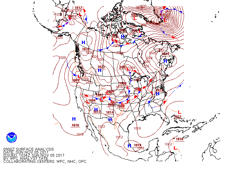 |
| WPC Surface Analysis: 11 pm EDT Nov. 5, 2017 | WPC Surface Analysis: 1 am EST Nov. 5, 2017 | WPC Surface Analysis: 4 am EST Nov. 5, 2017 |
 |
 |
 |
| WPC Surface Analysis: 7 am EST Nov. 5, 2017 | WPC Surface Analysis: 10 am EST Nov. 5, 2017 | WPC Surface Analysis: 1 pm EST Nov. 5, 2017 |
 |
 |
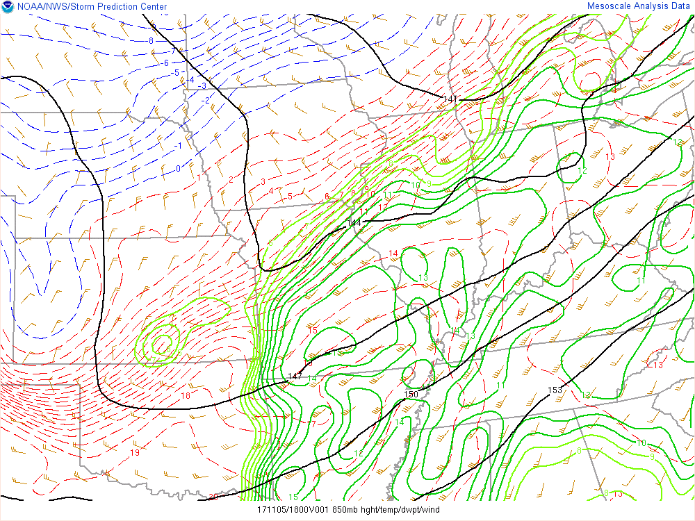 |
| WPC Surface Analysis: 4 pm EST Nov. 5, 2017 | WPC Surface Analysis: 7 pm EST Nov. 5, 2017 | SPC: 1 pm EST. 850mb Analysis showing the winds, moisture, and approaching low level trough. |
 |
 |
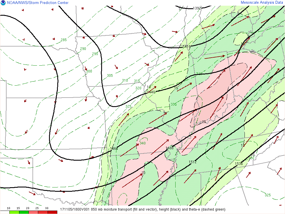 |
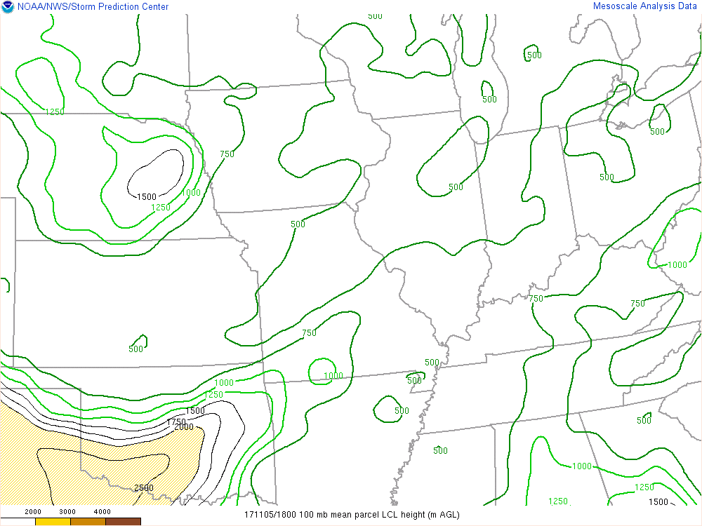
| SPC: 1 pm EST Precipitable Water (in), showing the abundant moisture in the region. | SPC: 1 pm EST Lifted Condensation Level (LCL) heights. Lower levels indicate more moisture, and are more conducive to tornado development. | SPC: 1 pm EST. 850 mb Analysis showing the strong moisture transport and low level jet pumping moisture into our area. |
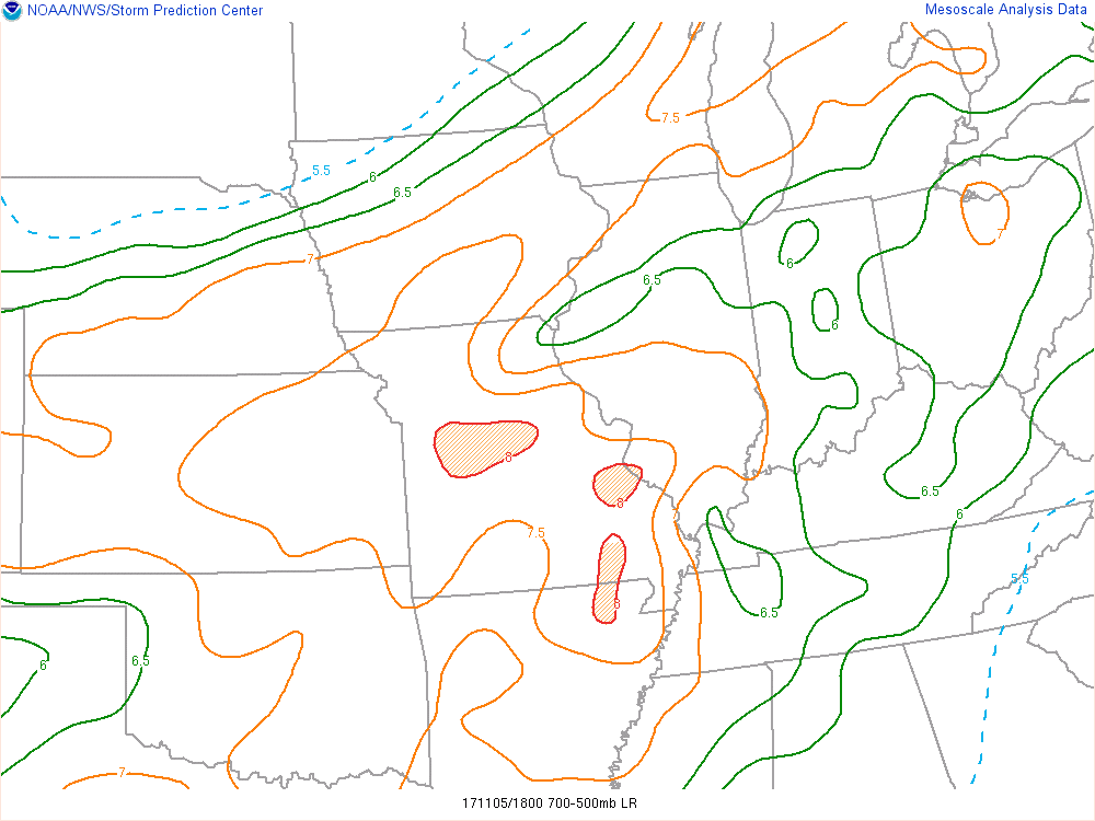
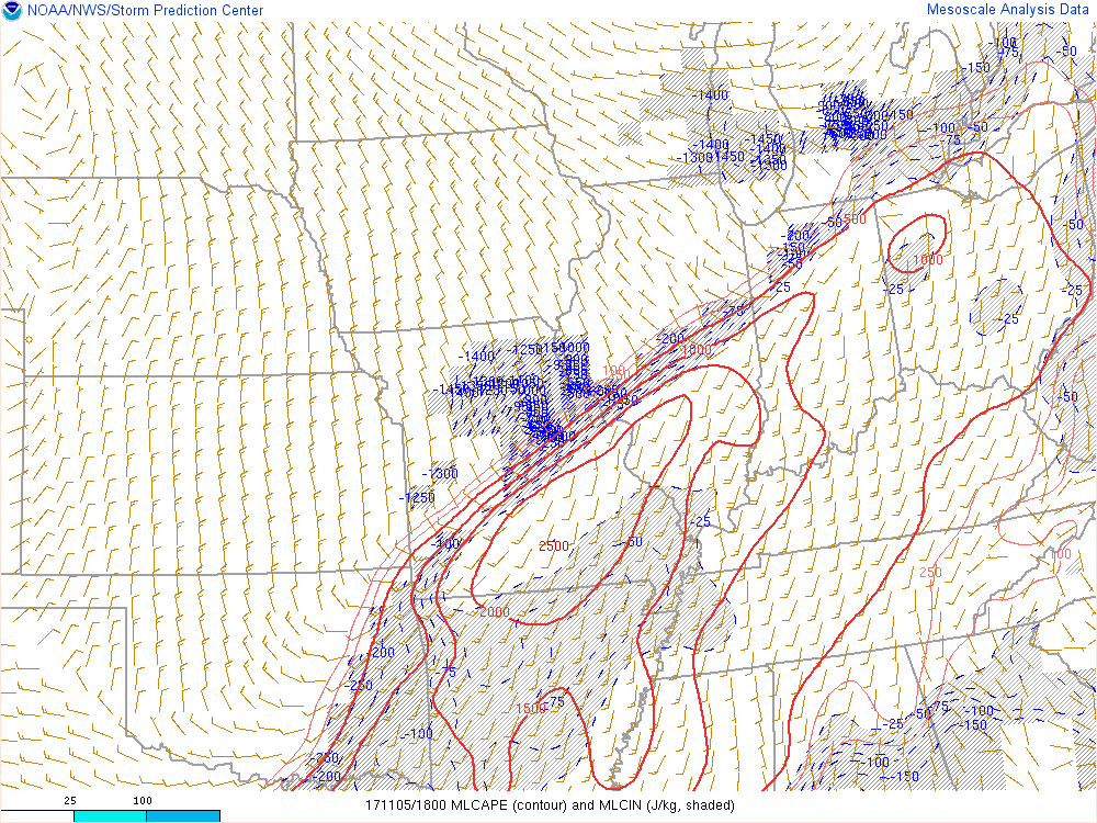
Aloft, an elevated mixed layer was advecting in, as shown by the 700-500 mb lapse rates of 7-7.5 C/KM Sunday morning and afternoon. Unusually modest mixed layer CAPE values of 1000-1500 J/kg accompanying the warm sector air was more than enough for early November (especially when coupled with elevated mixed layer and warm front). Once morning thunderstorms developed, they took advantage of the instability and weaker shear, leading to training storms along the the front with extremely heavy rainfall and flooding. Some areas received over 2-3 inches of rain, including NWS IWX who received 3.1 inches of rain.
 |
 |
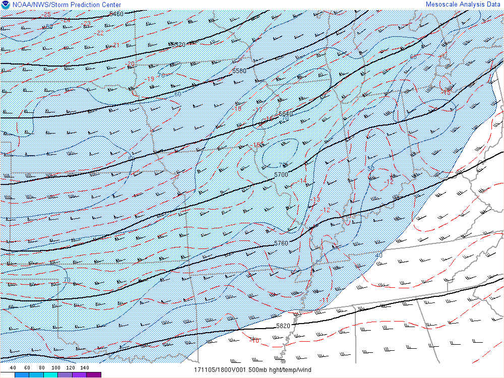 |
| SPC: 1 pm EST. Steeper 700-500 mb Lapse Rates (EML) moving into the area. | SPC: 1 pm EST. Mixed Layer CAPE (J/Kg) | SPC: 1 pm EST. Mid level Trough: 500 mb |
 |
 |
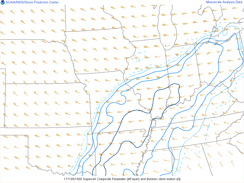 |
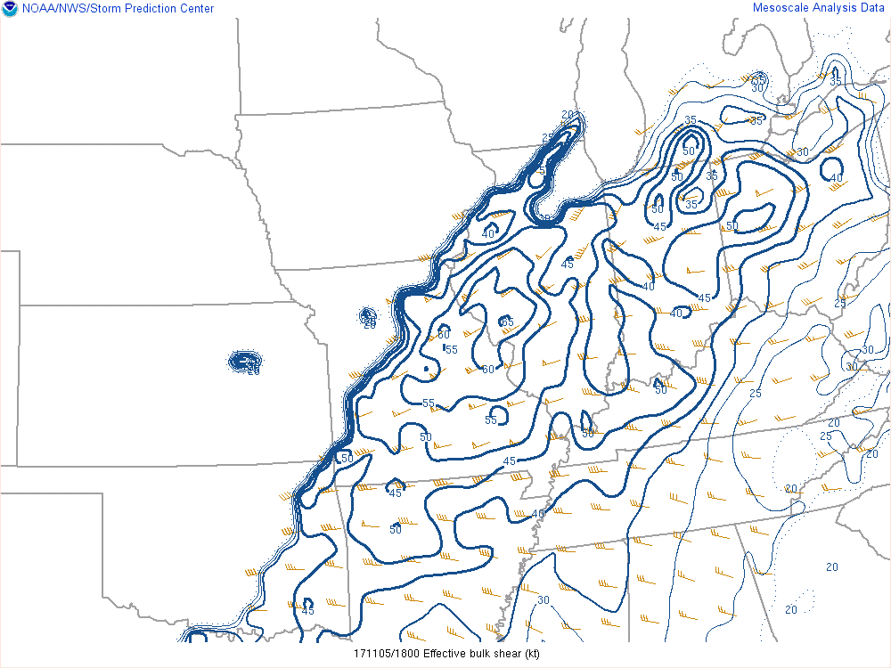
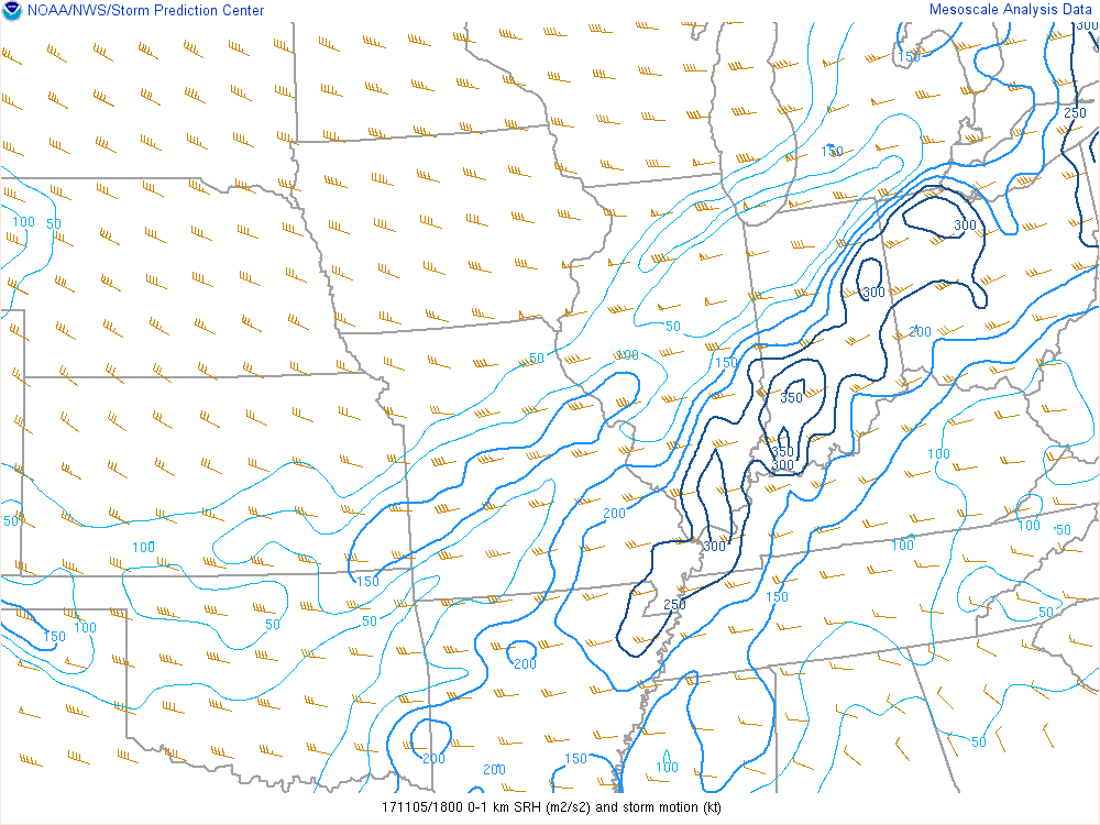
| SPC: 1 pm EST. Bulk Effective Shear (kts) | SPC: 1 pm EST. Storm Relative Helicity. SRH is the potential for cyclonic updraft rotation in right moving supercells. | SPC: 1 pm EST. Supercell Composite (SCP). |
Once some of the stronger wind shear arrived with the cold front, the existing thunderstorms developed into a more organized Quasi-Linear Convective System (QLCS) and began producing more damage across the eastern areas. A cyclic supercell moved out of the IND forecast area across Blackford and Jay Counties, producing a long track tornado. However, despite the fact that the main cold front moved through during the afternoon hours as forecast, the morning convection "hogged" the better initial ingredients-thus preventing the event from becoming even worse than it was. Check out the radar section for some images, and a radar loop.
 |
Media use of NWS Web News Stories is encouraged! Please acknowledge the NWS as the source of any news information accessed from this site. |
|


