Overview
Straight line winds from a line of storms that moved through the area during the morning hours of May 23, 2019 caused widespread damage across the forecast area. Most areas saw winds of around 60 to 70 mph, however some areas saw enhanced wind speTable Propertieseds estimated at 70 to 85 mph. A gustnado may have occurred near Paulding, OH. For more details on the wind damage reports and the public information statement released, select the "storm reports" tab below.
 |
 |
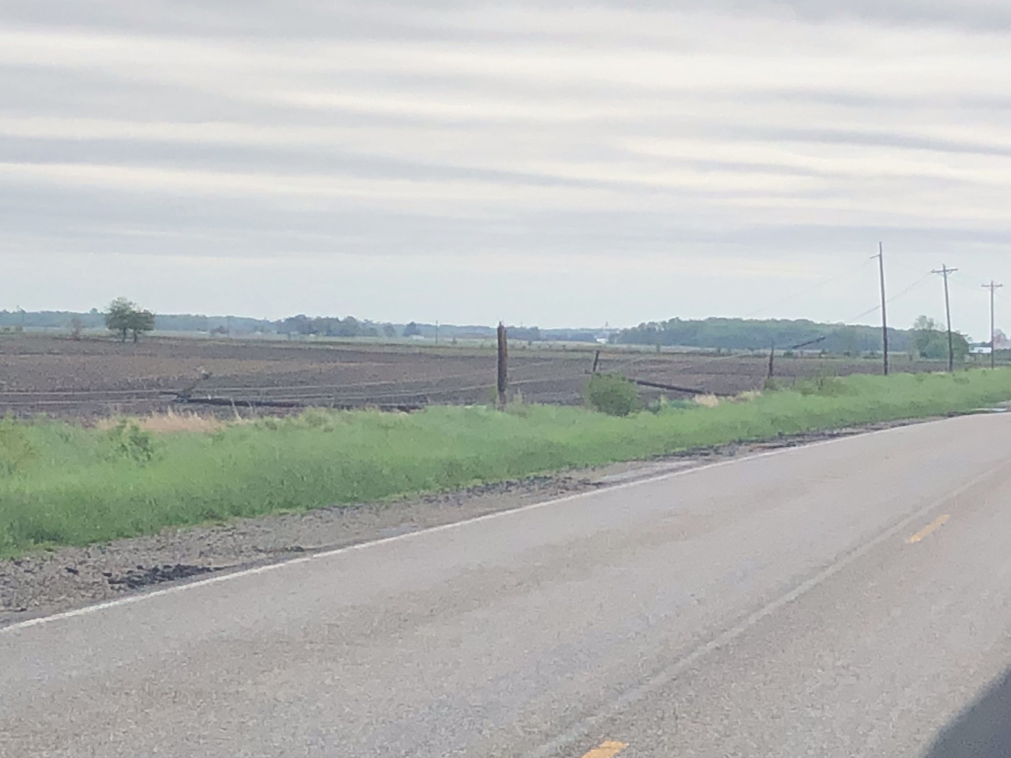
| Storm damage in Leesburg, IN (Megan Dodson, IWX) | Storm damage in Van Wert, OH (Rick McCoy, EMA) |
Thanks to those who sent reports, pictures and videos of the storms and damage. Have something to share? Email it to our webmaster at
w-iwx.webmaster@noaa.gov. Don't forget to write where the pictures were taken. Thank you!
Page last updated: May 25, 2019 4:35 PM EDT
Wind:
Straight line winds with the storm were estimated to be around 60 mph for most locations, but there were some pockets of more extreme winds to around 70 to 80 mph. To read more about straight line winds, go here. Here were some of the reported thunderstorm wind gust measurements or estimates, from both equipment or trained spotters. Note that some of the stronger gusts may not have been captured by the equipment or estimated by spotters.
PUBLIC INFORMATION STATEMENT
NATIONAL WEATHER SERVICE NORTHERN INDIANA
212 PM EDT THU MAY 23 2019

...MEASURED AND ESTIMATED THUNDERSTORM WIND GUSTS MAY 23RD 2019...

LOCATION                     SPEED     TIME/DATE       LAT/LON

...INDIANA...

...ALLEN COUNTY...
2 N ROLLING HILLS            76 MPH    0513 AM 05/23   41.05N/85.26W
1 ESE DUNFEE                 60 MPH    0510 AM 05/23   41.08N/85.32W
2 ENE NINE MILE              56 MPH    0528 AM 05/23   40.99N/85.19W

...GRANT COUNTY...
GRANT COUNTY MUNICIPAL APT   41 MPH    0535 AM 05/23   40.48N/85.68W

...HUNTINGTON COUNTY...
HUNTINGTON                   46 MPH    0515 AM 05/23   40.85N/85.45W

...JAY COUNTY...
PORTLAND                     47 MPH    0555 AM 05/23   40.45N/84.98W

...KOSCIUSKO COUNTY...
MENTONE                      73 MPH    0429 AM 05/23   41.18N/86.04W
2 N NORTH WEBSTER            61 MPH    0446 AM 05/23   41.36N/85.70W
1 S MONOQUET                 60 MPH    0437 AM 05/23   41.28N/85.86W
LEESBURG                     49 MPH    0453 AM 05/23   41.31N/85.72W

...WELLS COUNTY...
BLUFFTON                     70 MPH    0530 AM 05/23   40.74N/85.17W

...MICHIGAN...

...BRANCH COUNTY...
COLDWATER                    41 MPH    0535 AM 05/23   41.92N/85.03W

...OHIO...

...FULTON COUNTY...
WAUSEON                      44 MPH    0620 AM 05/23   41.62N/84.13W

...VAN WERT COUNTY...
VAN WERT                     60 MPH    0610 AM 05/23   40.87N/84.59W

OBSERVATIONS ARE COLLECTED FROM A VARIETY OF SOURCES WITH VARYING
EQUIPMENT AND EXPOSURES. WE THANK ALL VOLUNTEER WEATHER OBSERVERS
FOR THEIR DEDICATION. NOT ALL DATA LISTED ARE CONSIDERED OFFICIAL.
Photos
Wind Damage
Extensive wind damage was observed across the IWX forecast area. Here are some of the photos we received. Thanks to those who sent reports, pictures and videos of the storms and damage. Have something to share? Email it to our webmaster at w-iwx.webmaster@noaa.gov. Be sure to let us know where the photo was taken, and who to give credit to in the event we use the photo on our website, social media, or for educational purposes.
 |
 |
 |
 |
| Damage East of Paulding, OH Source: Bryce Steiner |
Damage to Church in Van Wert Source: Van Wert Co EMA |
Barn Damage in Howe, IN Source: Tyler Sebree ABC57 |
Power Poles Down in Fulton Co, IN Source: Jake Ruff |
 |
 |
 |
 |
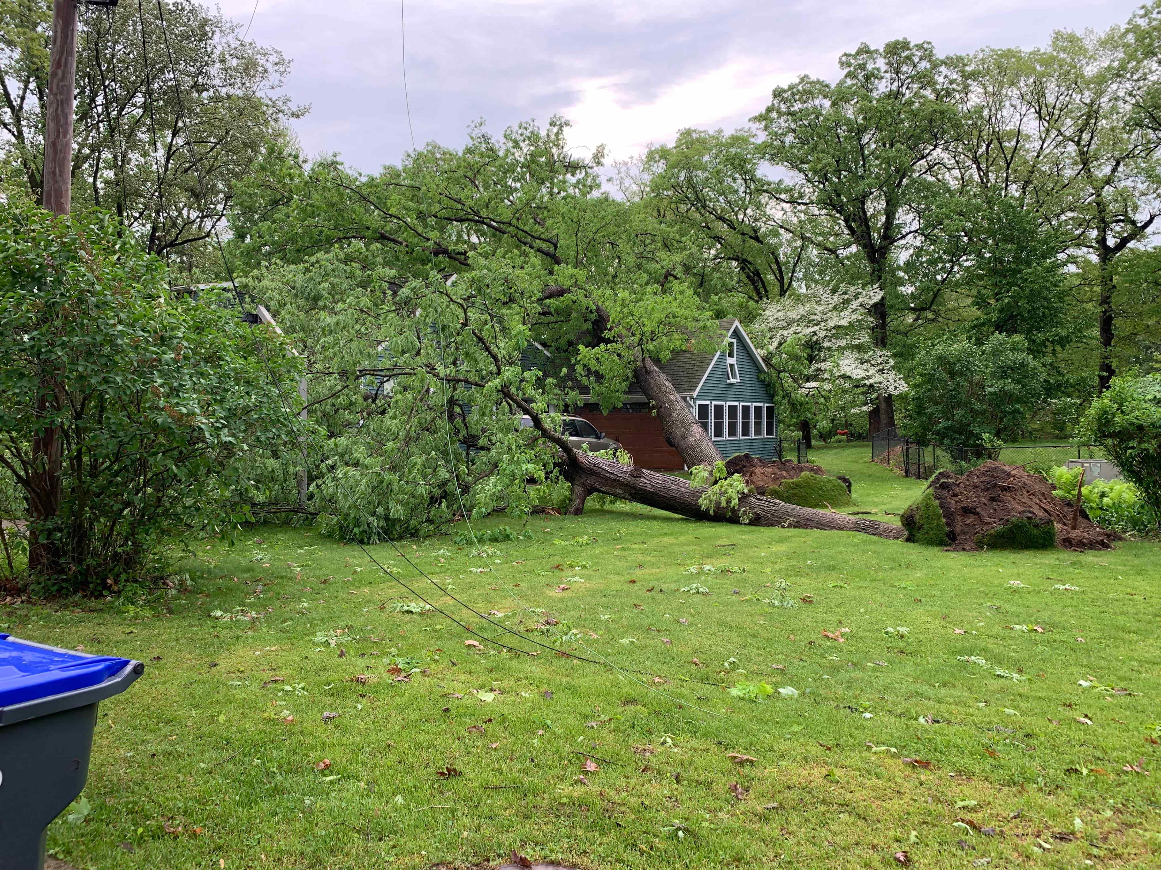
| Tree onto Vehicle in Cass Co, IN Source: Cass County, IN EMA |
Tree down near Dewart Lake Source: Deb Patterson |
Uprooted Tree in Winona Lake Source: Josh Gales |
Tree down in Elkhart Co Source: Nathanael Lusk |
|
 |
 |
 |
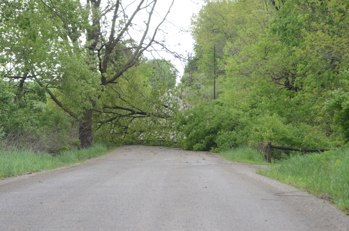
| Tree downed over power lines on Levi Lee Road in Leesburg, IN (Megan Dodson) | Tree downed across Levi Lee Road in Leesburg, IN (Megan Dodson) | Large limb downed on power lines near Leesburg, IN (Megan Dodson) | Tree damage from Argos, IN (Ryan Jackson) |
Radar
This line of storms moved across the entire forecast area. Reflectivity and Velocity data are shown below.
 |
 |
| Radar Loop and Warnings | Velocity Loop |
Storm Reports
SUMMARY

The damage from the storms was determined to be straight line winds, but it is possible that a gustnado formed in a few locations, as
described in the public information statement issued Saturday May 25th, 2019. Individual storm reports of damage submitted to us are
listed below the public information statement.

PUBLIC INFORMATION STATEMENT
NATIONAL WEATHER SERVICE NORTHERN INDIANA
906 AM EDT SAT MAY 25 2019 /806 AM CDT SAT MAY 25 2019/

...NWS DAMAGE SURVEY FOR 05/23/19 THUNDERSTORM WIND EVENT

.OVERVIEW...A LINE OF SEVERE THUNDERSTORMS PRODUCED DAMAGING WINDS
ACROSS A LARGE PART OF NORTHERN INDIANA INTO NORTHWESTERN OHIO.
SEVERAL AREAS OF CONCENTRATED WIND DAMAGE OCCURRED WITH WIND
SPEEDS UP TO 70 MPH RESPONSIBLE FOR MAINLY TREE AND POWER POLE
DAMAGE. A FEW LOCATIONS RECEIVED DAMAGE THAT WARRANTED FURTHER
INVESTIGATION. BELOW IS SOME OF THE PRELIMINARY FINDINGS.

.PAULDING COUNTY OHIO THUNDERSTORM WIND

PEAK WIND /E/:   80-85 MPH
PATH LENGTH /STATUTE/:  0.1 MILES
PATH WIDTH /MAXIMUM/:   25 YARDS
FATALITIES:             0
INJURIES:               0

START DATE:             MAY 23 2019
START TIME:             556 AM EDT
START LOCATION:         5.7 NE PAULDING OH
START LAT/LON:          41.193242/-84.500376

SURVEY_SUMMARY: A LARGE DAIRY COW BARN WAS SEVERELY DAMAGED,
LOSING OVER 75 PERCENT OF ITS ROOF STRUCTURE. NEARBY FARM
BUILDINGS SUFFERED MAINLY METAL ROOF DAMAGE. FARM HANDS REPORTED A
RAPID PRESSURE CHANGE AS THE STORM MOVED OVERHEAD WITH THE BARN
BRING PICKED UP AND DROPPED BACK DOWN. PICTURES, ALONG WITH DRONE
FOOTAGE PROVIDED BY THE PROPERTY OWNER SUGGEST THAT A CONCENTRATED
MICROBURST WAS THE MOST LIKELY CAUSE OF THE DAMAGE, WITH SPEEDS
OF 80 TO 85 MPH IN A NARROW SWATH. SOME OF THE DAMAGE SUGGESTS
THAT A GUSTNADO MAY HAVE FORMED ON THE LEADING EDGE OF THE WINDS
THAT HELPED ENHANCE THE LOCAL DAMAGE.

.OTHER DAMAGE THAT HAS BEEN INVESTIGATED

AREA 1: BETWEEN MIDDLEBURY AND SHIPSHEWANA INDIANA.

DAMAGE OCCURRED TO A LARGE SILO AT THE HERITAGE CREAMERY NEAR THE
ELKHART AND LAGRANGE COUNTY LINE. THIS WAS LIKELY THE RESULT OF
ANOTHER CONCENTRATED AREA OF WIND BETWEEN 70 AND 80 MPH.

AREA 2: HOWE INDIANA

EXTENSIVE DAMAGE OCCURRED IN AND AROUND THE HOWE INDIANA AREA.
WINDS OF 70 TO 80 MPH MAY HAVE OCCURRED IN SOME LOCATIONS,
ENHANCING THE DAMAGE.

IF ADDITIONAL DETAILS ARE DISCOVERED, WE WILL UPDATE THIS SUMMARY.

NOTE:
THE INFORMATION IN THIS STATEMENT IS PRELIMINARY AND SUBJECT TO
CHANGE PENDING FINAL REVIEW OF THE EVENTS AND PUBLICATION IN NWS
STORM DATA.

$$

FISHER
--------------------------------------------------------------------------------------------------------------------------------
PRELIMINARY LOCAL STORM REPORT...SUMMARY
NATIONAL WEATHER SERVICE NORTHERN INDIANA
403 PM EDT THU MAY 23 2019
..TIME... ...EVENT... ...CITY LOCATION... ...LAT.LON...
..DATE... ....MAG.... ..COUNTY LOCATION..ST.. ...SOURCE....
..REMARKS..
0543 AM TSTM WND DMG DECATUR 40.83N 84.93W
05/23/2019 ADAMS IN PUBLIC
1 FT DIAMETER TREE UPROOTED.
0515 AM TSTM WND DMG 1 NNE ROLLING HILLS 41.05N 85.26W
05/23/2019 ALLEN IN TRAINED SPOTTER
TWO SIX INCH DIAMETER LIMBS DOWN, MEASURED
68 MPH GUST HOME WEATHER STATION. NUMEROUS
REPORTS OF POWER OUTAGES.
0513 AM TSTM WND DMG 2 N ROLLING HILLS 41.05N 85.26W
05/23/2019 ALLEN IN TRAINED SPOTTER
SEVERAL LARGE LIMBS DOWNED, MINOR ROOF
DAMAGE FROM LIMBS.
0513 AM TSTM WND GST 2 N ROLLING HILLS 41.05N 85.26W
05/23/2019 M76 MPH ALLEN IN TRAINED SPOTTER
MEASURED FROM ANEMOMETER ON ROOFTOP BEFORE
IT WAS DESTROYED.
0510 AM TSTM WND GST 1 ESE DUNFEE 41.08N 85.32W
05/23/2019 E60 MPH ALLEN IN TRAINED SPOTTER
TIME ESTIMATED BY RADAR.
0528 AM TSTM WND GST 2 ENE NINE MILE 40.99N 85.19W
05/23/2019 M56 MPH ALLEN IN ASOS
FORT WAYNE AIRPORT OFFICIAL OBSERVATION.
0525 AM TSTM WND DMG 1 NE FORT WAYNE 41.08N 85.13W
05/23/2019 ALLEN IN BROADCAST MEDIA
TWO TREES DOWN, ONE INTO A HOUSE AND CARS,
THE OTHER BLOCKING INTERSECTION. NO WORD ON
INJURIES.
0423 AM TSTM WND DMG LOGANSPORT 40.76N 86.36W
05/23/2019 CASS IN NWS EMPLOYEE
1 TO 3 FT DIAMETER TREES DOWNED ON HOUSE ON
HIGH STREET. ROOF DAMAGE FROM THE FALLEN
TREE. TIME ESTIMATED BY RADAR.
0515 AM TSTM WND DMG 1 SSW HAMILTON 41.51N 84.92W
05/23/2019 DE KALB IN PUBLIC
SNAPPED TREE LAYING ON POWER LINE. SR 427
NORTH JUST PAST CR 4 NEAR HAMILTON, IN. TIME
ESTIMATED BY RADAR.
0435 AM TSTM WND DMG 4 SSW BRISTOL 41.67N 85.85W
05/23/2019 ELKHART IN TRAINED SPOTTER
2 FT DIAMETER TREE DOWNED. APPEARS HEALTHY.
SEVERAL 1 FT DIAMETER LIMBS DOWNED AROUND
THE AREA.
0430 AM TSTM WND DMG WAKARUSA 41.54N 86.02W
05/23/2019 ELKHART IN BROADCAST MEDIA
RELAYED REPORT FROM TRAINED SPOTTER. VERY
LARGE TREE DOWN IN TOWN.
0445 AM TSTM WND DMG 1 NW BENTON 41.52N 85.78W
05/23/2019 ELKHART IN PUBLIC
REPORT OF 4-6 INCH DIAMETER TREE LIMBS DOWN.
TIME ESTIMATED FROM RADAR.
0425 AM TSTM WND DMG 1 NNE ROCHESTER 41.07N 86.19W
05/23/2019 FULTON IN TRAINED SPOTTER
STRUCTURAL DAMAGE THE ROOF OF AN AUTO BODY
SHOP.
0420 AM TSTM WND DMG ROCHESTER 41.06N 86.20W
05/23/2019 FULTON IN TRAINED SPOTTER
1 TO 2 FT DIAMETER TREE DOWNED ON A CAR.
NUMEROUS OTHER REPORTS OF TREES AND POWER
LINES DOWNED IN THE AREA.
1201 PM TSTM WND DMG 1 E ROSEBURG 40.52N 85.70W
05/23/2019 GRANT IN TRAINED SPOTTER
TREES AND POWER LINES DOWN IN MARION.
SPOTTER SPECIFICALLY MENTIONED 38TH STREET
WHICH HAD A TREE DOWN ON A HOUSE.
0515 AM TSTM WND DMG 1 E ROSEBURG 40.52N 85.70W
05/23/2019 GRANT IN TRAINED SPOTTER
CORRECTS TIME OF PREVIOUS TSTM WND DMG
REPORT FROM 1 E ROSEBURG. TREES AND POWER
LINES DOWN IN MARION. SPOTTER SPECIFICALLY
MENTIONED 38TH STREET WHICH HAD A TREE DOWN
ON A HOUSE.
0502 AM TSTM WND DMG 2 NW HUNTINGTON 40.90N 85.54W
05/23/2019 HUNTINGTON IN EMERGENCY MNGR
TREES DOWN ON ROADS, TIME ESTIMATED BY
RADAR.
0435 AM TSTM WND DMG MOUNT ETNA 40.74N 85.56W
05/23/2019 HUNTINGTON IN PUBLIC
STRUCTURAL DAMAGE TO A PUMP HOUSE AND
SEVERAL VERY LARGE, HEALTHY 2 TO 4 FT
DIAMETER TREES UPROOTED. SEVERAL 1 TO 2 FT
DIAMETER LIMBS DOWNED.
0512 AM TSTM WND DMG 1 W MOUNT ETNA 40.74N 85.57W
05/23/2019 HUNTINGTON IN EMERGENCY MNGR
REPORT OF A SEMI BLOWN OVER AT INTERSECTION
OF SR9 AND SR124.
0510 AM TSTM WND DMG 1 SSE HUNTINGTON 40.87N 85.50W
05/23/2019 HUNTINGTON IN EMERGENCY MNGR
REPORT OF TREE DOWN AND ESTIMATED 55-60 MPH
WINDS IN CITY OF HUNTINGTON.
0509 AM TSTM WND DMG 1 NNW ROANOKE 40.97N 85.38W
05/23/2019 HUNTINGTON IN EMERGENCY MNGR
TREES DOWN, TIME ESTIMATED BY RADAR.
0503 AM TSTM WND DMG MOUNT ETNA 40.74N 85.56W
05/23/2019 HUNTINGTON IN EMERGENCY MNGR
MINOR STRUCTURAL DAMAGE TO A CHURCH, AND TO
THE MT ETNA FIRE DEPARTMENT NEXT DOOR, TIME
ESTIMATED BY RADAR.
0502 AM TSTM WND DMG 2 ENE GOBLESVILLE 41.00N 85.47W
05/23/2019 HUNTINGTON IN TRAINED SPOTTER
ALONG SR 9 NEAR THE WHITLEY AND HUNTINGTON
COUNTY LINE. LARGE TREE SNAPPED IN
HALF-ABOUT 1 TO 2 FT DIAMETER, DOWNED ON A
HOUSE. SEVERAL LARGE LIMBS ALSO SCATTERED
ABOUT, SOME ON THE ROOF. MINOR ROOF DAMAGE.
0440 AM TSTM WND DMG NORTH WEBSTER 41.33N 85.70W
05/23/2019 KOSCIUSKO IN NWS EMPLOYEE
TREE DOWN ACROSS HIGHWAY 13 IN NORTH
WEBSTER, TIME ESTIMATED BY RADAR.
0439 AM LIGHTNING 1 SSW CLUNETTE 41.30N 85.93W
05/23/2019 KOSCIUSKO IN PUBLIC
TREE DAMAGE DUE TO LIGHTNING. TIME ESTIMATED
FROM RADAR.
0437 AM TSTM WND DMG PALESTINE 41.18N 85.95W
05/23/2019 KOSCIUSKO IN NWS EMPLOYEE
SEVERAL LARGE TREES DOWNED OR SNAPPED IN
HALF AT A RESIDENCE. ONE TREE FELL INTO THE
HOUSE AND CAUSED ROOF DAMAGE. TREES ROUGHLY
1 TO 3 FEET IN DIAMETER. POWER LINES WERE
ALSO DOWNED NEARBY.
0437 AM TSTM WND DMG 2 ENE LEESBURG 41.34N 85.82W
05/23/2019 KOSCIUSKO IN NWS EMPLOYEE
2 FT DIAMETER TREE LIMB DOWNED ON A
POWERLINE, APPEARS MOSTLY HEALTHY.
0437 AM TSTM WND DMG MONOQUET 41.28N 85.86W
05/23/2019 KOSCIUSKO IN NWS EMPLOYEE
1FT DIAMETER BLUE SPRUCE TREE PARTIALLY
UPROOTED. SAME LOCATION AS EARLIER 60 MPH
REPORT.
0437 AM TSTM WND DMG 1 NE WINONA LAKE 41.23N 85.80W
05/23/2019 KOSCIUSKO IN FIRE DEPT/RESCUE
ROOF DAMAGE TO THE ECONOMY LODGE ON THE EAST
SIDE OF WARSAW. NUMEROUS TREES DOWNED AROUND
WINONA LAKE AND WARSAW.
0437 AM TSTM WND GST 1 S MONOQUET 41.28N 85.86W
05/23/2019 E60 MPH KOSCIUSKO IN NWS EMPLOYEE
.
0429 AM TSTM WND GST MENTONE 41.18N 86.04W
05/23/2019 M73 MPH KOSCIUSKO IN MESONET
.
0446 AM TSTM WND GST 2 N NORTH WEBSTER 41.36N 85.70W
05/23/2019 M61 MPH KOSCIUSKO IN OFFICIAL NWS OBS
AUTOMATED WEATHER STATION MEASUREMENT.
0445 AM TSTM WND DMG 1 NNW WINONA LAKE 41.23N 85.82W
05/23/2019 KOSCIUSKO IN PUBLIC
BRANCHES DOWN AND A CHIMNEY BLOWN OFF ROOF.
0440 AM TSTM WND DMG BIG BARBEE LAKE 41.29N 85.70W
05/23/2019 KOSCIUSKO IN NWS EMPLOYEE
TREE DOWN AND BLOCKING NORTHBOUND HIGHWAY
13, TIME ESTIMATED BY RADAR.
0455 AM TSTM WND DMG 1 NNE HOWE 41.74N 85.41W
05/23/2019 LAGRANGE IN BROADCAST MEDIA
BARN DESTROYED ON N100 E BETWEEN E 600 N AND
E 700 N.
0455 AM TSTM WND DMG 2 WSW HOWE 41.71N 85.45W
05/23/2019 LAGRANGE IN BROADCAST MEDIA
NUMEROUS TREES SNAPPED OR UPROOTED JUST WEST
OF HOWE ALONG W 450 N.
0450 AM TSTM WND DMG 2 W TOPEKA 41.54N 85.58W
05/23/2019 LAGRANGE IN PUBLIC
A FEW TREES AND POWER LINES DOWNED. TIME
ESTIMATED BY RADAR.
0448 AM TSTM WND DMG 3 E MIDDLEBURY 41.68N 85.64W
05/23/2019 LAGRANGE IN TRAINED SPOTTER
LARGE SILO OR TALL STORAGE BIN DOWNED AT
HERITAGE CREAMERY. TIME ESTIMATED BY RADAR.
0500 AM TSTM WND DMG HOWE 41.72N 85.43W
05/23/2019 LAGRANGE IN BROADCAST MEDIA
SIGNIFICANT TREE AND POWER LINE DAMAGE IN
AND AROUND HOWE. POWER OUT.
0428 AM TSTM WND DMG 2 WNW ETNA GREEN 41.29N 86.08W
05/23/2019 MARSHALL IN PUBLIC
TREE DOWN ON US 30 EAST OF BOURBON.
0420 AM TSTM WND DMG ARGOS 41.24N 86.25W
05/23/2019 MARSHALL IN PUBLIC
SIGNIFICANT TREE DAMAGE IN AREA. LARGE WOOD
PLAYPEN TOSSED SEVERAL YARDS.
0420 AM TSTM WND DMG 3 NNE TALMA 41.19N 86.30W
05/23/2019 MARSHALL IN PUBLIC
6-12 INCH DIAMETER TREE LIMBS DOWN ON A
HOUSE.
0503 AM TSTM WND DMG WOLCOTTVILLE 41.53N 85.37W
05/23/2019 NOBLE IN BROADCAST MEDIA
RELAYED PUBLIC REPORT OF LOTS OF TREES DOWN
IN WOLCOTTVILLE AND POWER OUT. TIME
ESTIMATED FROM RADAR.
0420 AM TSTM WND DMG 3 N WOODLAND 41.61N 86.18W
05/23/2019 ST. JOSEPH IN BROADCAST MEDIA
LARGE TREES DOWN AT THE FERRISVILLE CEMETERY
AT THE CORNER OF KERN AND 331. POWERLINES
ALSO DOWNED. PER WSBT.
0415 AM TSTM WND DMG 1 N GULIVOIRE PARK 41.63N 86.24W
05/23/2019 ST. JOSEPH IN TRAINED SPOTTER
2 FT DIAMETER TREE UPROOTED, FELL AND
CRUSHED THREE CARS. TIME ESTIMATED BY RADAR.
0420 AM TSTM WND DMG 2 S MISHAWAKA 41.64N 86.18W
05/23/2019 ST. JOSEPH IN TRAINED SPOTTER
TREES AND POWER LINES DOWN AROUND EAST SIDE
OF MISHAWAKA ALONG US 331 AND BREMEN HWY.
0420 AM TSTM WND DMG 1 S GRANGER 41.72N 86.14W
05/23/2019 ST. JOSEPH IN BROADCAST MEDIA
LARGE TREE ACROSS THE ROAD AT US 331 AND
CLEVELAND ROAD. TIME ESTIMATED BY RADAR.
0415 AM TSTM WND DMG LAKEVILLE 41.53N 86.27W
05/23/2019 ST. JOSEPH IN PUBLIC
TWO 1 TO 2 FT DIAMETER HEALTHY TREES DOWNED.
RELAYED VIA ABC57.
0515 AM TSTM WND DMG 1 S ANGOLA 41.62N 85.00W
05/23/2019 STEUBEN IN EMERGENCY MNGR
EMERGENCY MANAGER REPORTS LIMBS, TREES AND
POWER LINES DOWN COUNTY WIDE. TIME ESTIMATED
FROM RADAR.
0514 AM TSTM WND DMG ORLAND 41.73N 85.17W
05/23/2019 STEUBEN IN BROADCAST MEDIA
POWER LINES AND TREES DOWN AND TREES
UPROOTED AND ROADS CLOSED. ORLAND TO
PLEASANT LAKE AREA.
0530 AM TSTM WND GST BLUFFTON 40.74N 85.17W
05/23/2019 M70 MPH WELLS IN TRAINED SPOTTER
0538 AM TSTM WND DMG BLUFFTON 40.74N 85.17W
05/23/2019 WELLS IN TRAINED SPOTTER
70 MPH WINDS ESTIMATED WITH POWER OUTAGES
AND TREES DOWN AROUND TOWN. TIME ESTIMATED
FROM RADAR.
0455 AM TSTM WND DMG 1 NW COLUMBIA CITY 41.16N 85.49W
05/23/2019 WHITLEY IN NWS EMPLOYEE
CORRECTS PREVIOUS TSTM WND DMG REPORT FROM 1
NW COLUMBIA CITY. ESTIMATED 6-10 INCH TREE
DIAMETER BRANCH DOWN NEAR LINE ST AND NORTH
ST (COLUMBIA CITY). LOOKS LIKE SOME GUTTER
AND SHINGLE DAMAGE TO HOME. CLEANUP
UNDERWAY. TIME ESTIMATED BY RADAR.
0448 AM TSTM WND DMG 1 S WASHINGTON CENTER 41.03N 85.51W
05/23/2019 WHITLEY IN PUBLIC
ANCHORED PLAYSET FLIPPED UPSIDE DOWN.
ANCHORED TRAMPOLINE THROWN 200 FT INTO TREE
LINE. SMALL LIMBS DOWN.
0523 AM TSTM WND DMG COLDWATER 41.94N 85.00W
05/23/2019 BRANCH MI BROADCAST MEDIA
TREES UPROOTED, BLOWN OVER AND POWER LINES
DOWN. RELAYED VIA PUBLIC.
0540 AM TSTM WND DMG HILLSDALE 41.93N 84.64W
05/23/2019 HILLSDALE MI PUBLIC
SEVERAL LARGE TREES REPORTED SNAPPED OR
UPROOTED AROUND HILLSDALE. SOME POWER LINES
DOWNED.
0537 AM TSTM WND DMG READING 41.84N 84.75W
05/23/2019 HILLSDALE MI PUBLIC
POWER LINES REPORTED DOWN. TIME ESTIMATED
FROM RADAR.
0501 AM TSTM WND DMG COLON 41.96N 85.32W
05/23/2019 ST. JOSEPH MI TRAINED SPOTTER
SEVERAL HEALTHY, LARGE TREES UPROOTED OR
SNAPPED. AROUND 1 TO 2 FT DIAMETER.
TRAMPOLINE MANGLED AND BLOWN DOWN THE ROAD.
0530 AM TSTM WND DMG CONSTANTINE 41.84N 85.67W
05/23/2019 ST. JOSEPH MI BROADCAST MEDIA
TREES AND WIRES DOWN IN ST JOSEPH COUNTY.
SPECIFICALLY, AT CLEVELAND ROAD AND FIR
ROAD, ASH ROAD AND DUNN ROAD, RILEY ROAD AT
OAK ROAD, AND MERRIFIELD DRIVE AND
SPRINGMILL DRIVE. AS WELL AS NEAR 131. TIME
ESTIMATED BY RADAR.
0430 AM TSTM WND DMG STURGIS 41.80N 85.42W
05/23/2019 ST. JOSEPH MI TRAINED SPOTTER
CORRECTS PREVIOUS TSTM WND DMG REPORT FROM
STURGIS. TREES AND POWERLINES DOWN IN THE
STURGIS AREA.
0600 AM TSTM WND DMG DEFIANCE 41.28N 84.36W
05/23/2019 DEFIANCE OH EMERGENCY MNGR
WIND DAMAGE WAS LOCATED AROUND DEFIANCE OH
COUNTY. WINDS PICKED UP A SET OF BLEACHERS,
TOOK OUT A FENCE AND DRPOPED THEM ON THE
FOOTBALL FIELD AT AYERSVILLE HIGH SCHOOL.
TREE ON SR 249. TREE ON HOUSE ON HOPKINS ST.
A LARGE TREE FELL ON A CONSTRUCTION TRUCK IN
AYERSVILLE. HARDING ROAD HAS POWER LINES
DOWN.
0549 AM TSTM WND DMG 1 NE ARCHBOLD 41.53N 84.29W
05/23/2019 FULTON OH TRAINED SPOTTER
LARGE TREE DOWNED ACROSS CR 22 BETWEEN ROADS
D AND E.
0620 AM TSTM WND DMG NAPOLEON 41.40N 84.13W
05/23/2019 HENRY OH EMERGENCY MNGR
CORRECTS TIME OF PREVIOUS TSTM WND DMG
REPORT FROM NAPOLEON. TREES DOWN IN AND
AROUND HENRY COUNTY.
0609 AM TSTM WND DMG NAPOLEON 41.40N 84.13W
05/23/2019 HENRY OH AMATEUR RADIO
1 FT DIAMETER HEALTHY TREE LIMBE DOWNED.
0554 AM TSTM WND DMG 5 NNW CHARLOE 41.19N 84.46W
05/23/2019 PAULDING OH EMERGENCY MNGR
EM REPORTS LARGE LIMBS AND TREES DOWN ACROSS
THE COUNTY. SEVERAL POWER POLES DOWN AND 2
BARNS DAMAGED ON SR111 BETWEEN COUNTY ROADS
133 AND 139.
0555 AM TSTM WND DMG 2 N GROVER HILL 41.04N 84.48W
05/23/2019 PAULDING OH EMERGENCY MNGR
SEMI BLOWN OVER ON SR 637 NORTH OF GROVER
HILL. DRIVER TRAPPED. NO WORD ON INJURIES.
0628 AM TSTM WND DMG LEIPSIC 41.10N 83.99W
05/23/2019 PUTNAM OH EMERGENCY MNGR
POWER LINES DOWN IN LEIPSIC. REPORT OF
SCHOOLS DELAYING DUE TO POWER OUTAGES.
0553 AM TSTM WND DMG VAN WERT 40.86N 84.58W
05/23/2019 VAN WERT OH EMERGENCY MNGR
TREE FELL INTO A CAR, AND STRUCTURAL DAMAGE
REPORTED IN TOWN. NUMEROUS TREES DOWNED AND
SOME ON POWER LINES.
0610 AM TSTM WND GST VAN WERT 40.87N 84.59W
05/23/2019 M60 MPH VAN WERT OH MESONET
MESONET STATION FW4002 VAN WERT.
0606 AM TSTM WND DMG VAN WERT 40.87N 84.58W
05/23/2019 VAN WERT OH EMERGENCY MNGR
A NUMBER OF TREES REPORTED DOWN AT NUMEROUS
LOCATIONS IN THE CITY OF VAN WERT.
0549 AM TSTM WND DMG 2 N CONVOY 40.94N 84.71W
05/23/2019 VAN WERT OH EMERGENCY MNGR
SEMI BLOWN OVER ON US 30 JUST WEST OF STATE
RT 49.
&&
MCD
Environment
Thunderstorms rapidly formed across northern Illinois Wednesday evening. These storms consolidated and formed a large convective complex across east central Illinois. Initially, conditions were relatively stable across northern Indiana, southern Lower Michigan, and northwest Ohio in the evening. Late Wednesday night into early Thursday morning, a low level jet allowed the greater elevated instability across Illinois to shift eastward. The combination of moderate instability and strong wind shear allowed this convective complex to survive across all of the forecast area with several reports of wind damage and 60 to 75 mph wind gusts.
From a synoptic standpoint, conditions were favorable for storm development. The local area was located in a favorable proximity to the upper level jet across the Great Lakes region. In addition, mid level winds were strong allowing for storms to become organized and the severe threat long lasting. Despite these storms occurring during a generally unfavorable time for severe weather late in the night, higher dew point air near the surface was also advecting northward which was a favorable factor for maintenance of these thunderstorms.
 |
 |
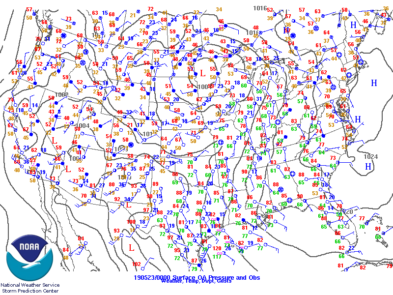 |
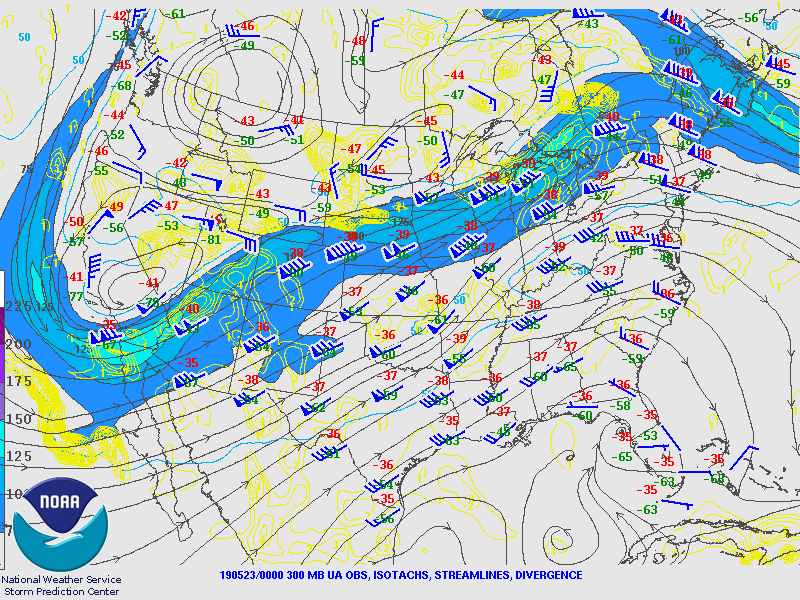
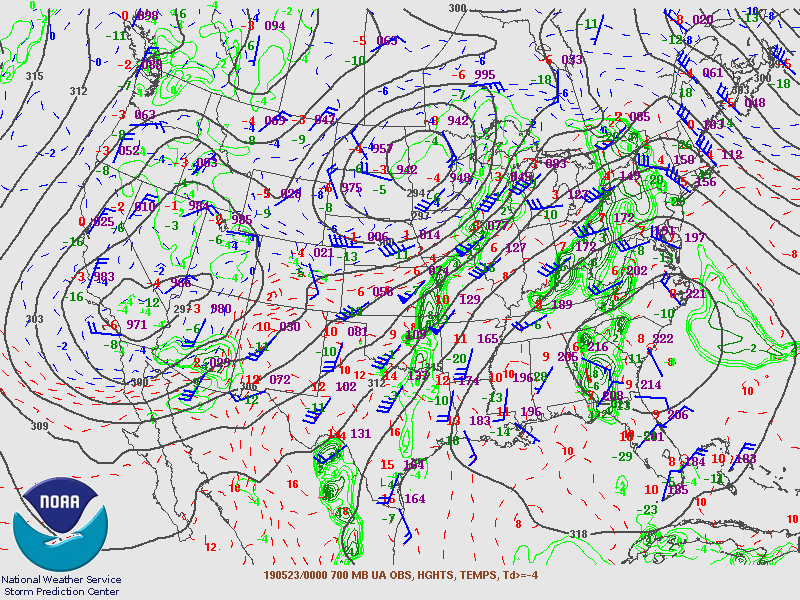
| Figure 1: 300 mb analysis 5/22/19 8pm EDT | Figure 2: 700 mb analysis 5/22/19 8pm EDT | Figure 3: Surface analysis 5/22/19 8pm EDT |
Initially northern Indiana, southern Lower Michigan, and northwest Ohio were relatively stable during the evening hours. The following images show how quickly elevated instability surged northward during the overnight. This instability was aided by strong low level moisture transport.
 |
 |
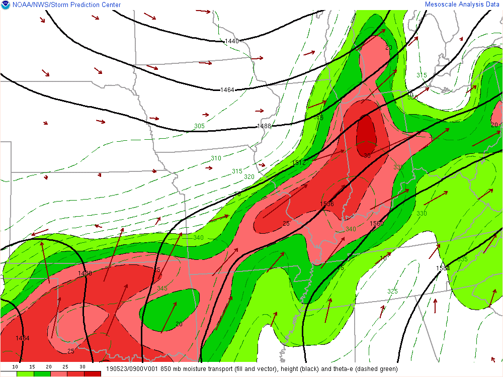 |
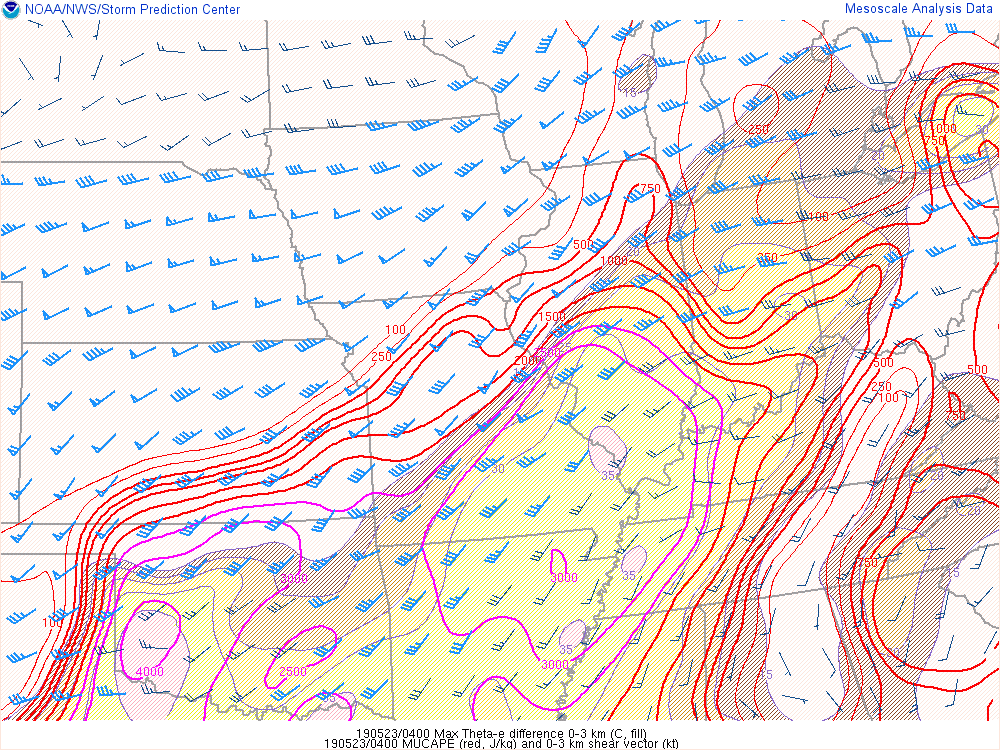
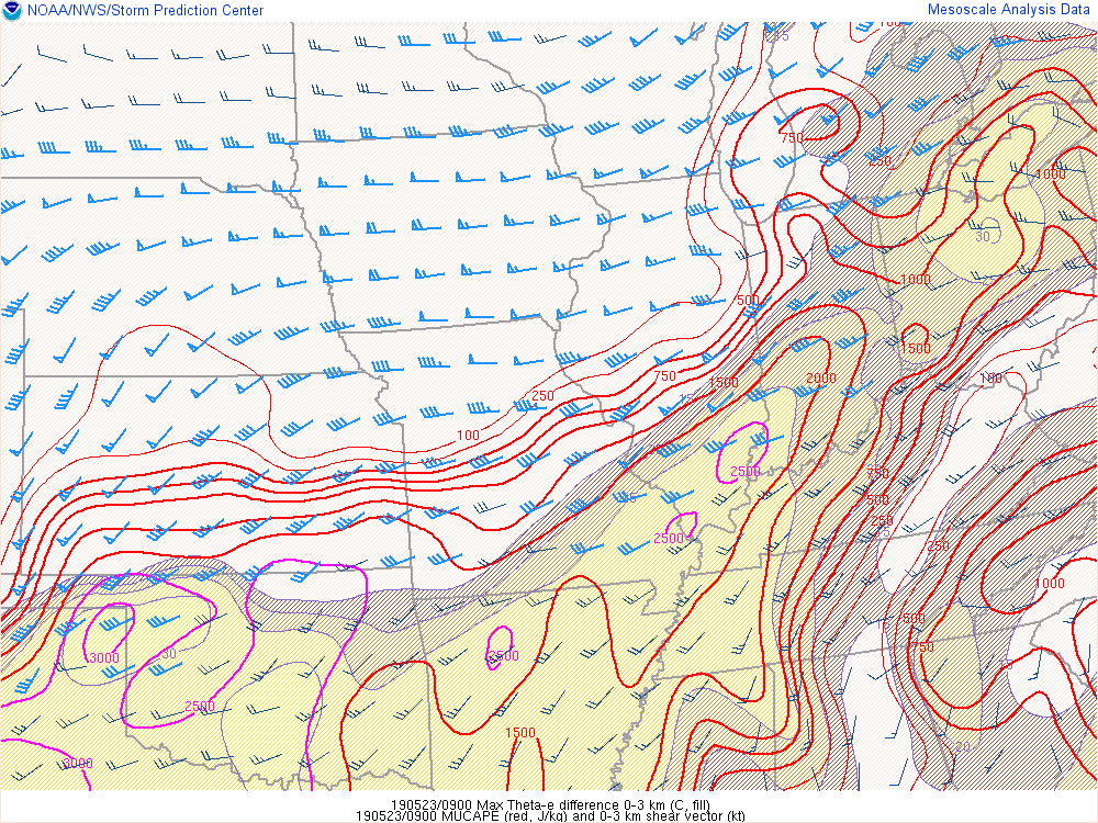
| Figure 4: MUCAPE and 0-3km shear valid 12am 5/23/19 | Figure 5: MUCAPE and 0-3km shear valid 5am 5/23/19 | Figure 6: 850 mb moisture transport valid 5am 5/23/19 |
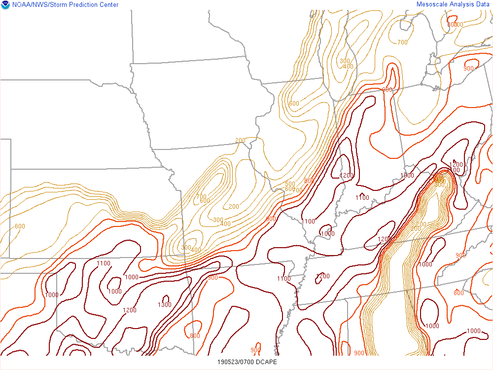
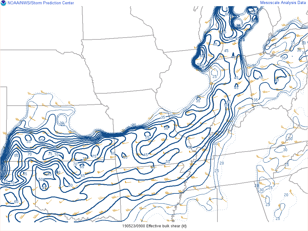
CAPE (Convective Available Potential Energy) is parameter to describe how buoyant the atmosphere, and a measure of the updraft potential. DCAPE (Downdraft Available Potential Energy) is a comparable parameter, but instead measures the acceleration potential of downdrafts. DCAPE values at or above 1000 J/kg can indicate favorable environments for strong downdraft potential as was the case here. Effective shear values of 40-55 knots combined with the instability allowed for maintenance of the severe storms across Illinois into the local area.
 |
 |
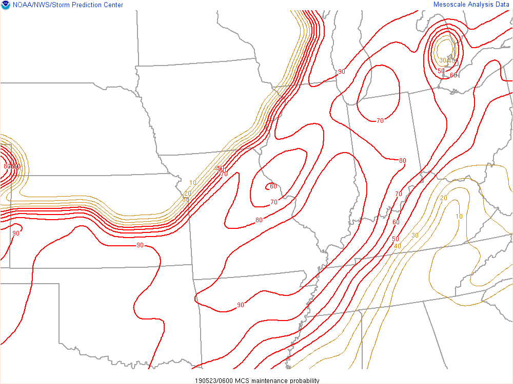 |
| Figure 7: DCAPE analysis valid 3am 5/23/19 | Figure 8: Effective shear analysis valid 5am 5/23/19 | Figure 9: MCS Maintenance Parameter valid 2am 5/23/19 |
 |
Media use of NWS Web News Stories is encouraged! Please acknowledge the NWS as the source of any news information accessed from this site. |
|

