Overview
A storm system affected the southern Great Lakes and Ohio Valley in two distinct pieces Tuesday evening through Wednesday. The initial phase of this system Tuesday night into early Wednesday morning produced between 1 and 3 inches of snow across many areas north of Route 24. The stronger portion of this system brought an additional 2 to 5 inches of snow on Wednesday. Temperatures near or slightly above freezing Tuesday evening resulted in slushy snow. The combination of colder air moving into the region Wednesday and increasing winds led patchy blowing and drifting snow Wednesday afternoon into Wednesday evening.
Snow/Ice
Below is a graphical depiction of some storm reports across the region. This plot of storm reports will soon be replaced with a more detailed snowfall map some time late Thursday as all of the event storm reports are received.

Storm Reports
PRELIMINARY LOCAL STORM REPORT...SUMMARY
NATIONAL WEATHER SERVICE NORTHERN INDIANA
1152 AM EST THU FEB 27 2020

LOCAL STORM REPORT SUMMARY FOR LATE FEB 25 TO EARLY FEB 27 2020 SNOWSTORM.

..TIME...   ...EVENT...      ...CITY LOCATION...     ...LAT.LON...
..DATE...   ....MAG....      ..COUNTY LOCATION..ST.. ...SOURCE....
            ..REMARKS..

0730 AM     SNOW             3 NE FORT WAYNE         41.10N 85.11W
02/27/2020  M4.6 INCH        ALLEN              IN   COCORAHS

            COCORAHS STATION IN-AL-51 FORT WAYNE 2.6 NE.

0700 AM     SNOW             2 NE ROLLING HILLS      41.05N 85.24W
02/27/2020  M5.3 INCH        ALLEN              IN   COCORAHS

            COCORAHS STATION IN-AL-6 FORT WAYNE 5.4 WSW.

0700 AM     SNOW             4 N NEW HAVEN           41.13N 85.03W
02/27/2020  M4.4 INCH        ALLEN              IN   COCORAHS

            COCORAHS STATION IN-AL-39 FORT WAYNE 7.0 NE.

0700 AM     SNOW             3 WSW WOODBURN          41.12N 84.91W
02/27/2020  M4.9 INCH        ALLEN              IN   COCORAHS

            COCORAHS STATION IN-AL-32 WOODBURN 2.8 WSW.

0700 AM     SNOW             4 NE FORT WAYNE         41.12N 85.09W
02/27/2020  M4.5 INCH        ALLEN              IN   COCORAHS

            COCORAHS STATION IN-AL-1 FORT WAYNE 4.1 NE.

0700 AM     SNOW             3 N WOODBURN            41.16N 84.85W
02/27/2020  M3.8 INCH        ALLEN              IN   CO-OP OBSERVER

            CO-OP OBSERVER STATION WDBI3 WOODBURN 3 N.

0642 AM     SNOW             3 NW FORT WAYNE         41.10N 85.18W
02/27/2020  M3.3 INCH        ALLEN              IN   COCORAHS

            COCORAHS STATION IN-AL-78 FORT WAYNE 2.6 NW.

0500 AM     SNOW             HUNTERTOWN              41.23N 85.17W
02/27/2020  M4.7 INCH        ALLEN              IN   PUBLIC

            VIA FACEBOOK.

0100 AM     SNOW             2 NE NINE MILE          40.99N 85.19W
02/27/2020  M3.6 INCH        ALLEN              IN   OFFICIAL NWS OBS

            UPDATES PREVIOUS SNOW REPORT FROM 2 NE NINE
            MILE. STORM TOTAL SNOWFALL.

0800 AM     SNOW             2 NNW MILL GROVE        40.44N 85.29W
02/27/2020  M3.9 INCH        BLACKFORD          IN   CO-OP OBSERVER

            CO-OP OBSERVER STATION HRRI3 HARTFORD CITY 4
            ESE.

0700 AM     SNOW             1 N HARTFORD CITY       40.46N 85.37W
02/27/2020  M3.8 INCH        BLACKFORD          IN   COCORAHS

            COCORAHS STATION IN-BL-11 (KA9VIS) HARTFORD
            CITY 0.7 N.

0800 AM     SNOW             1 E LOGANSPORT          40.75N 86.35W
02/27/2020  M2.5 INCH        CASS               IN   COCORAHS

            COCORAHS STATION IN-CS-16 LOGANSPORT 0.6 E.

0800 AM     SNOW             5 S DEACON              40.57N 86.33W
02/27/2020  M2.0 INCH        CASS               IN   CO-OP OBSERVER

            CO-OP OBSERVER STATION YNGI3 YOUNG AMERICA.

1200 AM     HEAVY SNOW       2 ESE HELMER            41.52N 85.13W
02/27/2020  M8.0 INCH        DE KALB            IN   TRAINED SPOTTER

            STORM TOTAL SNOWFALL.

0800 AM     SNOW             1 WNW JIMTOWN           41.64N 86.04W
02/27/2020  M4.1 INCH        ELKHART            IN   COCORAHS

            COCORAHS STATION IN-EL-36 ELKHART 4.8 SW.

0700 AM     SNOW             2 NNE WAKARUSA          41.57N 85.99W
02/27/2020  M3.4 INCH        ELKHART            IN   COCORAHS

            COCORAHS STATION IN-EL-8 WAKARUSA 2.4 NNE.

0700 AM     SNOW             1 SW GOSHEN             41.57N 85.85W
02/27/2020  M5.8 INCH        ELKHART            IN   COCORAHS

            COCORAHS STATION IN-EL-59 GOSHEN 1.2 SW.

0700 AM     SNOW             3 WSW GOSHEN            41.56N 85.88W
02/27/2020  M5.5 INCH        ELKHART            IN   COCORAHS

            COCORAHS STATION IN-EL-39 GOSHEN 3.0 WSW.

0700 AM     SNOW             1 WNW ROCHESTER         41.07N 86.21W
02/27/2020  M2.0 INCH        FULTON             IN   CO-OP OBSERVER

            CO-OP OBSERVER STATION RCRI3 ROCHESTER.

0400 PM     SNOW             AKRON                   41.04N 86.02W
02/26/2020  M4.0 INCH        FULTON             IN   TRAINED SPOTTER

            VIA PHONE.

0713 AM     SNOW             2 NNE MARION            40.58N 85.66W
02/27/2020  M3.3 INCH        GRANT              IN   CO-OP OBSERVER

            CO-OP OBSERVER STATION MZZI3 2.2 N MARION.

0700 AM     SNOW             2 NE UPLAND             40.48N 85.49W
02/27/2020  M2.5 INCH        GRANT              IN   COCORAHS

            COCORAHS STATION IN-GR-33 (KB9ZLT) UPLAND
            1.5 NE.

0700 AM     SNOW             1 ENE UPLAND            40.47N 85.50W
02/27/2020  M3.0 INCH        GRANT              IN   COCORAHS

            COCORAHS STATION IN-GR-29 (KD9CQQ)UPLAND 0.7
            ENE.

0515 AM     SNOW             2 NW MARION             40.57N 85.69W
02/27/2020  M3.2 INCH        GRANT              IN   COCORAHS

            COCORAHS STATION IN-GR-2 MARION 1.8 NW.

0825 PM     SNOW             MARION                  40.55N 85.67W
02/26/2020  M4.5 INCH        GRANT              IN   TRAINED SPOTTER

            VIA TWITTER.

0540 PM     SNOW             1 W HOME CORNER         40.52N 85.67W
02/26/2020  E4.9 INCH        GRANT              IN   TRAINED SPOTTER

            VIA TWITTER. MEASURED ON SNOWBOARD.

0700 AM     SNOW             HUNTINGTON              40.88N 85.51W
02/27/2020  M5.7 INCH        HUNTINGTON         IN   COCORAHS

            COCORAHS STATION IN-HT-1 HUNTINGTON 0.3 W.

0700 AM     SNOW             2 ENE WINONA LAKE       41.23N 85.78W
02/27/2020  M5.1 INCH        KOSCIUSKO          IN   COCORAHS

            COCORAHS STATION IN-KS-59 WARSAW 3.7 E.

0700 AM     SNOW             1 N MILFORD             41.42N 85.85W
02/27/2020  M5.5 INCH        KOSCIUSKO          IN   COCORAHS

            COCORAHS STATION IN-KS-42 MILFORD 0.9 N.

0700 AM     SNOW             LEESBURG                41.33N 85.85W
02/27/2020  M6.5 INCH        KOSCIUSKO          IN   COCORAHS

            COCORAHS STATION IN-KS-11 LEESBURG 0.1 WNW.

1200 AM     SNOW             3 S LAKE WAWASEE        41.36N 85.70W
02/27/2020  M7.3 INCH        KOSCIUSKO          IN   OFFICIAL NWS OBS

            STORM TOTAL SNOWFALL.

1100 PM     SNOW             JAMES LAKE              41.31N 85.72W
02/26/2020  M7.0 INCH        KOSCIUSKO          IN   NWS EMPLOYEE

            STORM TOTAL SNOWFALL.

0900 AM     SNOW             2 W HANNA               41.41N 86.81W
02/27/2020  M4.0 INCH        LA PORTE           IN   COCORAHS

            COCORAHS STATION IN-LP-2 WANATAH 4.4 ESE.

1100 AM     SNOW             LAGRANGE                41.65N 85.42W
02/27/2020  M7.0 INCH        LAGRANGE           IN   BROADCAST MEDIA

            VIA CHAT.

0500 AM     SNOW             2 N TWIN LAKES          41.33N 86.36W
02/27/2020  M4.9 INCH        MARSHALL           IN   COCORAHS

            COCORAHS STATION IN-ML-6 PLYMOUTH 2.5 WSW.

0700 AM     SNOW             1 NE DENVER             40.88N 86.06W
02/27/2020  M3.5 INCH        MIAMI              IN   COCORAHS

            COCORAHS STATION IN-MM-4 DENVER 1.3 NE.

0637 PM     SNOW             CONVERSE                40.58N 85.87W
02/26/2020  M4.0 INCH        MIAMI              IN   TRAINED SPOTTER

            VIA TWITTER.

0700 AM     SNOW             3 ENE ROME CITY         41.50N 85.31W
02/27/2020  M5.5 INCH        NOBLE              IN   COCORAHS

            COCORAHS STATION IN-NB-24 KENDALLVILLE 4.5
            NW.

0330 PM     SNOW             AVILLA                  41.37N 85.24W
02/26/2020  E5.0 INCH        NOBLE              IN   PUBLIC

            VIA FACEBOOK.

0730 AM     SNOW             NEW CARLISLE            41.71N 86.50W
02/27/2020  M3.5 INCH        ST. JOSEPH         IN   CO-OP OBSERVER

            CO-OP OBSERVER STATION NCLI3 NEW CARLISLE.

0710 AM     SNOW             2 NW OSCEOLA            41.68N 86.10W
02/27/2020  M5.6 INCH        ST. JOSEPH         IN   COCORAHS

            COCORAHS STATION IN-SJ-26 MISHAWAKA 3.9 ENE.

0700 AM     SNOW             2 ENE GULIVOIRE PARK    41.62N 86.22W
02/27/2020  M4.8 INCH        ST. JOSEPH         IN   COCORAHS

            COCORAHS STATION IN-SJ-58 SOUTH BEND 4.5 SE.

0700 AM     SNOW             2 ENE GULIVOIRE PARK    41.62N 86.22W
02/27/2020  M4.6 INCH        ST. JOSEPH         IN   COCORAHS

            COCORAHS STATION IN-SJ-28 SOUTH BEND 4.6 SE.

0700 AM     SNOW             3 N TEEGARDEN           41.50N 86.39W
02/27/2020  M4.3 INCH        ST. JOSEPH         IN   COCORAHS

            COCORAHS STATION IN-SJ-17 WALKERTON 5.7 ENE.

1200 AM     SNOW             1 S ROSELAND            41.70N 86.25W
02/27/2020  M4.5 INCH        ST. JOSEPH         IN   OFFICIAL NWS OBS

            STORM TOTAL SNOWFALL.

0755 AM     SNOW             1 WSW GOLDEN LAKE       41.60N 85.09W
02/27/2020  M6.5 INCH        STEUBEN            IN   COCORAHS

            COCORAHS STATION IN-SN-3 HUDSON 4.6 N.

0700 AM     SNOW             2 WNW ANGOLA            41.65N 85.03W
02/27/2020  M9.2 INCH        STEUBEN            IN   COCORAHS

            COCORAHS STATION IN-SN-33 ANGOLA 1.7 WNW.

0700 AM     SNOW             2 WSW GOLDEN LAKE       41.59N 85.10W
02/27/2020  M8.9 INCH        STEUBEN            IN   COCORAHS

            COCORAHS STATION IN-SN-2 HUDSON 4.1 NNW.

0545 AM     SNOW             3 ENE CROOKED LAKE      41.70N 84.99W
02/27/2020  M7.1 INCH        STEUBEN            IN   COCORAHS

            COCORAHS STATION IN-SN-9 ANGOLA 4.1 N.

0457 PM     SNOW             ANGOLA                  41.65N 85.00W
02/26/2020  E7.0 INCH        STEUBEN            IN   PUBLIC

            VIA FACEBOOK.

0400 PM     SNOW             1 ENE CROOKED LAKE      41.68N 85.02W
02/26/2020  M6.5 INCH        STEUBEN            IN   PUBLIC

            VIA FACEBOOK.

0600 AM     SNOW             WABASH                  40.80N 85.83W
02/27/2020  M3.0 INCH        WABASH             IN   COCORAHS

            COCORAHS STATION IN-WB-18 WABASH 0.3 NNW.

0600 AM     SNOW             1 NW LA FONTAINE        40.68N 85.74W
02/27/2020  M3.0 INCH        WABASH             IN   COCORAHS

            COCORAHS STATION IN-WB-10 LA FONTAINE 1.1
            NW.

0700 AM     SNOW             1 SE BLUFFTON           40.73N 85.16W
02/27/2020  M2.5 INCH        WELLS              IN   COCORAHS

            COCORAHS STATION IN-WL-11 BLUFFTON 0.9 SE.

0830 PM     SNOW             1 N BLUFFTON            40.76N 85.17W
02/26/2020  M2.3 INCH        WELLS              IN   TRAINED SPOTTER

            24 HOUR TOTAL. VIA PHONE.

0600 AM     SNOW             1 NNE MONTICELLO        40.76N 86.76W
02/27/2020  M3.1 INCH        WHITE              IN   COCORAHS

            COCORAHS STATION IN-WH-18 MONTICELLO 1.0
            NNE.

0500 AM     SNOW             5 W CHALMERS            40.67N 86.95W
02/27/2020  M1.7 INCH        WHITE              IN   CO-OP OBSERVER

            CO-OP OBSERVER STATION CHRI3 5.6 N BADGER
            GROVE.

0900 AM     SNOW             1 WSW COLUMBIA CITY     41.16N 85.49W
02/27/2020  M3.4 INCH        WHITLEY            IN   COCORAHS

            COCORAHS STATION IN-WY-24 COLUMBIA CITY 0.5
            WSW.

0700 AM     SNOW             1 SSW BIG LAKE          41.26N 85.51W
02/27/2020  M6.2 INCH        WHITLEY            IN   COCORAHS

            COCORAHS STATION IN-WY-1 COLUMBIA CITY 6.9
            N.

0400 PM     SNOW             1 SSE PEABODY           41.08N 85.49W
02/26/2020  E4.5 INCH        WHITLEY            IN   PUBLIC

            VIA FACEBOOK.

0700 AM     SNOW             1 ESE BUCHANAN          41.82N 86.34W
02/27/2020  M4.6 INCH        BERRIEN            MI   COCORAHS

            COCORAHS STATION MI-BN-3 BUCHANAN 1.4 ESE.

0700 AM     SNOW             1 WNW BUCHANAN          41.84N 86.39W
02/27/2020  M4.5 INCH        BERRIEN            MI   COCORAHS

            COCORAHS STATION MI-BN-5 BUCHANAN 1.3 WNW.

0610 AM     SNOW             2 SSE STEVENSVILLE      41.99N 86.51W
02/27/2020  M4.4 INCH        BERRIEN            MI   COCORAHS

            COCORAHS STATION MI-BN-2 STEVENSVILLE 1.7
            SSE.

0644 AM     SNOW             3 SE COLON              41.92N 85.28W
02/27/2020  M6.6 INCH        BRANCH             MI   COCORAHS

            COCORAHS STATION MI-BH-6 COLON 3.5 SE.

0404 PM     SNOW             1 ESE COLDWATER         41.94N 84.99W
02/26/2020  E7.0 INCH        BRANCH             MI   PUBLIC

            VIA FACEBOOK.

0700 PM     SNOW             1 NW DEWEY LAKE         42.07N 86.21W
02/26/2020  M6.0 INCH        CASS               MI   PUBLIC

            VIA FACEBOOK.

0800 AM     SNOW             2 W CAMDEN              41.75N 84.79W
02/27/2020  M5.7 INCH        HILLSDALE          MI   COCORAHS

            COCORAHS STATION MI-HL-9 MONTGOMERY 1.9 SSE.

0635 AM     SNOW             LITCHFIELD              42.05N 84.75W
02/27/2020  M7.9 INCH        HILLSDALE          MI   COCORAHS

            COCORAHS STATION MI-HL-1 LITCHFIELD 0.3 ENE.

0600 AM     SNOW             2 NW YODER              40.70N 84.10W
02/27/2020  M3.0 INCH        ALLEN              OH   COCORAHS

            COCORAHS STATION OH-AL-10 LIMA 3.0 SSE.

0600 AM     SNOW             2 ESE DELPHOS           40.83N 84.30W
02/27/2020  M4.5 INCH        ALLEN              OH   COCORAHS

            COCORAHS STATION OH-AL-8 DELPHOS 2.3 ESE.

0733 AM     SNOW             2 SSE BRAILEY           41.53N 83.91W
02/27/2020  M6.0 INCH        FULTON             OH   COCORAHS

            COCORAHS STATION OH-FL-13 SWANTON 4.0 S.

0935 PM     SNOW             3 ESE FAYETTE           41.66N 84.27W
02/26/2020  M7.0 INCH        FULTON             OH   TRAINED SPOTTER

            VIA TWITTER.

0800 AM     SNOW             1 WSW NAPOLEON          41.39N 84.14W
02/27/2020  M3.6 INCH        HENRY              OH   COCORAHS

            COCORAHS STATION OH-HY-7 NAPOLEON 0.6 WSW.

0700 AM     SNOW             3 SSE MCCLURE           41.33N 83.91W
02/27/2020  M3.5 INCH        HENRY              OH   COCORAHS

            COCORAHS STATION OH-HY-5 MCCLURE 3.4 SSE.

1030 AM     SNOW             OTTAWA                  41.02N 84.04W
02/27/2020  M4.6 INCH        PUTNAM             OH   TRAINED SPOTTER


0930 AM     SNOW             1 WNW VAN WERT          40.87N 84.60W
02/27/2020  M3.0 INCH        VAN WERT           OH   EMERGENCY MNGR

            STORM TOTAL SNOW.

0600 AM     SNOW             1 WNW MONTPELIER        41.59N 84.62W
02/27/2020  M4.0 INCH        WILLIAMS           OH   CO-OP OBSERVER

            CO-OP OBSERVER STATION MOPO1 MONTPELIER.


$$
Environment
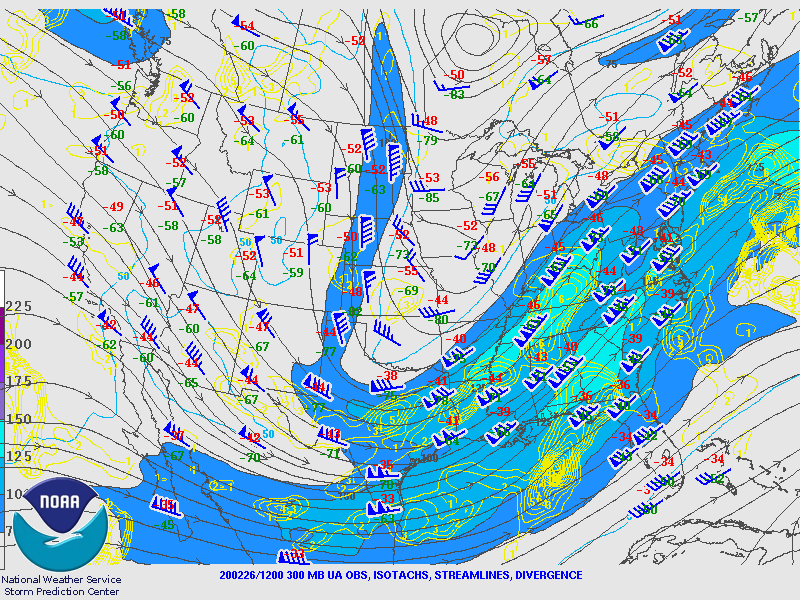
A mid and upper level system was responsible for bringing the heaviest snow to the region during the day Thursday.
 |
 |
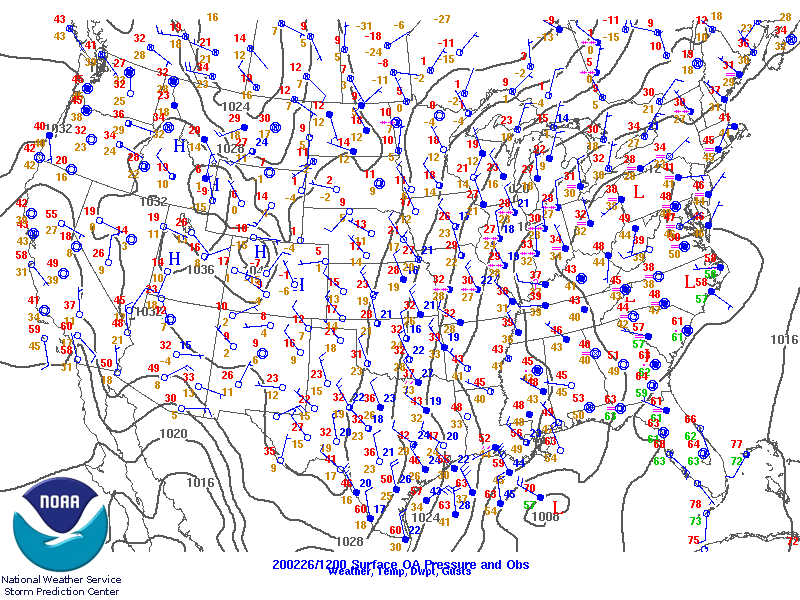 |
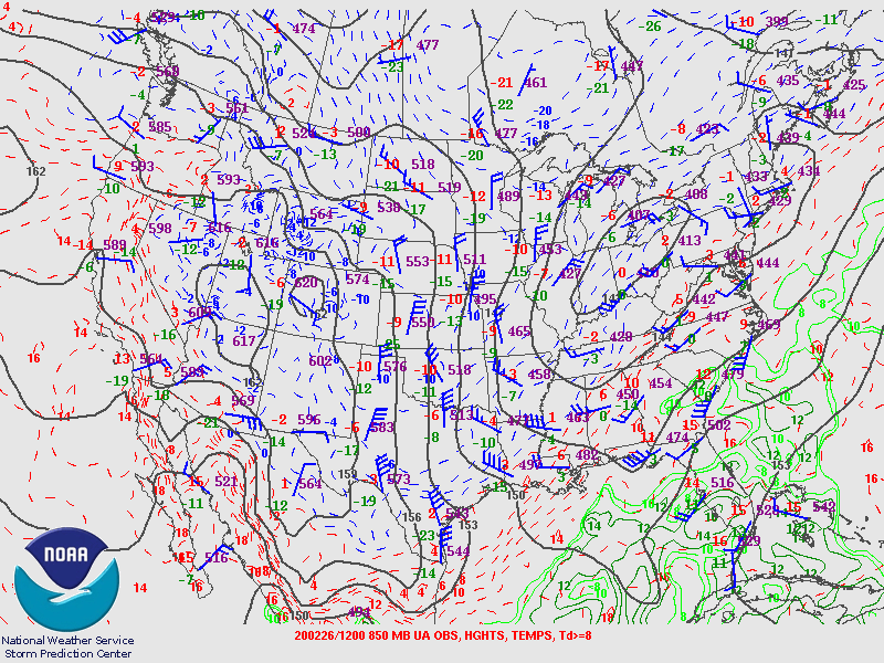
| Figure 1: 300 mb analysis 2/26/20 7am. Note the strong upper level jet streak lifting across the Ohio Valley. | Figure 2: 850 mb analysis 2/26/20 7am. This system was accompanied by a strong low level front which helped focus the period of best snowfall rates Wednesday. | Figure 3: Surface analysis 2/26/20 7am. Note the strengthening surface pressure gradient across the region. This provided gusty north winds and areas of blowing and drifting snow. |
 |
 |
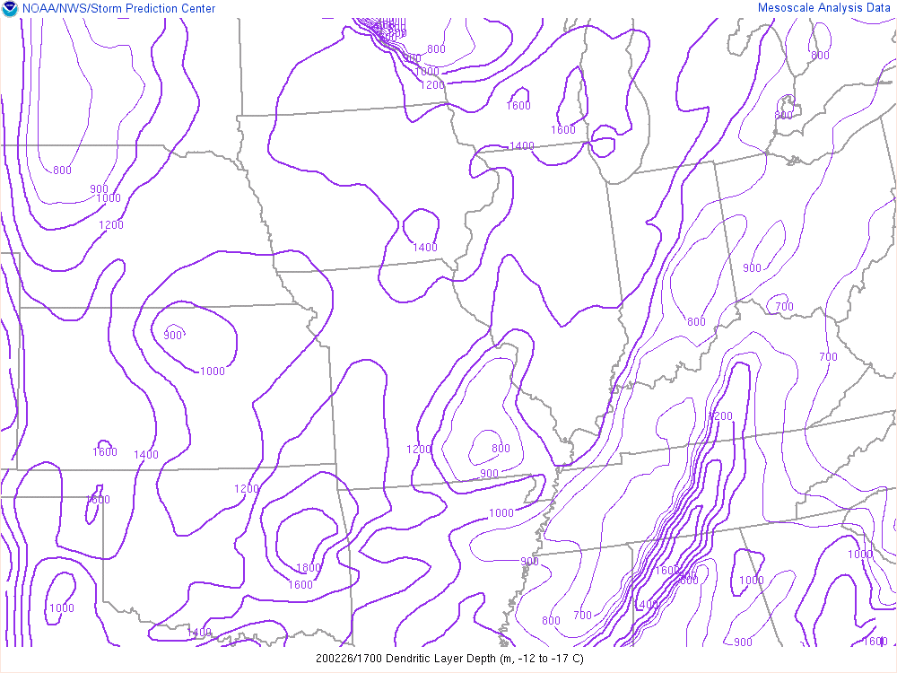 |
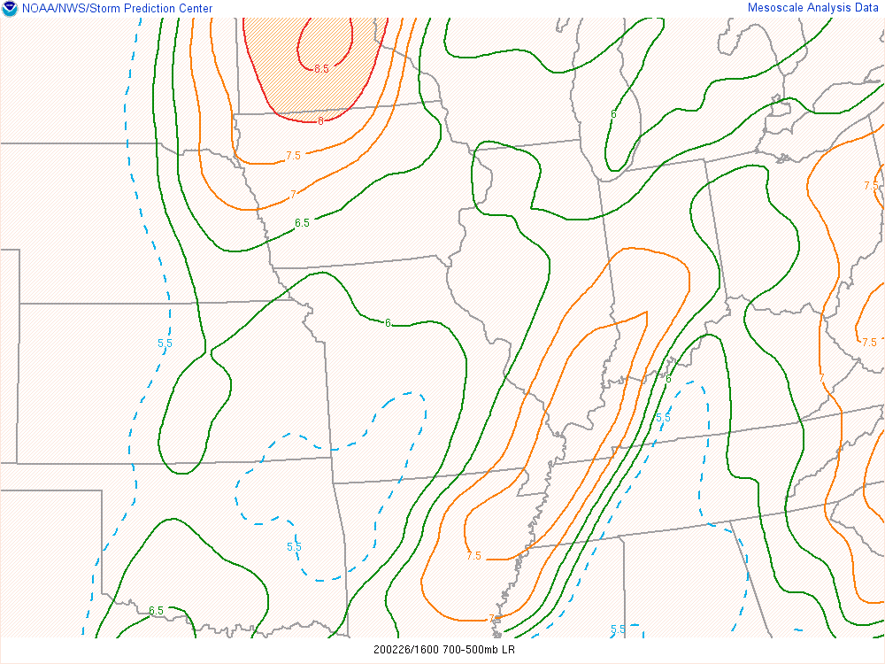
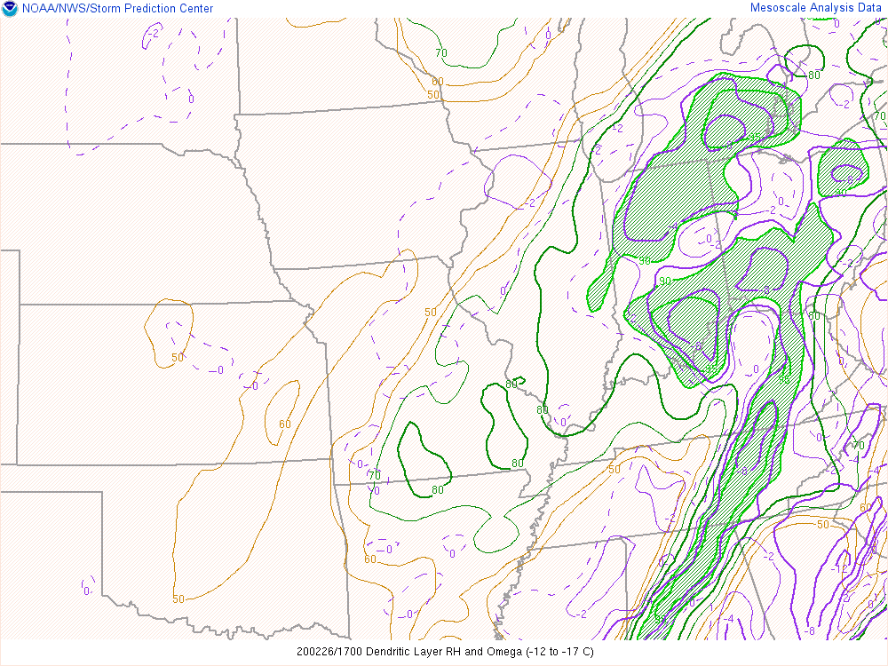
| Figure 4: 700-500 mb lapse rates 2/26/20 11am. Some instability aloft allowed some banded snow to form. In this image note the elevated instability axis nosing into northern Indiana midday Wednesday | Figure 5: RH Dendritic Growth Layer 2/26/20 12pm. A good deal of moisture in dendritic growth zone allowed for increasing snow to liquid ratios during the day Wednesday. | Figure 6: Dendritic Layer Depth 2/26/20 12pm. The dendritic growth zone also had some notable depth in excess of 1200 meters which allowed for more efficient snow production Wednesday afternoon. |
 |
Media use of NWS Web News Stories is encouraged! Please acknowledge the NWS as the source of any news information accessed from this site. |
|

