Overview
|
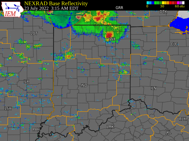
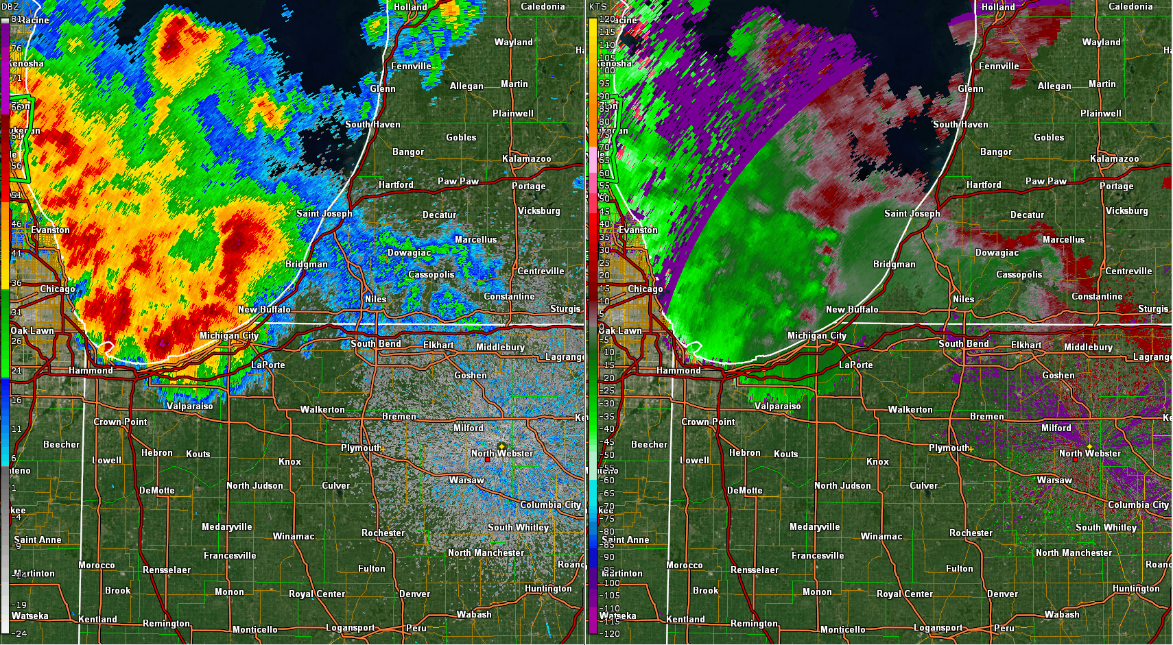
A cluster of strong storms over southern lake Michigan, around 6 AM EDT, organized further as they tracked into northwest Indiana/southwest Michigan which prompted initial severe warnings based on deep cores (50dbz > 40kft) and emerging wind signatures. The most intense line segment peeled east-southeastward and hammered Elkhart, Kosciusko, and Whitley counties with widespread wind damage. An initial 70mph wind gust was recorded followed by a second 73 mph gust around 3 min later with a microburst core over Kosciusko County. The eastward leading convective line proved more vigorous as it aligned with the low-level shear vector and produced additional wind damage into northwest Ohio (Van Wert county). Additional intensification occurred to the west within the larger line segment with gusts 58-62 mph noted in AWOS METARS from Monticello east to Grissom Airports. |
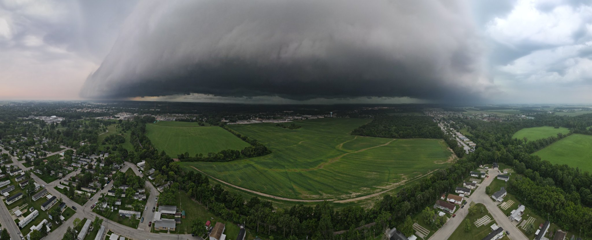 A shelf cloud approaching Bluffton, IN. Via @jtinneywx |
Wind & Hail:
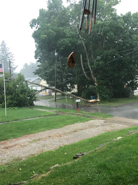
There were numerous reports of trees and large branches down from northwest Indiana, southeast to western Allen County, Indiana. Hail was reported near Plymouth, Cromwell, Fort Wayne, and Angola. the largest report was 1.75 inches (golf ball size) near New Haven, IN.
The greatest recorded wind gust was 73 mph, near James Lake, IN. Additional wind gusts in northern Indiana were in the range of 50 to 70 mph. These wind gusts resulted in power outages and downed numerous trees.
 |
 |
 |
 |
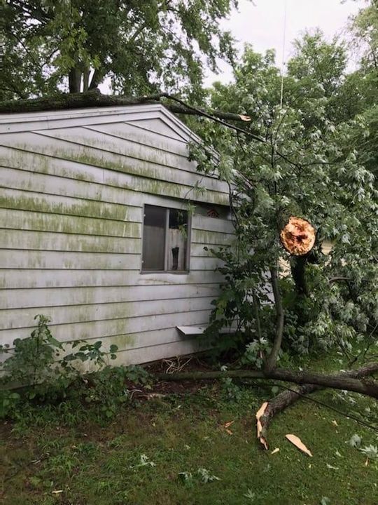
| A large, healthy tree was snapped in Elkhart, IN. Picture from Keith Thews. | A healthy tree was split in Fairmount, IN. Picture from an anonymous source. | A tree was uprooted at Lake Chapman, resulting in significant damage to a home. Picture from Heather Mitchell Coble. | A tree branch pierced through the windshield of a minivan in LaPorte, IN. Picture from Andrew Bordner. |
Radar
 |
 |
 |
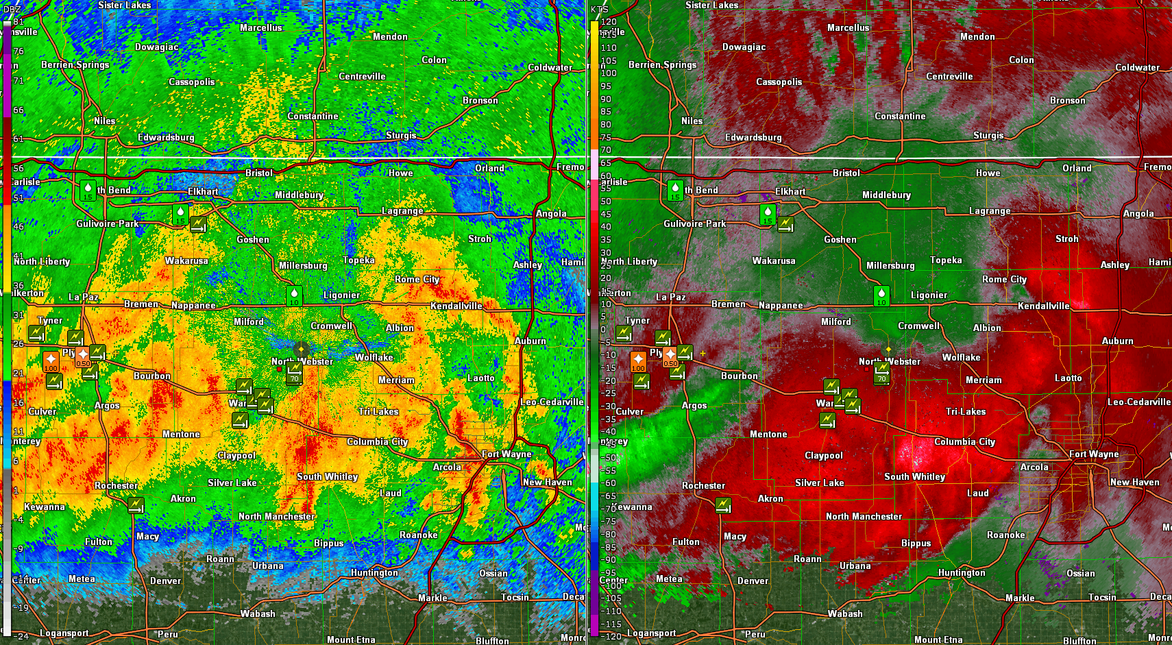 |
| Radar loop with watches and warnings from 3:15 AM-1:00 PM EDT. Iowa State University. | Radar loop from 3:15 AM-1:00 PM EDT. Iowa State University. | A line of strong thunderstorms arrived onshore during the 5 AM EDT hour. Soon after, thunderstorm wind damage was reported. | This radar loop centered over Kosciusko County shows the local storm reports and the velocity data during the 7AM EDT hour. |
Storm Reports
PRELIMINARY LOCAL STORM REPORT...SUMMARY
NATIONAL WEATHER SERVICE NORTHERN INDIANA
222 PM EDT SAT JUL 23 2022

..TIME...   ...EVENT...      ...CITY LOCATION...     ...LAT.LON...
..DATE...   ....MAG....      ..COUNTY LOCATION..ST.. ...SOURCE....
            ..REMARKS..

0851 AM     TSTM WND GST     1 WSW CECIL             41.22N 84.62W
07/23/2022  M48 MPH          PAULDING           OH   PUBLIC

            GUSTY WINDS BROKE BRANCH OFF TREE.

0820 AM     TSTM WND DMG     2 NNW DISKO             41.03N 85.97W
07/23/2022                   FULTON             IN   911 CALL CENTER

            TREE DOWN. TIME ESTIMATED FROM RADAR.

0728 AM     TSTM WND DMG     2 N DONALDSON           41.39N 86.44W
07/23/2022                   MARSHALL           IN   DEPT OF HIGHWAYS

            TREE DOWN ON 6TH ROAD AND UNION ROAD. TIME
            ESTIMATED FROM RADAR.

0405 AM     HAIL             2 N FAIRFIELD CENTER    41.51N 85.13W
07/23/2022  E1.00 INCH       DE KALB            IN   CO-OP OBSERVER

            QUARTER SIZE HAIL LASTED ABOUT 1 MINUTE AT
            STORY LAKE.

0925 AM     TSTM WND DMG     FAIRMOUNT               40.41N 85.64W
07/23/2022                   GRANT              IN   PUBLIC

            TREE DOWN ON POWER LINE. TIME ESTIMATED FROM
            RADAR.

0855 AM     TSTM WND GST     GOLDEN HILL             40.71N 86.77W
07/23/2022  M58 MPH          WHITE              IN   AWOS

            MONTICELLO WHITE COUNTY AIRPORT.

0445 AM     HAIL             1 E GOLDEN LAKE         41.61N 85.05W
07/23/2022  U1.00 INCH       STEUBEN            IN   PUBLIC

            REPORT FROM MPING: QUARTER (1.00 IN.).

0856 AM     TSTM WND GST     GRISSOM AFB             40.66N 86.14W
07/23/2022  M62 MPH          MIAMI              IN   AWOS


0647 AM     TSTM WND DMG     3 WNW GULIVOIRE PARK    41.63N 86.31W
07/23/2022                   ST. JOSEPH         IN   PUBLIC

            TREE ACROSS IRELAND ROAD AND MYRTLE ROAD.
            VIA TWITTER.

0655 AM     TSTM WND DMG     2 NNE GULIVOIRE PARK    41.64N 86.23W
07/23/2022                   ST. JOSEPH         IN   PUBLIC

            LARGE TREE BLOCKING RIDGEDALE ROAD. VIA
            TWITTER. TIME ESTIMATED FROM RADAR.

0830 AM     TSTM WND DMG     3 E HASTINGS            41.38N 85.88W
07/23/2022                   KOSCIUSKO          IN   PUBLIC


0745 AM     TSTM WND GST     1 SSE JAMES LAKE        41.31N 85.72W
07/23/2022  M73 MPH          KOSCIUSKO          IN   NWS EMPLOYEE

            MEASURED WIND GUST TO 73 MPH, HUGE TREE
            DOWN, NUMEROUS LARGE BRANCHES DOWN.

0728 AM     TSTM WND DMG     2 ESE JIMTOWN           41.62N 85.99W
07/23/2022                   ELKHART            IN   PUBLIC

            5 INCH DIAMETER LIMB APPROX. 20 FEET LONG
            DOWN. SEVERAL SMALLER BRANCHES DOWN AS WELL.

0825 AM     TSTM WND DMG     2 WNW KEWANNA           41.03N 86.45W
07/23/2022                   FULTON             IN   911 CALL CENTER

            TREES AND UTILITY LINES DOWN. TIME ESTIMATED
            FROM RADAR.

0827 AM     TSTM WND DMG     1 WNW KEWANNA           41.03N 86.43W
07/23/2022                   FULTON             IN   911 CALL CENTER

            TREE DOWN. TIME ESTIMATED FROM RADAR.

0830 AM     TSTM WND DMG     KEWANNA                 41.02N 86.40W
07/23/2022                   FULTON             IN   911 CALL CENTER

            TREE DOWN. TIME ESTIMATED FROM RADAR.

0715 AM     HAIL             1 S KOONTZ LAKE         41.41N 86.48W
07/23/2022  U1.00 INCH       STARKE             IN   PUBLIC

            REPORT FROM MPING: QUARTER (1.00 IN.).

0633 AM     TSTM WND DMG     LA PORTE                41.60N 86.72W
07/23/2022                   LA PORTE           IN   PUBLIC

            TREE BRANCH IMPALED WINDSHIELD OF MINIVAN.
            VIA TWITTER.

0825 AM     TSTM WND DMG     1 SE LAKE BRUCE         41.06N 86.45W
07/23/2022                   FULTON             IN   911 CALL CENTER

            TREE DOWN. TIME ESTIMATED FROM RADAR.

0825 AM     TSTM WND DMG     3 N LAKE BRUCE          41.11N 86.46W
07/23/2022                   FULTON             IN   911 CALL CENTER

            TREE DOWN. TIME ESTIMATED FROM RADAR.

0815 AM     TSTM WND DMG     2 SE LAKE MANITOU       41.03N 86.16W
07/23/2022                   FULTON             IN   911 CALL CENTER

            TREE DOWN. TIME ESTIMATED FROM RADAR.

0920 AM     TSTM WND DMG     3 NNW MARION            40.59N 85.68W
07/23/2022                   GRANT              IN   TRAINED SPOTTER

            HEARD OVER SCANNER REPORTS OF TREES DOWN AND
            DEBRIS IN ROADWAY.

0922 AM     TSTM WND DMG     1 SE MARION             40.54N 85.66W
07/23/2022                   GRANT              IN   TRAINED SPOTTER

            HEARD ON SCANNER REPORT OF TREE ON HOUSE AND
            POWER LINES.

0755 AM     TSTM WND DMG     MONOQUET                41.28N 85.86W
07/23/2022                   KOSCIUSKO          IN   NWS EMPLOYEE

            LARGE, 2 FOOT DIAMETER BRANCH DOWNED.

0715 AM     TSTM WND DMG     1 WSW NAPPANEE          41.44N 86.00W
07/23/2022                   ELKHART            IN   EMERGENCY MNGR

            WIDESPREAD WIND DAMAGE.

0835 AM     HAIL             3 NNW NEW HAVEN         41.11N 85.05W
07/23/2022  E1.75 INCH       ALLEN              IN   PUBLIC

            REPORT FROM MPING: GOLF BALL.

0935 AM     TSTM WND DMG     OHIO CITY               40.77N 84.62W
07/23/2022                   VAN WERT           OH   EMERGENCY MNGR

            NUMEROUS TREES AND POWER LINES DOWN. PARK
            SHELTER DESTROYED. TIME ESTIMATED FROM
            RADAR.

0705 AM     TSTM WND DMG     2 ENE OSCEOLA           41.67N 86.04W
07/23/2022                   ELKHART            IN   PUBLIC

            TREE DOWN ON HOUSE. VIA FACEBOOK. TIME
            ESTIMATED FROM RADAR.

0640 AM     TSTM WND DMG     3 S OSWEGO              41.28N 85.79W
07/23/2022                   KOSCIUSKO          IN   PUBLIC

            TREES DOWN ON MOBILE HOMES AROUND CHAPMAN
            LAKE. VIA FACEBOOK.

0728 AM     TSTM WND DMG     2 NNW PLYMOUTH          41.38N 86.33W
07/23/2022                   MARSHALL           IN   DEPT OF HIGHWAYS

            TREE DOWN ON 7TH ROAD AND OAK ROAD. TIME
            ESTIMATED VIA RADAR.

0733 AM     TSTM WND DMG     3 SSE PLYMOUTH          41.31N 86.29W
07/23/2022                   MARSHALL           IN   DEPT OF HIGHWAYS

            TREES DOWN ON 13TH ROAD WEST OF QUEEN ROAD.
            TIME ESTIMATED VIA RADAR.

0738 AM     TSTM WND DMG     2 E PLYMOUTH            41.35N 86.27W
07/23/2022                   MARSHALL           IN   PUBLIC

            TREE DOWN ON US 31. VIA FACEBOOK. TIME
            ESTIMATED FROM RADAR.

0100 PM     TSTM WND DMG     REYNOLDS                40.75N 86.88W
07/23/2022                   WHITE              IN   911 CALL CENTER

            TREES AND POWER LINES DOWN.

0214 PM     HEAVY RAIN       1 SW REYNOLDS           40.74N 86.88W
07/23/2022  M3.00 INCH       WHITE              IN   EMERGENCY MNGR


0745 AM     TSTM WND DMG     SECHRIST LAKE           41.30N 85.72W
07/23/2022                   KOSCIUSKO          IN   BROADCAST MEDIA

            TREES UPROOTED AND BROKEN. VIA TWITTER. TIME
            ESTIMATED FROM RADAR.

0651 AM     TSTM WND DMG     2 SE SOUTH BEND         41.66N 86.24W
07/23/2022                   ST. JOSEPH         IN   PUBLIC

            TREE DOWN IN ROAD ON E DAYTON STREET. VIA
            TWITTER. TIME ESTIMATED BY RADAR.

0729 AM     HAIL             3 NW TWIN LAKES         41.33N 86.40W
07/23/2022  U1.00 INCH       MARSHALL           IN   PUBLIC

            REPORT FROM MPING: QUARTER (1.00 IN.).

0733 AM     TSTM WND DMG     2 SW TWIN LAKES         41.29N 86.39W
07/23/2022                   MARSHALL           IN   DEPT OF HIGHWAYS

            TREES DOWN ON MICHIGAN STREET BETWEEN 11TH
            AND 12TH ROADS. TIME ESTIMATED BY RADAR.

0740 AM     TSTM WND DMG     1 ENE WARSAW            41.25N 85.83W
07/23/2022                   KOSCIUSKO          IN   NWS EMPLOYEE

            3 LARGE TREES DOWN.

0742 AM     TSTM WND DMG     2 NE WARSAW             41.26N 85.81W
07/23/2022                   KOSCIUSKO          IN   TRAINED SPOTTER

            LARGE TREE ON POWER LINE. TIME ESTIMATED
            FROM RADAR.

0810 AM     TSTM WND DMG     3 SSW WARSAW            41.21N 85.87W
07/23/2022                   KOSCIUSKO          IN   PUBLIC

            HEALTH 10 INCH DIAMETER TREE LIMB BROKE. VIA
            FACEBOOK.

0745 AM     TSTM WND DMG     2 NNE WINONA LAKE       41.24N 85.80W
07/23/2022                   KOSCIUSKO          IN   NWS EMPLOYEE

            2 FOOT DIAMETER TREE DOWN.
Rain Reports
PUBLIC INFORMATION STATEMENT
NATIONAL WEATHER SERVICE NORTHERN INDIANA
211 PM EDT SAT JUL 23 2022

...24 PRECIPITATION REPORTS ENDING 2PM 23 JULY 2022...

LOCATION                     AMOUNT    TIME/DATE       LAT/LON

...INDIANA...

...ALLEN COUNTY...
FORT WAYNE 2.6 NW            1.31 IN   1016 AM 07/23   41.10N/85.18W
3 SSE DUNFEE                 1.20 IN   1000 AM 07/23   41.05N/85.32W
FORT WAYNE 8.0 N             1.11 IN   1115 AM 07/23   41.19N/85.11W
FORT WAYNE INTERNATIONAL AP  1.02 IN   0154 PM 07/23   40.98N/85.18W

...CASS COUNTY...
1 N NEW WAVERLY              1.25 IN   1027 AM 07/23   40.78N/86.20W

...ELKHART COUNTY...
JAMESTOWN                    2.14 IN   0200 PM 07/23   41.64N/86.04W
ELKHART 4.8 SW               1.74 IN   0800 AM 07/23   41.64N/86.04W
GOSHEN 2.8 NNE               1.39 IN   1100 AM 07/23   41.61N/85.81W
SYRACUSE 3.3 NNE             1.08 IN   0800 AM 07/23   41.47N/85.72W

...FULTON COUNTY...
ATHENS                       1.12 IN   0155 PM 07/23   41.07N/86.13W

...KOSCIUSKO COUNTY...
WINONA LAKE 1.2 E            2.17 IN   1000 AM 07/23   41.22N/85.79W
NE TULARE                    1.56 IN   0155 PM 07/23   41.20N/85.71W
5.5 NNE WARSAW               1.39 IN   0155 PM 07/23   41.33N/85.77W
MILFORD                      1.20 IN   0155 PM 07/23   41.42N/85.85W
1 SW SEVASTOPOL              1.17 IN   0159 PM 07/23   41.11N/86.04W

...LA PORTE COUNTY...
LA PORTE 6.8 SW              2.20 IN   0800 AM 07/23   41.55N/86.82W
LA PORTE 2.3 ESE             2.17 IN   0930 AM 07/23   41.59N/86.68W
TRAIL CREEK 3.0 SE           2.15 IN   0800 AM 07/23   41.67N/86.81W
MICHIGAN CITY 3.9 SE         2.08 IN   1030 AM 07/23   41.67N/86.83W
LA PORTE                     1.81 IN   0135 PM 07/23   41.57N/86.73W
1 W MICHIGAN CITY            1.61 IN   0200 PM 07/23   41.71N/86.90W
LA PORTE 1.6 SW              1.59 IN   0714 AM 07/23   41.59N/86.73W
WANATAH 3.0 ENE              1.48 IN   0800 AM 07/23   41.44N/86.83W
WANATAH 4.4 ESE              1.48 IN   0900 AM 07/23   41.41N/86.81W
MILL CREEK 1.9 NNE           1.12 IN   0715 AM 07/23   41.61N/86.52W

...MARSHALL COUNTY...
PLYMOUTH 3.8 SSW             2.03 IN   0800 AM 07/23   41.30N/86.35W
BREMEN 3.9 WSW               1.79 IN   1235 PM 07/23   41.43N/86.23W
MENTONE                      1.36 IN   0157 PM 07/23   41.18N/86.08W

...PULASKI COUNTY...
1.3 SW ORA                   1.69 IN   0145 PM 07/23   41.16N/86.56W

...ST. JOSEPH COUNTY...
SOUTH BEND 2.2 NW            1.64 IN   0814 AM 07/23   41.69N/86.30W
SOUTH BEND INTERNATIONAL AP  1.53 IN   0154 PM 07/23   41.70N/86.32W
SOUTH BEND                   1.52 IN   0158 PM 07/23   41.64N/86.23W
MISHAWAKA                    1.31 IN   0200 PM 07/23   41.65N/86.13W
OSCEOLA                      1.31 IN   0155 PM 07/23   41.64N/86.06W
NEW CARLISLE                 1.27 IN   0200 PM 07/23   41.66N/86.51W

...STARKE COUNTY...
WALKERTON 4.4 SSW            2.08 IN   0900 AM 07/23   41.40N/86.51W
WINONA                       1.53 IN   0913 AM 07/23   41.24N/86.57W

...WHITE COUNTY...
2 WSW WOLCOTT                2.38 IN   0200 PM 07/23   40.74N/87.09W
MONTICELLO - WHITE COUNTY AR 1.80 IN   0155 PM 07/23   40.72N/86.77W
MONTICELLO                   1.51 IN   0200 PM 07/23   40.74N/86.77W

...WHITLEY COUNTY...
COLUMBIA CITY 0.5 WSW        1.07 IN   0904 AM 07/23   41.16N/85.49W

...OHIO...

...VAN WERT COUNTY...
VAN WERT                     1.22 IN   0200 PM 07/23   40.87N/84.59W
1 ENE VAN WERT               1.04 IN   0159 PM 07/23   40.87N/84.56W
&&
 |
Media use of NWS Web News Stories is encouraged! Please acknowledge the NWS as the source of any news information accessed from this site. |
|

