Overview
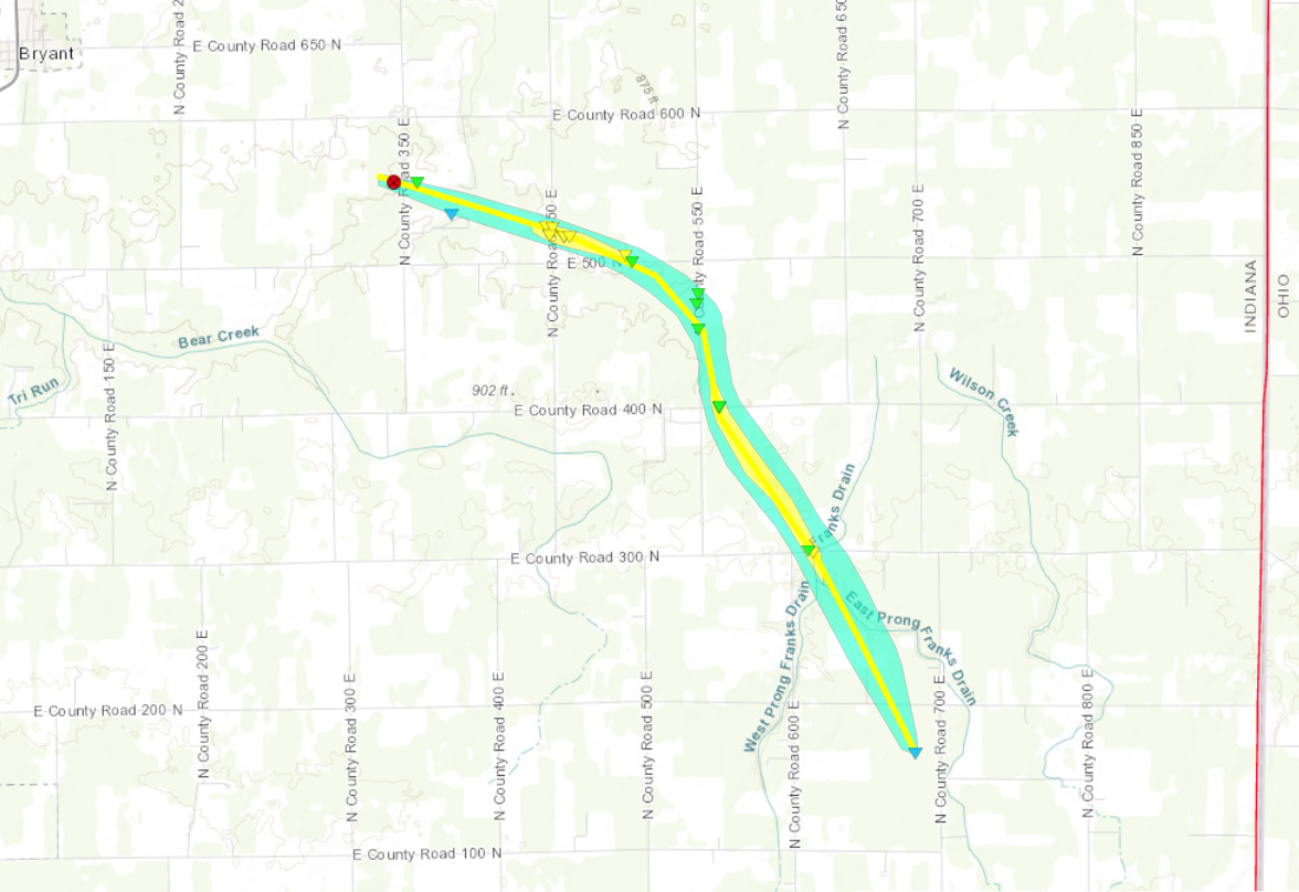
A few round of showers and thunderstorms affected the area Friday morning into Friday afternoon. The first round produced some locally heavy rain and some isolated wind damage across southern Lower Michigan and portions of northern Indiana. Storms redeveloped in the afternoon south of US Route 24. One of these storms developed into a supercell and produced a tornado across northeast Jay County. The National Weather Service will be conducting a storm survey across this area on Saturday. This page will be updated with additional information as it becomes available later today regarding the Jay County, IN tornado. Thank you to emergency management, media, spotters, and the public for valuable reports during this event.Tornadoes:
|
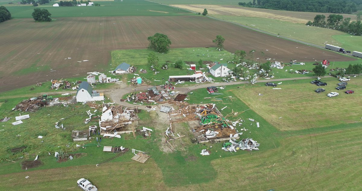
Tornado - E of Bryant, IN
|
||||||||||||||||
The Enhanced Fujita (EF) Scale classifies tornadoes into the following categories:
| EF0 Weak 65-85 mph |
EF1 Moderate 86-110 mph |
EF2 Significant 111-135 mph |
EF3 Severe 136-165 mph |
EF4 Extreme 166-200 mph |
EF5 Catastrophic 200+ mph |
 |
|||||
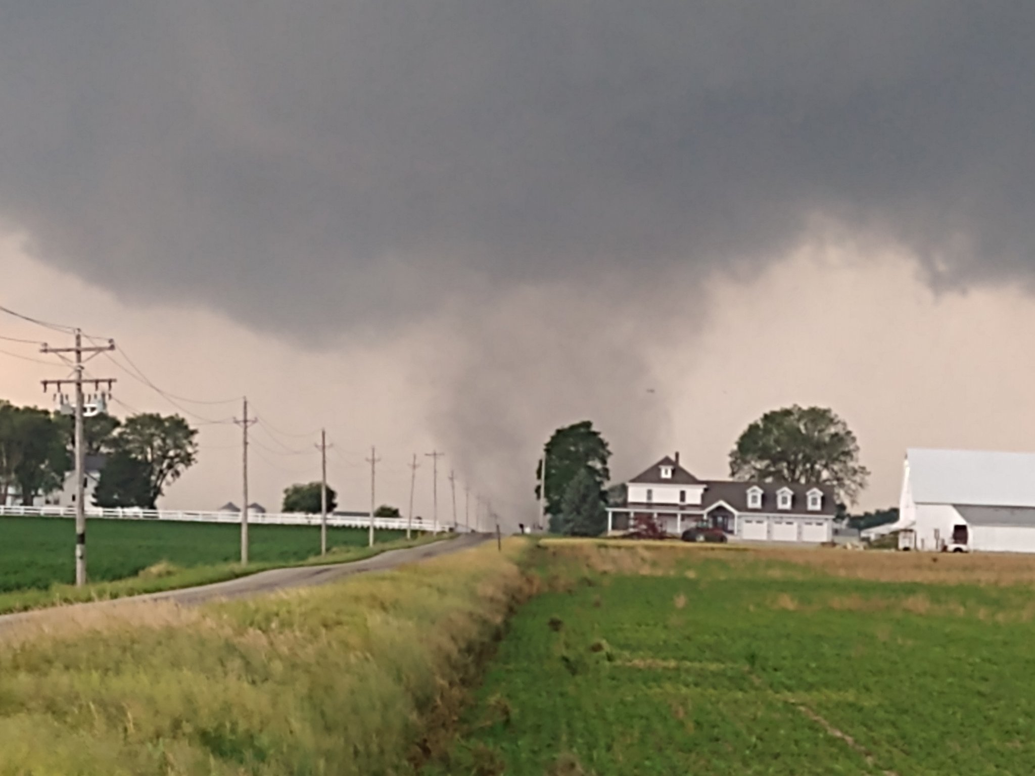
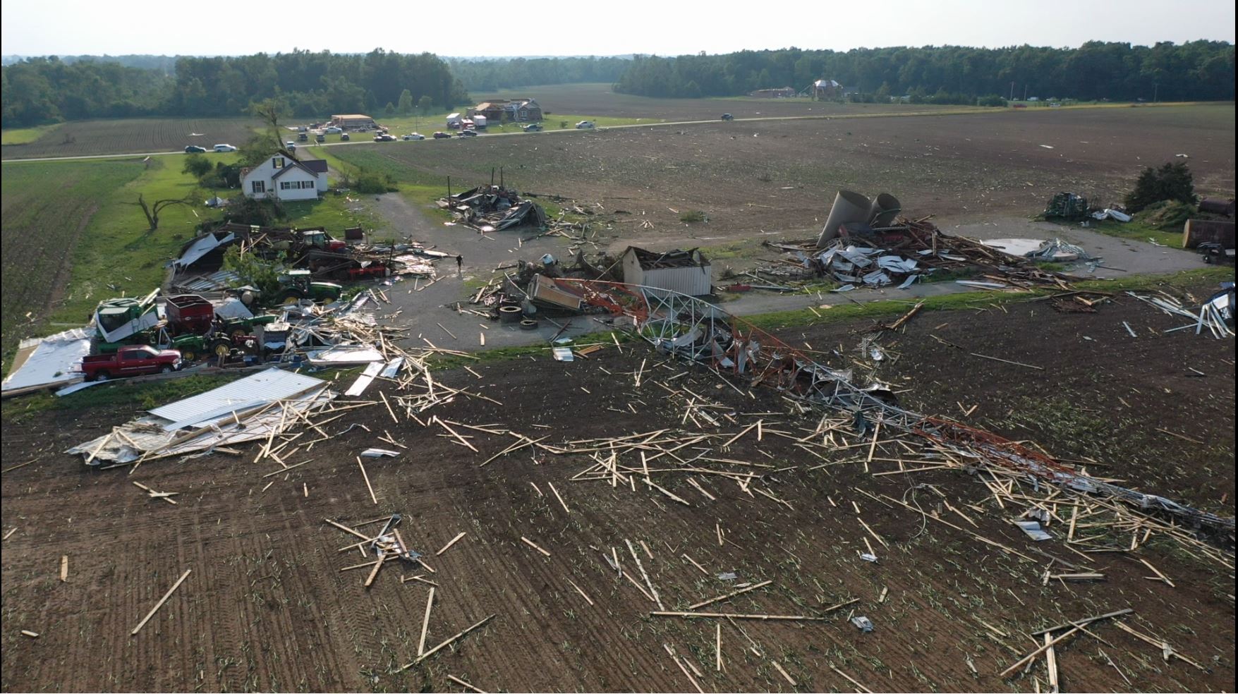
Photos & Video
 |
 |
 |
 |
| Tornado near Portland, IN (Ben Kessler & Austin Hespe) |
Damage southeast of Bryant, IN (WPTA) |
Damage southeast of Bryant, IN (WPTA) |
Tornado Damage in Jay County, IN (Sgt. Josh Stephenson @ppdjs725) |
| Tornado northeast of Westchester Indiana. Video courtesty of Chris Howell |
Radar
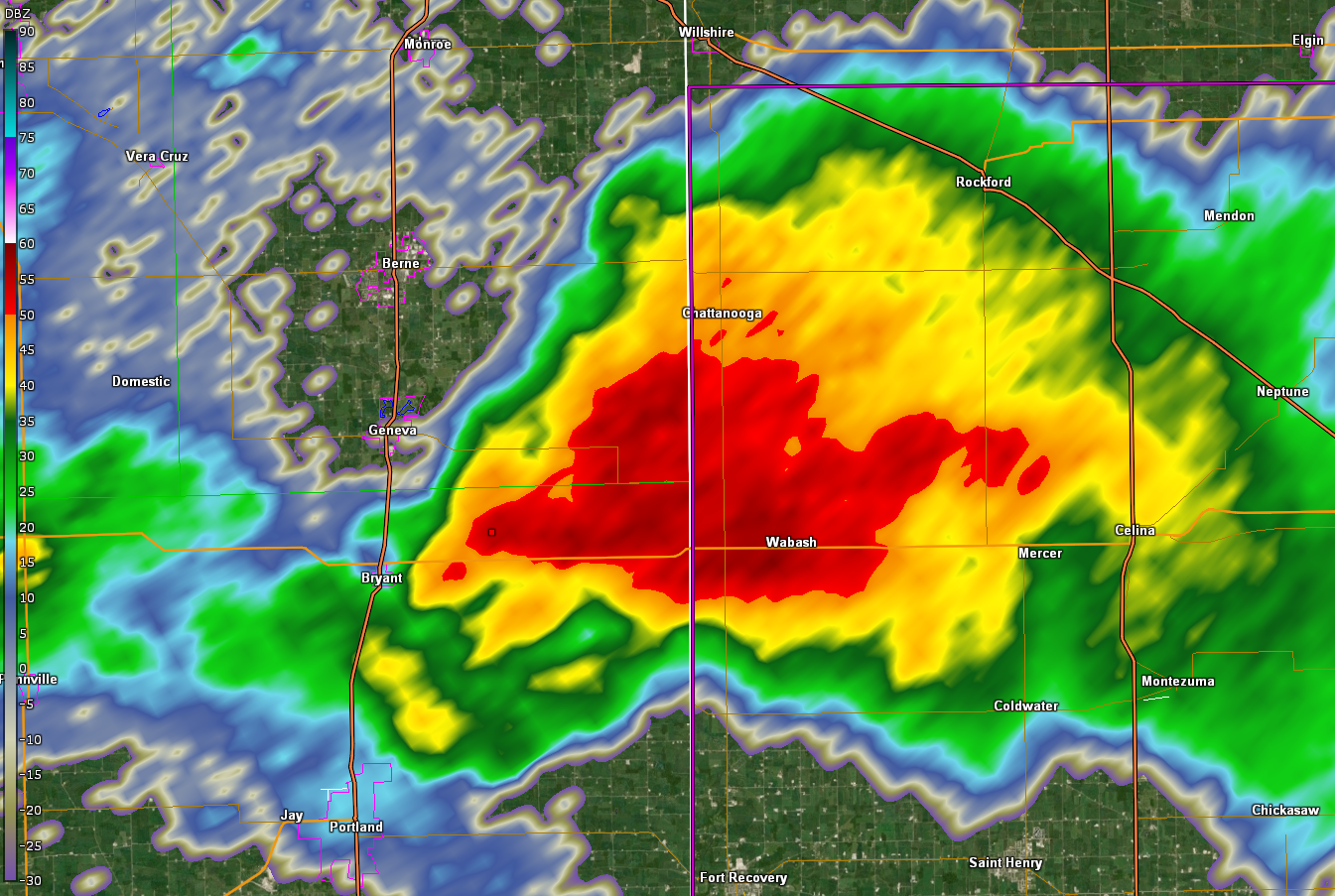
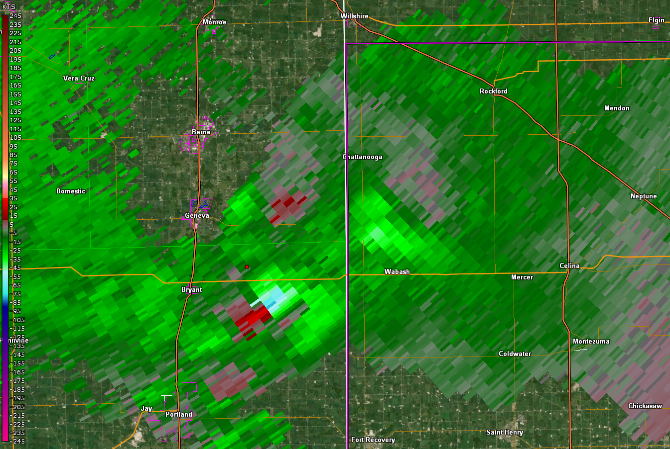
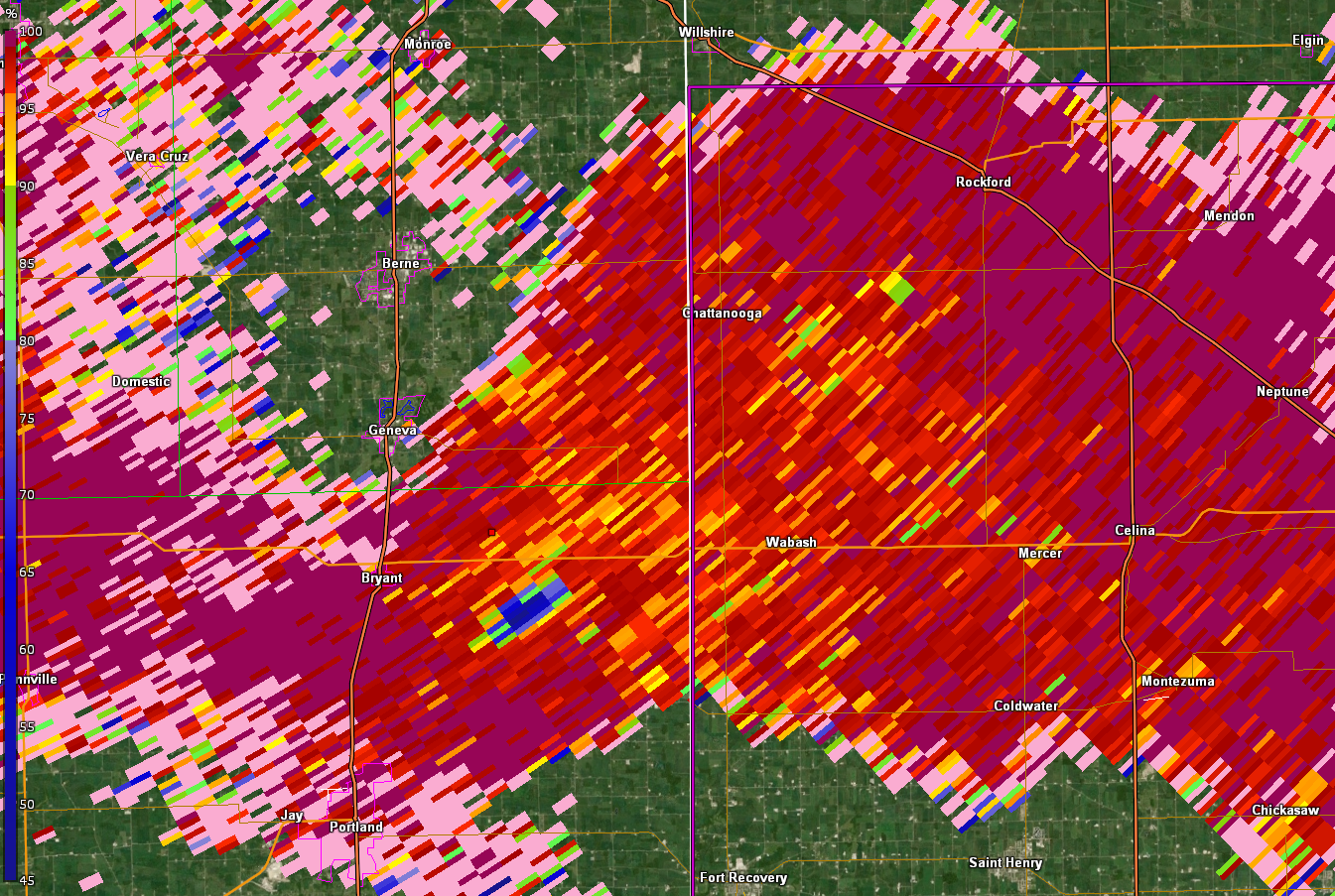
Below are select radar images from the Tornado near Portland, IN. Reflectivity shows the supercell structure, with a tight rotational couplet (storm relative velocity) and debris ball (low correlation coefficient). There was also a ZDR arc seen in the images before the tornado touched down, which indicates that could be strong rotation developing in the low levels.
 |
 |
 |
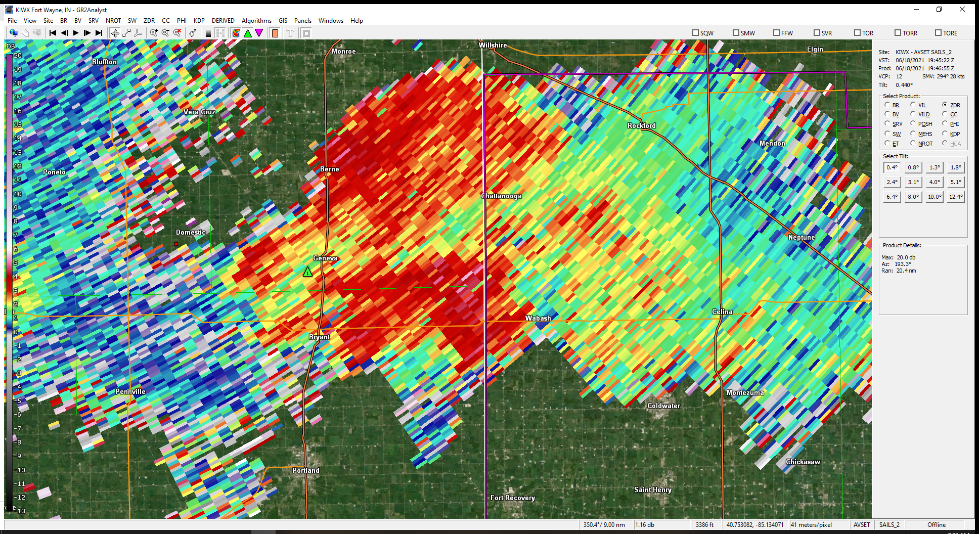 |
| Fig 1. 0.5 degree base reflectivity from KIWX radar ~ 3:54PM EDT | 0.5 degree storm relative motion (SRM) from KIWX radar ~3:54PM EDT | 0.5 degree Correlation Coefficient (CC) from KIWX radar ~ 3:54PM EDT | 0.5 deg Diferential Reflectivity (ZDR) Arc from KIWX Radar ~3:46 pm EDT |
Storm Reports
..TIME...   ...EVENT...      ...CITY LOCATION...     ...LAT.LON...
..DATE...   ....MAG....      ..COUNTY LOCATION..ST.. ...SOURCE....
            ..REMARKS..

0640 AM     TSTM WND GST     SAINT JOSEPH            42.10N 86.49W
06/18/2021  M43 MPH          BERRIEN            MI   OFFICIAL NWS OBS


0713 AM     TSTM WND DMG     3 SW BRISTOL            41.69N 85.86W
06/18/2021                   ELKHART            IN   TRAINED SPOTTER

            3 LARGE OAK TREES SNAPPED.

0720 AM     TSTM WND DMG     2 ESE ELKHART           41.67N 85.93W
06/18/2021                   ELKHART            IN   PUBLIC

            8-10 INCH LIMBS DOWN ON CR16.

0738 AM     TSTM WND GST     2 NW BENTON             41.53N 85.78W
06/18/2021  M55 MPH          ELKHART            IN   ASOS

            ASOS STATION KGSH GOSHEN.

0800 AM     TSTM WND DMG     HILLSDALE               41.93N 84.64W
06/18/2021                   HILLSDALE          MI   EMERGENCY MNGR

            EM REPORTS NUMEROUS TREES AND POWERLINES
            BLOWN DOWN ACROSS THE COUNTY.

0805 AM     TSTM WND DMG     CORUNNA                 41.44N 85.15W
06/18/2021                   DE KALB            IN   PUBLIC

            TREE FELL ONTO A HOUSE AND TOOK DOWN PHONE
            LINES. TIME ESTIMATED FROM RADAR.

0805 AM     TSTM WND DMG     1 NNE GARRETT           41.37N 85.12W
06/18/2021                   DE KALB            IN   PUBLIC

            TREE IN ROADWAY.

0808 AM     TSTM WND DMG     3 ENE AUBURN            41.38N 85.00W
06/18/2021                   DE KALB            IN   PUBLIC

            TREE BLOCKING ROADWAY.

0810 AM     TSTM WND DMG     4 ESE HAMILTON          41.52N 84.85W
06/18/2021                   DE KALB            IN   PUBLIC

            TREE BLOCKING THE WEST LANE OF THE ROADWAY.
            TIME ESTIMATED FROM RADAR.

0820 AM     TSTM WND DMG     AUBURN                  41.36N 85.06W
06/18/2021                   DE KALB            IN   PUBLIC

            TREE THAT FELL INTO WIRES. BOTH ARE IN THE
            ROADWAY. TIME ESTIMATED FROM RADAR.

0827 AM     TSTM WND DMG     1 N SPENCERVILLE        41.30N 84.93W
06/18/2021                   DE KALB            IN   PUBLIC

            LARGE LIMB FELL ONTO A HOUSE, MOTORHOME AND
            POWER LINES. TIME ESTIMATED FROM RADAR.

0828 AM     TSTM WND DMG     3 W FARMER              41.38N 84.68W
06/18/2021                   DEFIANCE           OH   PUBLIC

            REPORT FROM MPING: TREES UPROOTED OR
            SNAPPED; ROOF BLOWN OFF.

0828 AM     TSTM WND DMG     3 W FARMER              41.38N 84.68W
06/18/2021                   DEFIANCE           OH   PUBLIC

            REPORT FROM MPING: TREES UPROOTED OR
            SNAPPED; ROOF BLOWN OFF.

0830 AM     HAIL             2 N FORT WAYNE          41.10N 85.13W
06/18/2021  M0.50 INCH       ALLEN              IN   PUBLIC

            REPORT FROM MPING: HALF-INCH (0.50 IN.).

0830 AM     HAIL             2 N FORT WAYNE          41.10N 85.13W
06/18/2021  U0.50 INCH       ALLEN              IN   PUBLIC

            REPORT FROM MPING: HALF-INCH (0.50 IN.).

0835 AM     HAIL             1 N ROLLING HILLS       41.04N 85.27W
06/18/2021  M0.75 INCH       ALLEN              IN   BROADCAST MEDIA

            DIME SIZE HAIL REPORTED.

0842 AM     TSTM WND DMG     1 SE HARLAN             41.18N 84.90W
06/18/2021                   ALLEN              IN   FIRE DEPT/RESCUE

            POWERLINES DOWN.

0357 PM     TORNADO          2 SSW TRINITY           40.52N 84.86W
06/18/2021                   JAY                IN   TRAINED SPOTTER

            LARGE WEDGE TORNADO REPORTED ON THE GROUND
            MOVING ESE. APPROXIMATELY 200 YARDS WIDE.

0434 PM     HAIL             DUNKIRK                 40.37N 85.21W
06/18/2021  M1.00 INCH       JAY                IN   TRAINED SPOTTER

            DIME TO QUARTER SIZE HAIL.
Environment
 |
 |
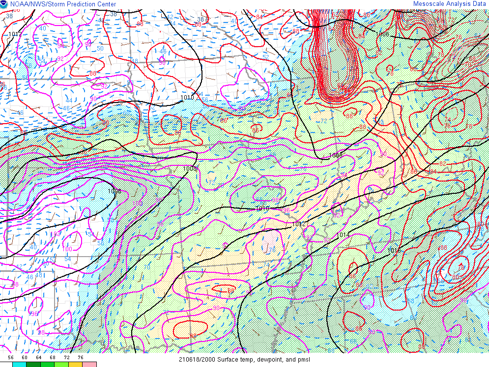 |
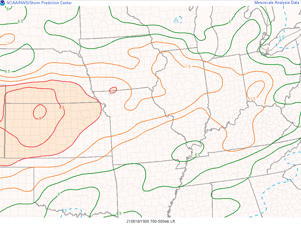
| Figure 1: Mixed Layer CAPE rose to over 3000 J/kg. (Courtesy SPC Mesonanalysis) | Figure 2: Mid level lapse rates rose to over 7 C/km, which is sufficient to produce large hail. Jay county had golf ball and dime sized hail. (Courtesy SPC Mesonanalysis) | Figure 3: Temperatures were in the 80s F and dew points were in the upper 60s to low 70s across the forecast area allowing for a warm and moist environment capable of producing severe weather. (Courtesy SPC Mesonanalysis) |
 |
 |
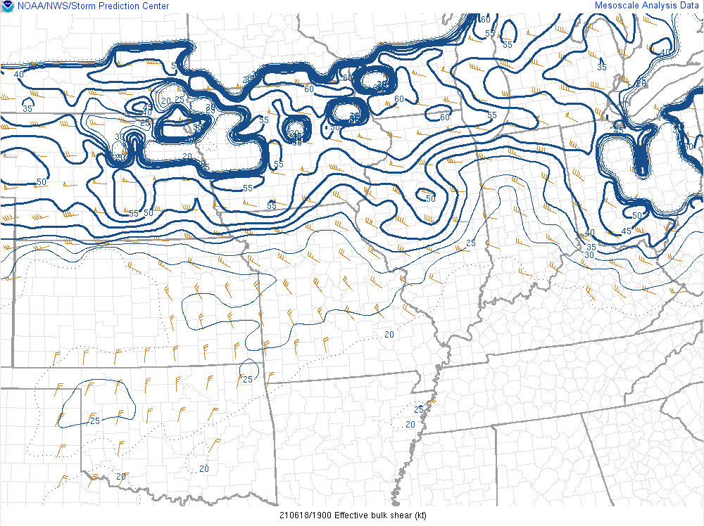 |
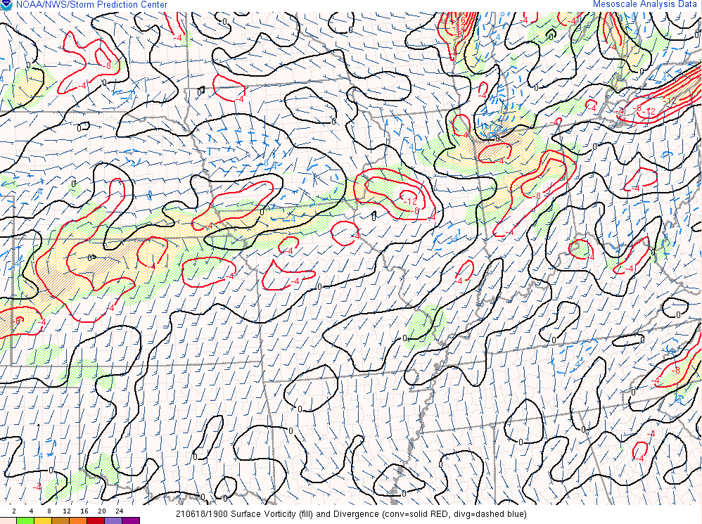
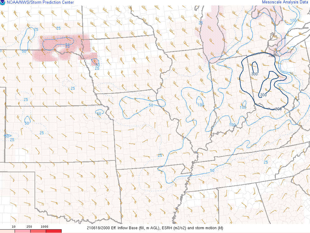
| Figure 4: Plenty of cyclonic curvature to the low level winds and a convergent boundary for storms to ride along produced an environment conducive to rotating storms south of US-30. (Courtesy SPC Mesonanalysis) | Figure 5: Effective helicity rose to over 200 m2/s2 in the location where the rotating cell formed indicating an environment conducive to a rotating updraft. (Courtesy SPC Mesonanalysis) | Figure 6: Effective shear rose to over 35 kts indicating an atmosphere capable of lofting severe hail and sustaining severe thunderstorms. (Courtesy SPC Mesonanalysis) |
 |
 |
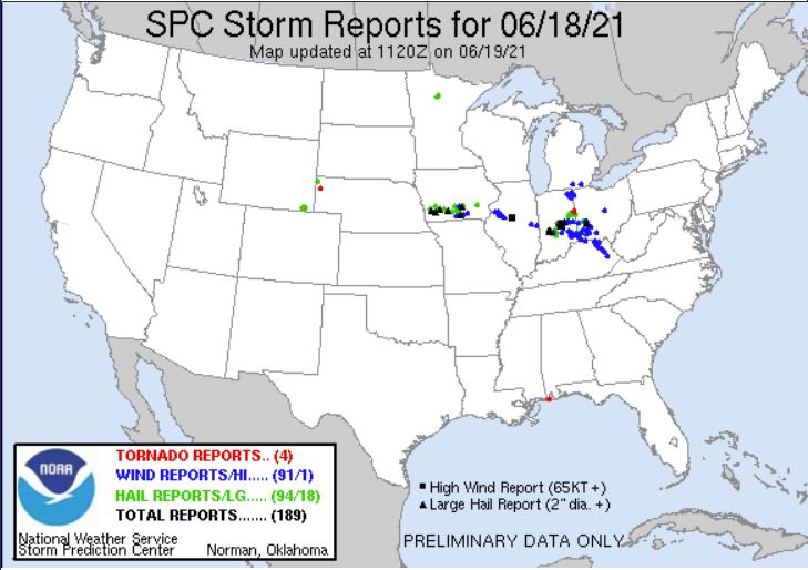 |
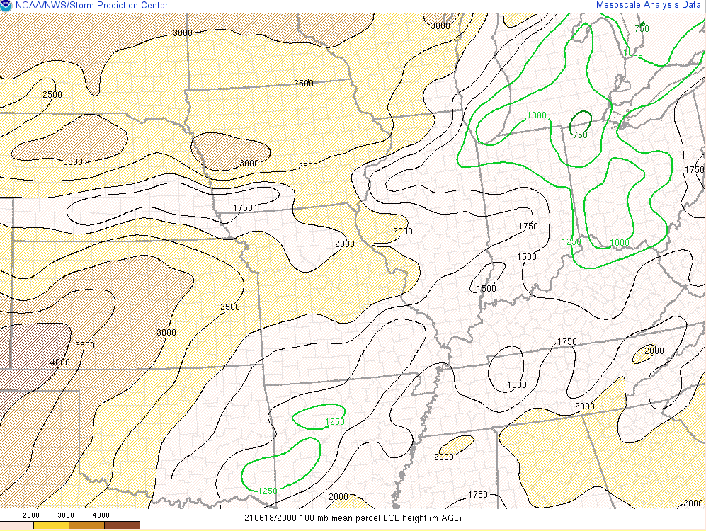
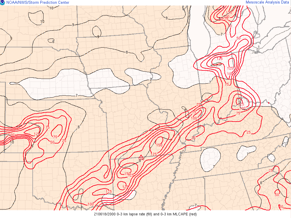
| Figure 7: Lowest condensation levels (LCLs) owe to a more buoyant downdraft (RFD). (Courtesy SPC Mesonanalysis) | Figure 8: Low level lapse rates and low level instability (0-3 km). Greater instability in the low levels is favorable for tornadoes. (Courtesy SPC Mesonanalysis) | Figure 9: Storm Reports from SPC Webpage |
 |
Media use of NWS Web News Stories is encouraged! Please acknowledge the NWS as the source of any news information accessed from this site. |
|