Overview
This page is a summary of the severe weather that occurred in the afternoon and overnight hours of June 20th, 2021 across the IWX CWA, which includes southwest Lower Michigan, northwest Ohio, and Northern Indiana. As of 430 pm EDT June 21, 2021, two EF-1 tornadoes have been confirmed from the early morning hours of June 21, 2021, one across Steuben County Indiana, and one in St. Joseph County Indiana.Tornadoes:
Damage surveys have concluded, and two EF-1 tornadoes have been confirmed during the early morning hours of June 21, 2021.
Thank you to those who submitted reports, photos, and videos. We greatly appreciate it. We also would like to thank local media and emergency management for their assistance with these surveys.
|
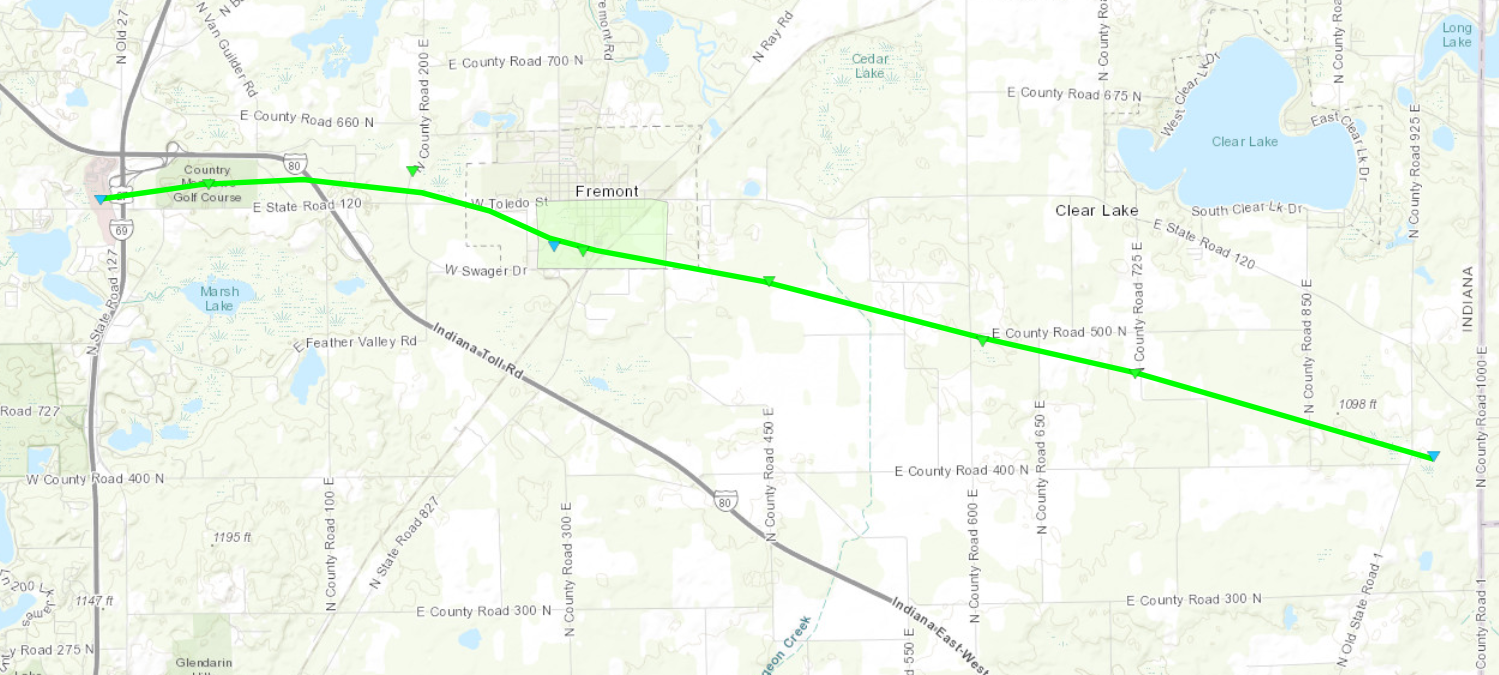
Tornado 1 - 3 SE Lake James
|
||||||||||||||||
|
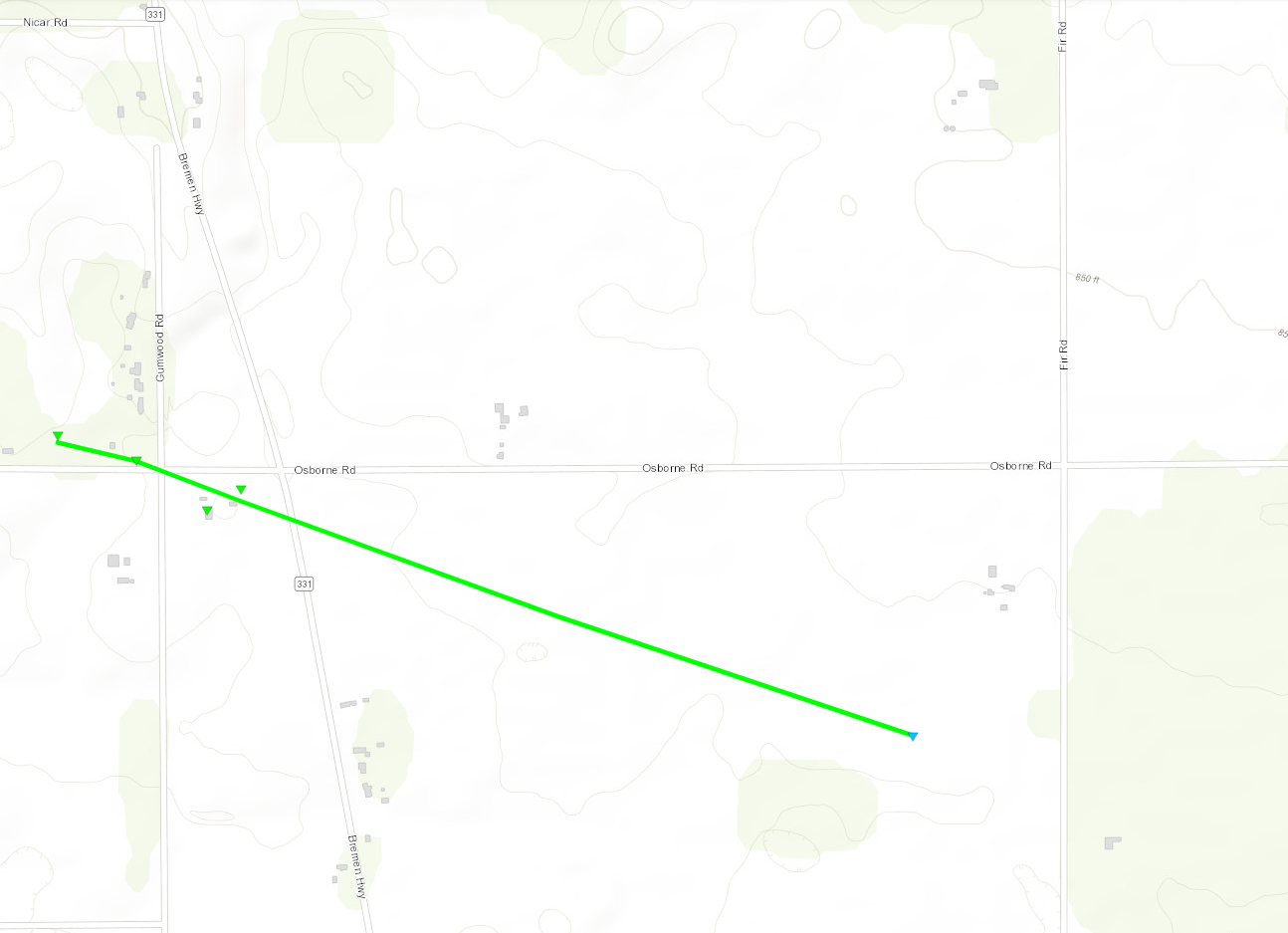
Tornado 2 - 1 S Woodland
|
||||||||||||||||
The Enhanced Fujita (EF) Scale classifies tornadoes into the following categories:
| EF0 Weak 65-85 mph |
EF1 Moderate 86-110 mph |
EF2 Significant 111-135 mph |
EF3 Severe 136-165 mph |
EF4 Extreme 166-200 mph |
EF5 Catastrophic 200+ mph |
 |
|||||
Seiche
Water level fluctuations of 1 to 2 feet were observed on Lake Michigan behind the strong line of storms that went through between 1 am and 2 am EDT on June 21st, 2021. Take a peek at the water levels fluctuating behind the line of storms at Calumet Harbor, IL after 21:00 (9:00 pm CDT) June 20th into June 21st, 2021. A high swim risk and beach hazards statement was issued for dangerous wave and current activity from the evening of June 20th into the morning hours on June 22nd, 2021. A moderate swim risk was issued for the afternoon hours June 22nd, 2021.
 |
 |
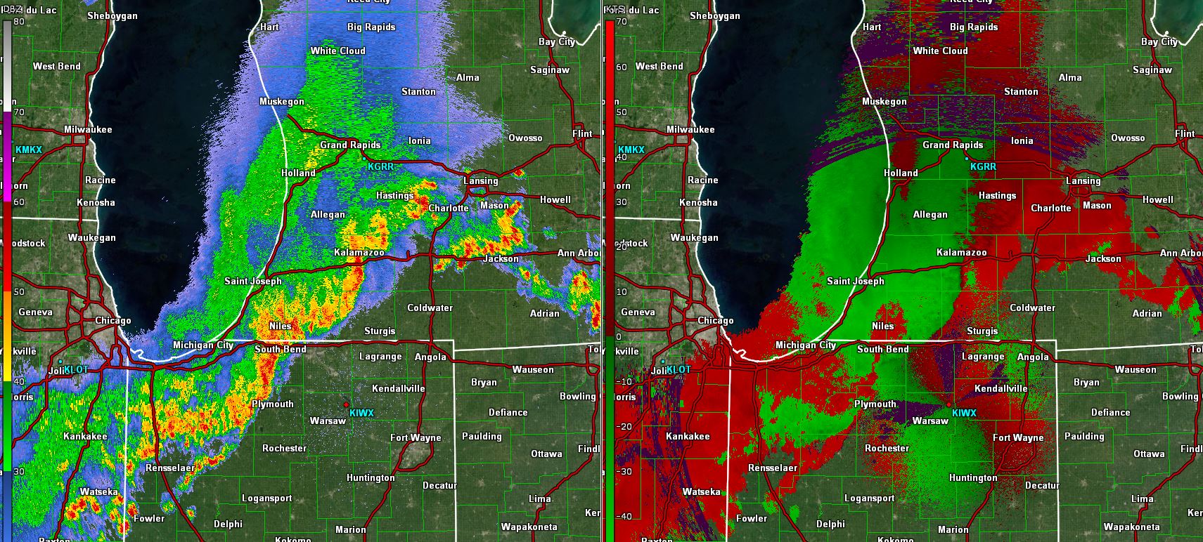 |
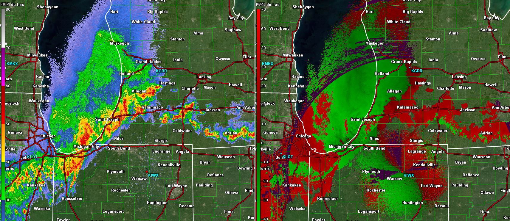
| KIWX Radar Reflectivity/Velocity Image (12:45 AM EDT 6/21/2021) | KIWX Radar Reflectivity/Velocity Image (1:22 AM EDT 6/21/2021) | KIWX Radar Reflectivity/Velocity Image (1:59 AM EDT 6/21/2021) |
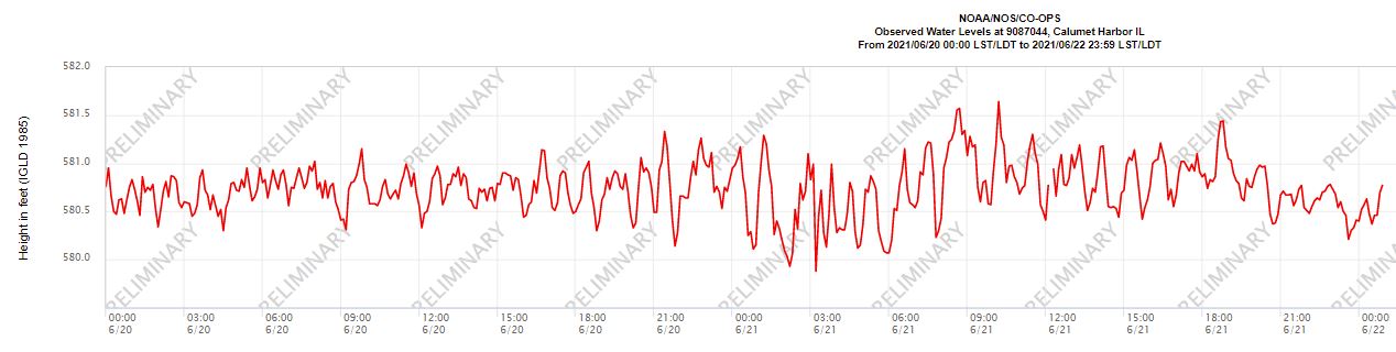 |
| Water levels fluctuating by around 1-2 feet at Calumet Harbor (CMTI3) after the line of strong to severe storms crossed Lake Michigan (LDT, June 20th-21st, 2021) |
Dangerous Waves & Currents
Very strong rip current, longshore, and structural current activity was reported through the day at Silver Beach in St. Joseph, MI the morning of June 21st, 2021. There was even a rescue of a man near the pier, who was caught in a structural current. Waves of 3 to 5 feet were reported along the southeast Lake Michigan shoreline at New Buffalo, Warren Dunes, in Michigan and at Washington Park in Michigan City, IN. Seiche and meteotsunami activity can increase the risk of dangerous current development and increase the strength of those already present-just like the tides do on the ocean. This is why we have two important safety messages when it comes to the Great Lakes:
What are Seiches and Meteotsunamis?
A Seiche (pronounced saysh) is a standing wave oscillation in a lake (enclosed basin) which continues for several hours after the forcing mechanism has ceased. Seiches occur in the Great Lakes every year, usually from May to September. Strong synoptic or mesoscale systems (wind and pressure perturbations) push water to one side of the lake, then once the forcing dies out, the water will wash back to the other side of the lake. The water will continue to oscillate from one side of the lake to the other for hours after the event ends, with the time between high/low water on either side as much as 4 to 7 hours. Imagine shaking a bathtub back and forth for a minute then stopping suddenly-the water will continue to oscillate from one side of the tub to the other for a period of time before settling.
A meteotsunami is a progressive wave limited to a period of 2 minutes to two hours (the tsunami frequency band of wave periods). These are created in a matter of minutes, and the water floods in one direction and does not oscillate back like a seiche does. It has been described as being a storm generated wave that moves towards shore, and is amplified by beach features like slope, coastal morphology, water outlets, shoreline shape, breakwalls, or other coastal features. They are very similar to a seiche in that they are caused by strong and sudden pressure changes over the water, or even a strong synoptic wind event. However, the meteotsunamis are more driven by the sudden pressure change than the strong synoptic winds, and thus are more common with strong to severe thunderstorm activity over the lake. Seiches are also limited to partially or fully enclosed basins, whereas meteotsunamis occur both on the open coast and in enclosed basins. They can also travel for long distances and influence a large range of the coastline. To make it even more confusing, seiches and meteotsunamis can occur together, and often do.
On southern Lake Michigan, significant seiches and meteotsunamis usually occur when an intense northeast-southwest oriented squall line containing very high winds and a large pressure jump moves rapidly (45-60 MPH) southeast across the lake. The seiche and meteotsunami develop often simultaneously as the squall line crosses the lake. The long wave then reflects off the southeastern shore of Lake Michigan and oscillates back and forth across southern Lake Michigan, typically for 3 hours or more (seiche). The impacts of seiches and meteotsunamis on the Great Lakes can pose a large threat to life and property. The meteotsunami and seiche activity is known to either rapidly initiate dangerous current development or strengthen pre-existing currents (for as long as 12 hours after an event ends). The initial wave often catches swimmers and those on boats, or those walking on piers and breakwalls off guard. With major seiches/meteotsunamis (3ft+), water level fluctuations become more impactful at marinas and on docks, piers, and breakwalls. In the most severe cases, boats may end up at the bottom of the lake as the water recedes, or the water may completely inundate the piers and wash any pedestrians into the lake.
Photos & Video
Thanks to those who submitted photos and videos from this event! We greatly appreciate it. Have a video or photo of the storms or damage you want to share with us? Send it to our email at nws.northernindiana@noaa.gov, with a description of where the photos were taken, what time the damage occurred (estimated), and permission for IWX to use the photos/video for social media, our website, and educational purposes.
 |
 |
 |
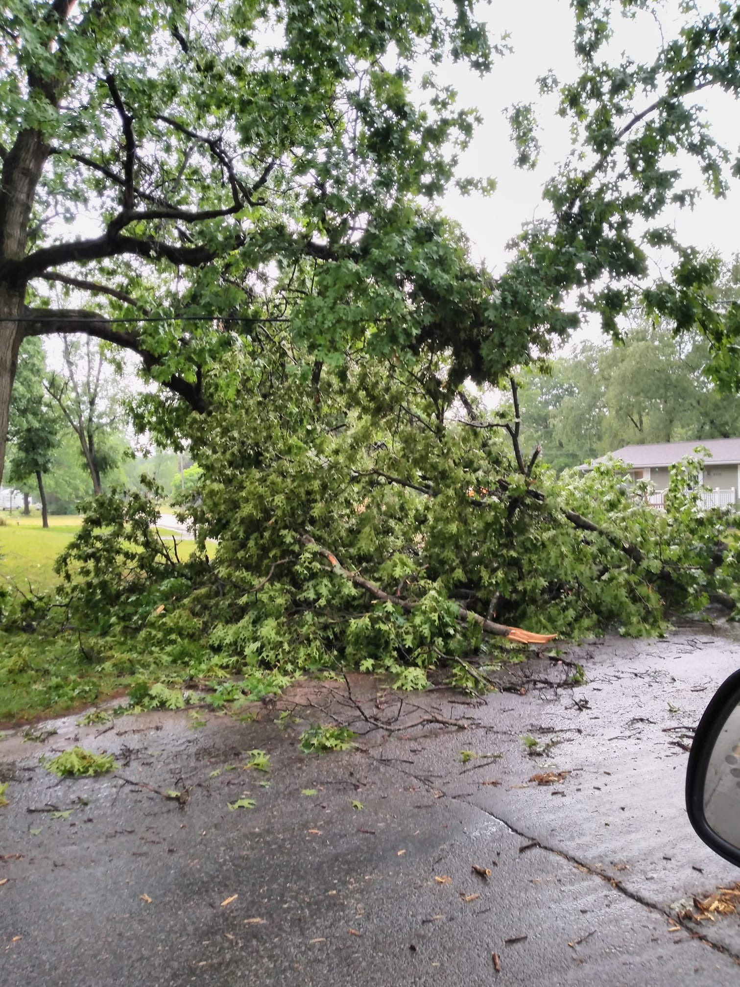 |
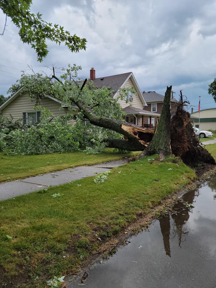
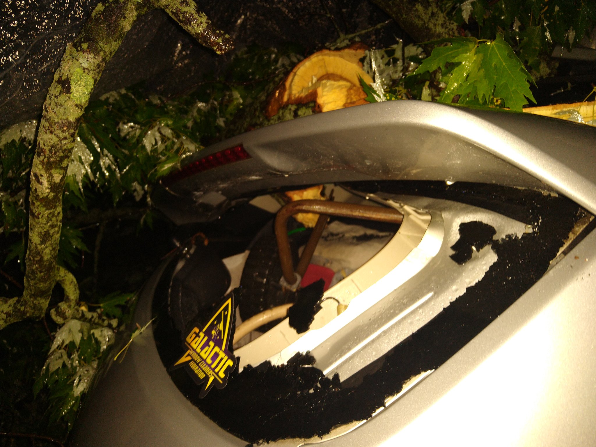
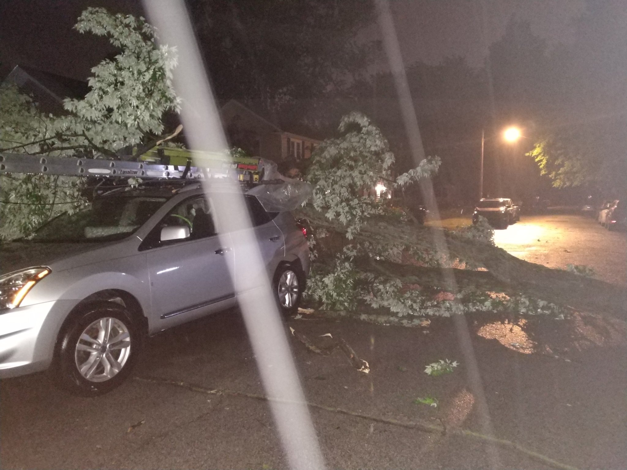
| Tree on House-North Liberty, IN (Photo: Becky Hildreth Wasio) |
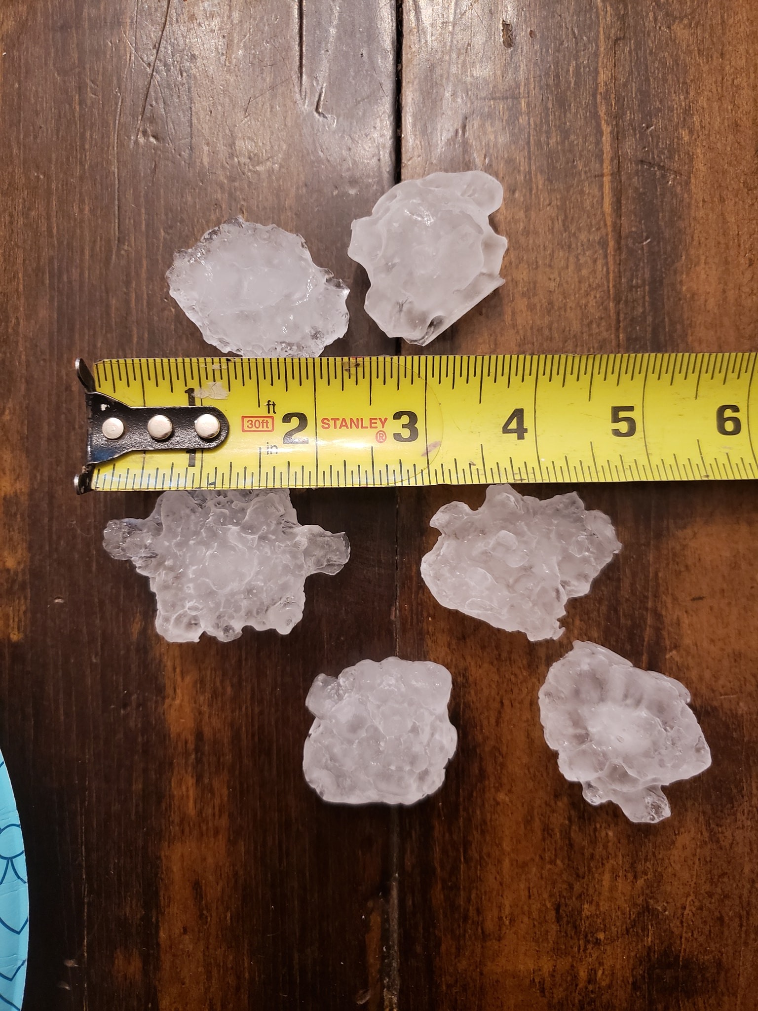
Large Hail in Eau Claire, MI (Photo: Charles Lechlyman) |
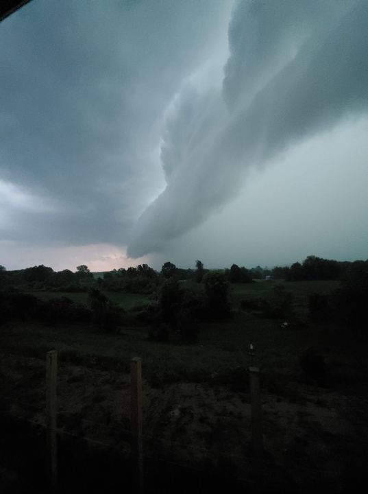
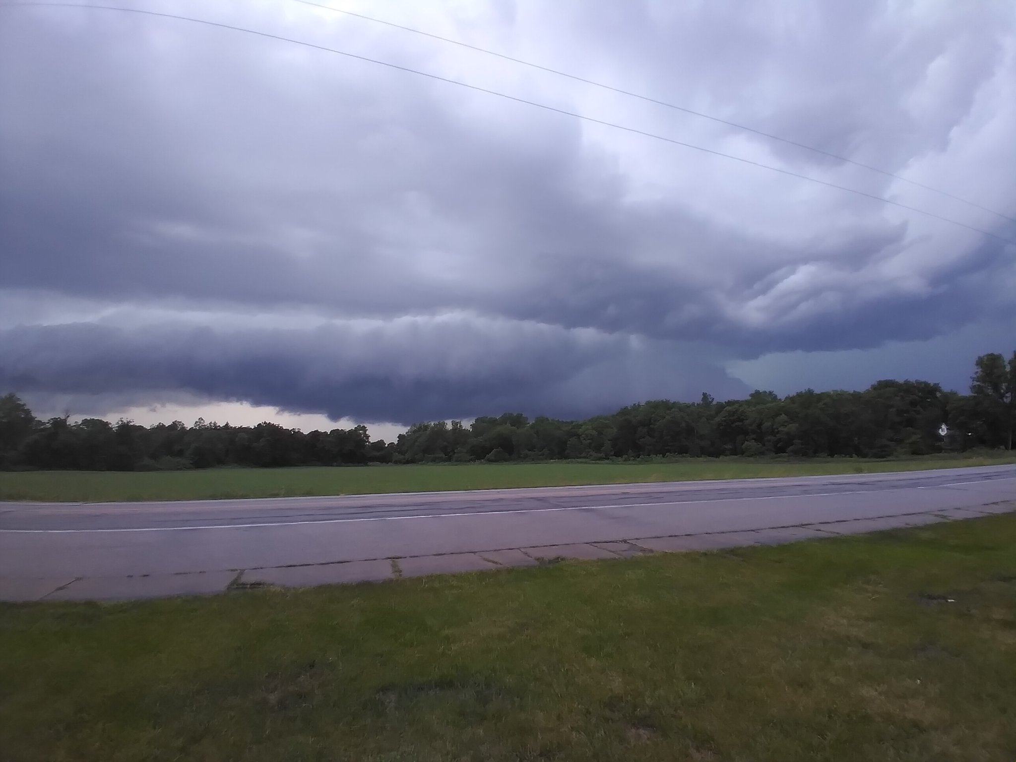
Shelf Cloud in Hillsdale, MI (Photo: Janet M. Stuck) |
Berrien Springs, MI (Photo: Reanna Lennox) |
 |
 |
 |
 |
| Liberty Center, OH (Photo: Chuck Russell III) |
Madison Street in South Bend, IN (Photo: Christine Shouse) |
Madison Street in South Bend, IN (Photo: Christine Shouse) |
Shelf Cloud near Waterloo, IN (Twitter @WeatherScoop) |
.jpeg) |
 |
 |
.jpeg) |
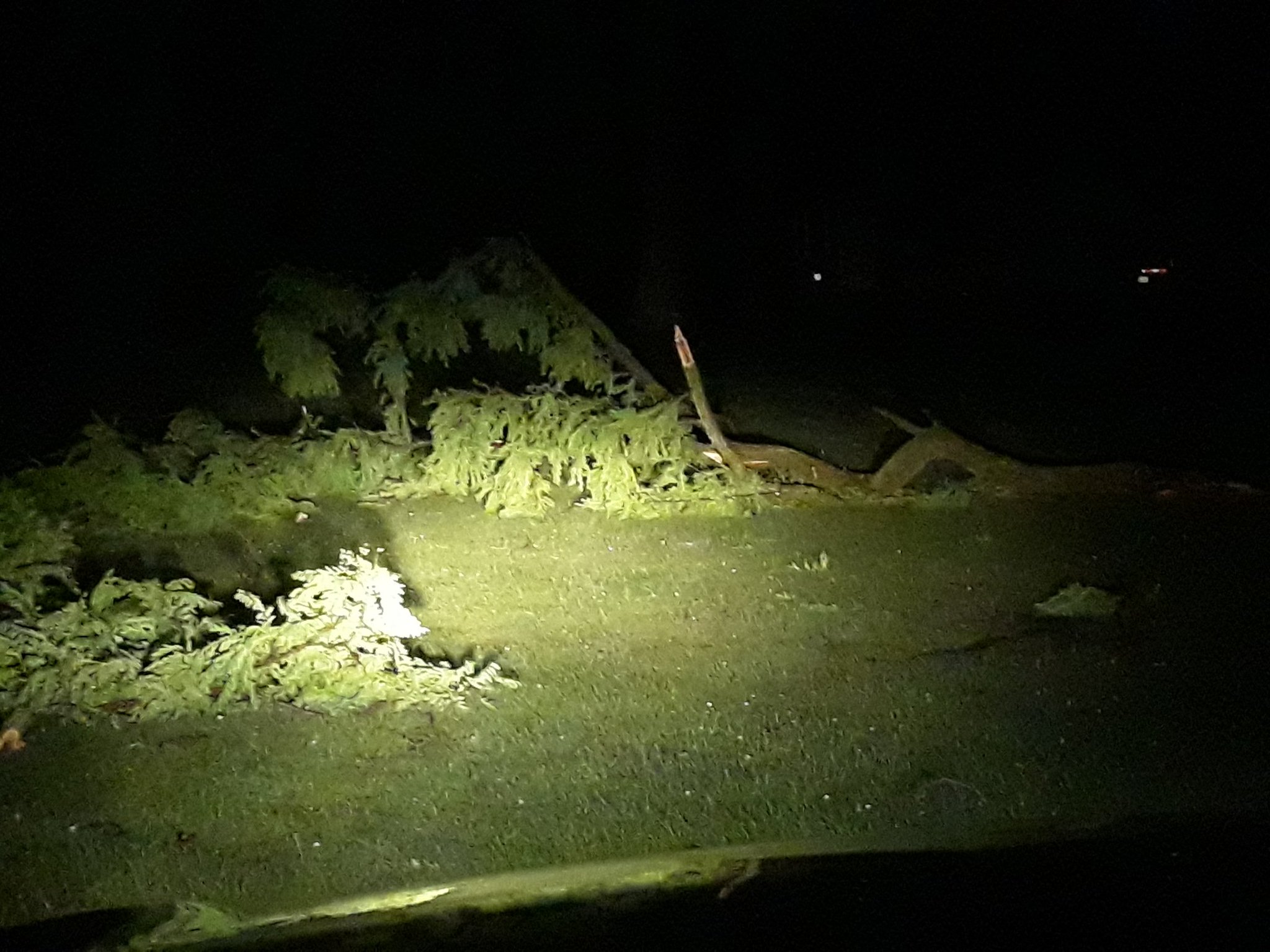
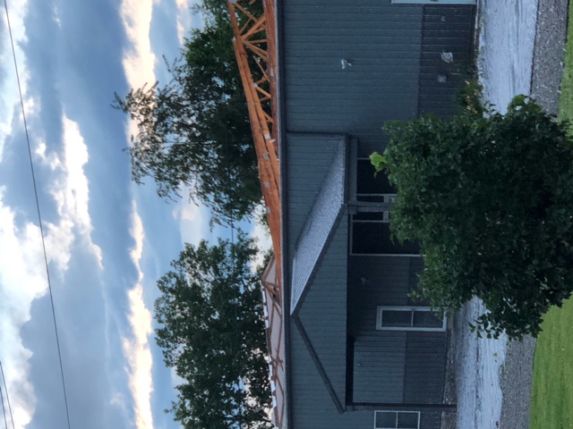
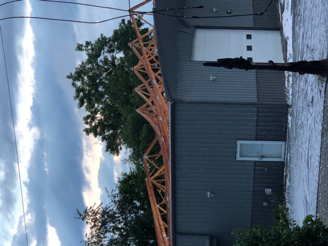
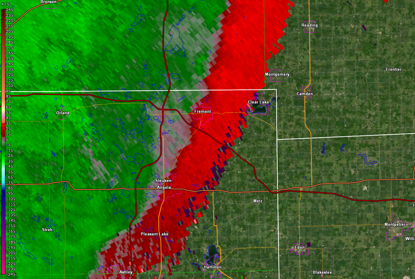
| Fremont, IN (Steuben County, IN EMA) |
Fremont, IN (Steuben County, IN EMA) |
Fremont, IN (Steuben County, IN EMA) |
Fremont, IN (Steuben County, IN EMA) |
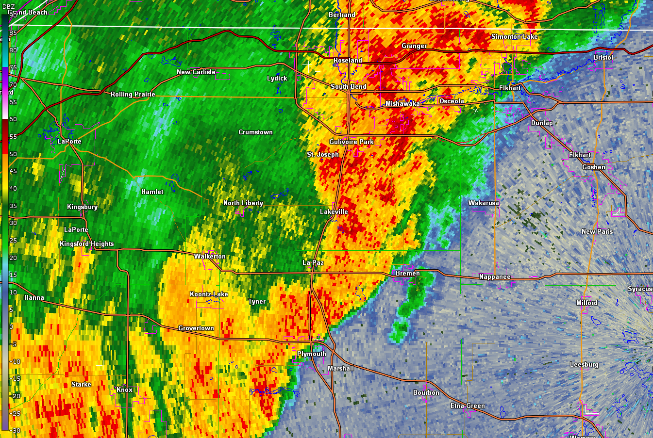
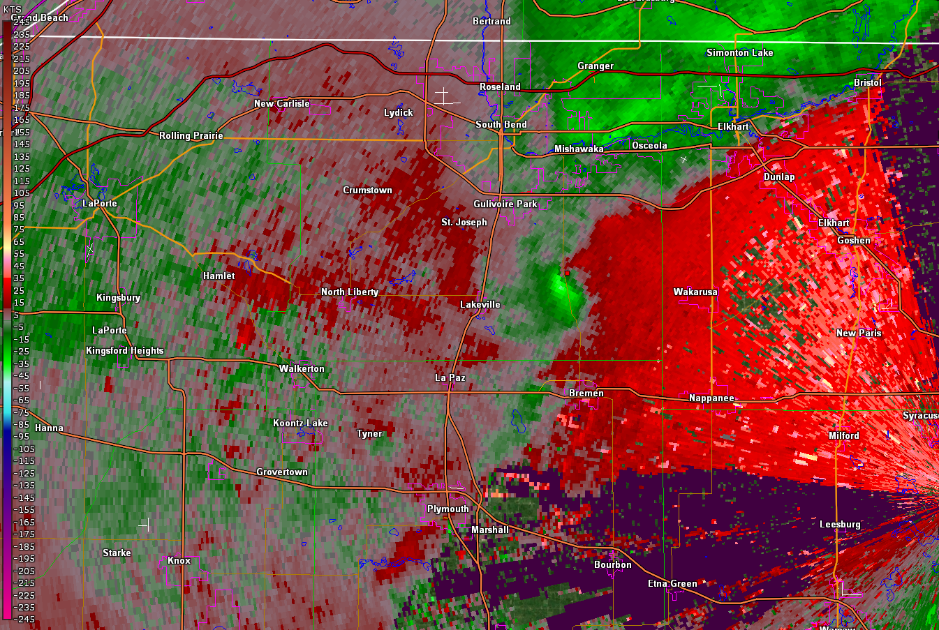
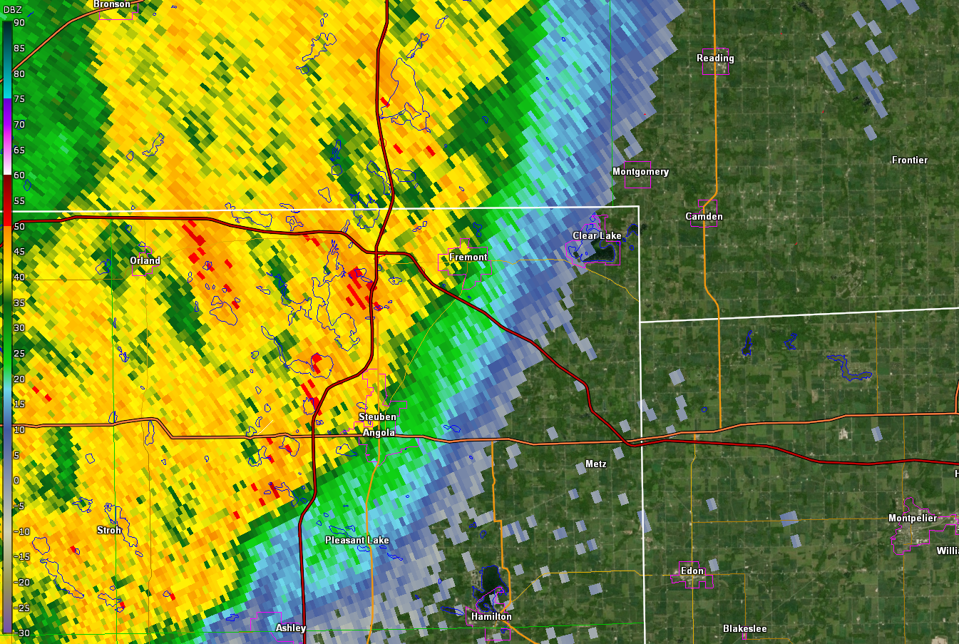
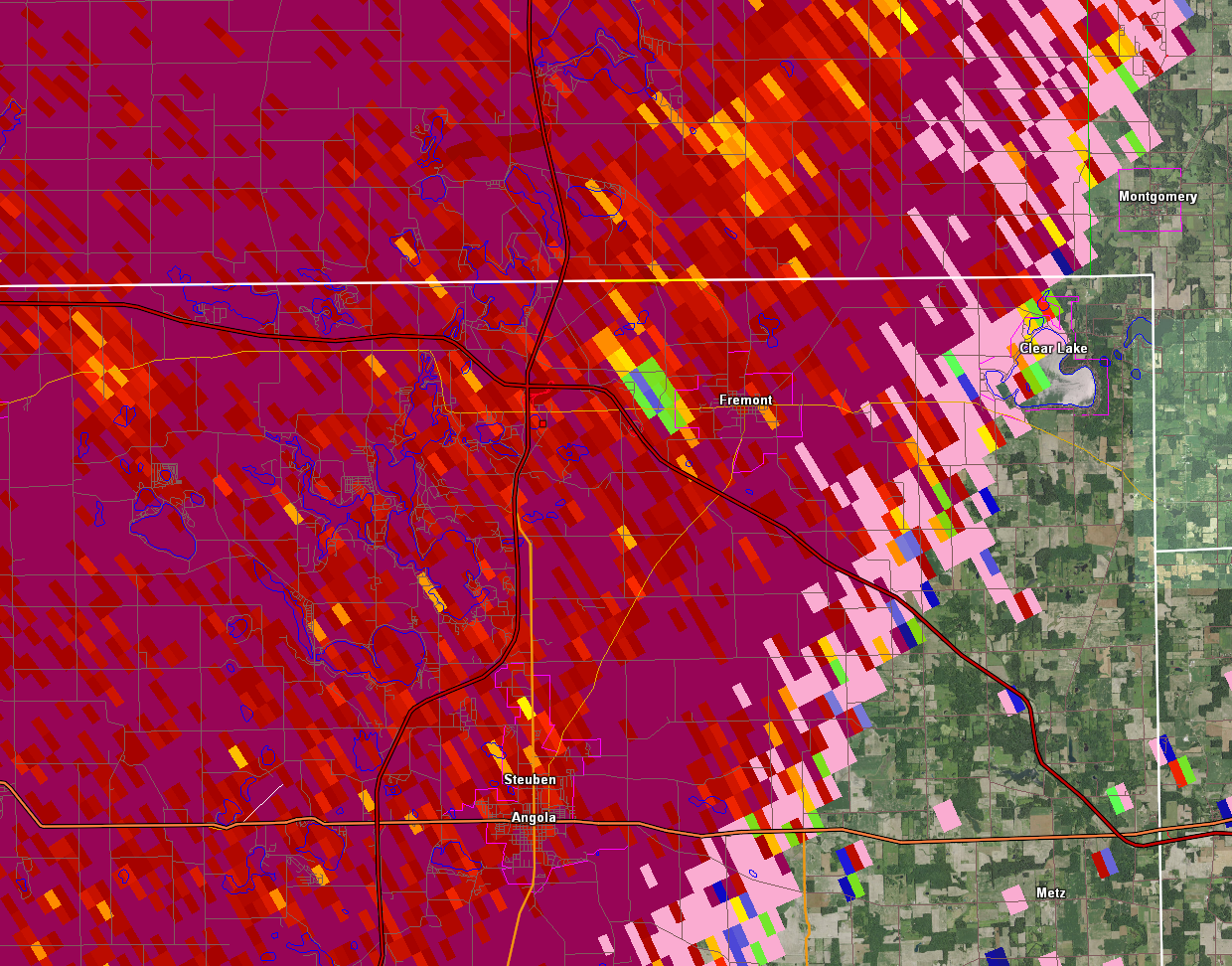
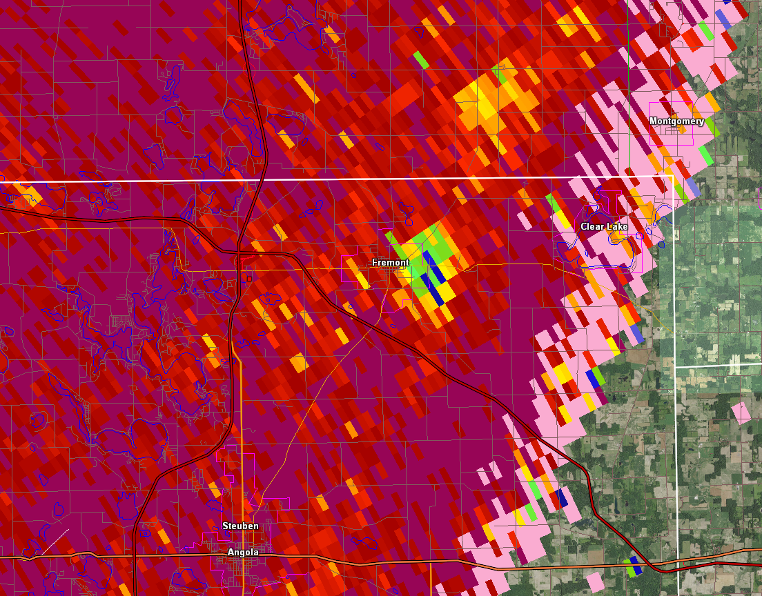
Radar
 |
 |
 |
 |
| 0.5 base reflectivity from KIWX at 208am EDT | 0.5 Storm Relative Motion (SRM) from KIWX at 208am EDT | 0.5 base reflectivity from KIWX at 256am EDT | 0.5 base Storm Relative Motion from KIWX at 256am EDT |
 |
 |
.gif) |
.gif) |
| 0.5 CC Product from KIWX at 256am EDT | 0.5 CC Product from KIWX at 258am EDT | Radar Loop 1 am to 3 am EDT Jun 21 | Radar Loop 3 am to 5 am EDT Jun 21 |
Storm Reports
Hail, Wind, Funnel Cloud, and Flood Reports (tornadoes on tab 1)
NWS Northern Indiana (IWX)
708 AM EDT TUE JUN 22 2021

...HAIL REPORTS...

LOCATION                     SIZE      TIME/DATE       LAT/LON

...INDIANA...

...MARSHALL COUNTY...
ARGOS                        1.00 IN   0639 PM 06/20   41.24N/86.25W

...MICHIGAN...

...BERRIEN COUNTY...
EAU CLAIRE                   2.00 IN   0705 PM 06/20   41.99N/86.30W
1 SE BERRIEN SPRINGS         1.50 IN   0700 PM 06/20   41.94N/86.33W
3 ESE BERRIEN SPRINGS        1.00 IN   0700 PM 06/20   41.93N/86.30W

...CASS COUNTY...
1 N DEWEY LAKE               1.75 IN   0718 PM 06/20   42.07N/86.19W
1 N DEWEY LAKE               0.75 IN   1249 AM 06/21   42.07N/86.19W
SANDY BEACH                  0.75 IN   0715 PM 06/20   42.05N/86.18W
...MEASURED THUNDERSTORM WIND GUSTS...
NOTE: DOES NOT INCLUDE ESTIMATED WIND SPEEDS FROM SURVEYS.

LOCATION                     SPEED     TIME/DATE       LAT/LON

...INDIANA...

...DE KALB COUNTY...
GARRETT                      41 MPH    0805 PM 06/20   41.33N/85.13W

...ELKHART COUNTY...
GOSHEN                       52 MPH    0736 PM 06/20   41.53N/85.78W
JAMESTOWN                    35 MPH    0218 AM 06/21   41.64N/86.04W

...FULTON COUNTY...
ROCHESTER                    47 MPH    0255 AM 06/21   41.07N/86.18W
ATHENS                       37 MPH    0255 AM 06/21   41.07N/86.13W

...KOSCIUSKO COUNTY...
2 N NORTH WEBSTER            39 MPH    0250 AM 06/21   41.36N/85.70W
WARSAW MUNI                  36 MPH    0255 AM 06/21   41.27N/85.83W

...LA PORTE COUNTY...
2.7 W WATERFORD (INDOT)      47 MPH    0144 AM 06/21   41.66N/86.89W
LA PORTE                     39 MPH    0155 AM 06/21   41.57N/86.73W
MICHIGAN CITY KMGC           36 MPH    0135 AM 06/21   41.70N/86.82W

...LAGRANGE COUNTY...
1.9 NW HOWE (INDOT)          39 MPH    0240 AM 06/21   41.75N/85.44W

...MARSHALL COUNTY...
2.6 NW ARGOS (INDOT)         40 MPH    0640 PM 06/20   41.27N/86.27W
PLYMOUTH SITE KC65           39 MPH    0215 AM 06/21   41.37N/86.30W

...ST. JOSEPH COUNTY...
2 NNW GEORGETOWN             60 MPH    0650 PM 06/20   41.76N/86.25W
OSCEOLA                      55 MPH    0640 PM 06/20   41.67N/86.08W
SOUTH BEND INTERNATIONAL AP  48 MPH    0159 AM 06/21   41.70N/86.32W
SOUTH BEND INTERNATIONAL AP  37 MPH    0641 PM 06/20   41.70N/86.32W
0.8 W ROSELAND (INDOT)       36 MPH    0650 PM 06/20   41.72N/86.27W

...WHITE COUNTY...
MONTICELLO - WHITE COUNTY AR 43 MPH    0255 AM 06/21   40.72N/86.77W

...MICHIGAN...

...BERRIEN COUNTY...
4.1 S FAIR PLAIN (MAWN)      37 MPH    0800 PM 06/20   42.02N/86.43W
BENTON HARBOR                37 MPH    0104 AM 06/21   42.13N/86.42W
1 N BENTON HEIGHTS           37 MPH    0111 AM 06/21   42.13N/86.42W

...BRANCH COUNTY...
COLDWATER                    41 MPH    0255 AM 06/21   41.92N/85.03W
COLDWATER                    36 MPH    0815 PM 06/20   41.92N/85.03W

...ST. JOSEPH COUNTY...
THREE RIVERS                 45 MPH    0215 AM 06/21   41.97N/85.60W
STURGIS KIRSCH               41 MPH    0755 PM 06/20   41.80N/85.43W

...OHIO...

...DEFIANCE COUNTY...
DEFIANCE                     36 MPH    0821 PM 06/20   41.33N/84.43W

...FULTON COUNTY...
WAUSEON                      37 MPH    0955 PM 06/20   41.62N/84.13W

...HENRY COUNTY...
NAPOLEON                     42 MPH    0900 PM 06/20   41.39N/84.13W
2 WNW RIDGEVILLE CORNERS     40 MPH    0925 PM 06/20   41.45N/84.30W

...PUTNAM COUNTY...
OTTAWA                       41 MPH    1135 PM 06/20   41.03N/83.98W

...WILLIAMS COUNTY...
2 S HALLOCK                  41 MPH    0339 AM 06/21   41.50N/84.56W

...INDIANA...

...MARITIME STATIONS...
2 NW MICHIGAN CITY           39 MPH    0130 AM 06/21   41.73N/86.91W

...MICHIGAN...
4 NW BRIDGMAN                38 MPH    0115 AM 06/21   41.98N/86.62W

...Flood Reports...

..TIME...   ...EVENT...      ...CITY LOCATION...     ...LAT.LON...
..DATE...   ....MAG....      ..COUNTY LOCATION..ST.. ...SOURCE....
            ..REMARKS..

0744 PM     Flood            2 W Dunlap              41.64N 85.97W
06/20/2021                   Elkhart            IN   Public

            Report from mPING: Minor Street/road flooding

...Funnel Cloud Reports...
Notes: These unconfirmed funnel cloud reports were called/sent in to the NWS during the event.
We can't verify the reports without pictures/video, but we can see if they correlate to the right location as
far as what we see on radar, what we know about storm structure, and other reports. Darkness at the time made
cloud identification difficult.

Mottville (St. Joseph County, Michigan)
There was some rotation in the storm (about 10 miles to the north), but the observer was unlikely to see that far
in the dark. They were likely seeing a shelf cloud, or SCUD beneath the main cloud base.

0221 AM     Funnel Cloud     1 E Mottville           41.80N 85.74W
06/21/2021                   St. Joseph         MI   Public


0208 AM     Funnel Cloud     1 E Mottville           41.80N 85.74W
06/21/2021                   St. Joseph         MI   Public

3W Springville (LaPorte County, IN)
This report came in with an isolated storm that developed along Lake Michigan. There was rotation at the time on radar,
so a funnel cloud was possible. There were no photos/video to confirm funnel cloud, and no damage was reported from that
area around that time.

1103 PM     Funnel Cloud     3 W Springville         41.68N 86.79W
06/20/2021                   La Porte           IN   Public

Batavia (Near Coldwater in Branch County, Michigan)
There was rotation in this storm at the time/location of these reports. Before NWS IWX received the
funnel cloud reports, they had added a "tornado possible" tag to the severe thunderstorm warning. We
received two separate funnel clouds from two different spotters around 9:50 pm EDT, and decided to issue
a tornado warning based on the observed power flashes and debris flying. However, as of 7 am EDT June 22nd, 2021
we have been unable to confirm with the EMA or spotters any tornado touched down, and reports of damage were lacking which
suggests it was either just a funnel cloud or perhaps a shelf cloud/SCUD along leading edge of the storm.

0953 PM     Funnel Cloud     1 NE Batavia            41.92N 85.09W
06/20/2021                   Branch             MI   Trained Spotter

            Reported a possible tornado (couldnt see
            well in the dark). He mentioned he saw power
            flashes and debris flying.

0950 PM     Funnel Cloud     Batavia                 41.91N 85.10W
06/20/2021                   Branch             MI   Trained Spotter

            Reported he saw a tornado as he said that he
            saw the funnel in between lightning
            flashes-and then shortly after saw power
            flashes. Couldnt see anything else in the
            dark, but storm moving ENE.


OBSERVATIONS ARE COLLECTED FROM A VARIETY OF SOURCES WITH VARYING
EQUIPMENT AND EXPOSURES. WE THANK ALL VOLUNTEER WEATHER OBSERVERS
FOR THEIR DEDICATION. NOT ALL DATA LISTED ARE CONSIDERED OFFICIAL.
$$
Rain Reports
PUBLIC INFORMATION STATEMENT
NATIONAL WEATHER SERVICE NORTHERN INDIANA
445 AM EDT TUE JUN 22 2021

...EVENT TOTAL PRECIPITATION REPORTS...

LOCATION                     AMOUNT    TIME/DATE       LAT/LON

...INDIANA...

...ALLEN COUNTY...
MONROEVILLE 0.2 ESE          0.98 IN   0700 AM 06/22   40.97N/84.86W
FORT WAYNE 9.3 W             0.85 IN   0700 AM 06/21   41.05N/85.31W
FORT WAYNE 1.0 NE            0.77 IN   0525 AM 06/21   41.08N/85.13W
HOAGLAND 1.5 SSW             0.73 IN   0700 AM 06/21   40.93N/85.00W
FORT WAYNE INTERNATIONAL AP  0.71 IN   0654 AM 06/21   40.98N/85.18W
FORT WAYNE 8.0 N             0.67 IN   0700 AM 06/21   41.19N/85.11W
FORT WAYNE 5.7 NE            0.59 IN   0700 AM 06/21   41.13N/85.06W
2 E WALLEN                   0.56 IN   0646 AM 06/21   41.16N/85.12W

...DE KALB COUNTY...
GARRETT 0.9 NW               1.25 IN   0634 AM 06/21   41.36N/85.14W
GARRETT                      0.99 IN   0750 AM 06/21   41.33N/85.13W

...ELKHART COUNTY...

ELKHART 3.5 ENE              2.05 IN   0700 AM 06/21   41.70N/85.90W
ELKHART 3.0 SSE              1.85 IN   0700 AM 06/21   41.65N/85.94W
WAKARUSA 2.4 NNE             1.66 IN   0700 AM 06/21   41.57N/85.99W
NEW PARIS 1 SW               1.65 IN   0700 AM 06/21   41.49N/85.84W
1.9 W ELKHART                1.63 IN   1158 PM 06/21   41.68N/86.00W
JAMESTOWN                    1.56 IN   0748 AM 06/21   41.64N/86.04W
SYRACUSE 4.4 NNW             1.50 IN   0700 AM 06/21   41.48N/85.77W
GOSHEN 3.5 NNW               1.50 IN   0703 AM 06/21   41.62N/85.87W
GOSHEN 3 SW                  1.48 IN   0700 PM 06/21   41.56N/85.88W
MIDDLEBURY 2.6 WSW           1.42 IN   0700 AM 06/21   41.66N/85.76W
GOSHEN 4.6 N                 1.41 IN   0655 AM 06/21   41.64N/85.83W
GOSHEN 6.8 NE                1.28 IN   0700 AM 06/21   41.65N/85.75W
LIGONIER 4.3 WNW             1.22 IN   0513 AM 06/21   41.48N/85.67W
GOSHEN                       1.20 IN   0728 AM 06/21   41.53N/85.78W
GOSHEN 3.0 WSW               1.19 IN   0700 AM 06/21   41.56N/85.88W
NAPPANEE 4.8 NE              1.17 IN   0700 AM 06/21   41.50N/85.92W
GOSHEN 1.2 SW                1.14 IN   0700 AM 06/21   41.57N/85.85W
GOSHEN 1.4 SSE               1.02 IN   0700 AM 06/21   41.56N/85.83W
GOSHEN 1.8 SE                0.93 IN   0700 AM 06/21   41.56N/85.81W

...FULTON COUNTY...
ROCHESTER 2.4 NW             1.27 IN   0700 AM 06/21   41.09N/86.23W
3 W ROCHESTER                1.21 IN   0745 AM 06/21   41.05N/86.26W
ROCHESTER                    1.09 IN   0700 AM 06/21   41.07N/86.21W
ATHENS                       0.72 IN   0745 AM 06/21   41.07N/86.13W
KEWANNA 4.9 SSW              0.32 IN   0700 AM 06/21   40.95N/86.45W

...HUNTINGTON COUNTY...
HUNTINGTON 0.3 W             1.20 IN   0630 AM 06/21   40.88N/85.51W
HUNTINGTON                   0.98 IN   0735 AM 06/21   40.85N/85.45W
2 NNW HUNTINGTON             0.83 IN   0745 AM 06/21   40.91N/85.53W
HUNTINGTON 2NE               0.79 IN   0748 AM 06/21   40.93N/85.41W
HUNTINGTON 2 NW              0.77 IN   0738 AM 06/21   40.93N/85.55W
WARREN 4.9 NNE               0.74 IN   0600 AM 06/21   40.75N/85.38W
MARKLE                       0.64 IN   0743 AM 06/21   40.82N/85.41W

...KOSCIUSKO COUNTY...

LEESBURG 0.1 WNW             1.47 IN   0600 AM 06/21   41.33N/85.85W
LEESBURG 4.1 W               1.27 IN   0700 AM 06/21   41.33N/85.93W
CROMWELL 2.9 W               1.21 IN   0700 AM 06/21   41.40N/85.67W
SYRACUSE 3.0 ESE             1.21 IN   0700 AM 06/21   41.41N/85.70W
MILFORD 2.7 SSW              1.18 IN   0600 AM 06/21   41.38N/85.87W
MILFORD 0.9 N                1.14 IN   0700 AM 06/21   41.42N/85.85W
NWS NORTH WEBSTER            0.99 IN   1200 AM 06/22   41.36N/85.70W
5.5 NNE WARSAW               0.95 IN   0745 AM 06/21   41.33N/85.77W
WINONA LAKE 0.9 SW           0.91 IN   0630 AM 06/21   41.21N/85.83W
SYRACUSE                     0.89 IN   0205 AM 06/22   41.42N/85.76W
1 SW SEVASTOPOL              0.82 IN   0749 AM 06/21   41.11N/86.04W
1.7 SSW WARSAW               0.67 IN   0746 AM 06/21   41.21N/85.87W
WARSAW 1.4 N                 0.64 IN   0610 AM 06/21   41.26N/85.85W
WARSAW 1.2 NNE               0.61 IN   0700 AM 06/21   41.25N/85.84W
LEESBURG                     0.60 IN   0748 AM 06/21   41.31N/85.72W
LEESBURG 6.7 ESE             0.59 IN   0700 AM 06/21   41.31N/85.72W

...LA PORTE COUNTY...
MILL CREEK 1.9 NNE           1.10 IN   0726 AM 06/21   41.61N/86.52W
WANATAH 4.4 ESE              1.08 IN   0700 AM 06/21   41.41N/86.81W
LA CROSSE 1.2 W              1.03 IN   0700 AM 06/21   41.32N/86.91W
HANNA 1.1 E                  0.98 IN   0700 AM 06/21   41.41N/86.76W
TRAIL CREEK 1 NNW            0.72 IN   0700 AM 06/21   41.71N/86.86W
0.8 W LA PORTE               0.58 IN   1258 AM 06/22   41.61N/86.73W
LA PORTE 6.8 SW              0.55 IN   0700 AM 06/22   41.55N/86.82W
1 W MICHIGAN CITY            0.54 IN   0750 AM 06/21   41.71N/86.90W

...LAGRANGE COUNTY...
LAGRANGE 1.3 ENE             1.24 IN   0700 AM 06/21   41.65N/85.40W
WOLCOTTVILLE 1.1 WNW         1.20 IN   0700 AM 06/21   41.53N/85.39W
LAGRANGE 9.9 E               1.11 IN   0700 AM 06/21   41.65N/85.23W
LAGRANGE 9.4 ESE             0.89 IN   0700 AM 06/21   41.60N/85.24W

...MARSHALL COUNTY...
PLYMOUTH 2.5 WSW             1.22 IN   0500 AM 06/21   41.33N/86.36W
1.2 W PLYMOUTH               1.22 IN   0550 AM 06/21   41.34N/86.34W
PLYMOUTH 0.9 SE              1.03 IN   0700 AM 06/21   41.34N/86.30W
BREMEN 3.9 WSW               0.97 IN   0700 AM 06/21   41.43N/86.23W
TIPPECANOE 0.8 S             0.91 IN   0700 AM 06/21   41.20N/86.11W

...MIAMI COUNTY...
MACY 2.7 SSE                 1.08 IN   0700 AM 06/21   40.92N/86.12W
SANTA FE                     0.90 IN   0749 AM 06/21   40.64N/85.99W
PERU 4.6 SSE                 0.86 IN   0600 AM 06/21   40.70N/86.02W
DENVER 0.5 SSE               0.68 IN   0700 AM 06/21   40.86N/86.07W
2 E BUNKER HILL              0.68 IN   0750 AM 06/21   40.65N/86.06W

...NOBLE COUNTY...
KENDALLVILLE 4.5 NW          1.35 IN   0700 AM 06/21   41.50N/85.31W
KENDALLVILLE 3.2 N           1.19 IN   0616 AM 06/21   41.49N/85.26W
LIGONIER                     1.00 IN   0749 AM 06/21   41.46N/85.59W
ALBION 9.5 SSW               0.82 IN   0700 AM 06/21   41.28N/85.51W
KENDALLVILLE                 0.74 IN   1050 PM 06/20   41.45N/85.23W
1 WSW MERRIAM                0.69 IN   0745 AM 06/21   41.28N/85.47W
ALBION 5.2 SSW               0.62 IN   0600 AM 06/21   41.32N/85.45W


...PULASKI COUNTY...
NORTH JUDSON 5.4 SW          1.07 IN   0700 AM 06/21   41.16N/86.85W
MONTEREY                     0.94 IN   0745 AM 06/21   41.11N/86.52W
1.3 SW ORA                   0.70 IN   0730 AM 06/21   41.16N/86.56W

...ST. JOSEPH COUNTY...
SOUTH BEND                   1.72 IN   0746 AM 06/21   41.64N/86.23W
0.9 W ROSELAND               1.61 IN   0625 AM 06/21   41.72N/86.27W
SOUTH BEND 4.5 SE            1.54 IN   0730 AM 06/21   41.62N/86.22W
SOUTH BEND INTERNATIONAL AP  1.32 IN   0654 AM 06/21   41.70N/86.32W
MISHAWAKA 3.9 ENE            1.31 IN   0610 AM 06/21   41.68N/86.10W
MISHAWAKA                    1.31 IN   0745 AM 06/21   41.65N/86.13W
SOUTH BEND 2.2 NW            1.25 IN   0700 AM 06/21   41.69N/86.30W
MISHAWAKA 2.0 E              1.17 IN   0700 AM 06/21   41.66N/86.13W
GRANGER 2.0 E                1.13 IN   0600 AM 06/21   41.74N/86.10W
NEW CARLISLE                 1.11 IN   0205 AM 06/22   41.66N/86.51W
GRANGER 1.8 ENE              1.06 IN   0700 AM 06/21   41.75N/86.11W
SOUTH BEND 3.3 SSW           0.99 IN   0704 AM 06/21   41.63N/86.29W
OSCEOLA                      0.74 IN   0204 AM 06/22   41.64N/86.06W


...STARKE COUNTY...
KNOX 4.6 SE                  1.70 IN   0700 AM 06/21   41.24N/86.57W
NORTH JUDSON 3.9 SW          1.13 IN   0710 AM 06/21   41.18N/86.83W

...STEUBEN COUNTY...
ANGOLA 1.2 S                 1.72 IN   0600 AM 06/21   41.62N/85.00W
ANGOLA  6.4 NW               1.34 IN   1100 AM 06/21   41.72N/85.08W
ANGOLA 4.1 N                 1.28 IN   0545 AM 06/21   41.70N/84.99W
HUDSON 4.1 NNW               1.26 IN   0600 AM 06/21   41.59N/85.10W
HUDSON 4.6 N                 1.25 IN   0715 AM 06/21   41.60N/85.09W
HUDSON 0.3 SE                1.23 IN   0651 AM 06/21   41.53N/85.08W
ANGOLA 1.7 WNW               1.19 IN   0700 AM 06/21   41.65N/85.03W
ANGOLA                       0.90 IN   0248 AM 06/21   41.66N/85.02W
ANGOLA 8.7 ESE               0.89 IN   0700 AM 06/21   41.61N/84.84W
HAMILTON 1.7 E               0.84 IN   0700 AM 06/21   41.53N/84.89W

...WABASH COUNTY...
WABASH 1.2 SSW               1.19 IN   0600 AM 06/21   40.78N/85.83W
WABASH 1.5 SW                1.14 IN   1100 AM 06/21   40.78N/85.84W
LAGRO 1.2 SSW                1.01 IN   0700 AM 06/21   40.82N/85.73W
LA FONTAINE 1.1 NW           0.88 IN   0600 AM 06/21   40.68N/85.74W
LA FONTAINE                  0.73 IN   0748 AM 06/21   40.66N/85.79W

...WELLS COUNTY...
BLUFFTON                     0.64 IN   0645 AM 06/21   40.74N/85.17W
BLUFFTON 3.6 N               0.62 IN   0700 AM 06/21   40.79N/85.17W
BLUFFTON 1.7 NNE             0.58 IN   0700 AM 06/21   40.76N/85.16W
OSSIAN 2.4 W                 0.44 IN   0700 AM 06/21   40.87N/85.21W

...WHITE COUNTY...
MONTICELLO 0.9 E             0.38 IN   0700 AM 06/21   40.75N/86.75W
BURNETTSVILLE 9.9 NNW        0.32 IN   0100 PM 06/21   40.90N/86.65W

...WHITLEY COUNTY...
COLUMBIA CITY                0.92 IN   0745 AM 06/21   41.25N/85.45W
COLUMBIA CITY 5.4 N          0.86 IN   0700 AM 06/21   41.24N/85.49W
COLUMBIA CITY 7.4 N          0.85 IN   0654 AM 06/21   41.26N/85.50W
COLUMBIA CITY 4.6 S          0.75 IN   0600 AM 06/21   41.09N/85.47W
COLUMBIA CITY 0.5 WSW        0.75 IN   0710 AM 06/21   41.16N/85.49W
TRI-LAKES 3.0 N              0.72 IN   0615 AM 06/21   41.26N/85.49W
4.5 S COLUMBIA CITY          0.72 IN   0745 AM 06/21   41.09N/85.47W
COLUMBIA CITY 1.5 NNW        0.65 IN   0500 AM 06/21   41.18N/85.49W

...MICHIGAN...

...BERRIEN COUNTY...
3.7 S WATERVLIET             2.09 IN   0100 AM 06/22   42.13N/86.25W
BUCHANAN 1.3 WNW             1.88 IN   0600 AM 06/21   41.84N/86.39W
NILES                        1.66 IN   0748 AM 06/21   41.83N/86.27W
SHOREHAM 2.0 SE              1.51 IN   0700 AM 06/21   42.03N/86.49W
BUCHANAN 1.4 ESE             1.50 IN   0700 AM 06/21   41.82N/86.34W
BENTON HARBOR                1.44 IN   0727 AM 06/21   42.13N/86.42W
SAINT JOSEPH                 1.30 IN   0746 AM 06/21   42.05N/86.47W
ST. JOSEPH 1.5 SSE           1.24 IN   0600 AM 06/21   42.08N/86.48W
BRIDGMAN                     1.15 IN   0745 AM 06/21   41.93N/86.57W

...BRANCH COUNTY...
COLON 3.5 SE                 1.95 IN   0645 AM 06/21   41.92N/85.28W

...CASS COUNTY...
NILES 3.5 E                  1.35 IN   0700 AM 06/21   41.84N/86.18W
CASSOPOLIS 9.0 SSE           1.14 IN   0700 AM 06/21   41.79N/85.95W
1 E NILES                    0.61 IN   0204 AM 06/22   41.77N/86.17W

...HILLSDALE COUNTY...
LITCHFIELD 0.3 ENE           2.40 IN   0650 AM 06/21   42.05N/84.75W
OSSEO 2.7 NE                 2.30 IN   1100 AM 06/21   41.90N/84.49W
JEROME                       1.62 IN   0749 AM 06/21   42.02N/84.46W
LITCHFIELD                   1.56 IN   0203 AM 06/22   42.05N/84.75W
HILLSDALE                    1.49 IN   0155 AM 06/22   41.92N/84.58W
JONESVILLE 0.2 WSW           1.39 IN   1100 AM 06/21   42.05N/84.75W
CAMDEN                       1.03 IN   0745 AM 06/21   41.71N/84.65W

...ST. JOSEPH COUNTY...
2.0 SE MENDON                1.97 IN   0700 AM 06/21   41.98N/85.43W
CONSTANTINE 1.9 E            1.90 IN   0700 AM 06/21   41.84N/85.63W
THREE RIVERS 2.4 NE          1.25 IN   0700 AM 06/21   41.97N/85.60W
STURGIS KIRSCH               1.05 IN   0735 AM 06/21   41.80N/85.43W

...OHIO...

...ALLEN COUNTY...
LIMA 2.5 WNW                 1.55 IN   0645 PM 06/21   40.76N/84.16W
ELIDA 1.4 WNW                0.63 IN   0730 AM 06/21   40.80N/84.22W
LIMA 2.7 NE                  0.42 IN   1100 AM 06/21   40.77N/84.08W
DELPHOS 2.3 ESE              0.38 IN   1100 AM 06/21   40.83W/84.30W

...DEFIANCE COUNTY...
DEFIANCE 0.5 E               1.07 IN   0700 AM 06/21   41.28N/84.35W

...FULTON COUNTY...
ARCHBOLD 4.7 NW              1.59 IN   0530 AM 06/21   41.57N/84.36W
FAYETTE 4.3 ESE              1.19 IN   0700 AM 06/21   41.65N/84.25W
SWANTON 4.0 S                1.05 IN   0652 AM 06/21   41.53N/83.91W
TEDROW                       1.05 IN   0745 AM 06/21   41.62N/84.19W
WAUSEON 2.4 SW               0.87 IN   0700 AM 06/21   41.53N/84.17W
WAUSEON 1.8 S                0.70 IN   0700 AM 06/21   41.53N/84.14W

...HENRY COUNTY...
NAPOLEON 4.5 NNW             1.28 IN   1100 AM 06/21   41.46N/84.15W
NAPOLEON 0.6 WSW             0.62 IN   1100 AM 06/21   41.39N/84.14W
2 WNW RIDGEVILLE CORNERS     0.59 IN   0749 AM 06/21   41.45N/84.30W
NEW BAVARIA 2.3 WSW          0.41 IN   1100 AM 06/21   41.19N/84.21W
MCCLURE 3.4 SSE              0.38 IN   1100 AM 06/21   41.33N/83.91W

...PUTNAM COUNTY...
OTTAWA 1.0 N                 0.62 IN   0700 AM 06/21   41.04N/84.04W
OTTAWA 0.7 SSW               0.40 IN   0700 AM 06/21   41.01N/84.05W

...VAN WERT COUNTY...
VAN WERT                     0.58 IN   0745 AM 06/21   40.87N/84.59W

...WILLIAMS COUNTY...
PIONEER 2.3 S                1.14 IN   0600 AM 06/21   41.65N/84.55W
ALVORDTON 0.5 E              1.01 IN   0700 AM 06/21   41.67N/84.42W
EDON 4 S                     0.79 IN   0400 PM 06/21   41.50N/84.77W
BRYAN                        0.54 IN   0750 AM 06/21   41.51N/84.59W


OBSERVATIONS ARE COLLECTED FROM A VARIETY OF SOURCES WITH VARYING
EQUIPMENT AND EXPOSURES. WE THANK ALL VOLUNTEER WEATHER OBSERVERS
FOR THEIR DEDICATION. NOT ALL DATA LISTED ARE CONSIDERED OFFICIAL.

$$
Environment
Sunday Evening: Click here for a satellite loop. This loop broadly shows a Mesoscale Convective Vortex (MCV) moving across Illinois, eventually igniting thunderstorms in northwest Indiana.
Click here for a satellite loop of the full event.
 |
 |
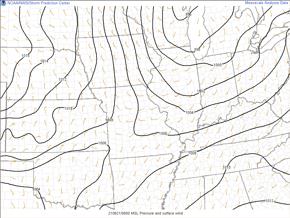 |
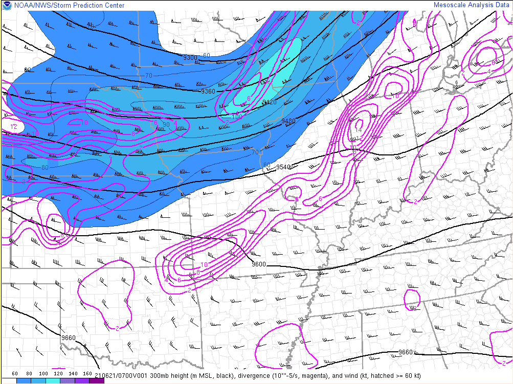
| Figure 1: RAP 1-hr forecast of 300 mb heights/winds/divergence (valid 6/21 3AM EDT). A broad upper trough was moving across western Great Lakes | Figure 2: RAP 1-hr forecast of 850 mb heights/winds/divergence (valid 6/21 at 3 AM EDT). A strong low level jet was nosing into far northern IN and southern Lower MI | Figure 3: Sea level pressure and surface wind analysis from 6/21 at 2 AM EDT. A stalled front/effective warm front near the MI/IN stateline became a focal point for stronger showers and storms late in the night. |
 |
 |
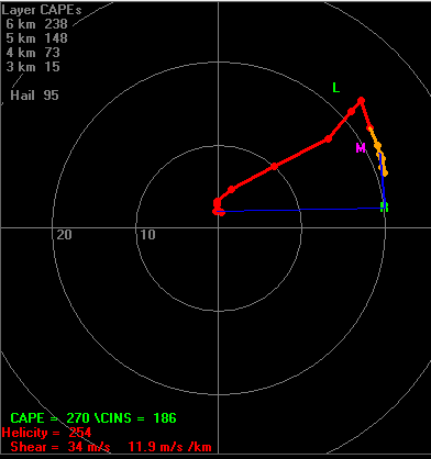 |
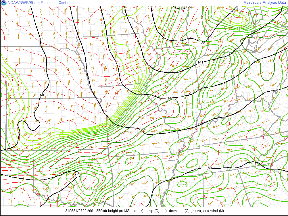
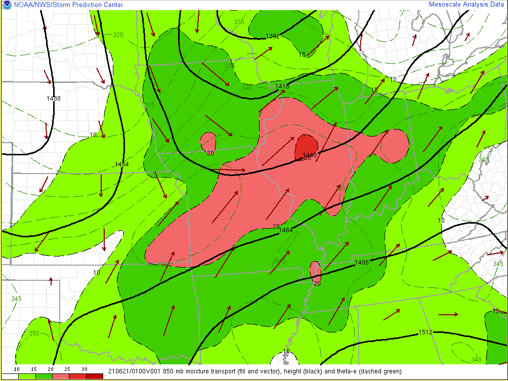
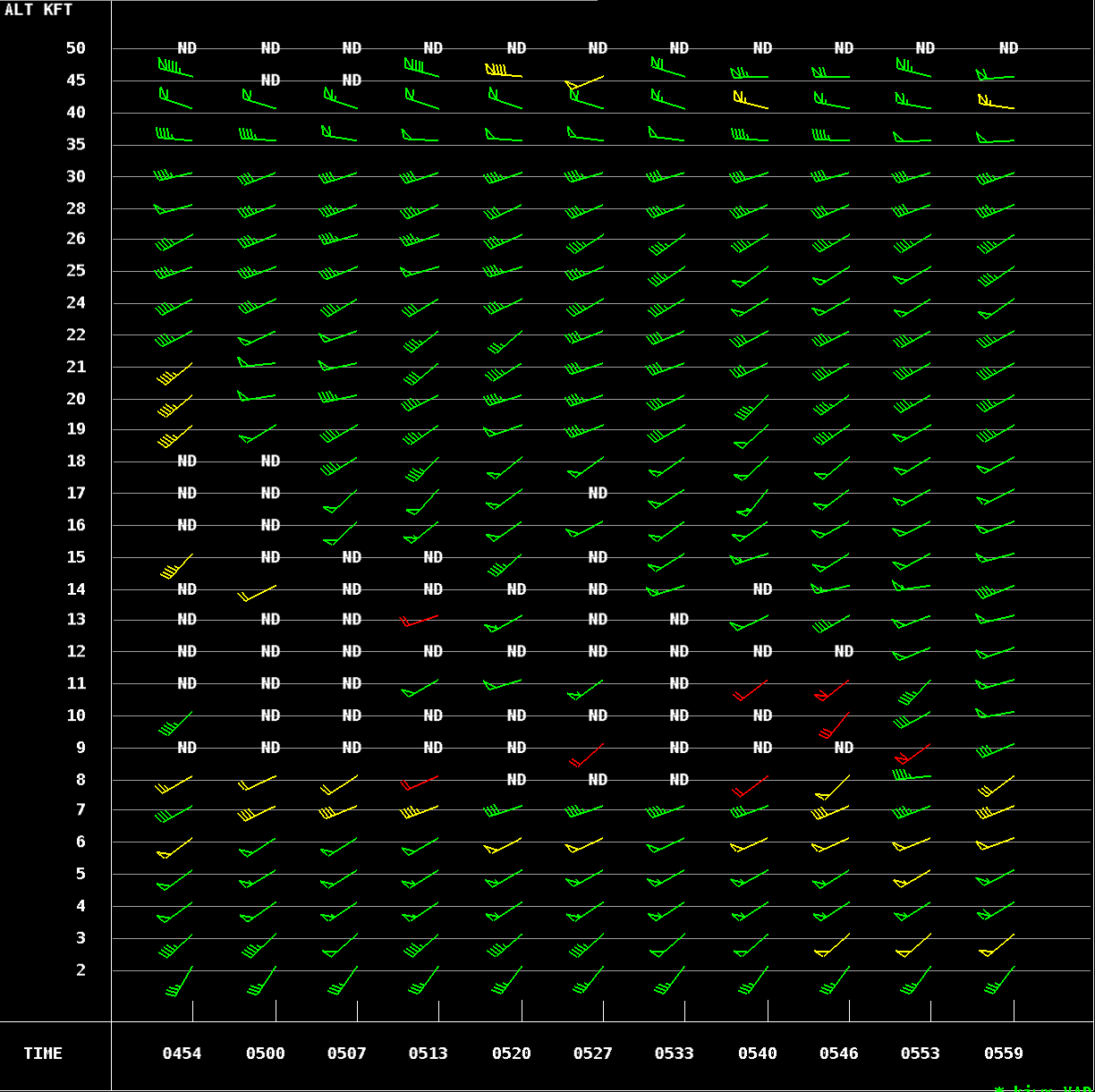
| Figure 4: RAP 1-hr forecast of 850 mb winds/theta-e/and moisture transport (valid 8pm EDT 6/21). Note the strong low level jet nosing into the area. This helped to keep now only favorable wind environment in place during the night but also strong instability. | Figure 5: KIWX VAD wind profile the night of 6/21 indicating that the low level jet had increased to 50-55 knots. Speed shear from the surface to a few thousand feet above ground level is a favorable ingredient for tornadoes. | Figure 6: HRRR 0-hr forecast hodograph (valid 2am EDT 6/21) near Sturgis, MI. The strong speed shear noted in Fig 5 contributed to large hodographs. These large hodographs indicate environments supportive of rotating updrafts/increased tornado potential. |
 |
 |
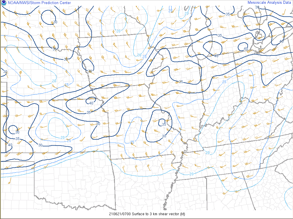 |
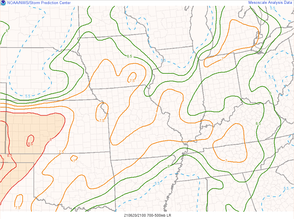
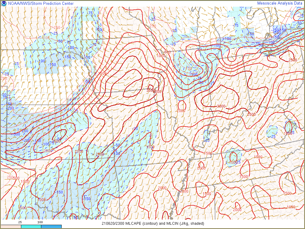
| Figure 7: RAP analysis of mid level lapse rates (valid 5pm 6/20). The steep mid level lapse rates allowed much of the initial storms to be hail producers on the afternoon of June 20th. | Figure 8: RAP analysis of MLCAPE/MLCIN (valid 7pm 6/20). A ridge of instability developed across NW Indiana late in the afternoon on June 20th. Conditions were initially more stable in N Central Illinois (the blue MLCIN area). | Figure 9: RAP analysis of 0-3km shear vectors (valid 3am EDT 6/21). The strengthening westerly shear vectors cutting perpendicular to the thunderstorm bowing segments was conducive for tornado spin-ups along the convective line across far N Indiana/S Lower MI. |
 |
Media use of NWS Web News Stories is encouraged! Please acknowledge the NWS as the source of any news information accessed from this site. |
|


