Overview
Snow overspread northwest Indiana and southwest Lower Michigan during the overnight hours early Monday morning. Snow eventually overspread the remainder of the area across northeast Indiana and northwest Ohio Monday after daybreak. Storm total snow accumulations of 3 to 7 inches were reported as of Monday evening with the greatest snow accumulations across far northwest Indiana into southern Lower Michigan. Precipitation transitioned to a period of freezing drizzle late Monday afternoon. In addition, strong winds were reported with this storm with gusts as high as 30 to 40 mph at times.Wind
Public Information Statement
National Weather Service Northern Indiana
1015 PM EST Mon Jan 28 2019

...HIGHEST WIND GUSTS LAST 24 HRS...

Location                     Speed     Time/Date       Lat/Lon

...Indiana...

...Allen County...
Fort Wayne International Ap  45 MPH    0816 PM 01/28   40.98N/85.19W

...Cass County...
Logansport/cass Cnty Ap      39 MPH    0715 PM 01/28   40.71N/86.37W

...Elkhart County...
Goshen Municipal Airport     40 MPH    0629 PM 01/28   41.53N/85.79W

...Fulton County...
Fulton County Airport        33 MPH    0715 PM 01/28   41.07N/86.18W

...Huntington County...
3 NE Majenica                38 MPH    0723 PM 01/28   40.82N/85.41W

...Kosciusko County...
2 SW Warsaw                  28 MPH    0600 PM 01/28   41.21N/85.87W
James Lake                   28 MPH    0638 PM 01/28   41.31N/85.72W

...La Porte County...
Michigan City                31 MPH    0515 PM 01/28   41.70N/86.82W
La Porte                     30 MPH    0515 PM 01/28   41.57N/86.73W
1 W Michigan City            25 MPH    0553 PM 01/28   41.71N/86.90W

...Lagrange County...
1 ENE Lagrange               28 MPH    0737 PM 01/28   41.65N/85.39W

...Marshall County...
Bremen                       31 MPH    0709 AM 01/28   41.44N/86.16W
Plymouth                     29 MPH    0748 PM 01/28   41.34N/86.31W

...Miami County...
3 W Amboy                    34 MPH    0615 PM 01/28   40.59N/85.98W

...Pulaski County...
3 ENE Vanmeter Park          33 MPH    0630 PM 01/28   41.11N/86.52W

...St. Joseph County...
South Bend International Ap  38 MPH    0739 AM 01/28   41.71N/86.32W
Gulivoire Park               25 MPH    0500 AM 01/28   41.61N/86.24W

...Starke County...
2 ESE Brems                  36 MPH    0755 PM 01/28   41.33N/86.66W

...Wabash County...
Somerset                     36 MPH    0626 PM 01/28   40.66N/85.81W
1 SSE Roann                  31 MPH    0530 PM 01/28   40.89N/85.92W

...White County...
White County Arpt.           36 MPH    0815 PM 01/28   40.71N/86.77W

...Whitley County...
Columbia City                28 MPH    0701 PM 01/28   41.16N/85.49W
2 NE Tri-Lakes               26 MPH    0800 PM 01/28   41.25N/85.45W

...Michigan...

...Berrien County...
Saint Joseph                 38 MPH    0745 AM 01/28   42.10N/86.49W
Southwest Michigan Regional  38 MPH    0610 PM 01/28   42.13N/86.43W
Saint Joseph                 32 MPH    0910 AM 01/28   42.10N/86.49W
Millburg                     25 MPH    0653 PM 01/28   42.12N/86.33W

...Branch County...
Coldwater                    35 MPH    0735 PM 01/28   41.93N/85.05W

...Hillsdale County...
Litchfield                   25 MPH    0818 PM 01/28   42.05N/84.75W

...St. Joseph County...
Sturgis                      31 MPH    0715 PM 01/28   41.81N/85.44W
Three Rivers Municipal Dr Ha 25 MPH    0736 PM 01/28   41.96N/85.59W

...Ohio...

...Defiance County...
Defiance Memorial Airport    37 MPH    0802 PM 01/28   41.34N/84.43W

...Fulton County...
1 NE Tedrow                  27 MPH    1110 AM 01/28   41.62N/84.19W

...Paulding County...
1 NW Oakwood                 32 MPH    0800 PM 01/28   41.11N/84.40W

...Putnam County...
Kalida                       33 MPH    0747 PM 01/28   40.98N/84.20W

...Van Wert County...
3 E Cavett                   42 MPH    1259 PM 01/28   40.95N/84.51W
1 W Middle Point             30 MPH    0723 PM 01/28   40.85N/84.48W

Observations are collected from a variety of sources with varying
equipment and exposures. We thank all volunteer weather observers
for their dedication. Not all data listed are considered official.

$$
Storm Total Snowfall
Storm total snowfall from January 28th, 2019 until 12 pm EST January 29th, 2019.

Storm Reports
PUBLIC INFORMATION STATEMENT
NATIONAL WEATHER SERVICE NORTHERN INDIANA
224 PM EST TUE JAN 29 2019

...48 HOUR STORM TOTAL SNOWFALL REPORTS JANUARY 28TH-29TH 2019...

...INDIANA...

...DE KALB...
AUBURN 0.8 NE          2.1   41.37/85.05

...ELKHART...
GOSHEN 3.0 WSW         4.8   41.56/85.88
ELKHART 4.8 SW         4.0   41.64/86.04
WAKARUSA 2.4 NNE       3.9   41.57/85.99
MILLERSBURG 0.5 SW     3.0   41.52/85.70
GOSHEN 1.2 SW          2.8   41.57/85.85

...FULTON...
ROCHESTER              4.5   41.07/86.23

...KOSCIUSKO...
LEESBURG 0.1 WNW       5.5   41.33/85.85
LEESBURG 6.7 ESE       5.0   41.31/85.72
NWS IWX OFFICAL OB     4.0   41.36/85.70

...LA PORTE...
LA PORTE 1.6 SW        7.3   41.59/86.73
WANATAH 4.4 ESE        6.5   41.41/86.81
LA CROSSE 1.2          5.0   41.32/86.91
WANI3WANATAH           4.4   41.43/86.93
TRAIL CREEK 1.0 NNW    4.0   41.72/86.86

...MARSHALL...
PLYMOUTH               7.4   41.34/86.30
PLYMOUTH 2.5 WSW       4.3   41.33/86.36

...NOBLE...
KENDALLVILLE 4.5 NW    5.0   41.50/85.31
ALBION 3.7 S           2.4   41.34/85.42

...PULASKI...
FRANCESVILLE           4.0   40.99/86.88

...ST. JOSEPH...
SOUTH BEND INT. AP     8.5   41.70/86.32
MISHAWAKA 3.9 ENE      5.4   41.68/86.10
SOUTH BEND 4.5 SE      5.3   41.62/86.22
WALKERTON 5.7 ENE      4.9   41.50/86.39
SOUTH BEND 4.1 NE      4.7   41.71/86.21
SOUTH BEND 4.6 SE      4.0   41.62/86.22

...STARKE...
KNOX                   6.0   41.30/86.62
NORTH JUDSON 3.9 SW    2.0   41.18/86.83

...STEUBEN...
ANGOLA               5.2   41.64/84.99
HUDSON 4.1 NNW       5.1   41.59/85.10
ANGOLA 4.1 N         5.0   41.70/84.99
ANGOLA 1.7 WNW       4.7   41.65/85.03

...WHITLEY...
COLUMBIA CITY 6.9N   2.5   41.26/85.51

...MICHIGAN...

...BERRIEN...
BUCHANAN 1.4 ESE      10.0   41.81/86.34
ST. JOSEPH 1.5 SSE     8.4   42.08/86.48
STEVENSVILLE 1.7 SSE   7.7   41.99/86.51
NILES                  7.5   41.84/86.27
BUCHANAN 1.3 WNW       5.2   41.84/86.39

...CASS...
DOWAGIAC               7.0   41.98/86.13

...HILLSDALE...
LITCHFIELD 0.3 ENE     6.4   42.05/84.75
MONTGOMERY 1.9 SSE     4.0   41.75/84.79

...ST. JOSEPH...
THREE RIVERS           5.7   41.94/85.63


OBSERVATIONS ARE COLLECTED FROM A VARIETY OF SOURCES WITH VARYING
EQUIPMENT AND EXPOSURES. WE THANK ALL VOLUNTEER WEATHER OBSERVERS
FOR THEIR DEDICATION. NOT ALL DATA LISTED ARE CONSIDERED OFFICIAL.

$$
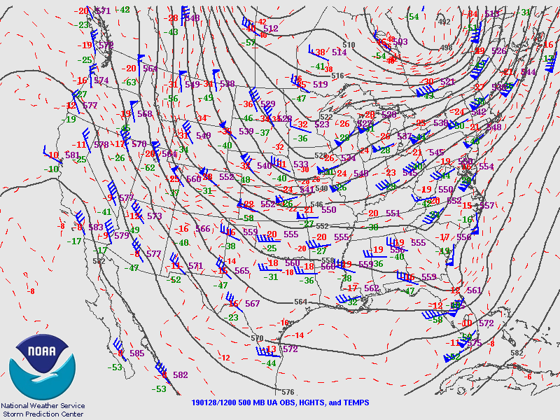
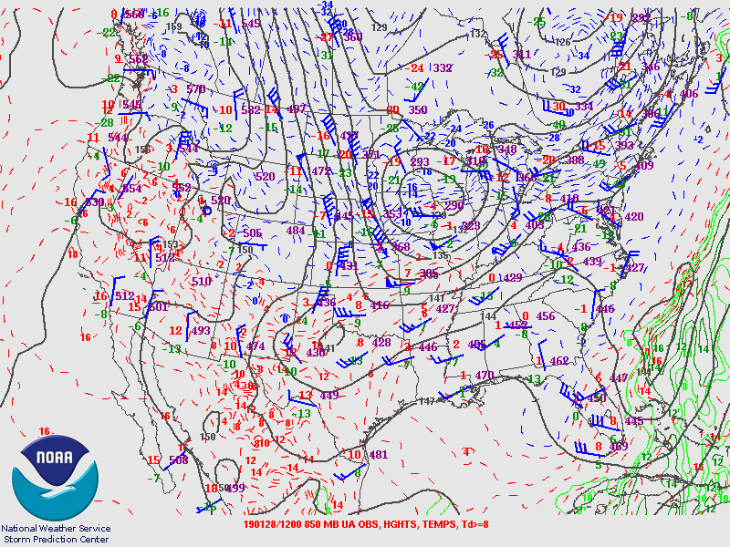
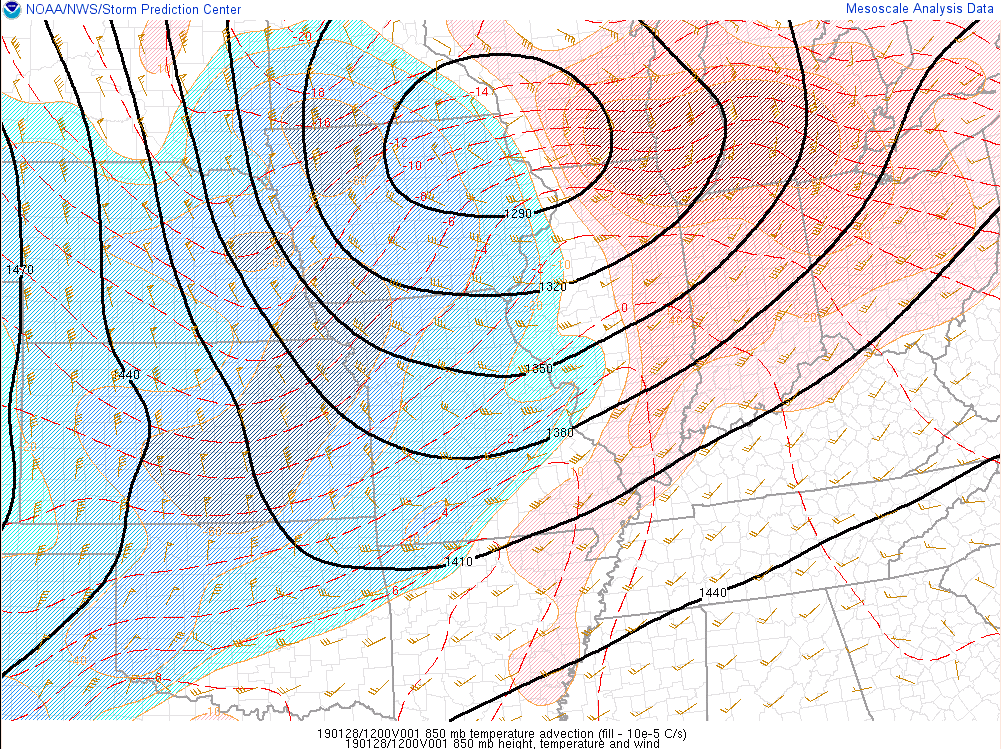
Environment
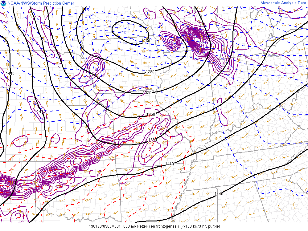
Strong warm advection and frontogenesis were responsible for moderate to heavy snow across the area. A strong low level jet also brought warmth and moisture northward which was a key ingredient for this event.
 |
 |
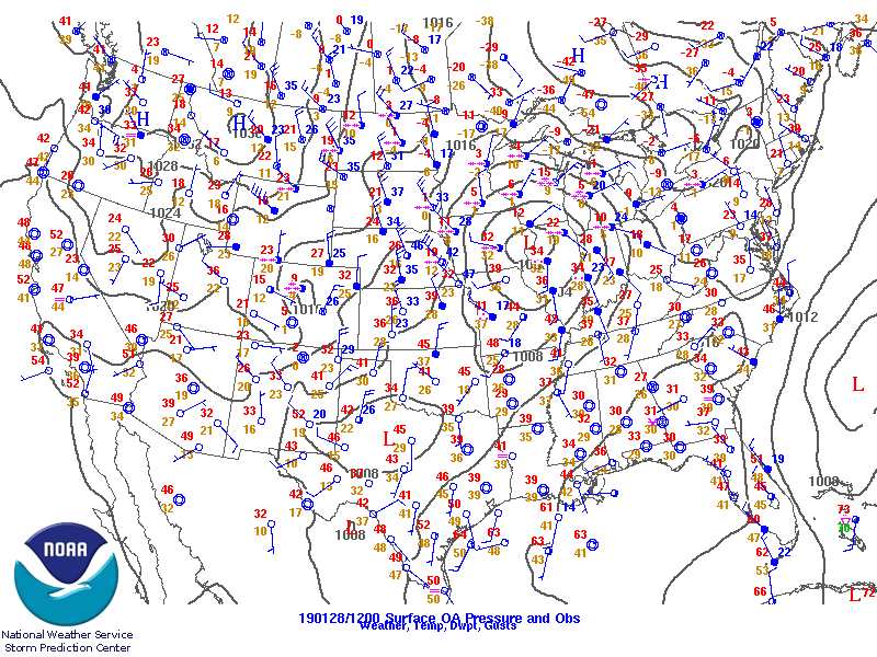 |
| Figure 1: 500 mb heights 1/28/19 7am EST | Figure 2: 850 mb heights 1/28/19 7am EST | Figure 3: Surface map 1/28/19 7am EST |
 |
 |
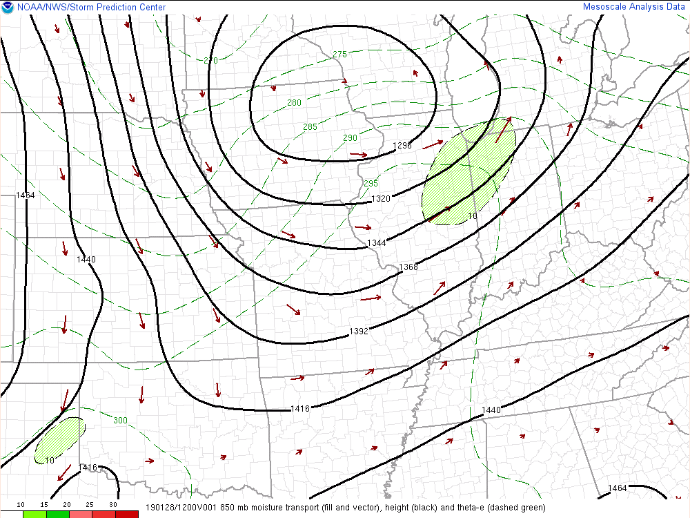 |
| Figure 4: 850 mb temperature advection 1/28/19 7am EST | Figure 5: 850 mb frontogenesis 1/28/19 5am EST | Figure 6: 850 mb moisture transport 1/28/19 7am EST |
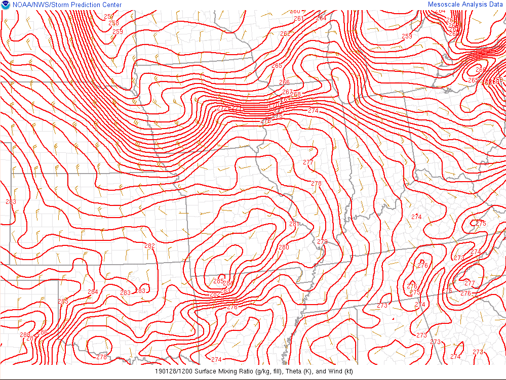 |
| Figure 7: Sfc winds/thta 1/28/19 7am EST |
 |
Media use of NWS Web News Stories is encouraged! Please acknowledge the NWS as the source of any news information accessed from this site. |
|

