A significant heat wave is underway for the Intermountain West, Northern Plains, and Upper Great Lakes, peaking in intensity through midweek and lingering across parts of the Northern Plains and Midwest until this weekend. In southwest Texas, excessive rainfall may bring a risk for potentially life-threatening flash and arroyo flooding through Thursday. Read More >
Overview - Atmospheric River - January 26-29,2021
Heavy Rains and Strong Winds Returned to the Bay Area and the Central Coast
|
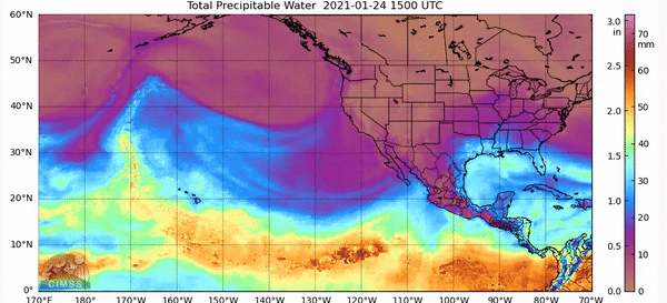
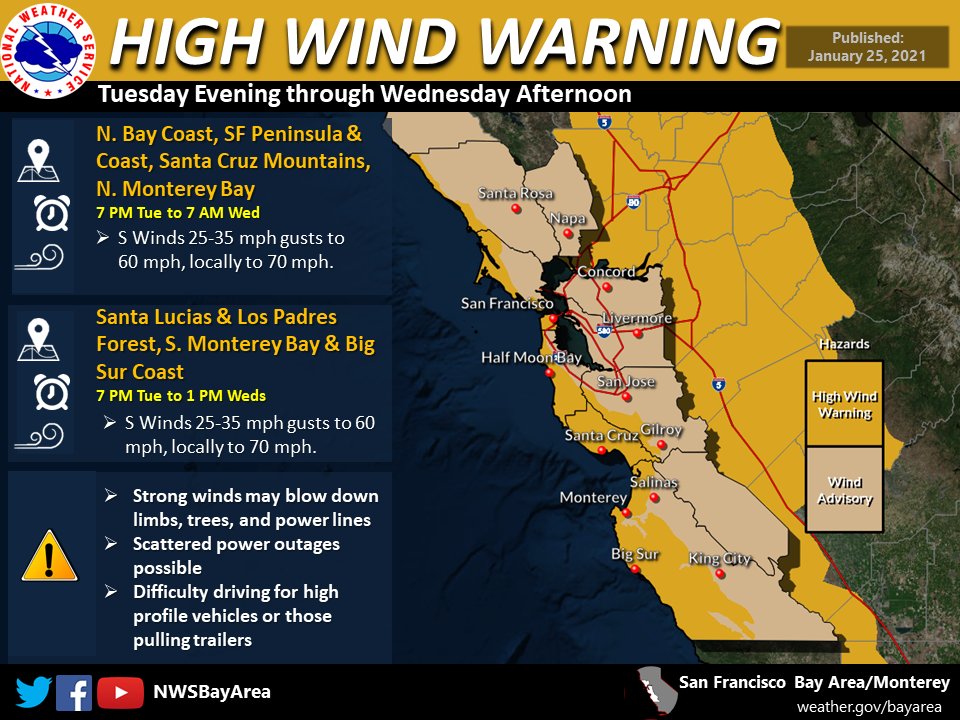
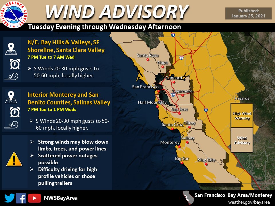
Water year 2020-2021 was off to an active start in terms of storms generating over the Pacific and moving toward America's Western coastline; however, the La Niña pattern in place kept the storm tracks heading toward Seattle, Portland, and the Pacific Northwest. Any rain received near San Francisco was at the tail end of the system. This resulted in quick, weak frontal systems that only brought light showers to the North Bay, with even less to the South Bay and the Central Coast. Only getting weak fronts kept the Bay Area well below normal precipitation levels and dreaming of a major soaking rain. And then the plume of moisture from the tropical Pacific began to move northward and two magical words were added to the Forecast Discussion: "atmospheric river". (AR) Atmospheric River refresher As an upper level trough moved over the Bay Area bringing strong winds and light showers Sunday, January 24, 2021, a ridge of high pressure was sitting over the southeastern Pacific. The anti-cyclonic rotation of the high pressure pushed a large swath of moisture northward toward Alaska. This moisture would ride around the central high and sink southward toward San Francisco January 26-29, 2021. This "colder" AR is atypical for ARs that impact California. ARs are generally "warmer" and have a more direction connection to Hawaii or the sub-tropics resulting in higher snow levels. The approach of such a large amount of moisture prompted Flash Flood Watches in place for most 2020 burn scars around the area as heavy rain could trigger debris flows and mud slides. Light rain reached the North Bay and San Francisco on Tuesday, January 26, 2021, in the evening. Enough lingering cold air resulted in lower snow levels with accumulating snow over the higher peaks in the Bay Area. In fact, snow levels were low enough that low elevation snow occurred over the Northern Sacramento Valley. As another upper level low started to sink southward, pushing the tropical moisture to San Francisco, a narrow cold-frontal rainband (NCFR) developed on the leading edge that prompted Flood Advisories in the North Bay and a Flash Flood Warning over the Walbridge burn scar. The band moved quickly southward prompting further Flash Flood Warnings over the CZU Lightning Complex, River, Carmel, and Dolan burn scars. High Wind Warnings for higher elevations and a Wind Advisory for valley locations were issued as southerly winds ahead of the NCFR intensified. Gusts in the valleys reached 25-35 mph with higher peaks reaching gusts from 60-80 mph Tuesday evening through Wednesday morning. While rain around the Bay Area tapered off behind the NCFR, it slowed over the Big Sur Coast as it began to encounter higher pressure located west of San Diego. The moisture "hose" was turned on and it was pointed straight at the Central Coast. The main band of precipitation then began to retrograde through the day on Wednesday into Thursday once again reaching the Santa Cruz Mountains. The wavering moisture plume resulted in steady moderate to heavy rain from Big Sur to Santa Cruz on Wednesday and Thursday. As the low pressure moved southward down the coast, the main moisture plumed moved south and inland to the Central Valley bringing snow to the high Sierra, leaving scattered showers around the Bay Area and the Central Coast Thursday evening into Friday. This atmospheric river was the strongest storm of the water year thus far. For total precipitation amounts, see the tab below. Despite this heavy rain, the result keeps much of the Bay Area 40% to 60% of normal precipitation for the water year. While it certainly made a chunk in the deficit, summer remains just around the corner with the hope of more rain before the dry season arrives.
CW3E also included a thorough write up here https://cw3e.ucsd.edu/cw3e-event-summary-26-29-january-2021/
Composed by: MMehle and DKing |
|
Gusty Onshore Winds
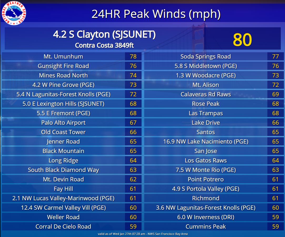
As the leading cold front moved down the California Coastline, winds sharply changed direction to be out of the south-southeast and increased in magnitude. Winds at the valley floors gusted from 25-35 mph with max gusts approaching 40 mph. Higher elevations saw stronger southerly gusts between 60 to 70 mph with Mount Diablo reaching 80 mph gusts!
 |
 |
 |
| High Wind Warning issued for the immediate coast and coastal mountains. | Wind Advisory issued for interior locations. | 24 hour peak wind gusts. |
Public Information Statement
National Weather Service San Francisco CA

..TIME...   ...EVENT...      ...CITY LOCATION...     ...LAT.LON...
..DATE...   ....MAG....      ..COUNTY LOCATION..ST.. ...SOURCE....
            ..REMARKS..

0400 AM     Non-Tstm Wnd Dmg 2 W Rohnert Park        38.35N 122.73W
01/27/2021                   Sonoma             CA   Newspaper

            A tree fell down on a mobile home on Rancho
            Verde Circle in Rohnert Park. Exact time
            unknown.

0400 AM     Non-Tstm Wnd Dmg 1 WSW Guerneville       38.50N 123.00W
01/27/2021                   Sonoma             CA   Newspaper

            A tree crashed through the roof of a home in
            Guerneville overnight, no one was injured.
            Exact timing unknown.

0400 AM     Non-Tstm Wnd Dmg Monte Rio               38.47N 123.01W
01/27/2021                   Sonoma             CA   Newspaper

            Tree crashed through the roof of a home in
            Monte Rio, no one was injured. Exact timing
            unknown.

0138 AM     Non-Tstm Wnd Dmg 2 SE Occidental         38.37N 122.92W
01/27/2021                   Sonoma             CA   Law Enforcement

            LARGE TREE BLOCKING BOTH LANES BY Bohemian
            Hwy / Freestone St.

0706 PM     Non-Tstm Wnd Dmg 1 NE Eldridge           38.34N 122.50W
01/26/2021                   Sonoma             CA   Law Enforcement

            Large tree limb blocking wb lanes of SR-12
            and Madrone Rd.

0114 PM     Non-Tstm Wnd Dmg 5 SSE Lexington Hills   37.10N 121.95W
01/28/2021                   Santa Cruz         CA   Law Enforcement

            Both lanes closed on Soquel San Jose Rd at
            Stetson Rd due to a large eucalyptus tree
            and wires down in the road.

0629 PM     Non-Tstm Wnd Dmg 1 WSW Freedom           36.93N 121.81W
01/27/2021                   Santa Cruz         CA   Law Enforcement

            Branches hit vehicle on Buena Vista Dr at
            Lower Trabing Rd.

0622 PM     Non-Tstm Wnd Dmg 2 SSE Scotts Valley     37.02N 122.00W
01/27/2021                   Santa Cruz         CA   Law Enforcement

            Tree fell blocking entire roadway at 382
            Granite Creek Rd.

0358 PM     Non-Tstm Wnd Dmg Soquel                  36.99N 121.94W
01/27/2021                   Santa Cruz         CA   Law Enforcement

            Large eucalyptus tree down blocking most of
            road at Hardin Way and Soquel Dr.

0642 PM     Non-Tstm Wnd Dmg 1 SSW Aptos Hills-Larki 36.95N 121.83W
01/26/2021                   Santa Cruz         CA   Law Enforcement

            Several large tree limbs in roadway at 788
            Larken Valley Rd.

0814 PM     Non-Tstm Wnd Dmg 2 NW Lexington Hills    37.19N 121.99W
01/27/2021                   Santa Clara        CA   Law Enforcement

            Large tree branch blocking all of east bound
            Bear Creek Rd at SR-17 N.

0515 PM     Non-Tstm Wnd Dmg 2 ENE Santa Clara       37.38N 121.94W
01/27/2021                   Santa Clara        CA   Law Enforcement

            Large tree limb down on US-101 S and Trimble
            Rd.

0515 PM     Non-Tstm Wnd Dmg 1 SW Sunnyvale          37.38N 122.04W
01/27/2021                   Santa Clara        CA   Public

            Tree collapsed onto a parkway in an
            apartment complex.

0845 PM     Non-Tstm Wnd Dmg 1 N Milpitas            37.44N 121.89W
01/26/2021                   Santa Clara        CA   Law Enforcement

            Tree down, 40 feet long, blocking lanes on
            I-680 S and Calaveras Blvd off ramp.

0843 PM     Non-Tstm Wnd Dmg 3 SE San Jose           37.28N 121.81W
01/26/2021                   Santa Clara        CA   Law Enforcement

            Tree down blocking right lane on US-101 N
            and Hellyer Ave on ramp.

0928 PM     Non-Tstm Wnd Dmg 11 SW Portola Valley    37.24N 122.34W
01/26/2021                   San Mateo          CA   Law Enforcement

            Fallen tree blocking lanes at 1007 Ranch Rd.

0915 PM     Non-Tstm Wnd Dmg 2 W Portola Valley      37.38N 122.26W
01/26/2021                   San Mateo          CA   Law Enforcement

            Tree down with live wires at SR-35 and Elk
            Tree Rd.

0902 PM     Non-Tstm Wnd Dmg 4 SSE Portola Valley    37.31N 122.19W
01/26/2021                   San Mateo          CA   Law Enforcement

            Tree down with wires at SR-35 and Page Mill
            Rd.

0530 AM     Non-Tstm Wnd Dmg 8 SSE Salinas           36.58N 121.59W
01/27/2021                   Monterey           CA   Public

            MUD FLOWING ONTO THE RD near 645 River Rd.

0400 AM     Non-Tstm Wnd Dmg 3 SSW Monterey          36.56N 121.90W
01/27/2021                   Monterey           CA   Broadcast Media

            News media reported a large pine tree fell
            into a house on Canada Court in Carmel
            overnight Tuesday. Exact timing not known.

0230 AM     Non-Tstm Wnd Dmg 2 WSW Del Rey Oaks      36.58N 121.86W
01/27/2021                   Monterey           CA   NWS Employee

            Large tree branch down on Deer Forest,
            blocking half of the street.

1100 PM     Non-Tstm Wnd Dmg 1 NNE Del Monte Forest  36.60N 121.94W
01/26/2021                   Monterey           CA   Law Enforcement

            Tree down on road near Bird Rock Rd / Colton
            Rd.

1130 PM     Non-Tstm Wnd Dmg 1 S Piedmont            37.80N 122.23W
01/26/2021                   Alameda            CA   Public

            Down tree branch in driveway and broken
            railing in oakland hills by 580W/13N.

0840 PM     Non-Tstm Wnd Dmg 1 W Hayward             37.63N 122.12W
01/26/2021                   Alameda            CA   Law Enforcement

            Large tree down at SR-92 E and Clawiter Rd
            on ramp.


&&

$$
|
Public Information Statement National Weather Service San Francisco CA 621 AM PST Wed Jan 27 2021 ...HIGHEST WIND REPORTS... Location Speed Time/Date Lat/Lon Santa Cruz 84 MPH 1252 AM 01/27 36.97N/121.97W 4.2 S Clayton (SJSUNET) 80 MPH 1245 AM 01/27 37.88N/121.91W Mt. Umunhum 78 MPH 1200 AM 01/27 37.16N/121.91W Soda Springs Road 77 MPH 1050 PM 01/26 37.17N/121.94W 5.8 S Middletown (PGE) 76 MPH 1020 PM 01/26 38.67N/122.63W Gunsight Fire Road 76 MPH 1140 PM 01/26 38.02N/122.63W Mines Road North 74 MPH 1110 PM 01/26 37.61N/121.67W 4.2 W Pine Grove (PGE) 73 MPH 0700 PM 01/26 38.82N/122.81W 1.3 W Woodacre (PGE) 73 MPH 1100 PM 01/26 38.00N/122.66W 5.4 N Lagunitas-Forest Knoll 72 MPH 0940 PM 01/26 38.09N/122.69W Mt. Alison 72 MPH 1110 PM 01/26 37.50N/121.87W Calaveras Rd Raws 69 MPH 1118 PM 01/26 37.55N/121.84W Las Trampas 68 MPH 1128 PM 01/26 37.83N/122.07W 5.5 E Fremont (PGE) 68 MPH 1020 PM 01/26 37.55N/121.90W Rose Peak 68 MPH 1228 AM 01/27 37.50N/121.74W 5.0 E Lexington Hills (SJSUN 68 MPH 1025 PM 01/26 37.14N/121.89W Old Coast Tower 66 MPH 1250 AM 01/27 36.32N/121.87W Lake Drive 66 MPH 1210 AM 01/27 37.62N/122.45W San Jose 65 MPH 1025 PM 01/26 37.36N/121.91W Black Mountain 65 MPH 0307 AM 01/27 36.38N/120.86W 16.9 NW Lake Nacimiento (PGE 65 MPH 0250 AM 01/27 35.95N/121.00W Jenner Road 65 MPH 0910 PM 01/26 38.47N/123.13W Santos 65 MPH 1050 PM 01/26 37.66N/121.93W Los Gatos Raws 64 MPH 0132 AM 01/27 37.20N/121.95W Long Ridge 64 MPH 1220 AM 01/27 36.43N/121.74W 7.5 W Monte Rio (PGE) 63 MPH 0940 PM 01/26 38.51N/123.14W South Black Diamond Way 63 MPH 1030 PM 01/26 37.94N/121.89W Mt. Devin Road 62 MPH 0200 AM 01/27 36.50N/121.91W Richmond 61 MPH 0928 PM 01/26 37.91N/122.35W 2.1 NW Lucas Valley-Marinwoo 61 MPH 1130 PM 01/26 38.05N/122.60W 4.9 S Portola Valley (PGE) 61 MPH 1020 PM 01/26 37.30N/122.20W Fay Hill 61 MPH 1020 PM 01/26 37.86N/122.12W Point Potrero 61 MPH 0918 PM 01/26 37.91N/122.36W Weller Road 60 MPH 1100 PM 01/26 37.49N/121.86W 3.6 NW Lagunitas-Forest Knol 60 MPH 1110 PM 01/26 38.04N/122.74W 12.4 SW Carmel Valley Vill ( 60 MPH 0200 AM 01/27 36.38N/121.90W Peninsula 59 MPH 1010 PM 01/26 37.33N/122.21W West Side Los Altos Hills 59 MPH 1100 PM 01/26 37.37N/122.17W 14.0 NW Monte Rio (PGE) 59 MPH 0810 PM 01/26 38.60N/123.20W Cummins Peak 59 MPH 1120 PM 01/26 38.03N/122.20W Corral De Cielo Road 59 MPH 1130 PM 01/26 36.53N/121.62W 6.0 W Inverness (DRI) 59 MPH 0820 PM 01/26 38.09N/122.95W Mount Tamalpais RAWS 58 MPH 1136 PM 01/26 37.93N/122.59W 6.0 N Gonzales (PGE) 58 MPH 0920 PM 01/26 36.59N/121.43W Kahler Court 58 MPH 1100 PM 01/26 37.43N/121.81W Cerini Road 58 MPH 0840 PM 01/26 38.23N/122.86W Laureles Grade 57 MPH 0100 AM 01/27 36.53N/121.75W Atlas Peak 57 MPH 0729 PM 01/26 38.47N/122.26W 4.0 SW Pleasanton (PGE) 57 MPH 1130 PM 01/26 37.62N/121.92W Diablo-Blackhawk 57 MPH 1000 PM 01/26 37.84N/121.90W Bodega Bay 57 MPH 0925 PM 01/26 38.32N/123.04W 2.7 SE Kensington (UUNET) 56 MPH 1115 PM 01/26 37.88N/122.25W 3.1 S Highlands (PGE) 56 MPH 1110 PM 01/26 37.48N/122.36W East Bay Mud 56 MPH 0950 PM 01/26 37.78N/122.09W 2.1 W Mill Valley (PGE) 55 MPH 1110 PM 01/26 37.91N/122.58W 12.7 SW Carmel Valley Vill ( 55 MPH 0200 AM 01/27 36.35N/121.88W 0.6 SW Sausalito (PGE) 55 MPH 1250 AM 01/27 37.85N/122.50W 2.8 SE Fairview (PGE) 55 MPH 1040 PM 01/26 37.66N/122.00W Knpt Towers 55 MPH 1150 PM 01/26 37.11N/121.84W Salmon Creek Ranch 55 MPH 1020 PM 01/26 38.35N/123.01W Shulte Road 55 MPH 0140 AM 01/27 36.51N/121.83W Pillar Point Harbor 55 MPH 1158 PM 01/26 37.50N/122.49W Richmond - Brickyard Cove 55 MPH 0810 PM 01/26 37.90N/122.39W Rosita Road 54 MPH 1100 PM 01/26 37.59N/122.50W Spring Valley Raws 54 MPH 1218 AM 01/27 37.56N/122.44W Half Moon Bay 54 MPH 1155 PM 01/26 37.52N/122.50W Oakland Airport 54 MPH 0953 PM 01/26 37.72N/122.23W 3.4 W Lagunitas-Forest Knoll 54 MPH 0910 PM 01/26 38.00N/122.75W 2.0 NE Soledad (PGE) 54 MPH 1010 PM 01/26 36.45N/121.29W Shadowhawk 54 MPH 0930 PM 01/26 37.86N/122.06W Calfire Portable 43 54 MPH 0215 AM 01/27 36.29N/121.85W Woodacre Raws 54 MPH 1151 PM 01/26 37.99N/122.64W Las Trancas 54 MPH 1151 PM 01/26 37.09N/122.27W San Jose 53 MPH 1237 AM 01/27 37.38N/121.81W 3.4 NE Bolinas (PGE) 53 MPH 1130 PM 01/26 37.95N/122.68W 5.2 SW Livermore (PGE) 53 MPH 1130 PM 01/26 37.63N/121.81W Hunter Liggett 53 MPH 0230 AM 01/27 35.95N/121.23W Monte Bello Road West 53 MPH 1120 PM 01/26 37.30N/122.12W Coleman Valley Road South 53 MPH 0940 PM 01/26 38.37N/123.05W Berkeley Marina 53 MPH 0859 PM 01/26 37.86N/122.32W Rodeo Marina 53 MPH 1052 PM 01/26 38.05N/122.33W The Sea Ranch 52 MPH 0751 PM 01/26 38.71N/123.45W Santa Cruz 52 MPH 1246 AM 01/27 36.95N/122.05W 5.8 S Middletown (PGE) 52 MPH 0930 PM 01/26 38.67N/122.63W 5.5 W Woodside (PGE) 52 MPH 0100 AM 01/27 37.39N/122.35W 6.2 NE Greenfield (PGE) 52 MPH 0340 AM 01/27 36.37N/121.15W 4.5 SW Forest Lake (PGE) 52 MPH 0400 AM 01/27 38.76N/122.76W 17.0 S Carmel Valley Vill (P 52 MPH 0230 AM 01/27 36.25N/121.79W Coleman Valley Road West 52 MPH 1000 PM 01/26 38.39N/123.04W Shadowhawk 52 MPH 1030 PM 01/26 37.85N/122.17W Fowler Road 52 MPH 1230 AM 01/27 37.31N/121.75W Boundary 52 MPH 0940 PM 01/26 37.21N/121.77W Piercy Ranch Road 52 MPH 0850 PM 01/26 37.24N/121.76W 4 E Collinsville 52 MPH 0936 PM 01/26 38.08N/121.77W Tomales Bay 52 MPH 0857 PM 01/26 38.18N/122.91W Moss Landing 51 MPH 1251 AM 01/27 36.79N/121.79W San Jose Airport 51 MPH 1053 PM 01/26 37.37N/121.92W 5.6 E Blackhawk (PGE) 51 MPH 0930 PM 01/26 37.81N/121.81W 2.9 N Piedmont (PGE) 51 MPH 0940 PM 01/26 37.87N/122.22W 7.0 E Carmel Valley Vill (PG 51 MPH 1040 PM 01/26 36.53N/121.61W Panoramic Highway 51 MPH 1210 AM 01/27 37.89N/122.56W Snake Road 51 MPH 0920 PM 01/26 38.22N/122.92W 1.5 W Inverness (PGE) 50 MPH 0720 PM 01/26 38.08N/122.87W 1.8 W Portola Valley (PGE) 50 MPH 1000 PM 01/26 37.36N/122.25W 3.2 E East Foothills (PGE) 50 MPH 1240 AM 01/27 37.36N/121.76W Harry Road 50 MPH 0940 PM 01/26 37.22N/121.80W Alcosta Boulevard 50 MPH 0130 AM 01/27 37.75N/121.93W Wilder Hills 50 MPH 1010 PM 01/26 37.85N/122.18W San Leandro Marina 50 MPH 0824 PM 01/26 37.70N/122.19W Sherman M12 50 MPH 0143 AM 01/27 38.06N/121.79W Pebble Beach 49 MPH 0231 AM 01/27 36.57N/121.97W Hayward 49 MPH 0954 PM 01/26 37.67N/122.12W Poverty 49 MPH 1019 PM 01/26 37.44N/121.77W 2.6 SW Monte Sereno (PGE) 49 MPH 0900 PM 01/26 37.21N/122.02W Pier One 49 MPH 0736 PM 01/26 37.80N/122.39W 5.4 W Cloverdale (WWG-SONOMA 48 MPH 0600 PM 01/26 38.80N/123.12W Salinas Airport 48 MPH 1153 PM 01/26 36.67N/121.60W Oak Ridge 48 MPH 0833 PM 01/26 38.74N/123.31W Oakland Middle Harbor, CA 48 MPH 1012 PM 01/26 37.80N/122.33W 8.2 N Healdsburg (PGE) 48 MPH 0740 PM 01/26 38.74N/122.83W 10.5 NE Hearst Castle (PGE) 48 MPH 0430 AM 01/27 35.81N/121.05W 11.8 NW Monte Rio (PGE) 48 MPH 0830 PM 01/26 38.55N/123.20W 4.8 SW Anderson Springs (PGE 48 MPH 0940 PM 01/26 38.73N/122.76W Santa Fe Geothermal 48 MPH 0410 AM 01/27 38.79N/122.75W Bfi Office 48 MPH 1250 AM 01/27 37.51N/122.41W Two Rocks 48 MPH 1020 PM 01/26 38.26N/122.78W Dimeo Lane 48 MPH 0130 AM 01/27 36.97N/122.10W Fremont Hills 48 MPH 1040 PM 01/26 37.62N/121.97W Mound Meadows 48 MPH 0130 AM 01/27 36.51N/121.94W Pittsburg Marina 48 MPH 0224 AM 01/27 38.04N/121.89W Calhoun Street 47 MPH 1020 PM 01/26 37.65N/122.05W Berkeley 47 MPH 0935 PM 01/26 37.86N/122.28W Pacifica 47 MPH 1011 PM 01/26 37.63N/122.49W Byron 47 MPH 1055 PM 01/26 37.83N/121.62W 2.2 W Glen Ellen (PGE) 47 MPH 0810 PM 01/26 38.34N/122.58W 6.4 SW Middletown (PGE) 47 MPH 1030 PM 01/26 38.67N/122.67W La Gloria Road 47 MPH 0240 AM 01/27 36.55N/121.29W 2.8 SW San Juan Bautista (PG 47 MPH 1140 PM 01/26 36.83N/121.58W 16.5 SE Gualala (PGE) 47 MPH 0930 PM 01/26 38.62N/123.29W 1.7 S Temelec (PGE) 47 MPH 1240 AM 01/27 38.23N/122.50W Old Stage Road 47 MPH 0330 AM 01/27 36.67N/121.53W Black Diamond Raws 47 MPH 1028 PM 01/26 37.95N/121.88W Poo107 Loma Chiquita 46 MPH 1110 PM 01/26 37.10N/121.83W Santa Rosa 46 MPH 0733 PM 01/26 38.46N/122.63W San Jose 46 MPH 0849 PM 01/26 37.28N/121.92W Monterey Airport 46 MPH 0254 AM 01/27 36.58N/121.85W Oakland Outer Harbor 46 MPH 0924 PM 01/26 37.81N/122.33W Oakland N Raws 46 MPH 1133 PM 01/26 37.87N/122.22W 6.6 SE Livermore (PGE) 46 MPH 0820 PM 01/26 37.61N/121.70W 2.7 N Woodacre (PGE) 46 MPH 1100 PM 01/26 38.04N/122.65W 7.4 SW Gonzales (PGE) 46 MPH 0120 AM 01/27 36.41N/121.49W Black Diamond Mine 46 MPH 0100 AM 01/27 37.96N/121.89W Blackstone Court 46 MPH 0930 PM 01/26 37.68N/122.04W Klein Road 46 MPH 1220 AM 01/27 37.34N/121.78W Corte Madera Chnl. 46 MPH 0710 PM 01/26 37.93N/122.47W Robles Ave 45 MPH 1000 PM 01/26 38.39N/122.71W Loop Road 45 MPH 1030 PM 01/26 37.51N/122.34W Mountain View 45 MPH 1002 PM 01/26 37.41N/122.10W Cazadero 45 MPH 0916 PM 01/26 38.53N/123.13W Hawkeye Raws 45 MPH 0856 PM 01/26 38.74N/122.84W Pinnacles Raws 45 MPH 0137 AM 01/27 36.47N/121.15W 9.5 SE Carmel Valley Vill (P 45 MPH 0120 AM 01/27 36.39N/121.60W Palo Escrito 45 MPH 0230 AM 01/27 36.41N/121.50W Cienega Road 45 MPH 1210 AM 01/27 36.71N/121.34W Marshall Petaluma Road 45 MPH 0900 PM 01/26 38.16N/122.88W Jolon Hills 45 MPH 0510 AM 01/27 35.88N/120.96W Avila Road 45 MPH 1250 AM 01/27 38.02N/121.99W Garcia Ranch Road 45 MPH 1000 PM 01/26 37.94N/122.17W Union Pacific Rail Rd Bridge 45 MPH 0118 AM 01/27 38.04N/122.12W Mariners Point San Mateo 45 MPH 0944 PM 01/26 37.59N/122.27W Alameda, CA 44 MPH 0754 PM 01/26 37.77N/122.30W Barnaby Raws 44 MPH 0511 AM 01/27 38.03N/122.70W Oakland Inner Harbor 44 MPH 1018 PM 01/26 37.80N/122.29W 4.1 W Saint Helena (PGE) 44 MPH 0450 AM 01/27 38.49N/122.54W 8.3 N Yountville (PGE) 44 MPH 0820 PM 01/26 38.51N/122.34W Jolon Road 44 MPH 0500 AM 01/27 36.11N/121.17W Mill Creek 44 MPH 0940 PM 01/26 37.52N/121.87W 5.3 W Inverness (MTRWFO) 44 MPH 0905 PM 01/26 38.10N/122.94W Near Point Richmond 44 MPH 0854 PM 01/26 37.93N/122.40W 2.7 NW San Jose (SJSUNET) 44 MPH 0935 PM 01/26 37.33N/121.88W Santa Rita 44 MPH 1157 PM 01/26 36.35N/120.60W 1 SE Brisbane 44 MPH 1023 PM 01/26 37.67N/122.37W Treasure Island 44 MPH 0923 PM 01/26 37.83N/122.37W Reservation Road 43 MPH 1200 AM 01/27 36.63N/121.70W Iverson Road 43 MPH 0100 AM 01/27 36.55N/121.44W Pittsburg Marina 43 MPH 1201 AM 01/27 38.03N/121.88W Pacifica 43 MPH 0728 PM 01/26 37.63N/122.49W Alameda 43 MPH 1002 PM 01/26 37.78N/122.30W Santa Rosa 43 MPH 1053 PM 01/26 38.50N/122.82W ONeill Sea Odyssey 43 MPH 0200 AM 01/27 36.96N/122.00W 4.3 N Lagunitas-Forest Knoll 43 MPH 1130 PM 01/26 38.08N/122.67W Los Alamos Road 43 MPH 1020 PM 01/26 38.49N/122.60W Dublin Canyon Road 43 MPH 1120 PM 01/26 37.69N/121.98W Valley Ford Road 43 MPH 1000 PM 01/26 38.30N/122.83W Los Vaqueros Raws 43 MPH 1145 PM 01/26 37.79N/121.73W Alameda Marina 43 MPH 0825 PM 01/26 37.77N/122.29W West Hardin Lane 42 MPH 0840 PM 01/26 38.29N/122.63W I-580 - I-205 42 MPH 1221 AM 01/27 37.74N/121.57W Pacifica 42 MPH 1045 PM 01/26 37.65N/122.47W Davis Point 42 MPH 1124 PM 01/26 38.06N/122.26W Woodside 42 MPH 0945 PM 01/26 37.41N/122.24W Pacific Grove 42 MPH 0228 AM 01/27 36.62N/121.92W Oakland 42 MPH 1032 PM 01/26 37.84N/122.21W Hollister Fire Station 42 MPH 1213 AM 01/27 36.84N/121.36W Novato Fire - Robinhood 42 MPH 0831 PM 01/26 38.11N/122.55W Baylands Nature Center Palo 42 MPH 1037 PM 01/26 37.46N/122.11W Altamont Raws 41 MPH 1212 AM 01/27 37.69N/121.61W Ben Lomond Mountain (raws) 41 MPH 1250 AM 01/27 37.13N/122.17W Hastings Raws 41 MPH 0211 AM 01/27 36.39N/121.55W Hayward 41 MPH 0920 PM 01/26 37.66N/122.05W Pinole 41 MPH 1034 PM 01/26 37.98N/122.26W Hollister Airport 41 MPH 1155 PM 01/26 36.90N/121.42W Palo Alto Airport 41 MPH 0847 PM 01/26 37.47N/122.12W Carquinez Strait 41 MPH 1036 PM 01/26 38.03N/122.13W Big Rock 41 MPH 1133 PM 01/26 38.04N/122.57W 2.6 NW Orinda (PGE) 41 MPH 0950 PM 01/26 37.91N/122.20W Frazier Lake Road 41 MPH 0250 AM 01/27 36.98N/121.42W Oakland Idsm 41 MPH 1030 PM 01/26 37.76N/122.22W Pt Blunt Angel Island 41 MPH 1013 PM 01/26 37.85N/122.42W Parker Flats Cutoff 40 MPH 0250 AM 01/27 36.63N/121.79W Fort Romie 40 MPH 1140 PM 01/26 36.40N/121.34W 7 NNW Livermore 40 MPH 0735 PM 01/26 37.79N/121.79W Livermore 40 MPH 0942 PM 01/26 37.66N/121.70W Brentwood 40 MPH 1150 PM 01/26 37.97N/121.72W Carmel 40 MPH 1246 AM 01/27 36.55N/121.93W San Francisco 40 MPH 0925 PM 01/26 37.74N/122.47W Moffett Field 40 MPH 1110 PM 01/26 37.40N/122.05W 1 E Marina 40 MPH 1155 PM 01/26 36.68N/121.77W 4.4 NE Yountville (PGE) 40 MPH 0900 PM 01/26 38.43N/122.30W 2.8 E El Sobrante (PGE) 40 MPH 0800 PM 01/26 37.97N/122.24W 3.3 SW Martinez (PGE) 40 MPH 1250 AM 01/27 37.96N/122.14W 2.8 SW Monte Sereno (PGE) 40 MPH 1100 PM 01/26 37.22N/122.03W 10.8 N Hollister (PGE) 40 MPH 0310 AM 01/27 37.01N/121.37W Crocker Ridge 40 MPH 0210 AM 01/27 36.06N/121.27W Lexington Reservoir 40 MPH 0930 PM 01/26 37.20N/121.99W Diablo Gates 40 MPH 0510 AM 01/27 35.82N/120.38W Sweigert Road 40 MPH 0910 PM 01/26 37.42N/121.84W Cliffecastle Court 40 MPH 1100 PM 01/26 37.74N/121.99W Fishermans Wharf 40 MPH 1012 PM 01/26 37.81N/122.42W Anita Rock San Francisco 40 MPH 1018 PM 01/26 37.81N/122.45W Martinez 39 MPH 1130 PM 01/26 37.98N/122.13W Sand City 39 MPH 0101 AM 01/27 36.62N/121.85W Kenwood 39 MPH 1015 PM 01/26 38.44N/122.52W Concord Airport 39 MPH 0153 AM 01/27 38.00N/122.05W San Francisco Airport 39 MPH 0156 AM 01/27 37.62N/122.37W Oakland Coliseum 39 MPH 0744 PM 01/26 37.75N/122.20W 1.5 NE Fairview (PGE) 39 MPH 0130 AM 01/27 37.69N/122.02W 6.5 SW Petaluma (PGE) 39 MPH 1100 PM 01/26 38.16N/122.69W 2.8 W Saratoga (PGE) 39 MPH 1110 PM 01/26 37.27N/122.07W 4.4 SW Glen Ellen (PGE) 39 MPH 0810 PM 01/26 38.32N/122.61W 7.8 SW Brooks (PGE) 39 MPH 0900 PM 01/26 38.68N/122.27W Briones-Diablo 39 MPH 0210 AM 01/27 37.89N/122.01W 5.1 NE Novato (WWG-SONOMA) 39 MPH 0900 PM 01/26 38.15N/122.50W 6.9 SW Rumsey (DRI) 39 MPH 1100 PM 01/26 38.82N/122.33W Loma Chiquita 38 MPH 1040 PM 01/26 37.11N/121.82W Central Ave 38 MPH 0240 AM 01/27 36.28N/121.22W Alameda 38 MPH 0935 PM 01/26 37.80N/122.30W El Cerrito 38 MPH 0934 PM 01/26 37.91N/122.29W Oakland 38 MPH 1207 AM 01/27 37.82N/122.20W Santa Cruz 38 MPH 0146 AM 01/27 36.95N/122.04W San Carlos Airport 38 MPH 0847 PM 01/26 37.52N/122.25W 2.1 E Piedmont (PGE) 38 MPH 0950 PM 01/26 37.82N/122.19W 0.9 NW Kensington (PGE) 38 MPH 0110 AM 01/27 37.92N/122.29W 7.4 E Yountville (PGE) 38 MPH 0650 PM 01/26 38.43N/122.24W 3.0 S Antioch (PGE) 38 MPH 1240 AM 01/27 37.95N/121.81W 5.7 E Napa (PGE) 38 MPH 0710 PM 01/26 38.32N/122.20W 1.9 N Angwin (PGE) 38 MPH 0830 PM 01/26 38.60N/122.46W Annapolis Road 38 MPH 0730 PM 01/26 38.68N/123.31W Hudson Meadow 38 MPH 1230 AM 01/27 36.52N/121.93W Pulgas 38 MPH 1118 PM 01/26 37.47N/122.30W 2.1 E Cloverdale (WWG-SONOMA 38 MPH 0745 PM 01/26 38.79N/122.98W Port Of Redwood City 38 MPH 0942 PM 01/26 37.51N/122.21W Mofd Portable 38 MPH 0947 PM 01/26 37.90N/122.21W Candlestick Pt 38 MPH 1000 PM 01/26 37.70N/122.40W Larkspur Landing 38 MPH 1214 AM 01/27 37.94N/122.51W Royce Beach/Toll Plaza 38 MPH 0929 PM 01/26 37.83N/122.32W 3.8 SE Rohnert Park (WWG-SON 37 MPH 0815 PM 01/26 38.31N/122.65W Pacifica 37 MPH 0904 PM 01/26 37.59N/122.48W 1 SSW West Pittsburg 37 MPH 0105 AM 01/27 38.02N/121.98W Union City 37 MPH 0939 PM 01/26 37.60N/122.07W Berkeley 37 MPH 0946 PM 01/26 37.86N/122.24W Monterey 37 MPH 0220 AM 01/27 36.59N/121.88W 14.8 NW Monte Rio (WWG-SONOM 37 MPH 0915 PM 01/26 38.57N/123.25W San Martin Airport 37 MPH 0215 AM 01/27 37.08N/121.60W Reid Hillview San Jose 37 MPH 0852 PM 01/26 37.32N/121.82W 10.2 E Yountville (PGE) 37 MPH 1150 PM 01/26 38.45N/122.19W 3.1 SW Martinez (PGE) 37 MPH 1010 PM 01/26 37.97N/122.16W 0.7 NE Carmel Valley Vill (P 37 MPH 1000 PM 01/26 36.49N/121.71W 3.9 SW Portola Valley (PGE) 37 MPH 0950 PM 01/26 37.34N/122.28W Angwin 36 MPH 1033 PM 01/26 38.58N/122.44W Belmont 36 MPH 0730 PM 01/26 37.53N/122.27W 3.0 NE Graton (WWG-SONOMA) 36 MPH 0945 PM 01/26 38.47N/122.83W Greenfield 36 MPH 0316 AM 01/27 36.37N/121.21W Santa Clara 36 MPH 1045 PM 01/26 37.33N/121.98W Hayward 36 MPH 0916 PM 01/26 37.64N/122.13W Stewarts Point 36 MPH 0711 PM 01/26 38.55N/123.30W Sunnyvale 36 MPH 0956 PM 01/26 37.34N/122.03W San Francisco, CA 36 MPH 0942 PM 01/26 37.81N/122.47W Pacifica 36 MPH 0923 PM 01/26 37.58N/122.48W Oakland S Raws 36 MPH 0933 PM 01/26 37.79N/122.14W 2.8 W Novato (PGE) 36 MPH 1200 AM 01/27 38.09N/122.61W 6.9 N Angwin (PGE) 36 MPH 0800 PM 01/26 38.68N/122.45W 8.1 W Rumsey (PGE) 36 MPH 0900 PM 01/26 38.84N/122.37W 6.7 SW Cadenasso (PGE) 36 MPH 0900 PM 01/26 38.66N/122.23W 4.2 E Larkfield-Wikiup (PGE) 36 MPH 0840 PM 01/26 38.52N/122.68W English Hill 36 MPH 1000 PM 01/26 38.35N/122.87W Caballo Ranchero Drive 36 MPH 1000 PM 01/26 37.84N/121.95W Cordoza Ridge 36 MPH 1102 PM 01/26 37.17N/121.53W Point Isabel Shoreline 36 MPH 0935 PM 01/26 37.90N/122.32W Guadalupe Mines 35 MPH 1030 PM 01/26 37.21N/121.90W Paris Valley Road 35 MPH 0310 AM 01/27 36.05N/121.00W Dublin - Murray Elementary 35 MPH 1014 PM 01/26 37.72N/121.93W 3.2 SW Larkfield-Wikiup (WWG 35 MPH 0815 PM 01/26 38.48N/122.79W Santa Rosa 35 MPH 0957 PM 01/26 38.45N/122.76W Belmont 35 MPH 0130 AM 01/27 37.50N/122.31W San Martin 35 MPH 0231 AM 01/27 37.09N/121.57W Alamo 35 MPH 1004 PM 01/26 37.86N/122.02W La Honda 35 MPH 0802 PM 01/26 37.29N/122.23W Carmel 35 MPH 1250 AM 01/27 36.55N/121.92W Marquez Raws 35 MPH 1250 AM 01/27 36.36N/120.77W 4.4 N Day Valley (PGE) 35 MPH 1150 PM 01/26 37.10N/121.86W 5.1 NE Larkfield-Wikiup (PGE 35 MPH 0930 PM 01/26 38.56N/122.68W 7.3 E Livermore (PGE) 35 MPH 0500 AM 01/27 37.69N/121.63W 12.3 NE Soledad (PGE) 35 MPH 0340 AM 01/27 36.57N/121.18W 2.4 NE Glen Ellen (PGE) 35 MPH 0640 PM 01/26 38.39N/122.52W 3.2 W Lexington Hills (PGE) 35 MPH 1040 PM 01/26 37.17N/122.03W Chemise Road 35 MPH 0600 PM 01/26 38.65N/122.96W Roop Road 35 MPH 1100 PM 01/26 37.05N/121.53W Stoetz Lane 35 MPH 0920 PM 01/26 38.45N/122.95W Alum Rock Park 35 MPH 1052 PM 01/26 37.40N/121.81W 1.6 NE Sebastopol (WWG-SONOM 34 MPH 0930 PM 01/26 38.42N/122.81W 3.8 NW Salinas (CIMIS) 34 MPH 0100 AM 01/27 36.72N/121.69W Santa Clara 34 MPH 0813 PM 01/26 37.32N/121.98W El Sobrante 34 MPH 1101 PM 01/26 37.97N/122.30W Oakland 34 MPH 1100 PM 01/26 37.77N/122.16W Santa Rosa 34 MPH 0914 PM 01/26 38.57N/122.69W Walnut Creek 34 MPH 1015 PM 01/26 37.89N/122.04W Santa Cruz 34 MPH 0130 AM 01/27 36.97N/121.96W San Jose 34 MPH 0910 PM 01/26 37.26N/121.92W El Granada 34 MPH 1200 AM 01/27 37.51N/122.48W 5.8 N Orinda (PGE) 34 MPH 1030 PM 01/26 37.96N/122.20W 3.8 W Boulder Creek (PGE) 34 MPH 0950 PM 01/26 37.14N/122.20W 3.1 NE Day Valley (PGE) 34 MPH 0400 AM 01/27 37.07N/121.82W 6.0 S Cloverdale (PGE) 34 MPH 0700 PM 01/26 38.72N/123.05W Nacimiento Lake Drive 34 MPH 0450 AM 01/27 35.84N/120.84W Briones Raws 34 MPH 0128 AM 01/27 37.93N/122.12W 2.1 W Larkfield-Wikiup (WWG- 34 MPH 0815 PM 01/26 38.50N/122.79W 1.0 W Temelec (WWG-SONOMA) 34 MPH 0730 PM 01/26 38.25N/122.52W Stanford 34 MPH 0705 PM 01/26 37.43N/122.16W 2.7 E Brentwood (CIMIS) 33 MPH 1100 PM 01/26 37.93N/121.66W Hercules 33 MPH 1115 PM 01/26 38.03N/122.28W Saratoga 33 MPH 0655 PM 01/26 37.24N/122.04W Brentwood 33 MPH 1235 AM 01/27 37.90N/121.72W Santa Rosa 33 MPH 1000 PM 01/26 38.42N/122.70W Cupertino 33 MPH 0945 PM 01/26 37.30N/122.10W San Francisco 33 MPH 1025 PM 01/26 37.76N/122.44W American Canyon 33 MPH 1047 PM 01/26 38.16N/122.26W Albany 33 MPH 0956 PM 01/26 37.90N/122.29W Hercules 33 MPH 1126 PM 01/26 38.01N/122.29W 24.9 SW Greenfield (DRI) 33 MPH 1140 PM 01/26 36.07N/121.56W Novato Airport 33 MPH 1235 AM 01/27 38.15N/122.55W Livermore Airport 33 MPH 1053 PM 01/26 37.70N/121.82W Watsonville Airport 33 MPH 1253 AM 01/27 36.93N/121.78W 5.9 NW Calistoga (PGE) 33 MPH 0750 PM 01/26 38.63N/122.67W 1.8 NW Occidental (PGE) 33 MPH 0940 PM 01/26 38.41N/122.97W Wikiup Bridge Way 33 MPH 1040 PM 01/26 38.52N/122.74W Burdell Mountain 33 MPH 1010 PM 01/26 38.15N/122.59W Healdsburg Hills South 33 MPH 0840 PM 01/26 38.67N/122.76W Santa Rosa Raws 33 MPH 1029 PM 01/26 38.48N/122.71W Mariners Point 33 MPH 0810 PM 01/26 37.57N/122.28W 1 N San Mateo 32 MPH 0210 AM 01/27 37.58N/122.32W Tiburon 32 MPH 0530 AM 01/27 37.89N/122.46W 4.3 SE Santa Rosa (WWG-SONOM 32 MPH 0815 PM 01/26 38.40N/122.64W 6.8 SE Salinas (CIMIS) 32 MPH 1200 AM 01/27 36.63N/121.54W Bodega Bay 32 MPH 0715 PM 01/26 38.38N/123.07W El Cerrito 32 MPH 1015 PM 01/26 37.93N/122.31W San Jose 32 MPH 0912 PM 01/26 37.23N/121.83W Aptos 32 MPH 0131 AM 01/27 36.96N/121.89W Sunol 32 MPH 0831 PM 01/26 37.50N/121.90W Lagunitas 32 MPH 0803 PM 01/26 38.02N/122.71W Petaluma 32 MPH 0840 PM 01/26 38.28N/122.65W 2.8 E Graton (WWG-SONOMA) 32 MPH 0800 PM 01/26 38.45N/122.82W 1 SSW Oakley 32 MPH 1045 PM 01/26 37.97N/121.72W 4.1 S Moraga Town (PGE) 32 MPH 1100 PM 01/26 37.79N/122.15W 3.7 SE Lexington Hills (PGE) 32 MPH 1210 AM 01/27 37.12N/121.93W 6.6 SW Petaluma (PGE) 32 MPH 1040 PM 01/26 38.18N/122.72W 9.1 NE San Miguel (PGE) 32 MPH 0350 AM 01/27 35.81N/120.55W 7.3 N Guerneville (PGE) 32 MPH 0600 PM 01/26 38.61N/123.00W 6.0 E Healdsburg (PGE) 32 MPH 0740 PM 01/26 38.65N/122.76W Kelly Canyon 32 MPH 0130 AM 01/27 37.71N/121.99W Freestone Flat Road 32 MPH 1020 PM 01/26 38.38N/122.93W Parkfield Raws 32 MPH 0555 AM 01/27 35.90N/120.43W Fulton - Calistoga South 31 MPH 0920 PM 01/26 38.63N/122.59W Los Altos Hills 31 MPH 1102 PM 01/26 37.37N/122.17W San Jose 31 MPH 0820 PM 01/26 37.30N/121.76W Los Gatos 31 MPH 1257 AM 01/27 37.13N/121.95W Oakland 31 MPH 1225 AM 01/27 37.80N/122.16W San Jose 31 MPH 0915 PM 01/26 37.31N/121.99W Fremont 31 MPH 0846 PM 01/26 37.58N/122.00W Los Altos 31 MPH 1110 PM 01/26 37.35N/122.14W Port Chicago, CA 31 MPH 0924 PM 01/26 38.06N/122.04W 6.0 NE Milpitas (PGE) 31 MPH 1100 PM 01/26 37.51N/121.83W 2.2 S Rodeo (PGE) 31 MPH 0740 PM 01/26 38.01N/122.24W 17.0 S King City (PGE) 31 MPH 0410 AM 01/27 35.97N/121.13W 2.7 N Santa Cruz (PGE) 31 MPH 0140 AM 01/27 37.01N/122.04W 5.2 NE Gilroy (PGE) 31 MPH 1240 AM 01/27 37.07N/121.52W Paseo Vista Ave 31 MPH 0240 AM 01/27 37.12N/121.57W Montebenito Ranch 31 MPH 0150 AM 01/27 36.67N/121.39W Lovers Lane 31 MPH 1240 AM 01/27 36.97N/121.43W 2.5 NW Cotati (WWG-SONOMA) 31 MPH 0930 PM 01/26 38.35N/122.75W Coyote Pt 31 MPH 1034 PM 01/26 37.59N/122.33W 1 ESE Moraga Town 30 MPH 1005 PM 01/26 37.84N/122.10W Blackhawk 30 MPH 1028 PM 01/26 37.82N/122.91W 2.0 S Larkfield-Wikiup (WWG- 30 MPH 0930 PM 01/26 38.48N/122.76W 8.5 N Hollister (CALTRANS) 30 MPH 0301 AM 01/27 36.98N/121.38W Saratoga 30 MPH 1228 AM 01/27 37.27N/122.02W Belmont 30 MPH 1041 PM 01/26 37.52N/122.31W Alamo 30 MPH 0933 PM 01/26 37.84N/122.03W Rohnert Park 30 MPH 0801 PM 01/26 38.34N/122.71W Ft Hunter Liggett Raws 30 MPH 0325 AM 01/27 36.01N/121.24W Angwin 30 MPH 1046 PM 01/26 38.58N/122.45W San Francisco 30 MPH 1015 PM 01/26 37.80N/122.40W San Jose 30 MPH 1014 PM 01/26 37.33N/121.87W Walnut Creek 30 MPH 1202 AM 01/27 37.90N/122.10W Sonoma 30 MPH 1221 AM 01/27 38.24N/122.41W Union City 30 MPH 0931 PM 01/26 37.59N/122.08W Berkeley 30 MPH 1241 AM 01/27 37.87N/122.28W Napa County Airport 30 MPH 0654 PM 01/26 38.20N/122.28W 0.6 W Angwin (PGE) 30 MPH 0740 PM 01/26 38.58N/122.46W 11.6 NE Yountville (PGE) 30 MPH 1220 AM 01/27 38.51N/122.21W 1.8 NW Lafayette (PGE) 30 MPH 1010 PM 01/26 37.91N/122.15W 2.4 W Boulder Creek (PGE) 30 MPH 1220 AM 01/27 37.13N/122.17W Soscol Creek Road 30 MPH 0810 PM 01/26 38.24N/122.27W Horse Camp Trail 30 MPH 0850 PM 01/26 37.29N/122.24W Colma Idsm 30 MPH 1220 AM 01/27 37.68N/122.47W Dutcher Creek Road 30 MPH 0740 PM 01/26 38.76N/123.00W Observations are collected from a variety of sources with varying equipment and exposures. We thank all volunteer weather observers for their dedication. Not all data listed are considered official. $$ |
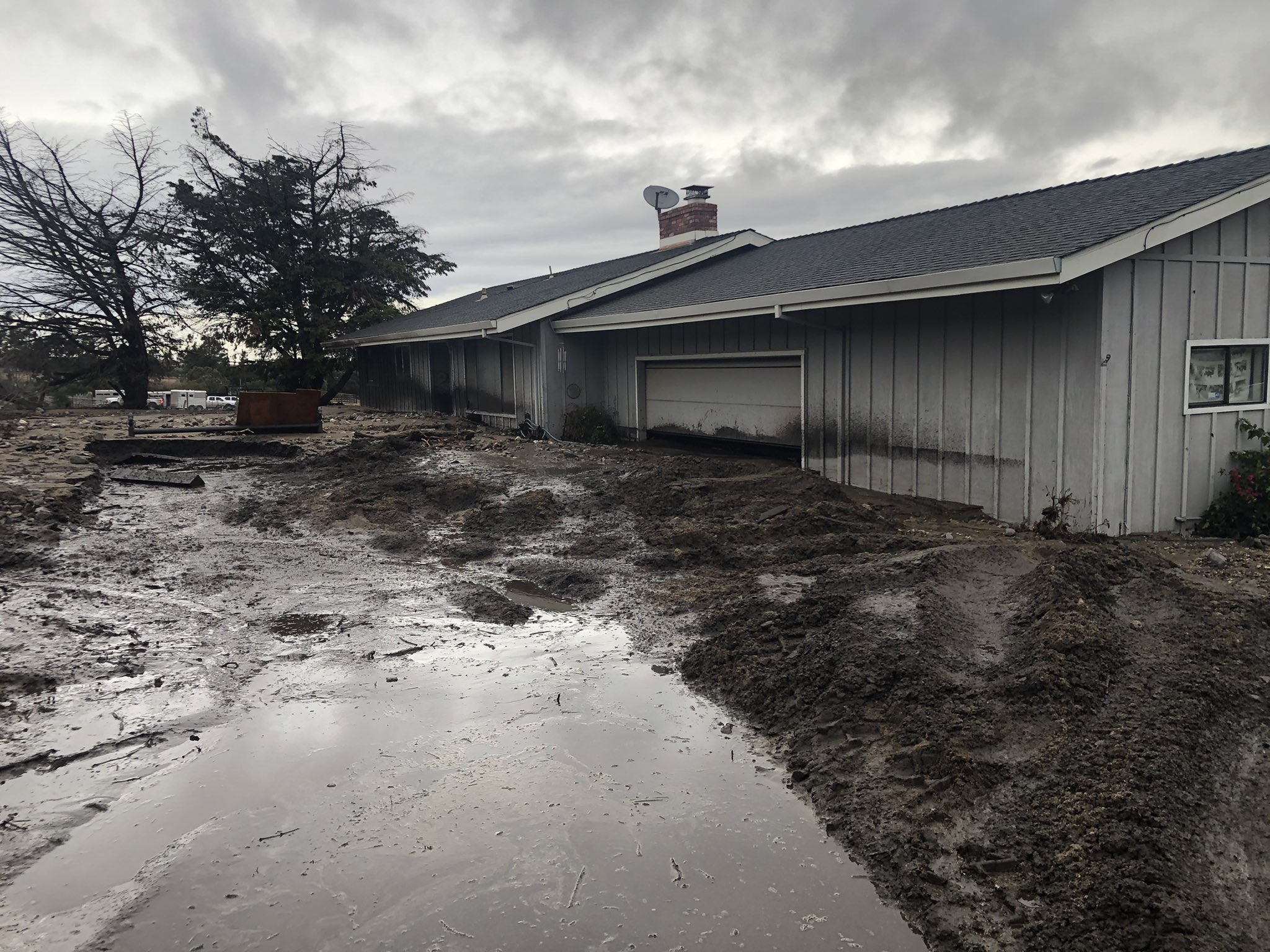
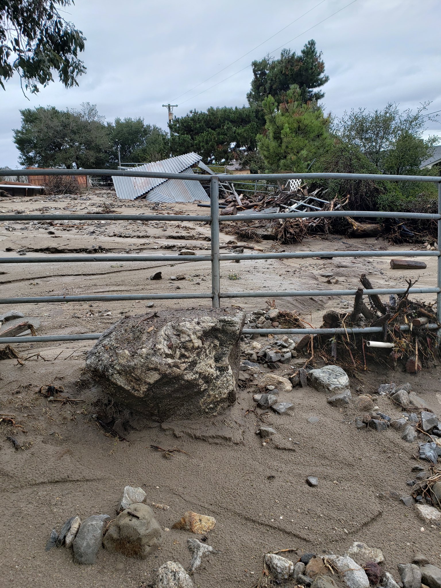
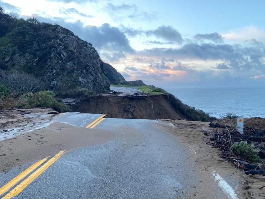
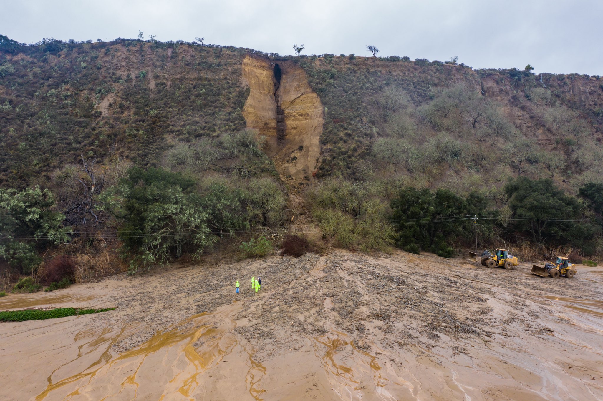
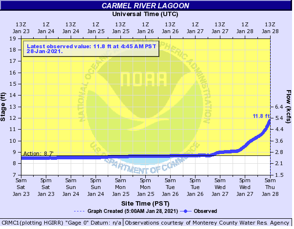
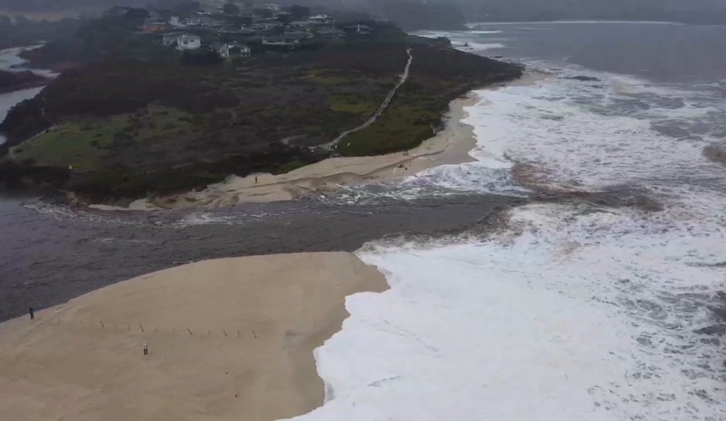
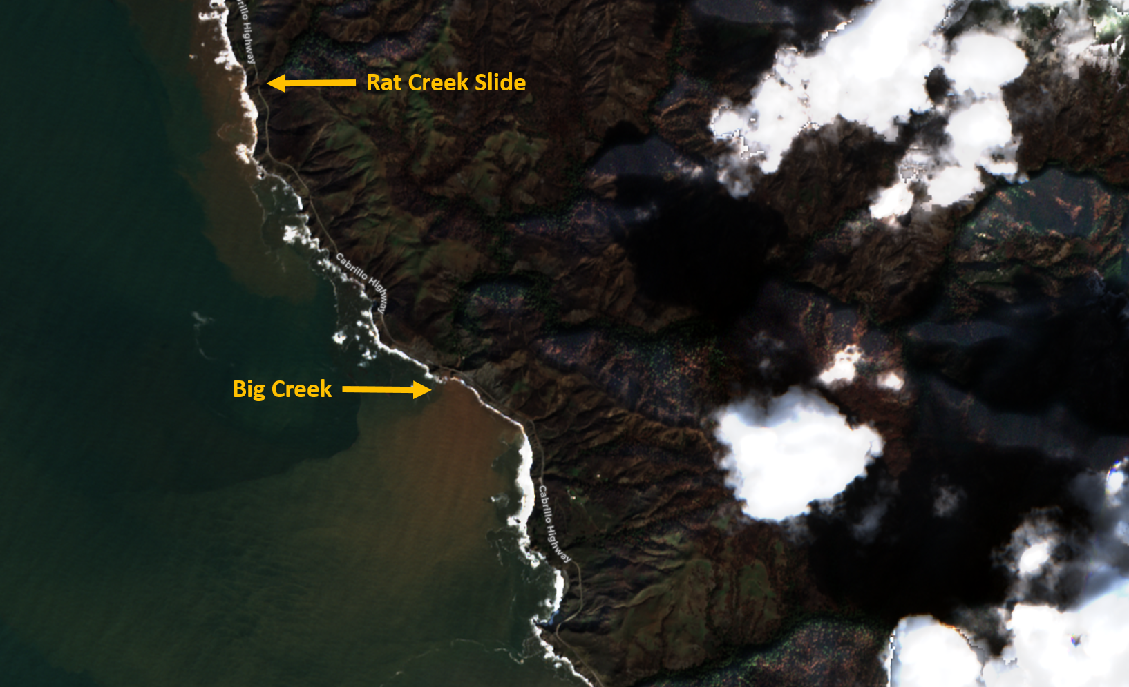
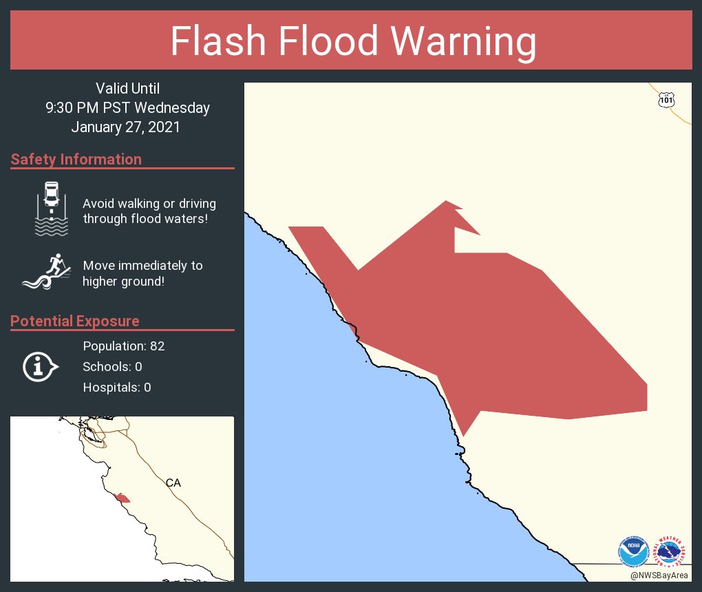
Debris/Mud Flows and Flooding
Mudflows near the River Fire burn scars covered roadways and trapped animals at local ranches. Heavy rain caused flooding near the Carmel Lagoon, which by Thursday the 28th was breached. Debris flows in Big Sur resulted in the closure of Highway 1, as mud covered pockets of roadway. By Thursday the 28th, a section of Highway 1 near Rat Creek collapsed and fell into the Pacific.
Debris Flow
 |
 |
 |
 |
|
Home impacted by mud flow along River Rd, Salina, CA Photo by @mcrfd |
Property impacted by mud flow near the River Fire burn area. Photo by NWS Employee |
Highway 1 near Rat Creek. Photo by Heath Johnston @calransD5 |
Landslide near Soledad, CA Photo by @BrianEmfinger |
Youtube Videos
Flooding
 |
 |
 |
 |
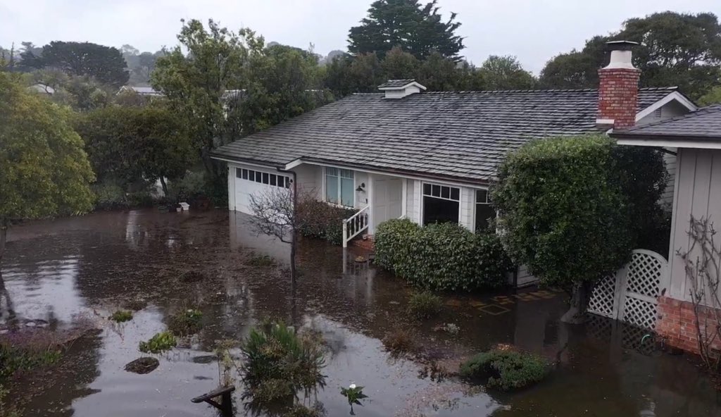
| Water coming out of the Carmel River is backing up at the Carmel Lagoon near Carmel River State Beach. A flood warning has been issued. | Carmel River flowing into the ocean. | Flooded home in Carmel by the Sea | Animation showing a before and after of Soquel Creek |
 |
 |
||
| Big Sur Coast creeks flowing into the ocean. | Flooded home in Carmel by the Sea |
Local Storm Report
National Weather Service San Francisco CA
621 AM PST Wed Jan 27 2021

..TIME...   ...EVENT...      ...CITY LOCATION...     ...LAT.LON...
..DATE...   ....MAG....      ..COUNTY LOCATION..ST.. ...SOURCE....
            ..REMARKS..

0340 PM     Debris Flow      13 SE Livermore         37.56N 121.58W
01/28/2021                   Alameda            CA   Law Enforcement

            Landslide blocking roadway on MM Mines Rd.

0100 PM     Debris Flow      4 WSW Soledad           36.41N 121.39W
01/28/2021                   Monterey           CA   Public

            Video shows debris flow damage along portion
            of River Rd at Fort Romie Rd.

0424 AM     Debris Flow      3 NE Scotts Valley      37.08N 121.98W
01/28/2021                   Santa Cruz         CA   Law Enforcement

            Mud/Dirt/Rock in 2nd LN BTWN JARVIS AND
            SUGARLOAF.

0840 PM     Debris Flow      30 ENE Soledad          36.60N 120.83W
01/27/2021                   San Benito         CA   Law Enforcement

            Mudslide on Panoche Road.

0646 PM     Debris Flow      2 N Aromas              36.90N 121.64W
01/27/2021                   Santa Cruz         CA   Law Enforcement

            Rockslide on SR-129 and Rogge Lane.

0528 PM     Debris Flow      8 SE San Jose           37.23N 121.75W
01/27/2021                   Santa Clara        CA   Law Enforcement

            Mud/dirt/rocks in roadway at Metcalf Rd and
            Monterey Hwy.

0501 PM     Debris Flow      2 NE Bolinas            37.93N 122.68W
01/27/2021                   Marin              CA   Law Enforcement

            Rockslide onto roadway at SR-1 near Bolinas.

0309 PM     Debris Flow      7 WNW Gonzales          36.56N 121.55W
01/27/2021                   Monterey           CA   Broadcast Media

            Mudslide on River Road 1/2 mile NW of
            Chualar River Rd. Photos show damage to
            nearby homes and structures.

0300 PM     Debris Flow      23 S Carmel Valley Vill 36.15N 121.67W
01/27/2021                   Monterey           CA   Public

            Video shows debris flow in Anderson Canyon
            this afternoon. Exact timing unknown,
            estimated between 2 and 4 pm.

0239 PM     Debris Flow      13 WNW Monte Rio        38.52N 123.25W
01/27/2021                   Sonoma             CA   Law Enforcement

            Mudslide on SR-1 and Fort Ross Rd.

1130 AM     Debris Flow      35 SE King City         35.80N 120.75W
01/27/2021                   Monterey           CA   Law Enforcement

            Mudslide on US-101 S and Camp Roberts,
            closure of road.

1040 AM     Debris Flow      27 SW Greenfield        36.05N 121.59W
01/27/2021                   Monterey           CA   Public

            Mudslide onto HWY 1 at mile marker 27.

1037 AM     Debris Flow      7 SSE Salinas           36.59N 121.61W
01/27/2021                   Monterey           CA   Fire Dept/Rescue

            mudslide from the River Fire burn scar.

1057 PM     Debris Flow      10 NE Yountville        38.50N 122.25W
01/26/2021                   Napa               CA   Public

            Rock slide blocking roadway near 2000 Capell
            Valley Rd.


&&

$$
|
Atmospheric River January 26-29, 2021
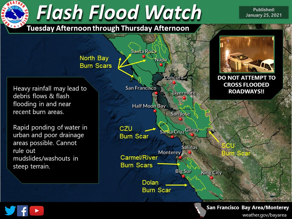
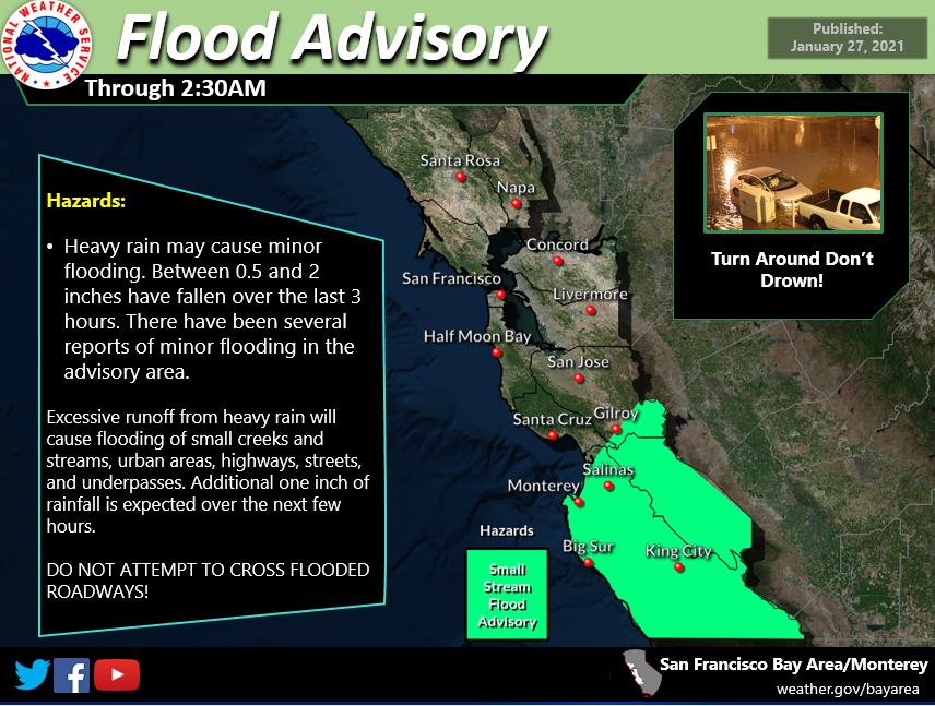
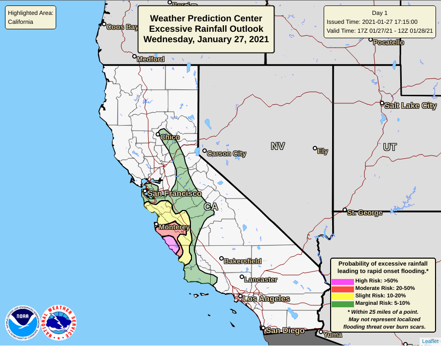
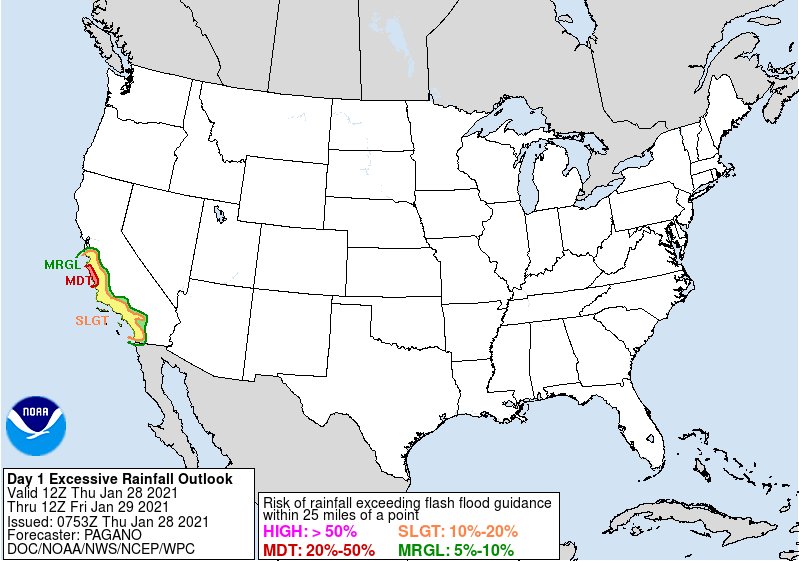
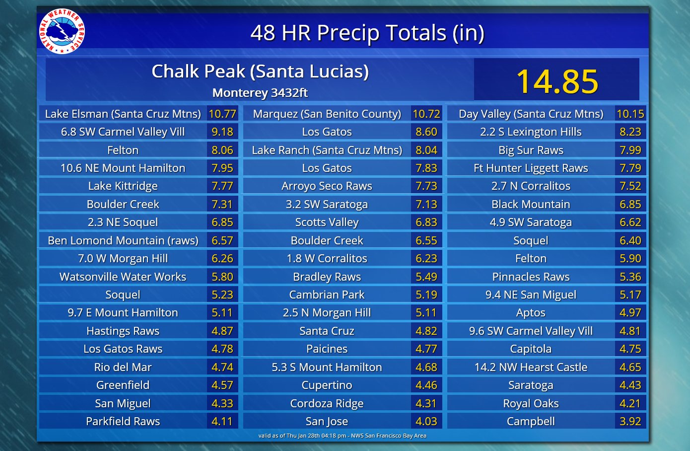
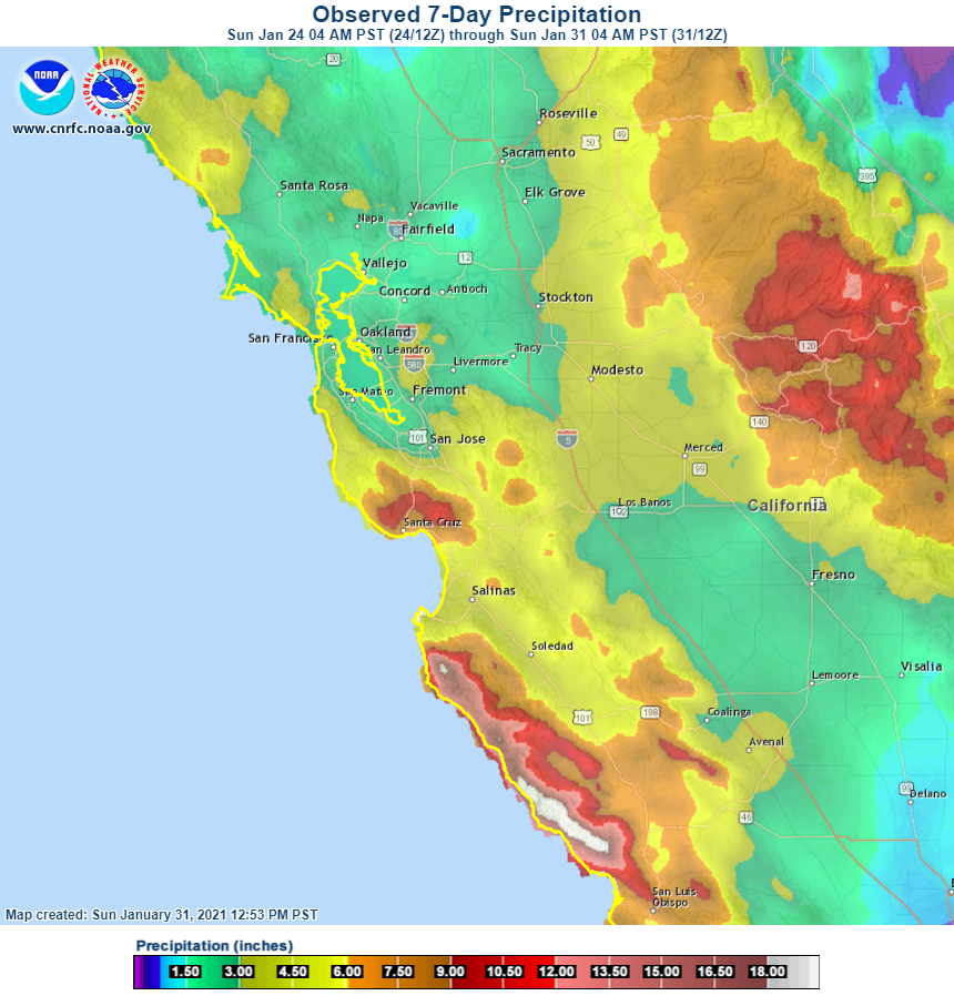
Tropical moisture from over the Pacific moved eastward and set up along the Central Coast. This this provided strong winds with reports of snow at higher elevations, a few lightning strikes, but the main impacts were from the copious amounts of heavy precipitation causing ponding and urban flooding as well as debris flows in Monterey County. Flash Flood watches were issued ahead of the event, while Flash Flood Warnings for the Walbridge, CZU Lightning Complex, River, Carmel, and Dolan burn scars were issued during the event as heavy rain rates increased. Event total precipitation totals ranged from 1.5 inches to 2.5 inches in the North Bay Valleys with the higher elevations of the North Bay Mountains received between 3 inches to 6 inches. Downtown San Francisco received 2 to 3 inches. The East Bay ranged between 2 inches to 4 inches, the South Bay 2 inches to 3 inches with the Santa Cruz mountains receiving 8 to 10 inches. By far the most rain was down the Central Coast. Monterey Valleys saw 3 to 4.5 inches with the Big Sur Coast getting between 10 and 13 inches. But it was the higher elevations of the Santa Lucia's that received between 15 inches and 20 inches.
 |
 |
 |
|
Lead Up to the AR Flash Flood Watches were issued. |
Persistent rainfall led to urban and small stream flooding. |
Flash Flood Warning issued for Dolan Fire Burn Area |
 |
 |
 |
|
WPC issued a high risk potential for flash flooding along the Central Coast Jan 27, 2021 |
WPC issued a high risk potential for flash flooding along the Central Coast Jan 28, 2021 |
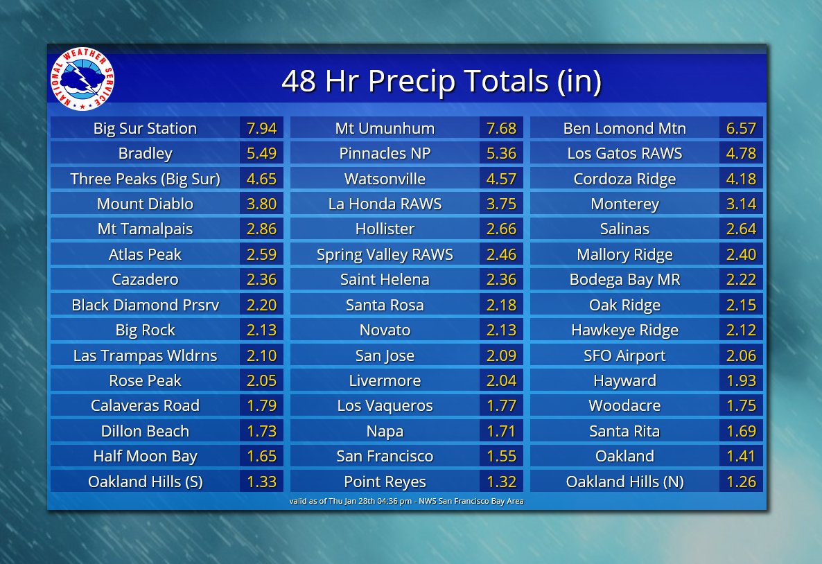
48 hour rainfall totals ending Jan 28, 2021 |
 |
 |
|
|
48 hour rainfall totals ending Jan 28, 2021 |
Estimated rainfall totals |
|
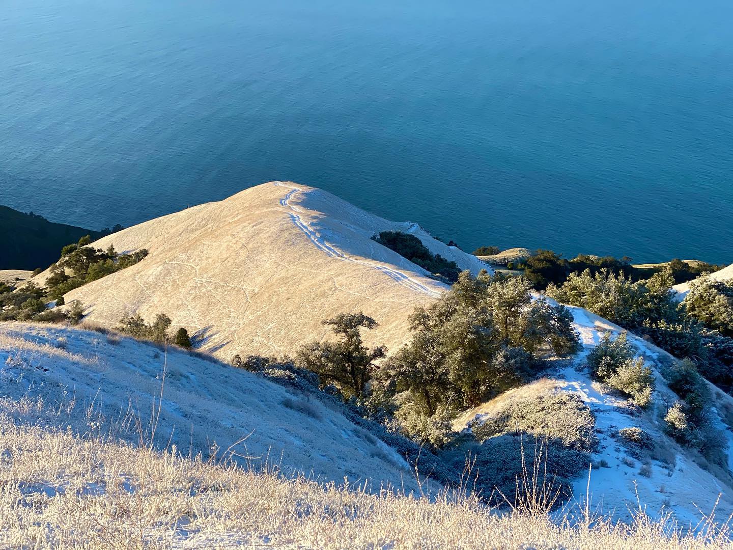
Snow
 |
 |
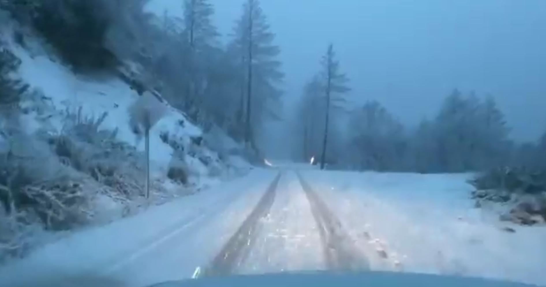 |
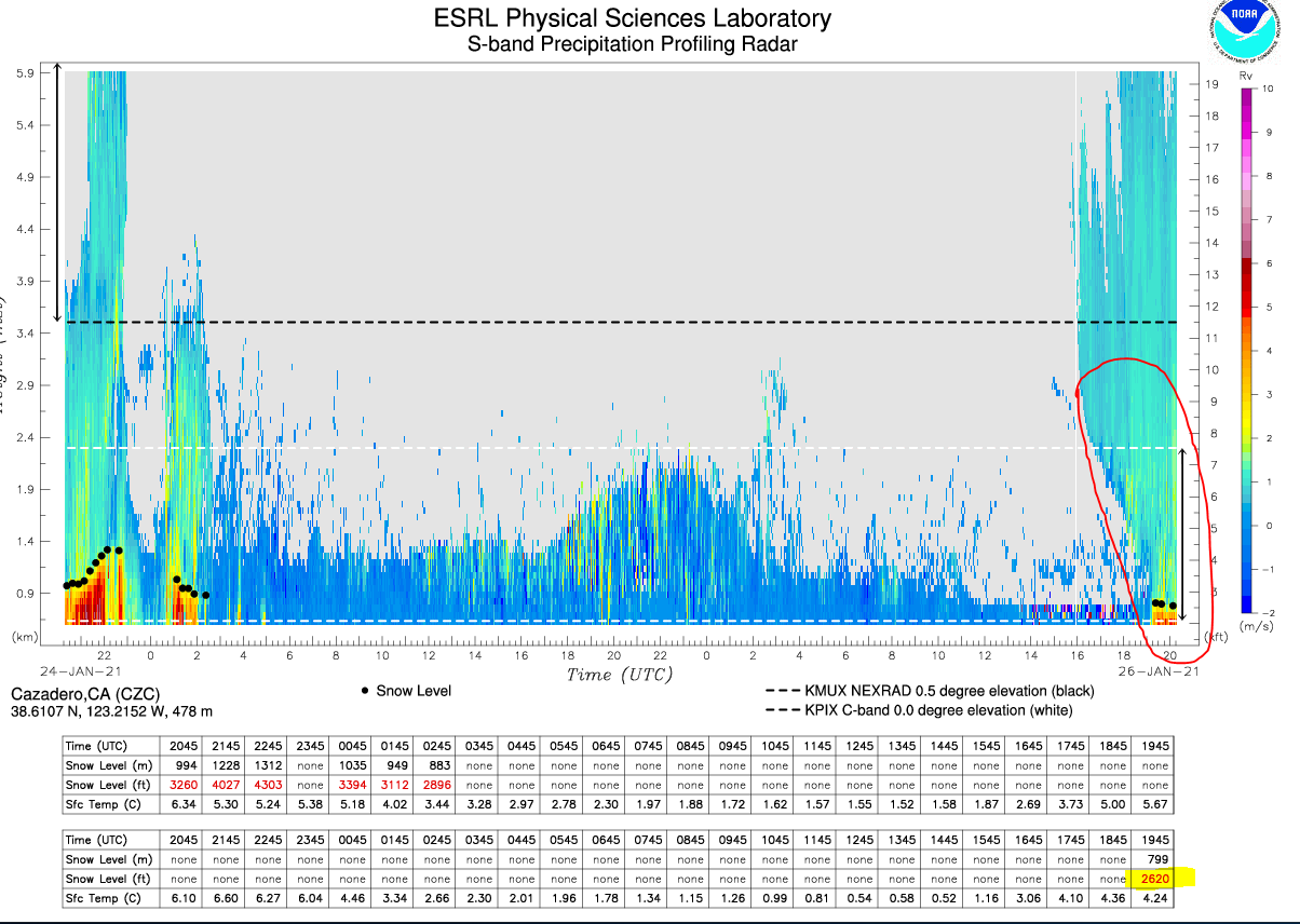
| Initial rain bands reaching northwest Sonoma county with the profiling radar near Cazadero showing the moistening of the lower atmosphere. This device measures and estimates an observed snow level of 2620 feet right now (highlighted in lower right). |
Light snow accumulations above Big Sur. Photo By L Pantilat |
1,300ft elevation on Geysers Road above the Alexander Valley, Sonoma County Tuesday evening. Photo by @kentphotos |
..TIME...   ...EVENT...      ...CITY LOCATION...     ...LAT.LON...
..DATE...   ....MAG....      ..COUNTY LOCATION..ST.. ...SOURCE....
            ..REMARKS..

0740 PM     Snow             6 W Saratoga            37.26N 122.12W
01/26/2021  E4.0 inch        Santa Cruz         CA   Law Enforcement

            Snow reported on SR 9 and SR 35, 3 to 5
            inches.
 |
Media use of NWS Web News Stories is encouraged! Please acknowledge the NWS as the source of any news information accessed from this site. |
|