Overview
|
Just one day after a derecho brought widespread wind damage to Middle Tennessee, another complex of severe thunderstorms called a MCS (Mesoscale Convective System) developed across western Tennessee in the afternoon hours on May 4 then moved across southern Middle Tennessee during the evening hours. These storms once again produced widespread straight-line wind damage across Perry, Lewis, Wayne, Lawrence, and Giles Counties, and also dropped very large hail up to lime size in parts of Wayne County. Behind these storms, an uncommon feature called a "wake low" formed on the back edge of the rain across the Nashville metro area and surrounding counties, producing strong southeast winds of 40 to 60 mph for a few hours late in the evening. These winds, although well north of the severe thunderstorms along the Alabama border, nevertheless caused additional widespread wind damage from Lewis County northeastward to Wilson County. |
|
Photos
 |
 |
 |
 |
| 2" Hail in Lutts, TN (via Tennessee River Valley News on Facebook) |
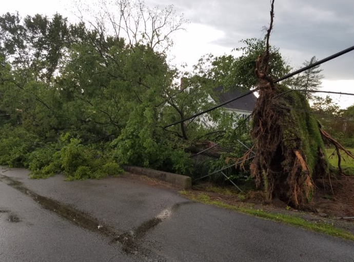
Hwy 13 in Linden, TN (via 101.3 WOPC on Facebook) |
Hassell Street in Waynesboro, TN (via Wayne County News) |
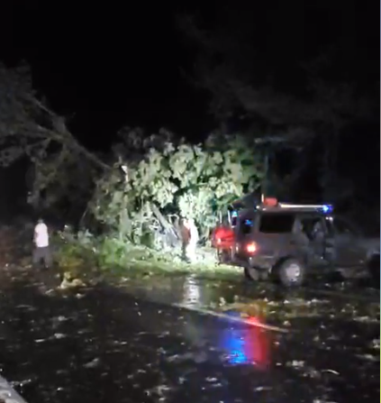
Nashville, TN (via @KatyMorganwx on Twitter) |
Radar
| OHX radar loop on May 4, 2020 |
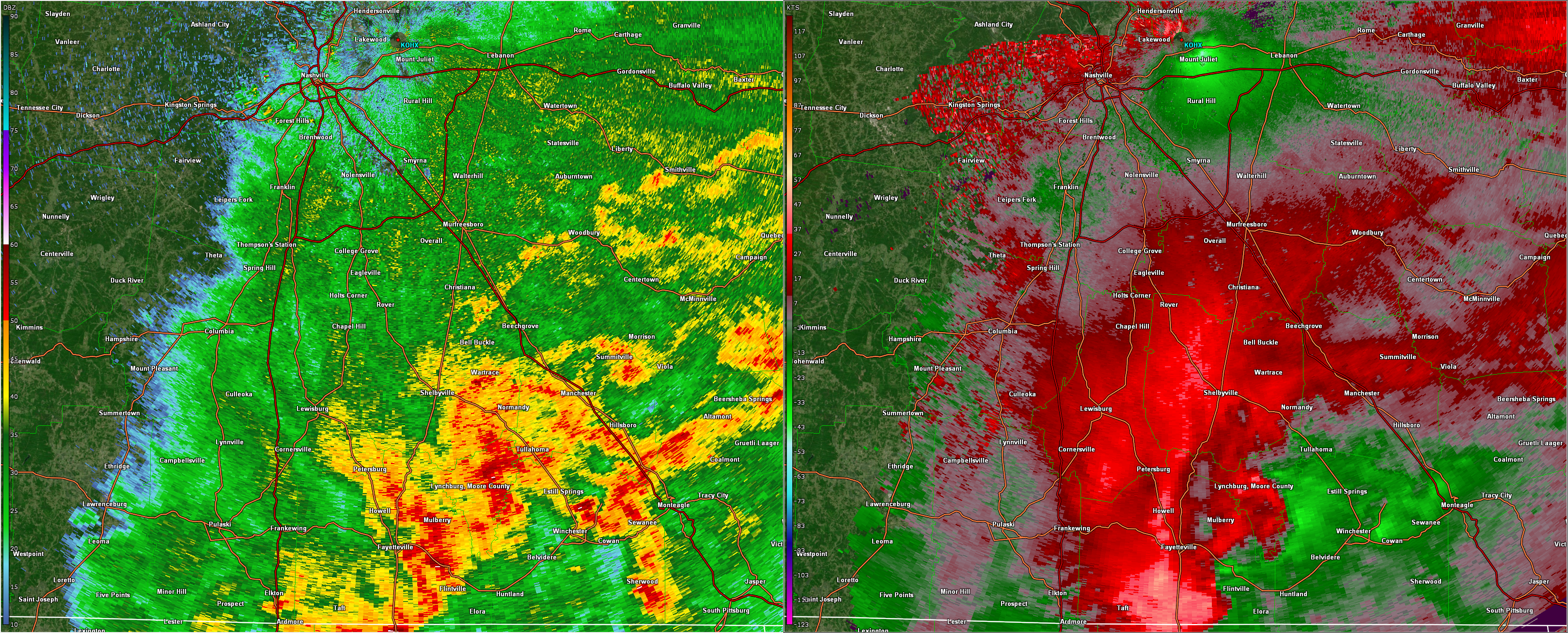 |
| OHX radar image at 934 PM CDT on May 4, 2020 showing the severe storms in southern Middle Tennessee and the wake low winds over Mount Juliet |
Storm Reports
PRELIMINARY LOCAL STORM REPORT...SUMMARY
NATIONAL WEATHER SERVICE NASHVILLE TN
1016 AM CDT THU MAY 07 2020

..TIME...   ...EVENT...      ...CITY LOCATION...     ...LAT.LON...
..DATE...   ....MAG....      ..COUNTY LOCATION..ST.. ...SOURCE....
            ..REMARKS..

0708 PM     HAIL             1 NW LINDEN             35.62N  87.86W
05/04/2020  E1.00 INCH       PERRY              TN   SOCIAL MEDIA

            HAIL UP TO QUARTER SIZE FELL ON AIRPORT RIDGE ROAD

0740 PM     HAIL             LINDEN                  35.61N  87.84W
05/04/2020  E1.00 INCH       PERRY              TN   SOCIAL MEDIA

            QUARTER SIZE HAIL REPORTED NEAR LINDEN

0757 PM     HAIL             3 NNE CLIFTON           35.42N  87.98W
05/04/2020  E2.00 INCH       WAYNE              TN   EMERGENCY MNGR

            2 INCH DIAMETER HAIL REPORTED IN BEECH CREEK AREA

0805 PM     TSTM WND DMG     7 NNE CLIFTON           35.48N  87.94W
05/04/2020                   PERRY              TN   SOCIAL MEDIA

            NUMEROUS TREES AND POWER LINES DOWN ON WHITEOAK CREEK
            ROAD

0815 PM     TSTM WND DMG     WAYNESBORO              35.32N  87.76W
05/04/2020                   WAYNE              TN   SOCIAL MEDIA

            LARGE TREE UPROOTED ON HASSELL STREET NEAR THE TOWN
            SQUARE

0820 PM     HAIL             LUTTS                   35.15N  87.94W
05/04/2020  E2.00 INCH       WAYNE              TN   SOCIAL MEDIA

            FACEBOOK PHOTO SHOWED 2 INCH HAIL FELL NEAR LUTTS

0821 PM     HAIL             LUTTS                   35.15N  87.94W
05/04/2020  E1.75 INCH       WAYNE              TN   EMERGENCY MNGR

            GOLF BALL SIZE HAIL REPORTED IN LUTTS

0829 PM     TSTM WND DMG     10 E WAYNESBORO         35.32N  87.58W
05/04/2020                   LAWRENCE           TN   EMERGENCY MNGR

            TREE DOWN DOWN ON POWER LINE AT PREBBLE HILL ROAD NEAR
            HIGHWAY 64

0834 PM     TSTM WND DMG     1 SW SUMMERTOWN         35.42N  87.33W
05/04/2020                   LAWRENCE           TN   EMERGENCY MNGR

            TREE DOWN ACROSS BUFFALO ROAD NEAR HWY 240. MANY TREES
            DOWN ACROSS NORTH AND NORTHWEST LAWRENCE COUNTY.

0835 PM     TSTM WND DMG     2 SW SUMMERTOWN         35.42N  87.33W
05/04/2020                   LAWRENCE           TN   EMERGENCY MNGR

            TREE DOWN ACROSS HWY 240 NEAR LOCKER ROAD IN SUMMERTOWN

0836 PM     TSTM WND DMG     5 WSW SUMMERTOWN        35.39N  87.39W
05/04/2020                   LAWRENCE           TN   EMERGENCY MNGR

            HIGHWAY 240 BLOCKED BY A FALLEN TREE IN HENRYVILLE

0836 PM     TSTM WND DMG     SUMMERTOWN              35.43N  87.31W
05/04/2020                   LAWRENCE           TN   EMERGENCY MNGR

            TREE DOWN BLOCKING RAILROAD BED ROAD IN SUMMERTOWN

0836 PM     TSTM WND DMG     2 NW SUMMERTOWN         35.45N  87.33W
05/04/2020                   LAWRENCE           TN   EMERGENCY MNGR

            TREE DOWN BLOCKING PART OF HIGHWAY 20

0841 PM     TSTM WND GST     3 NE LAWRENCEBURG       35.27N  87.31W
05/04/2020  E60 MPH          LAWRENCE           TN   EMERGENCY MNGR

            55 TO 60 MPH WINDS REPORTED ON MATTOXTOWN ROAD IN NORTH
            LAWRENCEBURG

0842 PM     TSTM WND DMG     1 S LAWRENCEBURG        35.23N  87.34W
05/04/2020                   LAWRENCE           TN   EMERGENCY MNGR

            POWER LINES DOWN AT VIRGINIA DRIVE AND HIGHWAY 43

0843 PM     TSTM WND DMG     1 E LAWRENCEBURG        35.25N  87.32W
05/04/2020                   LAWRENCE           TN   EMERGENCY MNGR

            TREE DOWN ACROSS SPRINGER ROAD. PEA SIZE HAIL IN WEST
            LAWRENCEBURG.

0843 PM     TSTM WND DMG     2 S LAWRENCEBURG        35.22N  87.34W
05/04/2020                   LAWRENCE           TN   EMERGENCY MNGR

            TREE DOWN ON CAR WITH PERSON TRAPPED AT 1290 CROWDER
            ROAD

0843 PM     TSTM WND DMG     3 E LAWRENCEBURG        35.25N  87.28W
05/04/2020                   LAWRENCE           TN   EMERGENCY MNGR

            TREES BLOCKING ROAD AT WEEKLY CREEK ROAD AND MILLER
            ROAD EAST OF LAWRENCEBURG

0857 PM     TSTM WND DMG     PULASKI                 35.20N  87.03W
05/04/2020                   GILES              TN   SOCIAL MEDIA

            SEVERAL POWER LINES BLOWN DOWN IN PULASKI

0905 PM     TSTM WND DMG     MINOR HILL              35.04N  87.17W
05/04/2020                   GILES              TN   SOCIAL MEDIA

            NUMEROUS TREES AND POWER LINES BLOWN DOWN ACROSS GILES
            COUNTY WITH SOME ROADS BLOCKED

0915 PM     NON-TSTM WND DMG HOHENWALD               35.55N  87.56W
05/04/2020                   LEWIS              TN   PUBLIC

            SEVERAL TREES WERE BLOWN DOWN AROUND HOHENWALD FROM
            WAKE LOW WINDS

0935 PM     NON-TSTM WND DMG FAIRVIEW                35.98N  87.12W
05/04/2020                   WILLIAMSON         TN   SOCIAL MEDIA

            WAKE LOW WINDS BLEW DOWN NUMEROUS TREES IN FAIRVIEW

0938 PM     NON-TSTM WND DMG GOODLETTSVILLE          36.32N  86.71W
05/04/2020                   DAVIDSON           TN   TRAINED SPOTTER

            TREE DOWN

0945 PM     NON-TSTM WND DMG 1 NW GREEN HILL         36.24N  86.58W
05/04/2020                   WILSON             TN   NWS EMPLOYEE

            SEVERAL TREES SNAPPED AND UPROOTED IN AN EAST TO WEST
            DIRECTION ON SAUNDERSVILLE ROAD NEAR THE NWS OFFICE

0949 PM     NON-TSTM WND DMG HENDERSONVILLE          36.29N  86.60W
05/04/2020                   SUMNER             TN   BROADCAST MEDIA

            POWER OUTAGES IN INDIAN LAKE NEIGHBORHOOD

0950 PM     NON-TSTM WND DMG NASHVILLE               36.17N  86.78W
05/04/2020                   DAVIDSON           TN   SOCIAL MEDIA

            SEVERAL TREES AND POWER LINES DOWN ACROSS NASHVILLE
            FROM WAKE LOW WINDS

0950 PM     NON-TSTM WND DMG NASHVILLE               36.17N  86.78W
05/04/2020                   DAVIDSON           TN   SOCIAL MEDIA

            LARGE LIMBS DOWN IN BELMONT WAVERLY NEIGHBORHOOD

1000 PM     NON-TSTM WND DMG MOUNT JULIET            36.21N  86.52W
05/04/2020                   WILSON             TN   SOCIAL MEDIA

            TREES AND POWER LINES REPORTED DOWN

1002 PM     NON-TSTM WND DMG 1 S FRANKLIN            35.91N  86.84W
05/04/2020                   WILLIAMSON         TN   SOCIAL MEDIA

            TRANSFORMERS BLOWN IN FRANKLIN OFF OF SUNSET AVE.

1006 PM     NON-TSTM WND DMG 2 E NASHVILLE           36.17N  86.75W
05/04/2020                   DAVIDSON           TN   SOCIAL MEDIA

            TREE LIMB THROUGH A ROOF IN EAST NASHVILLE

1007 PM     NON-TSTM WND DMG NOLENSVILLE             35.95N  86.65W
05/04/2020                   WILLIAMSON         TN   TRAINED SPOTTER

            TREES DOWN

1008 PM     NON-TSTM WND DMG BRENTWOOD               36.00N  86.79W
05/04/2020                   WILLIAMSON         TN   EMERGENCY MNGR

            TREES AND POWER LINES DOWN ON WILSON PIKE


&&

EVENT NUMBER OHX2000412 OHX2000387 OHX2000388 OHX2000409 OHX2000413
OHX2000414 OHX2000389 OHX2000393 OHX2000398 OHX2000399 OHX2000392
OHX2000394 OHX2000397 OHX2000390 OHX2000395 OHX2000391 OHX2000396
OHX2000400 OHX2000415 OHX2000416 OHX2000417 OHX2000401 OHX2000406
OHX2000418 OHX2000402 OHX2000403 OHX2000404 OHX2000407 OHX2000405
OHX2000410 OHX2000408 OHX2000411


$$

SHAMBURGER
Peak Wind Gusts
PUBLIC INFORMATION STATEMENT
NATIONAL WEATHER SERVICE NASHVILLE TN
1117 PM CDT MON MAY 4 2020

...MAY 4, 2020 PEAK WIND GUSTS THROUGH 11 PM CDT...

LOCATION                     SPEED     TIME/DATE       PROVIDER
LEWISBURG TOWER              50 MPH    0906 PM 05/04   RAWS
NASHVILLE                    48 MPH    0950 PM 05/04   CWOP
NASHVILLE                    47 MPH    0856 PM 05/04   ASOS
VANDERBILT UNIVERSITY        44 MPH    0950 PM 05/04   MESOWEST
LAWRENCEBURG                 43 MPH    0846 PM 05/04   CWOP
CLARKSVILLE                  43 MPH    0837 PM 05/04   ASOS
LEBANON                      40 MPH    0955 PM 05/04   AWOS
LAWRENCEBURG                 39 MPH    0855 PM 05/04   AWOS
COLUMBIA                     38 MPH    0935 PM 05/04   AWOS
SHELBYVILLE                  37 MPH    0915 PM 05/04   AWOS
MERIWETHER LEWIS             36 MPH    0922 PM 05/04   RAWS
3 SSW PULASKI                35 MPH    0915 PM 05/04   AWOS
MURFREESBORO                 35 MPH    1035 PM 05/04   AWOS
TULLAHOMA                    35 MPH    0955 PM 05/04   AWOS
4.3 E COLUMBIA (WEATHERSTEM) 33 MPH    1000 PM 05/04   MESOWEST
FORT CAMPBELL                32 MPH    0915 PM 05/04   RAWS
WOODBURY                     31 MPH    1101 PM 05/04   CWOP
STILLY HOLLOW                31 MPH    0826 PM 05/04   RAWS
SPRING HILL                  30 MPH    1000 PM 05/04   CWOP
CROSSVILLE                   30 MPH    1004 PM 05/04   ASOS

OBSERVATIONS ARE COLLECTED FROM A VARIETY OF SOURCES WITH VARYING
EQUIPMENT AND EXPOSURES. WE THANK ALL VOLUNTEER WEATHER OBSERVERS
FOR THEIR DEDICATION. NOT ALL DATA LISTED ARE CONSIDERED OFFICIAL.

$$

SHAMBURGER
 |
Media use of NWS Web News Stories is encouraged! Please acknowledge the NWS as the source of any news information accessed from this site. |
|


