National Weather Service United States Department of Commerce

Areas of Severe Thunderstorms and Excessive Rainfall through Memorial Day

Multiple rounds of thunderstorms are forecast to impact portions of the Southern Plains, Mid-South, and Tennessee Valley through Memorial Day. Severe thunderstorms may produce large hail, severe wind gusts, and a few tornadoes. Excessive rainfall is also likely and may result in scattered to numerous instances of flash flooding. Read More >

Modeled for the reach of river from the Wood River Trailhead near Sage Road north of Ketchum downstream to the Big Wood River Bridge on Glendale Road just south of Bellevue

In 2022, the U.S Army Corps of Engineers, in cooperation with other federal agencies, released a report updating flooding frequency and innundation mapping on the Big Wood River.

Disclaimer: These maps are provided by the U.S. Army Corp. of Engineers and hosted by the National Weather Service. See the disclaimers below.

  • These maps were created in July, 2022 by USACE using the best and latest available data at the time. It may or may not accurately reflect existing conditions.
  • These maps represent theoretical inundation from the Big Wood River based on channel conditions present in 2022. As river conditions continue to change, the area of inundation will likely also change from the limits shown.
  • These maps are meant to inform the public of potential risks. The public should communicate with their city and/or county to understand the potential impacts, responses, and methods of emergency warning communication.


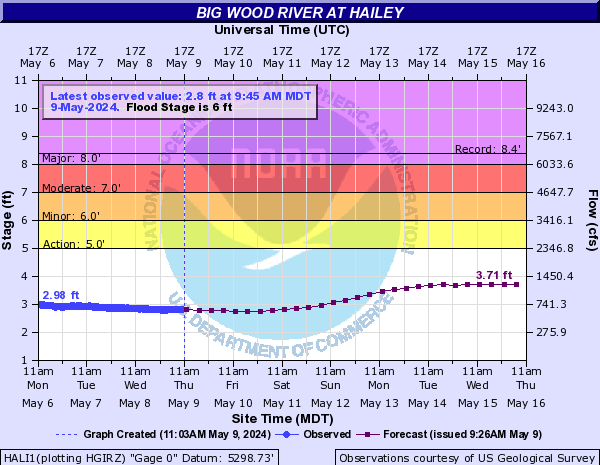
The levels of flooding in these innundation maps are modeled to particular cfs (cubic feet per second) flow rate values when measured at the Big Wood River at Hailey river gauge.

Residents of Blaine Co that have questions on how flooding may impact you, your property, or your community, please contact Blaine County Emergency Services. For information on this page or NWS forecasts, please contact our office.

Current Water Levels - Big Wood River at Hailey

Observed: cfs               Forecast: cfs


Big Wood River at Hailey

Flood Innundation Mapped As Specific Flow Rates

Select a CFS value above to view the corresponding innundation map