Active spring pattern across the center of the nation with several rounds of severe thunderstorms in the forecast through the weekend. The regions under the greatest threats are the southern Plains into the Mississippi Valley. Meanwhile, dry and breezy conditions with dry fuels are aiding in wildfires across the western High Plains and the Southeast. Wind and some snow for northern Rockies. Read More >
Effective Tuesday, July 10, 2018, at 1200 PM Mountain Standard Time, 1800 Coordinated Universal Time (UTC), the NWS WFO in Pocatello, Idaho (WFO PIH) will change all public forecast zone names and boundaries. Upon implementation of this change, all public forecasts and related products will use the zone numbers and names shown below.
The zone changes will improve services by allowing more fine-tuned warnings and advisories for hazards such as dust, fog, and winter weather.
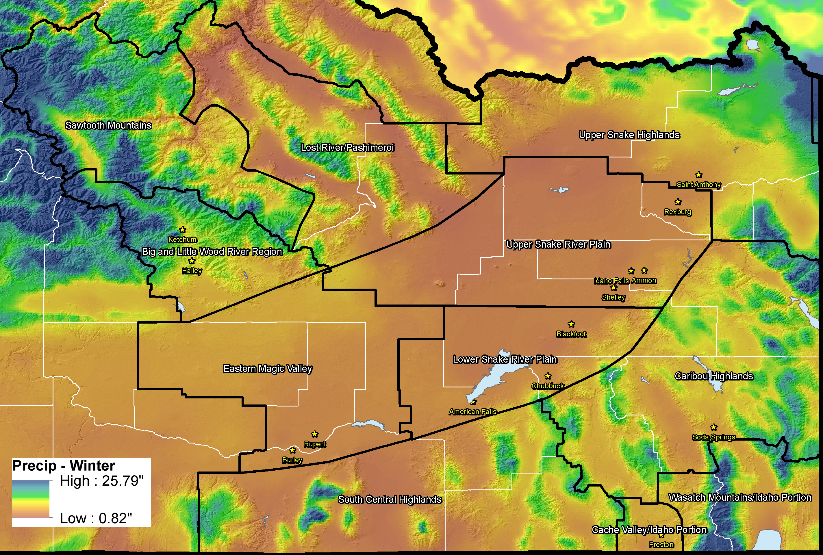
In Idaho, most long-fused watches, warnings, and advisories issued by the NWS (such as Wind Advisories and Winter Storm Warnings) are issued in areas called “zones”. Our current configuration of 11 forecast zones was created during the mid 1990s using broad-brushed climate areas and has not significantly changed since that time. Over the years, NWS Pocatello meteorologists have found that our current zone configuration does not adequately reflect important local differences in geography and weather impacts. This sometimes results in "over-warning", where an impact is occuring within the current structure of our zones.
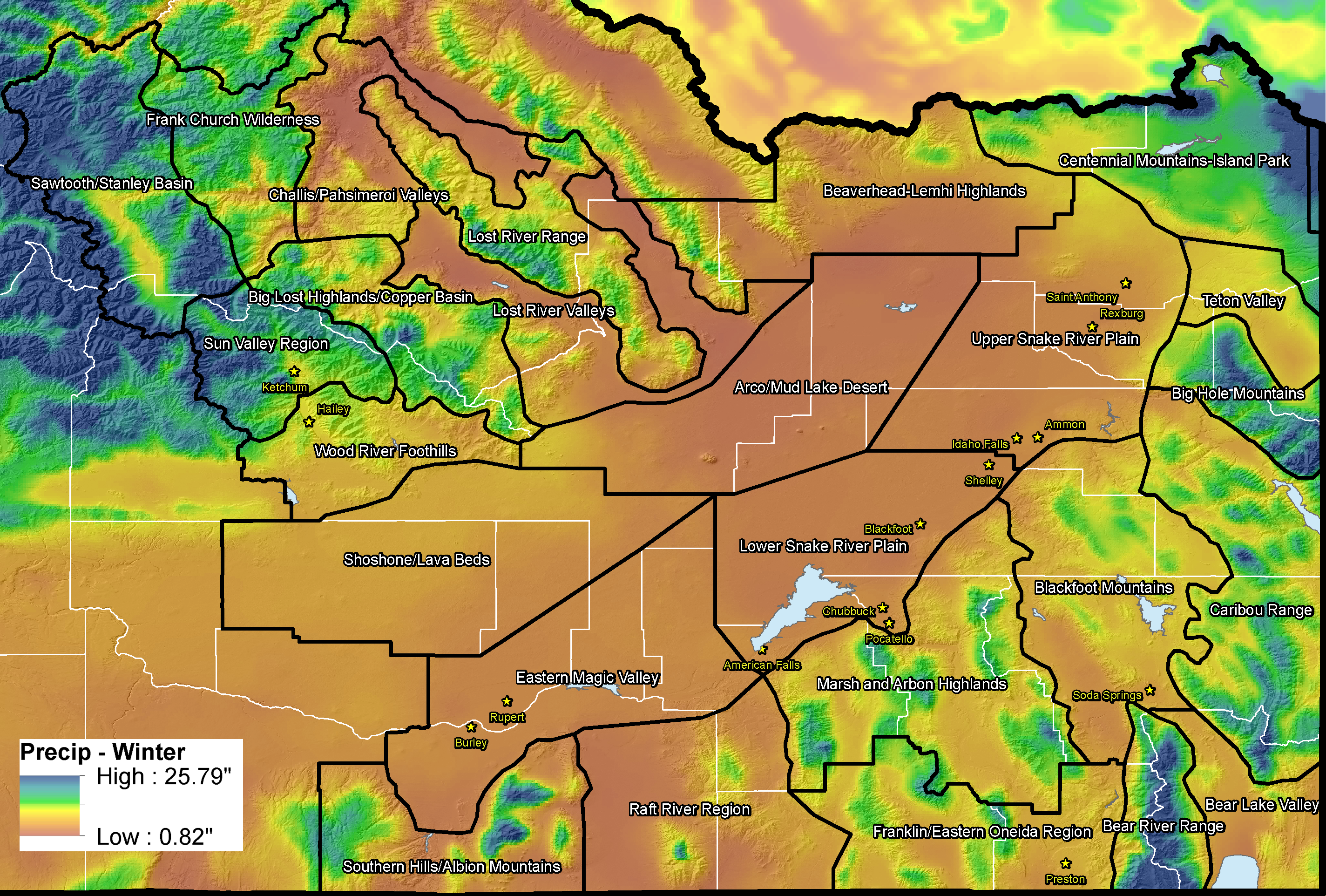
To provide a better service to our community we are working towards changing our zone configuration from 11 zones to 25 zones. These proposed zone changes are based on both climatological data, such as average annual precipitation, known weather, water and climate impacts, and forecaster experience. These changes were extensively discussed and collaborated with local and state emergency managers.
The new proposed zones will allow us to better emphasize local impact areas and provide more accurately watches, warnings, and advisories in these known regions. Recent feedback about this proposal from several local media sources and our Idaho Transportation Department partners was very positive.
There are numerous examples of how adopting a new forecast zone configuration would be valuable for both our core partners, and the public:
Example 1: High wind events sometimes target the Arco Desert region without having significant impacts in the immediate Idaho Falls and Rexburg areas. Under the current zone configuration, a High Wind Warning would include both of these areas. Under the new zone proposal, we would be able to issue a warning specifically for the Arco Desert without warning Idaho Falls and Rexburg, or we would have the option to issue an advisory instead of a warning for Idaho Falls and Rexburg to reflect lesser impacts compared to the Arco Desert.
Example 2: Significantly more snow often falls in the mountains of the Bear River Range west of Bear Lake than what is observed at lower elevations over Bear Lake and Montpelier. Under the current zone configuration, an advisory or warning would have to be issued for both Bear Lake/Montpelier and the adjacent mountains. Under the new zone proposal, we would have the option to issue a warning specifically for the Bear River Range without warning Bear Lake or Montpelier if significant accumulations are not expected there.
Current Zones |
|
|---|---|
| Zone # | Zone Name |
| IDZ017 | Eastern Magic Valley |
| IDZ018 | Sawtooth Mountains |
| IDZ019 | Upper Snake Highlands |
| IDZ020 | Upper Snake River Plain |
| IDZ021 | Lower Snake River Plain |
| IDZ022 | South Central Highlands |
| IDZ023 | Caribou Highlands |
| IDZ024 | Cache Valley-Idaho Portion |
| IDZ025 | Wastach Mountains-Idaho Portion |
| IDZ031 | Big and Little Wood River Region |
| IDZ032 | Lost River-Pahsimeroi Region |
Proposed New Zones |
|
|---|---|
| New Zone # | New Zone Name |
| IDZ051 | Shoshone/Lava Beds |
| IDZ052 | Arco/Mud Lake Desert |
| IDZ053 | Upper Snake River Plain |
| IDZ054 | Lower Snake River Plain |
| IDZ055 | Eastern Magic Valley |
| IDZ056 | Southern Hills/Albion Mountains |
| IDZ057 | Raft River Region |
| IDZ058 | Marsh and Arbon Highlands |
| IDZ059 | Franklin/Eastern Oneida Region |
| IDZ060 | Bear River Range |
| IDZ061 | Bear Lake Valley |
| IDZ062 | Blackfoot Mountains |
| IDZ063 | Caribou Range |
| IDZ064 | Big Hole Mountains |
| IDZ065 | Teton Valley |
| IDZ066 | Centennial Mountains/Island Park |
| IDZ067 | Beaverhead/Lemhi Highlands |
| IDZ068 | Lost River Valleys |
| IDZ069 | Lost River Range |
| IDZ070 | Challis/Pahsimeroi Valleys |
| IDZ071 | Frank Church Wilderness |
| IDZ072 | Sawtooth/Stanley Basin |
| IDZ073 | Sun Valley Region |
| IDZ074 | Big Lost Highlands/Copper Basin |
| IDZ075 | Wood River Foothills |
Updated public zone shapefiles are available for download via the NWS GIS Portal.
For more information or for comments, please contact us via e-mail or 208-232-9344