On this page you learn what types of flooding are typical in Vermont and how do you protect yourself, your family and your home. You will also find out more about significant Vermont floods. Finally, you'll find links to NWS offices that provide forecast and safety information for Vermont, as well as links to our partners who play a significant role in keeping you safe.
Number of fatalities: 3 (NWS Storm Data)
Number of injuries: numerous
Dollar damage: $700+ million
Significant occurrences: 3,500 homes damaged or destroyed; 500 miles of roadway and about 1,200 bridges and culverts damaged or destroyed, including 6 bridges washed away, 629 cultural sites damaged
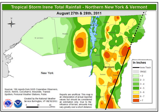
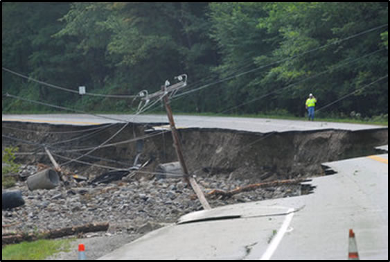
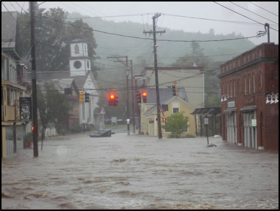
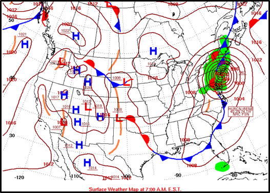
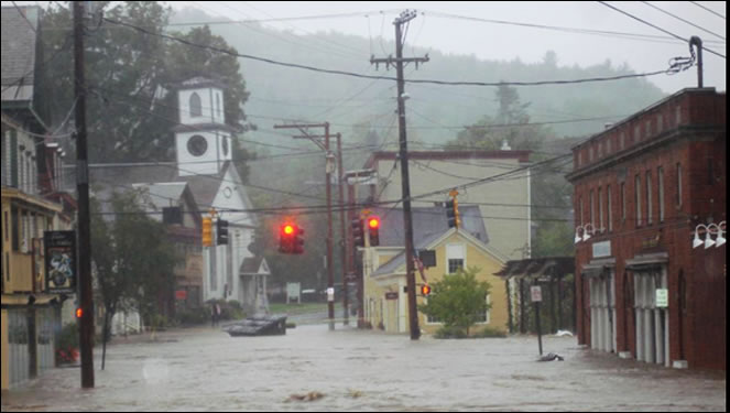
Hurricane/Tropical Storm Irene was a large West Indian tropical cyclone that moved northward across coastal New Jersey, New York, southwestern New England and eventually into the Connecticut River Valley of Vermont during August 28, 2011. While Irene’s winds were only moderately strong in Vermont, the storm produced tremendous amounts of rainfall which led to devastating flooding. As a result of the storm, 500 miles of roadway and approximately 1,200 bridges and culverts were either damaged or destroyed, 6 of which were completely washed away, including the historic Bartonsville covered bridge. In addition, 3,500 homes were damaged or destroyed, 629 cultural sites damaged, and 20,000 acres of farmland flooded. Large sections of railway were washed away along with miles of power and fiber optic cable lines, resulting in nearly 50,000 power outages across the state.
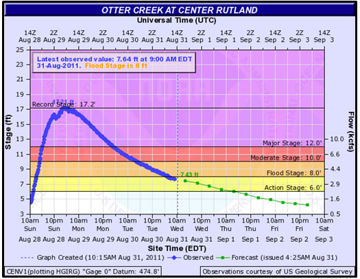
Three fatalities and numerous injuries were reported. The hardest hit areas were across central and southern Vermont, including, but not limited to the White, Mad, Dog, Winooski, Williams and West River watersheds. In these areas, moisture-laden tropical air was forced upward into the central and southern Green Mountains resulting in tremendous rainfall amounts from 4 to 8 inches in less than 18 hours. In some cases, the flooding from Irene was worse than the Great Flood of 1927, with all-time record crests observed on the Walloomsac River at North Bennington, VT and the Otter Creek at Center Rutland, VT. Overall, Irene caused over $700 million in damages to state infrastructure and private property. As a result of its devastating impact on the state, Tropical Storm Irene ranks as the second greatest natural disaster in Vermont’s history.
|
|
|
|
|
|
|
|
|
|
Learn More:
Date and locations impacted: much of western New England, including Vermont
Number of fatalities: unknown, several individual deaths documented, others sources state “many”
Number of injuries: unknown, several sources state “numerous”
Dollar damage: unknown
Significant occurrences: many bridges lost, or rebuilt in new locations as rivers/streams changed course
This was the benchmark storm for much of western New England before the turn of 20th century. Typical of this period, evidence is sketchy and anecdotal. Several contemporary references in 1927 refer to ‘27 flood as the worst since 1869, and many bridges that were reported destroyed in the 1927 event were originally built or rebuilt after the 1869 storm. The Bartonsville Bridge in the town of Rockingham, VT, was one such structure. Before the historic flooding and record high levels observed on Lake Champlain during May of 2011, the prior record high lake level was set in May of 1869, indicating the year was a wet one and prone to an elevated risk of flooding.
The event unfolded during 2 days in early October as a strong north to south oriented cold front stalled across the region while a strong hurricane known as Saxby’s Gale passed through the shipping lanes south and east of Long Island and Nantucket. Tremendous amounts of moisture were drawn northward along the stalled front, producing copious 2-day totals from 3 to 7 inches across most of the state. The Vermont Weather Book states that the average precipitation for the nine reporting stations in the state was 4.35 inches. “The greatest catches came at Castleton with 6.57 inches and Woodstock with 6.35 inches”. Burlington received 3.71 inches from the storm. Undoubtedly the higher terrain of the Green Mountains received considerably more.
While limited, documented sources suggest the most severe flooding occurred across the eastern half of the state from Brattleboro northward to Saint Johnsbury. Below are partial accounts from this great event, taken from David Ludlum’s Vermont Weather Book and other sources.
Damage in the South at Rockingham, VT:
The damage done to the town was almost beyond compute. At Bartonsville the Williams River overflowed its banks and made a short cut across a bow, sweeping away the highway, portions of the railroad track, the depot and several dwellings. Bridges were lifted from their foundations and swept down the stream……It was one of the most remarkable floods of the present century. A large number of lives were lost. (Abby Maria Hemenway, The Vermont Historical Magazine, 5, 498-99)
Damage in Springfield, VT:
In the summer of 1869 a sudden rise of Black River, caused by a shower, carried out the bulkhead of the dam just built by the Novelty Works Company, and the north end of the new stone building, not yet occupied. The great freshet, in the autumn of 1869, carried out the dam and stone buildings next to the river, just built by Ellis, Britton & Eaton. The grist mill of Henry Safford was swept away, and the residence of Joseph Smart. Mike Tully’s house (the first frame house built in the village) went off, and several houses below the lower bridge were undermined and turned upon their sides. The new iron bridge across the falls went off, with a man named Morsey, who was drowned; and every other bridge across the river except the covered bridge at the lower end of Main Street, and the Nathan White Bridge was swept away. History of the Town of Springfield, Vermont, 1895, page 160.
Damage in the North at St. Johnsbury:
Flood of 1869. A storm of thirty hour’s duration, October 2 and 3, proved the most disastrous ever known in the town. Passumpsic River at the Center Village was two and a half feet higher than any former record; streets and houses were flooded; railroad tracks were washed away; trains were stopped; for five days there was no mail from the south;
On Sleepers River the turbid waters were floating timbers, trees, logs, wagons, horse powers and endless other miscellany; soon the cry was heard: “the bridge is coming!” and like a duck on the water, came sailing down the lumber yard bridge; it broke thro (sic) the highway bridge, pitched over the dam, took out the next bridge with a crash and hurried on; for a time it was held at the foundry bridge till a broadside of the castings’ shop struck it and all went down the stream. (Edward T. Fairbanks, The Town of St. Johnsbury, VT, 519)
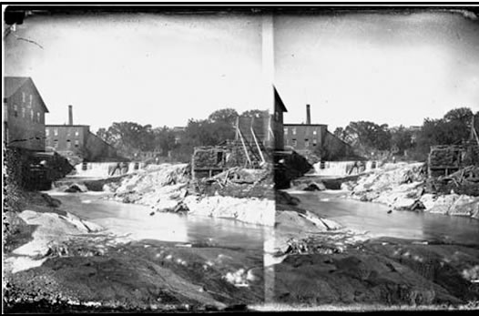
A stereo plate view shows damage in Brattleboro, VT after the Great Flood of 1869, courtesy Brattleboro Historical Society
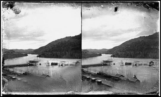
Stereo plate view of flooding and bridge damage along the Connecticut River near Brattleboro, VT train station (October 1869), courtesy Brattleboro Historical Society

Flooding along the Connecticut River in Brattleboro, VT dismantles the Hinsdale Bridge (Oct. 1869), courtesy Brattleboro Historical Society
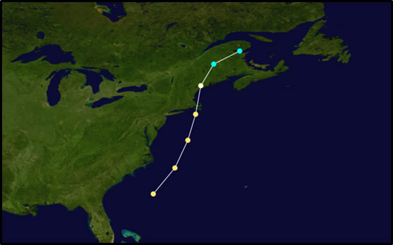
Approximate track of Saxby’s Gale, October 3-5, 1869
Number of fatalities: 5
Number of injuries: unknown
Dollar damage: $30 million (about $482 million in 2012 dollars)
Significant occurrences: Over 2,000 miles of public roads damaged or destroyed; stages higher on a few gages in the south than in the 1927 flood
The strongest hurricane to affect New England over the past 100 years struck Long Island, NY, southern New England and Vermont on September 21, 1938. It was known as the Long Island Express, taking the name from the storm’s rapid northward speed from the tropical Atlantic Ocean, by some estimates as high as 60 mph. It is only the second storm to ever maintain true hurricane status into Vermont, the other being the Hurricane of 1788. The 1938 event is best known in Vermont for its devastating winds, which in some cases destroyed up to 30 percent of the timber in eastern portions of the state. Flooding effects were also very severe, especially in the central and southern counties of the state where, in some, cases the effects were more severe than in the Great Flood of 1927.
Rainfall amounts associated directly with the hurricane were high, but not as excessive as in 1927 or with Tropical Storm Irene. In general, totals ranged from 2 to 5 inches with the highest totals in the southern portions of the state. What allowed this heavy rainfall to cause extreme flooding was a prolonged wet pattern across the state during the preceding week as moist tropical air and numerous showers streamed northward in advance of a stalled cold front across the region. The 5-day rainfall totals through the 21st were quite impressive: Brattleboro’s 8.22 inches, Somerset’s 8.20 inches. Newport in the northern portions of the state tallied only 1.87 inches, while more typical amounts were in observed at Burlington, 4.85 inches, and Northfield, 4.59 inches.
Towns such as Brattleboro, Wilmington, West Dover, Londonderry and Jamaica were all affected severely. The damage in Jamaica eclipsed that of the Great Flood of 1927 with all but two bridges on the road from Pike’s Falls to Jamaica washed away in addition to a steel bridge on Depot Street and Leon Cheney’s mill. Several small dams also failed in the area. In Londonderry, all but 6 families were evacuated, many being rescued in canoes at night. In summary, while the magnitude of flooding from the Hurricane of 1938 did not approach the devastation experienced in 1927 or during Tropical Storm Irene, it nonetheless stands the test of time as one of the most noteworthy flooding episodes in Vermont during the past 150 years, and as such ranks as the 4th most severe flooding event in the state’s history.

The raging Connecticut River at Brattleboro, VT. Figure 15. Courtesy Brattleboro Historical Society
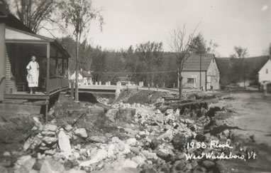
Flood damage from the 1938 Hurricane in West Wardsboro, VT, Figure 16. Source unknown, vintage postcard
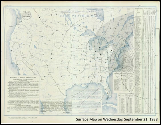
Weather Bureau surface weather map on Wednesday morning, September 21, 1938
Learn More:
Number of fatalities: 2
Number of injuries: unknown
Dollar damage: $64 million (~ $326 million adjusted for inflation 2012)
Significant occurrences: $10 million damage to Vermont state roads; record/near record floods in several southern Vermont watersheds
The flood of June 28-30, 1973, was quite severe and likely the worst in the 73-year period between the Great Flood of 1927 and Tropical Storm Irene in 2011 for several locations. The flooding was primarily caused by copious moisture streaming northward along a stalled frontal boundary across eastern New York State. Repeated rounds of heavy rainfall pushed many streams and rivers into flood. Â Many of these rivers and streams were already running high from above average monthly rainfall during May and the first half of June. Several watersheds saw record, or near-record high crests, including the Black, Ottauquechee, White and Ompompanoosac Rivers. Rainfall observations from the event included 7.50 inches at Jamaica, 7.19 inches at South Londonderry, 6.37 inches at Rochester, and 6.30 inches at Woodstock.
Total damage from the event reached an estimated $64 million, with damage to state highways around $10 million. The General Electric Company plant in Ludlow was destroyed, and innumerable crop losses resulted across the state. As a result the state was declared a federal disaster area by then President Richard Nixon.

Along Vermont Route 4, Courtesy The Vermont Standard

Leonard’s Gas and Electric Shop in Ludlow, VT, Courtesy the Vermont Standard
Learn More:
Flash flooding is a rapid and extreme flow of high water into a normally dry area, or a rapid water level rise in a stream or creek above a predetermined flood level, beginning within six hours of the causative event (i.e., intense rainfall, dam failure, ice jam). More information...
River flooding occurs when river levels rise and overflow their banks or the edges of their main channel and inundate areas that are normally dry. More information...
At any time of year, a storm from over the ocean can bring heavy precipitation to the U.S. coasts. Whether such a storm is tropical or not, prolonged periods of heavy precipitation can cause flooding in coastal areas, as well as further inland as the storm moves on shore. More information...
A back-up of water into surrounding areas can occur when a river or stream is blocked by a build-up of ice or other debris. Debris Jam: A back-up of water into surrounding areas can occur when a river or stream is blocked by a build-up of debris. More information...
Flooding due to snowmelt most often occurs in the spring when rapidly warming temperatures quickly melt the snow. The water runs off the already saturated ground into nearby streams and rivers, causing them to rapidly rise and, in some cases, overflow their banks.More information...
A break or failure can occur with little to no warning. Most often they are caused by water overtopping the structure, excessive seepage through the surrounding ground, or a structural failure. More information...
|
||||||