Overview
Severe thunderstorms brought damaging wind, large hail, and five tornadoes to the Missouri Ozarks from the evening of April 1st to the early morning hours of April 2nd. A tornado that occurred near Fair Grove was rated in EF-1. The four other tornadoes were rated EF-0 with three of them occurring from eastern Dallas County into Laclede County. The fourth EF-0 tornado occurred in St. James.
In addition to the tornadoes, storm surveys revealed several different swaths of damaging straight line wind speeds of 70-100 mph. Wind speeds of 90-100 mph caused roof damage to businesses in downtown Carthage with power poles and trees also snapped. Other swaths of significant wind damage occurred near Halltown, Elkland, and along the I-44 corridor from Waynesville to Rolla.
Several thunderstorms also produced hail from the size of quarters to tennis balls. Hail ranging from one to two inches in diameter occurred in an around Bolivar. Tennis ball size hail fell in the town of Maple Grove.
Here is an interactive website to plot severe weather reports from across the region.
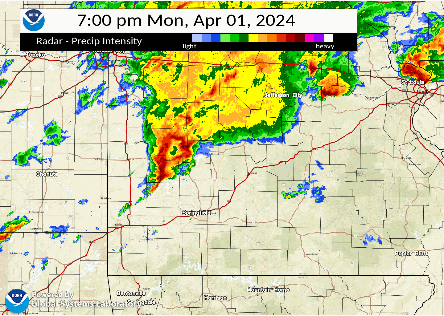
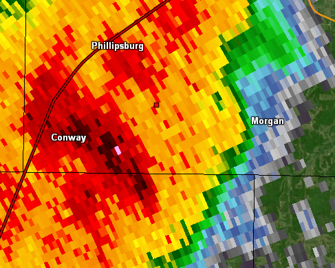
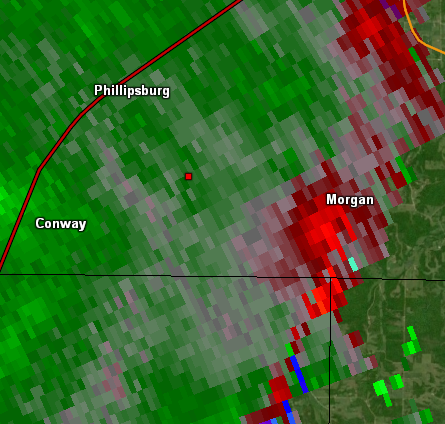
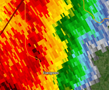
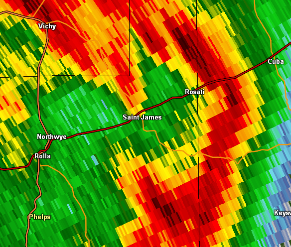
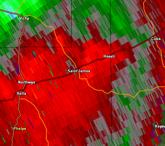
Radar Loop valid from 7 PM on April 1st to 1 AM on April 2nd
Tornadoes:
|
Tornado - Fair Grove, Missouri
Track Map

|
||||||||||||||||||||||||
|
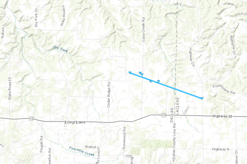
Tornado - Long Lane, Missouri
Track Map
|
|||||||||||||||||||||||||
|
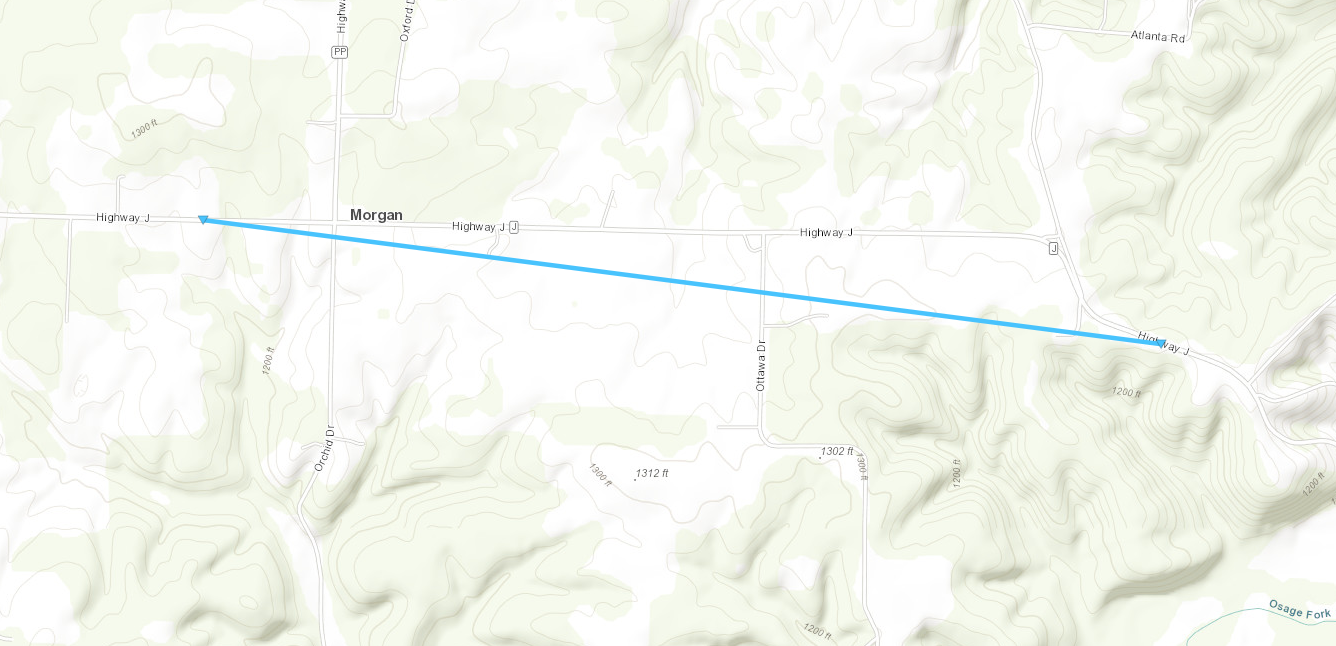
Tornado - Morgan, Missouri
Track Map
|
|||||||||||||||||||||||||
|
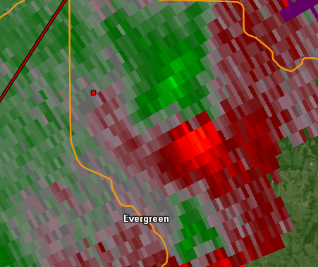
Tornado - Evergreen, Missouri
Track Map
|
||||||||||||||||||||||
|
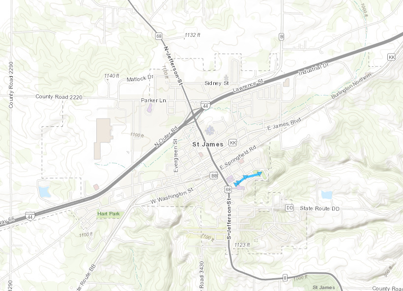
Tornado - St. James, Missouri
Track Map
|
||||||||||||||||||||||
The Enhanced Fujita (EF) Scale classifies tornadoes into the following categories:
| EF0 Weak 65-85 mph |
EF1 Moderate 86-110 mph |
EF2 Significant 111-135 mph |
EF3 Severe 136-165 mph |
EF4 Extreme 166-200 mph |
EF5 Catastrophic 200+ mph |
 |
|||||
Wind & Hail:
Here is an interactive website to plot severe weather reports from across the region.
Wind Damage
 |
 |
 |
 |
| Damage to power poles in downtown Carthage. | Damage to a building in downtown Carthage. | Damage to outbuilding near Halltown. | Uprooted tree in Waynesville. |
Hail
 |
 |
 |
 |
| Large hail in Bolivar. | Large hail in Bolivar. | Large hail in Buffalo. | Large hail in Olean. |
Storm Reports
Preliminary Local Storm Report...Summary
National Weather Service Springfield MO
408 PM CDT Thu Apr 4 2024
..TIME... ...EVENT... ...CITY LOCATION... ...LAT.LON...
..DATE... ....MAG.... ..COUNTY LOCATION..ST.. ...SOURCE....
..REMARKS..
0526 PM Hail 1 ENE Barnett 38.38N 92.66W
04/01/2024 M1.00 Inch Morgan MO Public
Reported via EM on NWSChat2.0 with photo.
0538 PM Hail Olean 38.41N 92.53W
04/01/2024 E1.75 Inch Miller MO Emergency Mngr
Photo sent in with reports from EM and 911,
estimated 1.75 hail from NWSChat2.0.
0602 PM Tstm Wnd Dmg 3 E Pittsburg 37.41N 94.65W
04/01/2024 Crawford KS Public
Social media report of a downed metal flag
pole due to thunderstorm winds.
0648 PM Hail 1 WNW Cedarville 37.58N 93.99W
04/01/2024 M1.00 Inch Dade MO CO-OP Observer
Strong winds came through for 3-5 minutes
and took over a 12 to 14 inch tree.
0654 PM Tstm Wnd Dmg 3 S Wagoner 37.62N 93.92W
04/01/2024 Cedar MO Public
Via social media picture on X. Large tree
down over the road.
0700 PM Tstm Wnd Dmg 3 W Umber View Heights 37.62N 93.85W
04/01/2024 Cedar MO Public
Report from mPING 1-inch tree limbs broken;
Shingles blown off.
0702 PM Tstm Wnd Dmg 4 E Stockton 37.70N 93.73W
04/01/2024 Cedar MO Emergency Mngr
Several three inch tree limbs down on
Highway M east of Stockton.
0707 PM Tstm Wnd Dmg 3 NE Bearcreek 37.70N 93.64W
04/01/2024 Cedar MO Public
Delayed report. Forty-foot conex container
fully flipped over fence into next field, 2
barn roofs partial missing grain bin on
side, lots of tree limbs and uprooted trees.
Time based on radar estimate.
0718 PM Tstm Wnd Dmg 3 W Bolivar 37.62N 93.47W
04/01/2024 Polk MO Amateur Radio
Had a report of some sections of vinyl
siding on a shop damaged near south 90 and
east 438 in bolivar.
0720 PM Hail Bolivar 37.62N 93.41W
04/01/2024 M1.25 Inch Polk MO Public
Photo of half dollar sized hail forwarded by
media via email. Time estimated by radar.
0720 PM Hail 4 ESE Fair Play 37.62N 93.50W
04/01/2024 M1.00 Inch Polk MO Amateur Radio
Quarter size hail and 60 mile wind between
fair play and bolivar per Polk EMD.
0720 PM Hail Bolivar 37.61N 93.41W
04/01/2024 E1.25 Inch Polk MO Public
0724 PM Hail 2 W Bolivar 37.61N 93.45W
04/01/2024 E1.00 Inch Polk MO Amateur Radio
Quarter size hail at 13 and 32 Bolivar.
0725 PM Hail Bolivar 37.62N 93.41W
04/01/2024 M2.00 Inch Polk MO Public
Photo of 2 inch hail forwarded by media via
email. Time estimated by radar.
0727 PM Hail 2 WNW Bolivar 37.63N 93.44W
04/01/2024 M1.75 Inch Polk MO Emergency Mngr
Golf ball sized hail reported by
Polk EMD via HAM SKYWARN on NWSChat2.0.
0727 PM Hail 2 NNE Bolivar 37.64N 93.40W
04/01/2024 E2.00 Inch Polk MO Fire Dept/Rescue
Estimated egg size hail.
0730 PM Hail 2 NE Bolivar 37.63N 93.38W
04/01/2024 E1.50 Inch Polk MO Public
Report from mPING Ping Pong Ball 1.50 in.
0730 PM Hail 1 ENE Bolivar 37.62N 93.40W
04/01/2024 M1.75 Inch Polk MO Public
Photo report via email forwarded by
media.
0732 PM Hail 2 NE Bolivar 37.63N 93.38W
04/01/2024 E1.50 Inch Polk MO Public
Photo report near Bolivar, forwarded
by media via contact email. Time
estimated by radar.
0740 PM Hail 3 W Louisburg 37.76N 93.19W
04/01/2024 M1.75 Inch Polk MO Amateur Radio
0748 PM Tstm Wnd Dmg 1 N Buffalo 37.66N 93.09W
04/01/2024 Dallas MO Public
Report from mPING trees uprooted or snapped
and roof blown off.
0748 PM Tstm Wnd Dmg 1 N Buffalo 37.66N 93.09W
04/01/2024 Dallas MO Emergency Mngr
12 inch tree down over power lines.
0748 PM Hail 1 S Pumpkin Center 37.73N 93.07W
04/01/2024 M1.75 Inch Dallas MO Law Enforcement
Video sent from LE of golf ball size hail.
0750 PM Tstm Wnd Dmg 2 N Buffalo 37.68N 93.09W
04/01/2024 Dallas MO Public
Large tree uprooted, report via Facebook
photo. Location Airport Rd, 73 Hwy and DD
Hwy 2.2 miles N of Buffalo. Small area of
single limb with tree debarked. Time
estimated by radar.
0809 PM Hail 3 NE Barnett 38.41N 92.64W
04/01/2024 M1.00 Inch Morgan MO Public
Facebook photo report.
0852 PM Flash Flood 5 SE Versailles 38.38N 92.78W
04/01/2024 Morgan MO Public
Morgan County 911 advised MO highway patrol
that Highway W near Hollow Drive is flooded
and not passable.
0900 PM Flash Flood 1 W Barnett 38.38N 92.69W
04/01/2024 Morgan MO Law Enforcement
Area of Hill Point at Quarry Road there is a
bridge that has been washed out by flooding.
0926 PM Tstm Wnd Dmg 1 N Baxter Springs 37.05N 94.74W
04/01/2024 Cherokee KS Fire Dept/Rescue
Trees down on 50th street just north of
Baxter Springs.
0927 PM Tstm Wnd Gst 1 NE Airport Drive 37.15N 94.50W
04/01/2024 M67 MPH Jasper MO ASOS
ASOS station KJLN Joplin ASOS.
0929 PM Tstm Wnd Gst 1 NE Airport Drive 37.15N 94.50W
04/01/2024 M72 MPH Jasper MO ASOS
ASOS station KJLN Joplin ASOS.
0933 PM Tstm Wnd Dmg Brooklyn Heights 37.17N 94.38W
04/01/2024 Jasper MO Public
Photo via Facebook of large tree down in
front yard and small tree damage down in
back yard. Time estimated via radar.
0935 PM Tstm Wnd Dmg 2 ENE Brooklyn Heights 37.18N 94.36W
04/01/2024 Jasper MO Public
Facebook photo report for large tree fully
uprooted near 96 hwy and 249.
0936 PM Tstm Wnd Dmg Carthage 37.18N 94.31W
04/01/2024 Jasper MO NWS Storm Survey
NWS storm survey found straight line winds
causing roof damage to businesses in
downtown Carthage. Power poles were also
broken. Trees were snapped. Peak winds were
estimated to be 100 mph.
0938 PM Tstm Wnd Dmg Carthage 37.17N 94.31W
04/01/2024 Jasper MO Law Enforcement
REPORTED BY CARTAHGE POLICE PD CARTHAGE
SQUARE HAS BEEN DAMAGED, BROKEN WINDOWS,
POWER POLES AND LINES DOWN. Time based on
radar.
0939 PM Tstm Wnd Dmg Airport Drive 37.14N 94.51W
04/01/2024 Jasper MO Law Enforcement
JASPER COUNTY DEPUTY REPORTING TREE DOWN AT
HIGHWAY 171/HIGHWAY 43 ROUNDABOUT. JLN ASOS
reported 73 mph wind gust.
0939 PM Tstm Wnd Dmg 1 W Carthage 37.18N 94.34W
04/01/2024 Jasper MO Public
Report from mPING Trees uprooted or snapped;
Roof blown off. Time based on radar.
0940 PM Tstm Wnd Dmg 1 W Carthage 37.18N 94.34W
04/01/2024 Jasper MO Public
Report from mPING 3-inch tree limbs broken,
Power poles broken. Time based on radar.
0954 PM Hail Maple Grove 37.25N 94.12W
04/01/2024 E2.50 Inch Jasper MO Emergency Mngr
Tennis Ball size hall Maple Grove at this
time on 37 hwy.
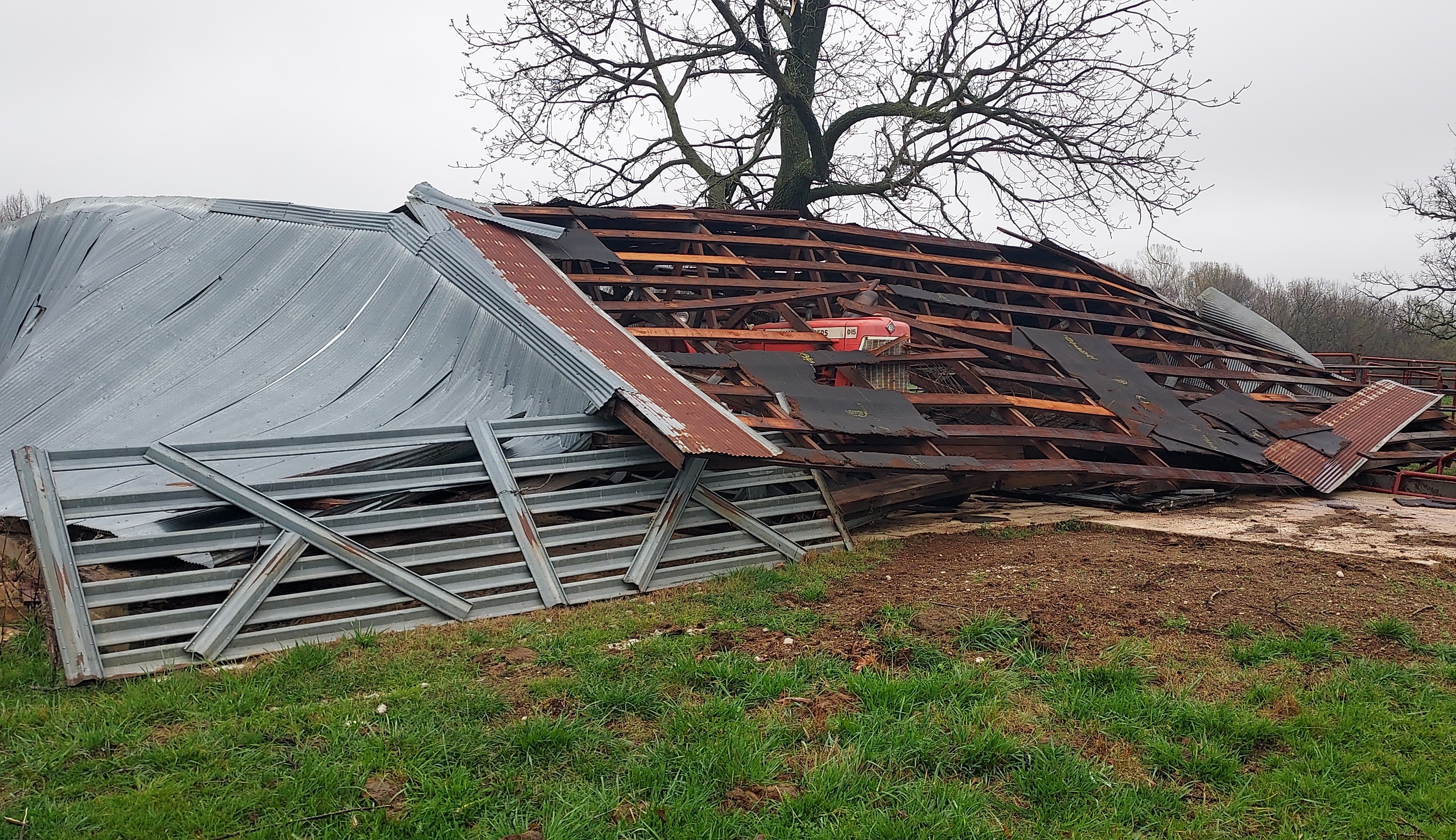
1024 PM Tstm Wnd Dmg 4 N Halltown 37.25N 93.63W
04/01/2024 Lawrence MO Emergency Mngr
Lost part of house roof and had substantial
tree damage.
1025 PM Tstm Wnd Dmg 4 N Halltown 37.25N 93.62W
04/01/2024 Lawrence MO NWS Storm Survey
NWS storm survey concluded that straight
line winds of 80 to 95 mph snapped and
uprooted trees as well as partially damaging
the roof and siding of a home.
1028 PM Tstm Wnd Dmg 3 N Halltown 37.24N 93.63W
04/01/2024 Lawrence MO Public
Public report of large trees down, full size
trampoline tosseed a quarter of a mile,
winds moving heavy playset, and smaller lawn
furniture swirled and moved. No photos.
1035 PM Tstm Wnd Dmg 4 NE Halltown 37.24N 93.58W
04/01/2024 Greene MO Amateur Radio
Trees blown over and limbs broken off.
1035 PM Tstm Wnd Dmg 1 S Pleasant Hope 37.45N 93.27W
04/01/2024 Polk MO Public
Photo of barn walls ripped and moved several
yards, forwarded by media via email. Time
estimated by radar.
1035 PM Tstm Wnd Dmg Morrisville 37.48N 93.43W
04/01/2024 Polk MO Public
1036 PM Tstm Wnd Dmg 1 E Brighton 37.46N 93.34W
04/01/2024 Polk MO Public
Uprooted tree reported with photo via
Facebook messenger, near Hwy 215 and 541st
road. Time estimated from radar.
1040 PM Tstm Wnd Dmg Ebenezer 37.34N 93.31W
04/01/2024 Greene MO Amateur Radio
Near the Fire Department on Hwy CC, multiple
photos of numerous trees down via
NWSChat2.0. Additional caller reported a hay
barn caved in, shingles and siding off, and
a small shed destroyed near the Ebenezer
Fire Department as well. Time estimated by
radar.
1043 PM Tstm Wnd Dmg 4 W Half Way 37.61N 93.32W
04/01/2024 Polk MO Public
Report from mPING: Trees uprooted or
snapped; Roof blown off.
1044 PM Tstm Wnd Dmg 4 SSE Pleasant Hope 37.41N 93.25W
04/01/2024 Greene MO Public
Facebook message with photos of structures
along FR 167. A wooden structure had the
metal roof halfway blown off, and two other
metal and wooden structures were completely
collapsed. Power lines also down. Time
estimated from radar.
1044 PM Tstm Wnd Dmg 5 NE Ebenezer 37.39N 93.26W
04/01/2024 Greene MO Public
Facebook photo reports of several downed
trees near Farm Road 167 and Hwy CC, many
trees uprooted as well. Time estimated from
radar.
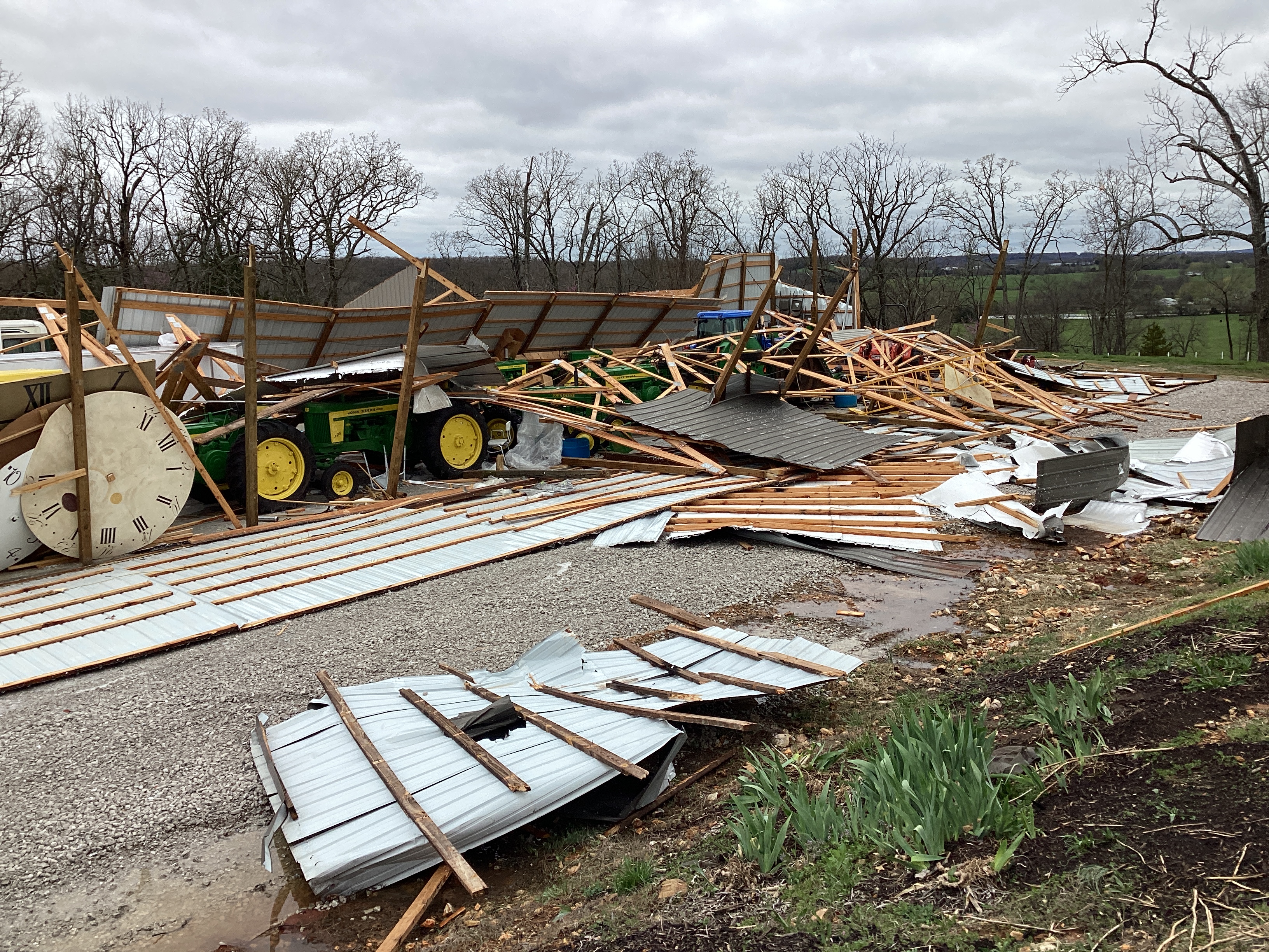
1044 PM Tstm Wnd Dmg 4 SSE Pleasant Hope 37.40N 93.26W
04/01/2024 Greene MO Public
Facebook photos with latitude and longitude
shared of a barn with a roof completely
removed, and sides of the barn caved in.
Many other items are also thrown about the
property. Time estimated from radar.
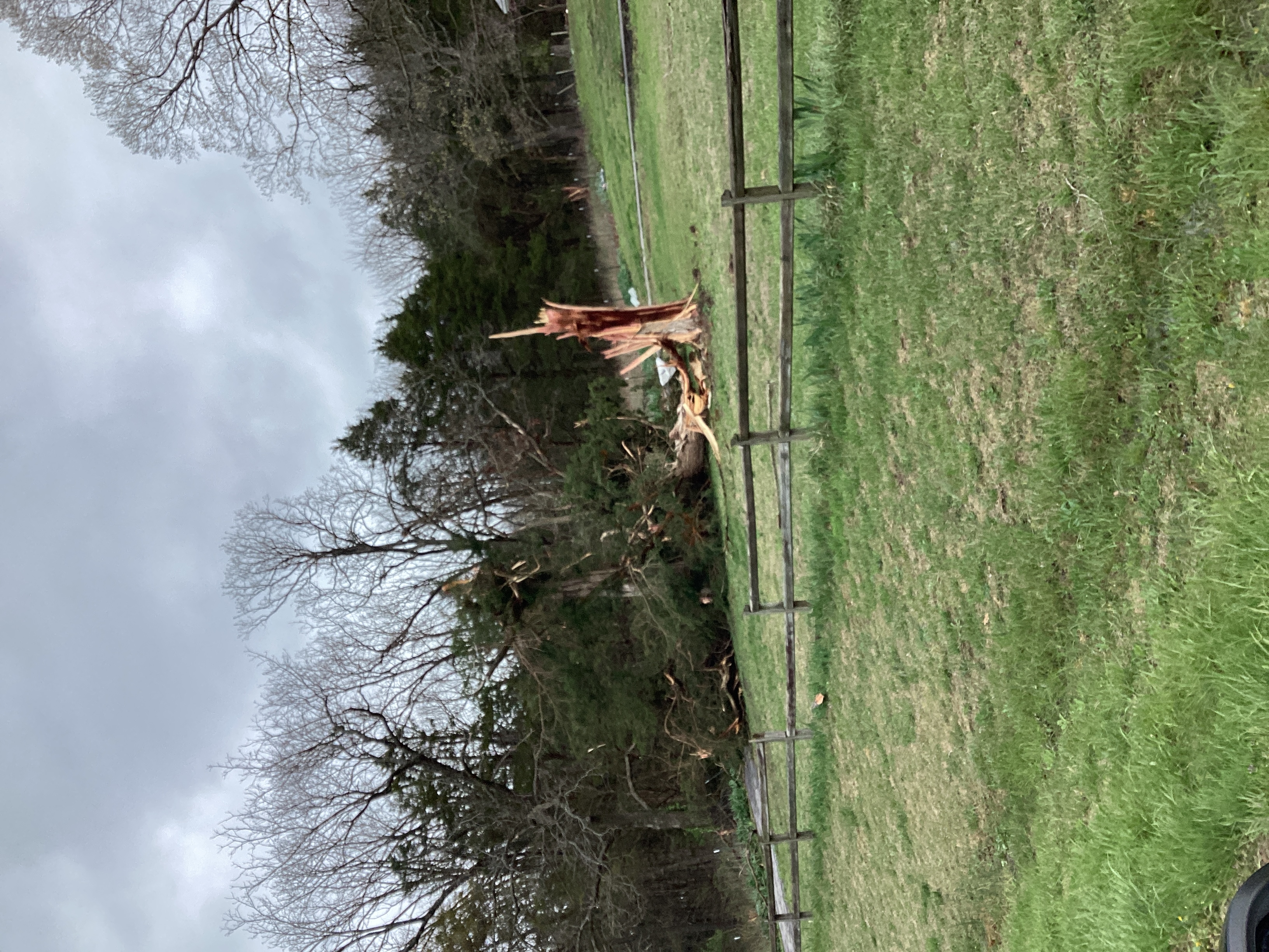
1047 PM Tstm Wnd Dmg 2 W Fair Grove 37.39N 93.19W
04/01/2024 Greene MO Public
Photo via Facebook of uprooted
tree at Hwy CC past FR 199 outside Fair
Grove city limits. Time estimated from
radar.
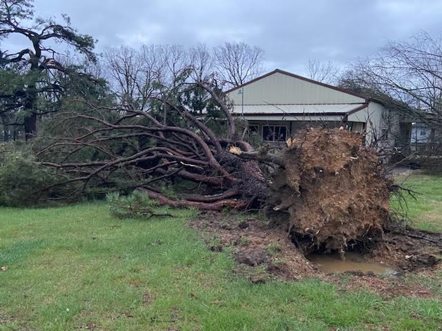
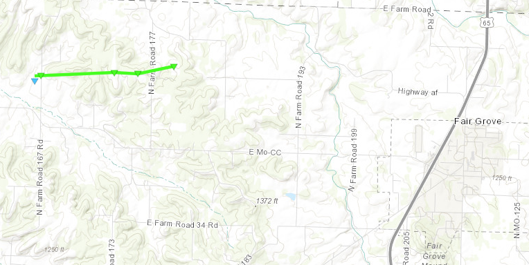
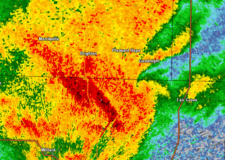
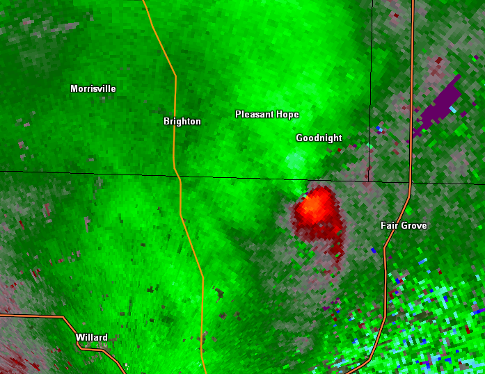
1047 PM Tornado 5 WNW Fair Grove 37.40N 93.26W
04/01/2024 Greene MO NWS Storm Survey
NWS storm survey concluded that an EF 1
tornado with peak winds of 95 mph occurred
near Fair Grove, Missouri. The width of the
tornado was 100 yards. The tornado remained
on the ground for nearly two miles while
uprooting and snapping several trees. The
tornado heavily damaged an outbuilding while
also causing minor damage to a residence. A
tornado debris signature was also present on
radar.
1048 PM Tstm Wnd Dmg 3 NW Fair Grove 37.42N 93.19W
04/01/2024 Polk MO Amateur Radio
Major tree damage down highway AF and farm
road 2 some are 6 to 8 inches in diameter
per polk EMD.
1051 PM Tstm Wnd Dmg 1 NE Fair Grove 37.40N 93.14W
04/01/2024 Greene MO Public
Photo report of uprooted tree in Fair Grove,
forwarded by media via email. Time estimated
by radar.
1051 PM Tstm Wnd Dmg 5 W Fair Grove 37.39N 93.24W
04/01/2024 Greene MO Public
Via social media. good size trees damaged
and a tree across the street.
1051 PM Tstm Wnd Dmg 1 SSE Olive 37.45N 93.10W
04/01/2024 Dallas MO Public
Near intersection of SR AA and SR O, minor
roof damage to shingles via Facebook photo.
Time estimated by radar.
1051 PM Tstm Wnd Dmg Fair Grove 37.39N 93.15W
04/01/2024 Greene MO Public
Facebook video report of large trees down,
fallen onto vehicle and home, and a
basketball hoop held down by bricks pushed
over as well. Across from high school. Time
estimated by radar.
1054 PM Tstm Wnd Dmg 1 NNE Fair Grove 37.39N 93.15W
04/01/2024 Greene MO Emergency Mngr
Photos sent via Fair Grove EM, within 2
blocks of high school, large tree limbs and
trees split, path looked west to east. Time
estimated by radar.
1054 PM Tstm Wnd Dmg 4 WNW Fair Grove 37.40N 93.23W
04/01/2024 Greene MO Fire Dept/Rescue
Numerous large trees and road signs down.
1055 PM Tstm Wnd Dmg Elkland 37.44N 93.03W
04/01/2024 Webster MO Public
Facebook photo report of tree limbs through
the roof penetrating into a room. Fixed
home, tree top estimated 7 to 8 inches in
diameter. Time estimated by radar.
1057 PM Tstm Wnd Dmg 4 SSW Elkland 37.40N 93.06W
04/01/2024 Webster MO Broadcast Media
Small trees down and wood fence down off Red
Fox Lane.
1058 PM Tstm Wnd Dmg 3 S Elkland 37.40N 93.03W
04/01/2024 Webster MO Emergency Mngr
Damage to barns and a house. Time estimated
from Radar.
1059 PM Tstm Wnd Dmg 3 S Elkland 37.40N 93.03W
04/01/2024 Webster MO NWS Storm Survey
NWS storm survey indicated straight line
wind speeds up to 75 mph uprooted a tree
which fell onto a house. Another residence
sustained minor roof damage. Multiple small
cedar trees were also snapped.
1100 PM Tstm Wnd Dmg 4 WNW Fair Grove 37.41N 93.22W
04/01/2024 Greene MO Public
Via X social media. Sizable pieces of sheet
metal partially wrapped around trees along N
Farm Road 185, and significant tree damage
along N Farm Road 177.Time based on radar.
1100 PM Tstm Wnd Dmg Elkland 37.44N 93.03W
04/01/2024 Webster MO Law Enforcement
Reports of trees down as well as some debris
in the roadways in the area of 38/Old
Hillcrest Rd in Elkland.
1106 PM Tornado 2 NE Long Lane 37.63N 92.87W
04/01/2024 Dallas MO NWS Storm Survey
NWS storm survey indicated an EF 0 tornado
with peak winds of 80 mph uprooted or
snapped over 200 trees as it moved east
southeast across extreme eastern Dallas and
extreme western Laclede Counties near theÂ
town of Long Lane. The tornado also rolled
an unanchored mobile home, damaged the roof
of a residence, and damaged multiple
outbuildings. The maximum width of the
tornado was 200 yards with a path length of
2.3 miles.
1109 PM Tstm Wnd Dmg 2 NNW Niangua 37.41N 92.84W
04/01/2024 Webster MO Public
Report via Facebook photo. Tree bark stripped,
nearly all branches of trees removed.
Roof of metal structure with small sections
of damage. Time estimated via radar.
1114 PM Tstm Wnd Dmg Brumley 38.09N 92.49W
04/01/2024 Miller MO Public
Facebook photo report of a tree with only
one side stripped of bark near Hwy 42 in
Brumley. Time estimated via radar.
1115 PM Tstm Wnd Gst 1 W Conway 37.50N 92.84W
04/01/2024 M53 MPH Laclede MO Mesonet
Mesonet station FW9621 Conway.
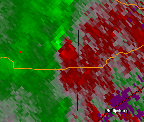
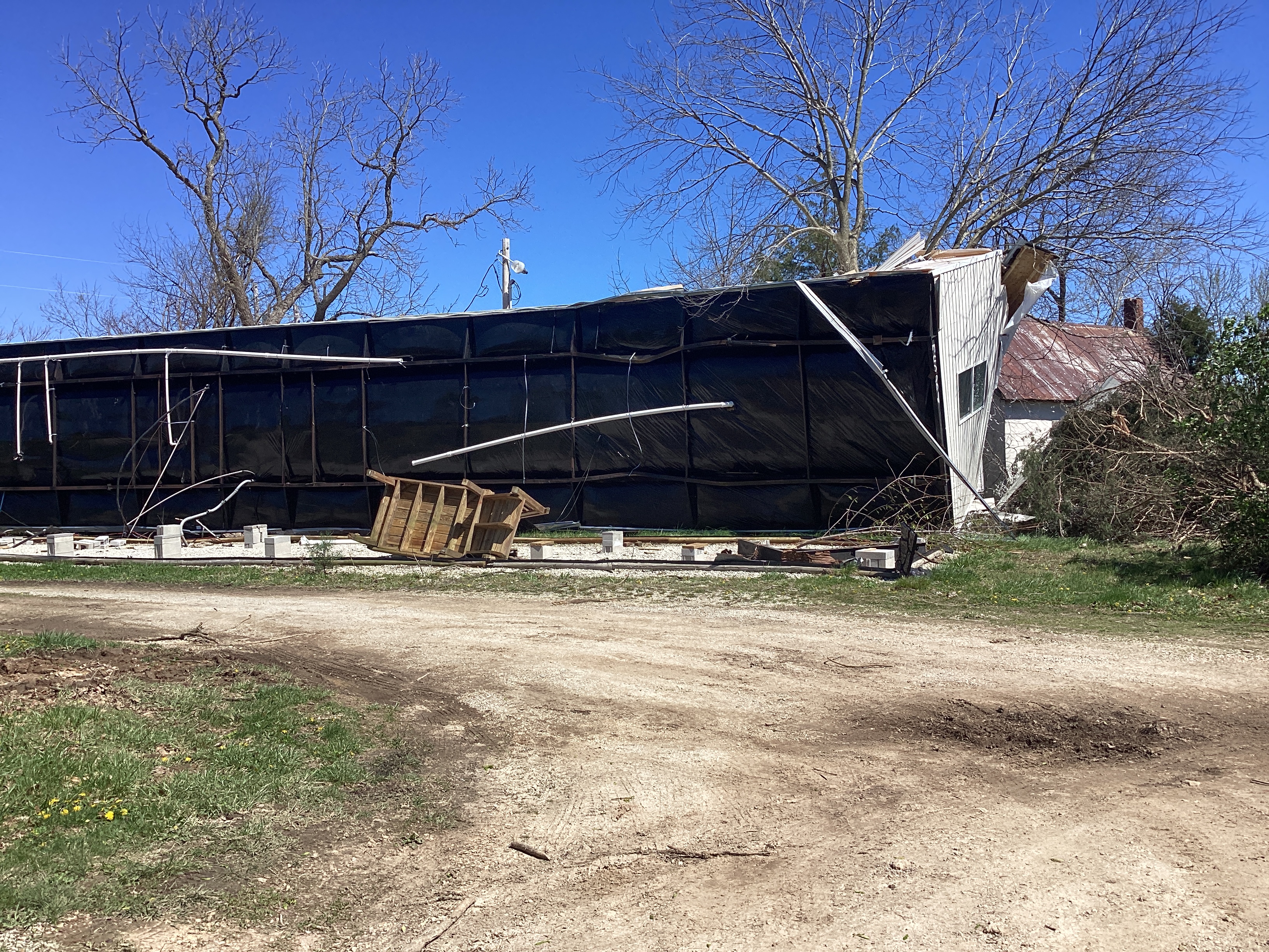
1120 PM Tornado Morgan 37.51N 92.68W
04/01/2024 Laclede MO NWS Storm Survey
NWS storm survey indicated an EF 0
tornado caused intermittent damage
to outbuildings and trees along
Highway J southeast of Phillipsburg.
Some trees were uprooted and a few
snapped with debris falling in a
convergent pattern. Tornado width
was 100 yards with maximum wind
speeds of 70 to 80 mph.
1120 PM Tstm Wnd Dmg 3 SSE Twin Bridges 37.51N 92.58W
04/01/2024 Laclede MO Public
Report forwarded via media through email.
Viewer called saying her roof is blown off
house and several outbuildings have damage.
Near HWY 5 and HWY O south of Lebanon.
Sounds like damage as far south as HWY J and
east of Morgan township. Photos confirmed
roof damage to home, barn structures with
roof of home completely removed and roof
debris scattered across property via email.
Time estimated from radar.
1120 PM Hail 3 NE Montreal 38.00N 92.55W
04/01/2024 E1.75 Inch Camden MO Emergency Mngr
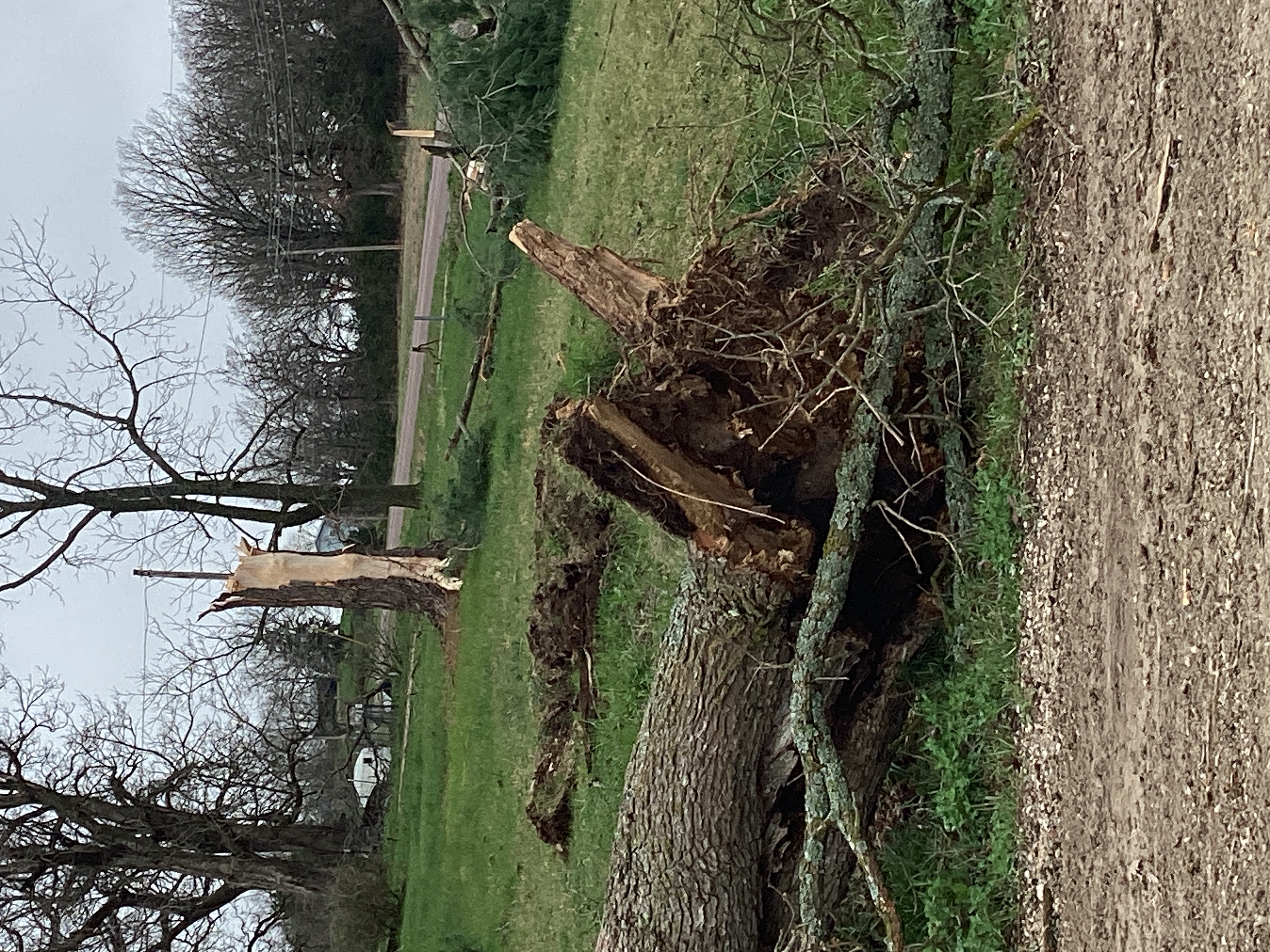
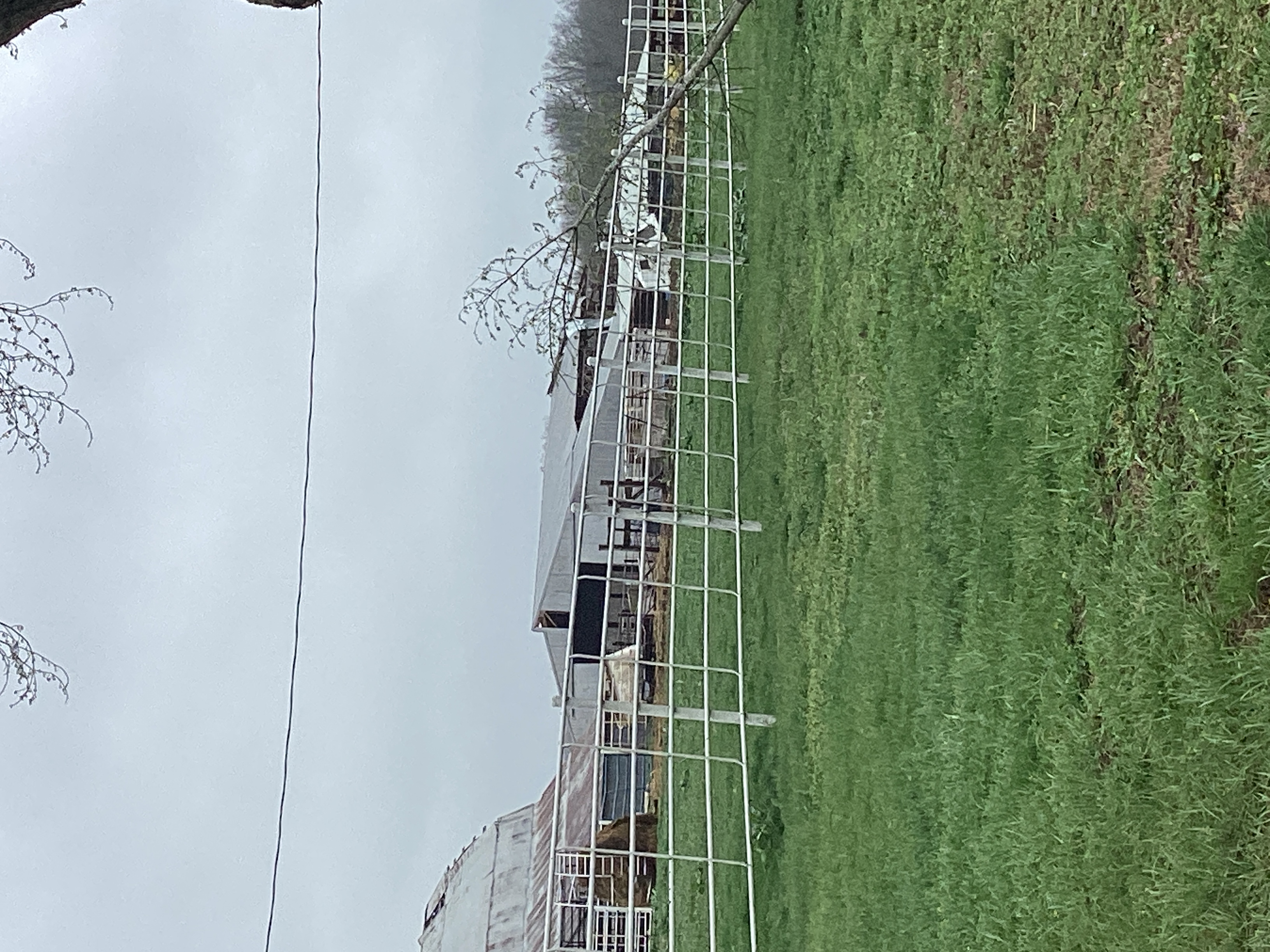
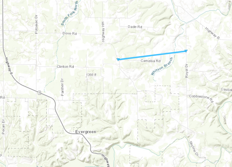
1124 PM Tornado 3 NNE Evergreen 37.58N 92.59W
04/01/2024 Laclede MO NWS Storm Survey
NWS storm survey concluded that an EF 0
tornado caused intermittent damage to
outbuildings including one large equipment
barn. The associated convergent debris
pattern of roofing panels and varying trees
extended eastward along Camelia Road between
Highway H and Royal Drive. Tornado width was
100 yards with maximum wind speeds of 80
mph.
1133 PM Tstm Wnd Dmg 4 NE Competition 37.52N 92.37W
04/01/2024 Laclede MO Public
Facebook photo report of trees down. Time
estimated from radar.
1134 PM Tstm Wnd Dmg 5 WSW Laquey 37.75N 92.39W
04/01/2024 Pulaski MO NWS Storm Survey
NWS storm survey concluded that straight
line winds up to 75 mph downed trees and
power lines. Trees were laying in an
easterly direction.
1136 PM Tstm Wnd Gst 4 ESE Stoutland 37.79N 92.45W
04/01/2024 E60 MPH Laclede MO Public
2 NW Hazelgreen, Laclede County. Pea sized
hail, winds est 50 to 60 MPH, power out.
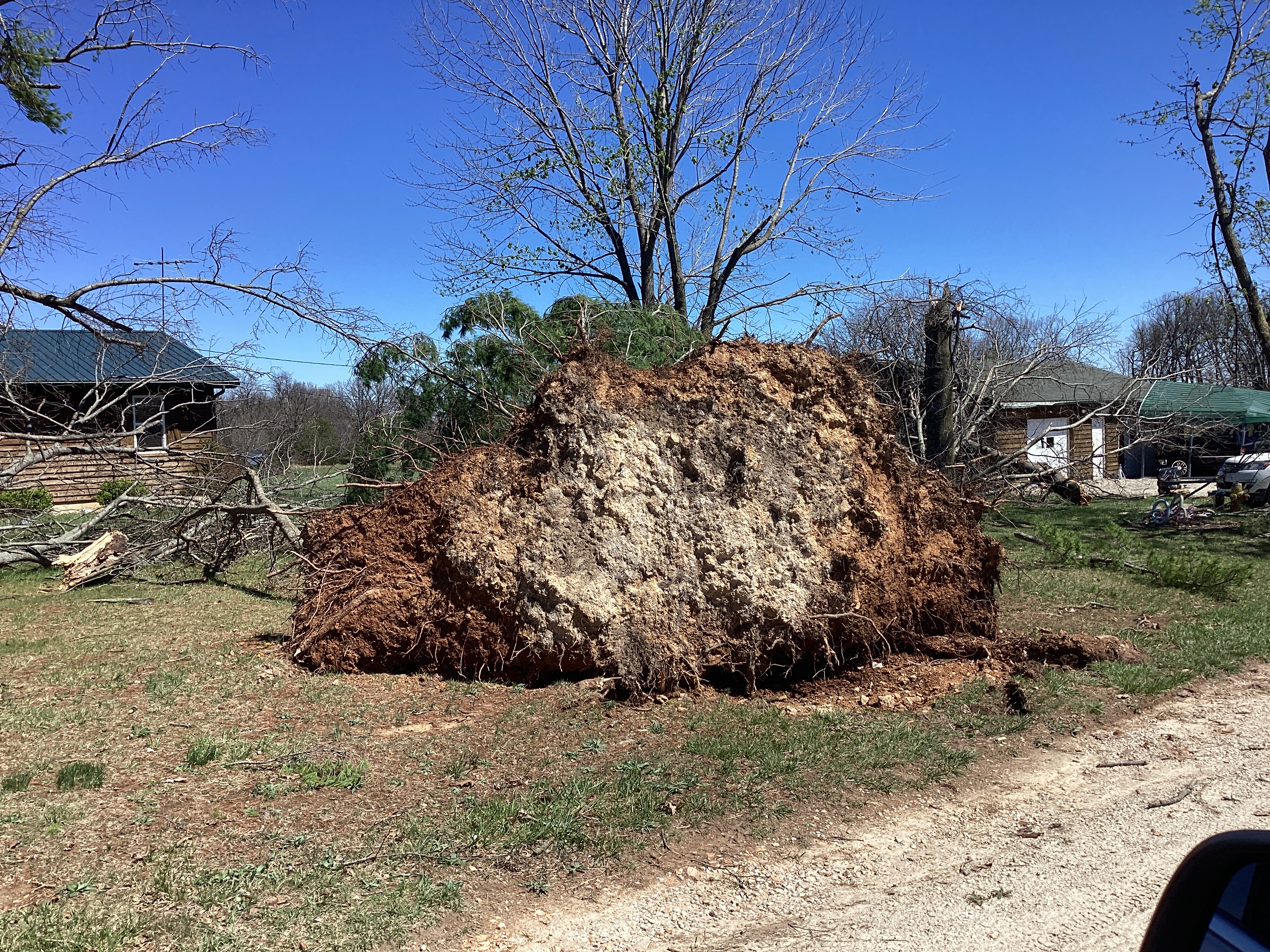
1140 PM Tstm Wnd Dmg 2 SW Waynesville 37.81N 92.22W
04/01/2024 Pulaski MO Public
Facebook photos of tree limbs down near Hull
Valley Dr and Tiger St. Time estimated via
radar.
1143 PM Tstm Wnd Dmg 5 SE Saint Robert 37.77N 92.12W
04/01/2024 Pulaski MO Public
Public report and photo via Facebook of
large, uprooted tree near intersection of
Sheppard St and Phoenix St in Fort Leonard
Wood. Time estimated by radar.
1143 PM Tstm Wnd Dmg 3 SSW Waynesville 37.78N 92.22W
04/01/2024 Pulaski MO Public
Facebook photo report of displaced
shingles on roof of home and an
uprooted tree. Time estimated by radar.
1143 PM Tstm Wnd Dmg W Waynesville 37.83N 92.19W
04/01/2024 Pulaski MO CO-OP Observer
COOP Observer reported holes in roof of
garage and house, house was not a mobile
home, built in the 20s. Shingles are all
over the yard and neighbors yards, very
large trees snapped clean in half. A screen
of a closed window underneath an awning was
blown apart, guttering was disrupted, an
iron bench and trash cans were moved by the
wind, satellite dish removed from concrete
base, roofs folded in half. Photos sent via
text to cell to confirm. Time estimated by
radar.
1144 PM Tstm Wnd Dmg 1 W Waynesville 37.83N 92.22W
04/01/2024 Pulaski MO Public
Facebook photo report of large trees
snapped at a residence on Elliott Dr.
Time estimated from radar.
1144 PM Tstm Wnd Dmg 4 ESE Ozark Springs 37.82N 92.27W
04/01/2024 Pulaski MO Public
Reported via Facebook messenger. Multiple
large trees down, one over a dirt road. Time
estimated via radar.
1148 PM Tstm Wnd Dmg 7 N Plato 37.60N 92.23W
04/01/2024 Texas MO Fire Dept/Rescue
5 large pine trees down along highway 17
before roubidoux creek bridge. Time
estimated from radar.
1149 PM Tstm Wnd Dmg 2 NE Montreal 37.98N 92.57W
04/01/2024 Camden MO Public
Report from mPING: 1-inch tree limbs broken;
Shingles blown off.
1150 PM Tstm Wnd Dmg 3 WSW Devils Elbow 37.83N 92.11W
04/01/2024 Pulaski MO Fire Dept/Rescue
Delayed reports. Large number of tree
branches and power lines down across central
Pulaski County. Time estimated from radar.
1150 PM Tstm Wnd Dmg 2 WSW Devils Elbow 37.84N 92.10W
04/01/2024 Pulaski MO Public
Facebook photo report of ripped billboard at
Road Ranger Truck Stop off I44 exit 163.
Time estimated by radar.
1151 PM Tstm Wnd Dmg 2 WSW Devils Elbow 37.83N 92.10W
04/01/2024 Pulaski MO Public
Facebook photo report tree stripped of bark
and multiple limbs displaced, with part of
the tree broken off and onto the roof of a
home. Sunset Village Hwy Z Saint Robert.
Time estimated by radar.
1155 PM Tstm Wnd Dmg 2 ESE Saint Robert 37.82N 92.14W
04/01/2024 Pulaski MO Public
Photos via media in NWSChat2.0. Ed Morse
Ford in St. Robert with damage of metal
stick embedded in a wall, and ceiling tiles
blown out of a structure. Time estimated
from radar.
1158 PM Tstm Wnd Dmg 3 ENE Devils Elbow 37.86N 92.01W
04/01/2024 Phelps MO Emergency Mngr
Delayed report. Porch ripped off, metal
buildings destroyed, and large trees
uprooted and branches removed on state route
p just east of route j.
1159 PM Tstm Wnd Dmg 4 NNW Devils Elbow 37.90N 92.09W
04/01/2024 Pulaski MO Public
Facebook report with photo of chicken coops
turned over and a barn with roof torn off of
it. Time estimated by radar.
1205 AM Tstm Wnd Dmg 1 NE Doolittle 37.95N 91.87W
04/02/2024 Phelps MO Public
Photo via email from Phelps county, just
north of I44 near mile marker 169 of large
trees completely uprooted and others are
snapped and tops twisted out. Diameters
range in size from 6 to 16 inches. Time
estimated via radar.
1207 AM Rain 6 E Ulman 38.18N 92.35W
04/02/2024 M3.60 Inch Miller MO Public
1212 AM Tstm Wnd Dmg 4 W Saint James 38.01N 91.68W
04/02/2024 Phelps MO Public
Report from mPING: Trees uprooted or
snapped; Roof blown off.
1216 AM Tstm Wnd Dmg Buffalo 37.65N 93.09W
04/02/2024 Dallas MO Public
Report from mPING: Trees uprooted or
snapped; Roof blown off.
1218 AM Tstm Wnd Dmg 4 W Saint James 38.01N 91.69W
04/02/2024 Phelps MO Public
Report from mPING: 3-inch tree limbs broken;
Power poles broken.
1218 AM Tstm Wnd Dmg 5 ESE Vichy 38.08N 91.68W
04/02/2024 Maries MO NWS Storm Survey
NWS Storm Survey found that 80 mph straight
line winds caused damage to outbuildings in
southeast Maries County.
1227 AM Tornado Saint James 38.00N 91.61W
04/02/2024 Phelps MO NWS Storm Survey
NWS Storm Survey found that a brief and
weak EF 0 tornado damaged small outbuildings
at an elementary school before causing
damage to a light pole at the football
stadium. A school camera showed footage of
the tornado as it crossed over a school
building. The tornado width was 10 yards and
the track length was a quarter mile.
0103 AM Tstm Wnd Dmg Blue Eye 36.50N 93.40W
04/02/2024 Stone MO Public
Metal from structures twisted, large trees
and poles down, twisted metal form structure
lodged in tree, barn damage to siding. Time
estimated from radar.
0130 AM Tstm Wnd Dmg 1 NNW Ridgedale 36.51N 93.23W
04/02/2024 Taney MO Public
Facebook photo report of several tree limbs
down.
 |
Media use of NWS Web News Stories is encouraged! Please acknowledge the NWS as the source of any news information accessed from this site. |
|


 Weather Story
 Weather Map
 Local Radar