Overview
A strong storm system tracked through the region during the evening hours on Friday April 13, 2018. A few super cell thunderstorms and several line segments developed across the Missouri Ozarks, that produce large hail, damaging winds, and four tornadoes. One supercell occurred across southern Taney County, which produced large hail of golf ball to tennis ball size and straight line winds around 70 mph. Line segments then developed producing four tornadoes, one EF-2 and three EF-1 tornadoes. The severe weather generally occurred east of Highway 65 and south of Interstate 44. Localized minor flooding also occurred across portions of south central Missouri will training of storms occurred.
Tornadoes:
|
|
|||||||||
|
|||||||||
|
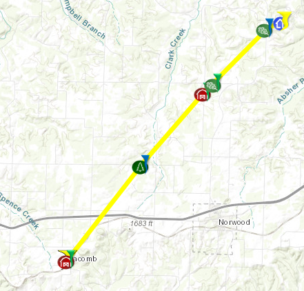
Tornado - Macomb, Missouri
KML Points: Macomb EF2 KML Points KML Path: Macomb EF2 KML Path Track Map 
|
||||||||||||||||
|
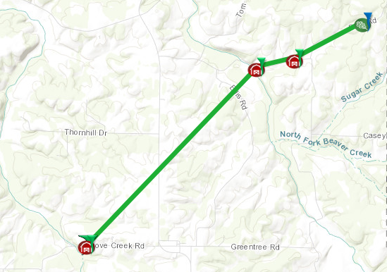
Tornado - Dawson, Missouri
KML Points: Dawson EF1 Points KML Path: Dawson EF1 Path Track Map
|
||||||||||||||||
|
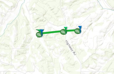
Tornado - 5 SW Success, Missouri
KML Points: Success EF1 Points KML Path: Success EF1 Path
Track Map
|
||||||||||||||||
|
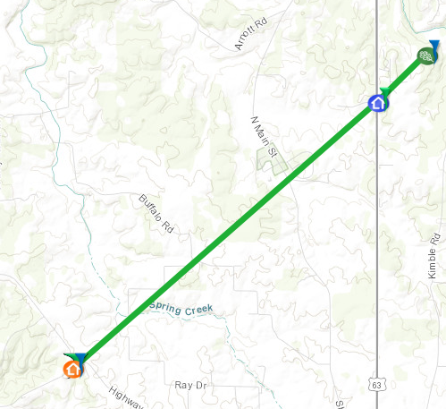
Tornado - 4 WNW Licking, Missouri
KML Points: Licking EF1 Points KML Path: Licking EF1 Path
Track Map
|
||||||||||||||||
The Enhanced Fujita (EF) Scale classifies tornadoes into the following categories:
| EF0 Weak 65-85 mph |
EF1 Moderate 86-110 mph |
EF2 Significant 111-135 mph |
EF3 Severe 136-165 mph |
EF4 Extreme 166-200 mph |
EF5 Catastrophic 200+ mph |
 |
|||||
Radar Loop for Friday evening April 13, 2018:

Storm Reports
Severe thunderstorms brought damaging winds, large hail up to the size of tennis balls, and four tornadoes
across the eastern Missouri Ozarks during the evening hours on Friday April 13, 2018.

..TIME...   ...EVENT...      ...CITY LOCATION...     ...LAT.LON...
..DATE...   ....MAG....      ..COUNTY LOCATION..ST.. ...SOURCE....
            ..REMARKS..

0401 PM     HAIL             2 SW CASSVILLE          36.66N 93.89W
04/13/2018  E1.00 INCH       BARRY              MO   EMERGENCY MNGR


0531 PM     HAIL             1 NE BLUE EYE           36.51N 93.39W
04/13/2018  E1.50 INCH       STONE              MO   PUBLIC

            PICTURE FROM PUBLIC.

0542 PM     TSTM WND GST     1 E HOLLISTER           36.62N 93.19W
04/13/2018  E65 MPH          TANEY              MO   NWS STORM SURVEY

            UPDATED TO INCLUDE WIND MAGNITUDE. NWS STORM
            SURVEY CONCLUDES THAT STRAIGHT-LINE WINDS
            ESTIMATED AT 65 MPH UPROOTED ONE TREE 18-24"
            IN DIAMETER. ANOTHER TREE WAS SPLIT. A LARGE
            SECTION OF FENCE WAS ALSO DESTROYED WITH
            MINOR SHINGLE DAMAGE TO A FEW HOUSES.

0549 PM     HAIL             4 ENE RIDGEDALE         36.53N 93.16W
04/13/2018  E1.75 INCH       TANEY              MO   PUBLIC

            PICTURE OF GOLFBALL SIZE HAIL NEAR HWY JJ
            AND PINETOP ROAD JUST EAST OF BRANSON
            AIRPORT.

0550 PM     TSTM WND GST     POWERSITE               36.66N 93.13W
04/13/2018  E70 MPH          TANEY              MO   NWS STORM SURVEY

            NWS STORM SURVEY REVEALED THAT STRAIGHT-LINE
            WIND GUSTS OF 70 MPH SNAPPED MULTIPLE CEDAR
            TREES.

0555 PM     TSTM WND GST     4 SSE POWERSITE         36.61N 93.10W
04/13/2018  E70 MPH          TANEY              MO   NWS STORM SURVEY

            NWS STORM SURVEY CONCLUDED THAT
            STRAIGHT-LINE WINDS OF 70 MPH DAMAGED
            MULTIPLE BOAT DOCKS. THE DOCK OWNERS STATED
            THAT THE STRONG WINDS LASTED ABOUT 10
            MINUTES.

0555 PM     HAIL             3 SSE POWERSITE         36.61N 93.10W
04/13/2018  E2.50 INCH       TANEY              MO   PUBLIC

            CORRECTS PREVIOUS HAIL REPORT FROM 3 SSE
            POWERSITE. GOLF BALL TO TENNIS BALL SIZE
            HAIL LASTED TEN MINUTES.

0556 PM     TSTM WND DMG     OZARK BEACH             36.66N 93.13W
04/13/2018                   TANEY              MO   AMATEUR RADIO

            3 FOOT DIAMETER TREES DOWN EMPIRE PARK
            POWERSITE.

0556 PM     TSTM WND DMG     1 E FORSYTH             36.69N 93.10W
04/13/2018                   TANEY              MO   LAW ENFORCEMENT

            SHADOW ROCK DAMAGE TO THE DOCK, TREES DOWN,
            ROOF DAMAGE AND HWY 160 CLOSED DUE TO DAMAGE
            AND DEBRIS.

0600 PM     HAIL             5 SE POWERSITE          36.60N 93.07W
04/13/2018  E1.50 INCH       TANEY              MO   PUBLIC

            HOLES IN THE SIDING OF HOUSE AND SEVERAL
            NEIGHBORS HOUSES.

0602 PM     HAIL             KIRBYVILLE              36.62N 93.16W
04/13/2018  E1.75 INCH       TANEY              MO   LAW ENFORCEMENT


0626 PM     HAIL             GOODHOPE                36.91N 92.80W
04/13/2018  E1.00 INCH       DOUGLAS            MO   AMATEUR RADIO


0710 PM     TSTM WND DMG     4 WSW NORWOOD           37.09N 92.49W
04/13/2018                   WRIGHT             MO   PUBLIC

            DAMAGE REPORTED TO BUILDINGS AND TREES NEAR
            MACOMB MISSOURI BY PUBLIC AND SOCIAL MEDIA.
            POSSIBLE TORNADO DAMAGE.

0713 PM     TORNADO          MACOMB                  37.10N 92.49W
04/13/2018                   WRIGHT             MO   NWS STORM SURVEY

            AN EF-1 TORNADO 100 YARDS WIDE WITH
            ESTIMATED MAXIMUM WIND SPEEDS OF 100 MPH
            TRACKED FROM NEAR MACOMB NORTHEASTWARD FOR 6
            MILES BEFORE LIFTING 4 MILES NORTH OF
            NORWOOD. NUMEROUS TREES WERE UPROOTED AND
            SNAPPED, AND OUTBUILDINGS WERE DAMAGED.

0735 PM     TORNADO          1 W DAWSON              37.26N 92.33W
04/13/2018                   WRIGHT             MO   NWS STORM SURVEY

            AN EF-1 TORNADO WITH MAXIMUM WIDTH OF 75
            YARDS AND MAXIMUM WINDS OF 100 MPH MOVED
            NORTHEAST FROM DOVE CREEK ROAD TO BATY ROAD.
            TREES AND OUTBUILDINGS WERE DAMAGED.

0800 PM     TORNADO          5 SW SUCCESS            37.39N 92.15W
04/13/2018                   TEXAS              MO   NWS STORM SURVEY

            AN EF-1 TORNADO WITH MAXIMUM WIDTH OF 50
            YARDS AND MAXIMUM WINDS OF 95 MPH DAMAGED A
            ROOF, CARPORT, OUTBUILDING AND TREES ALONG A
            ONE AND A QUARTER MILE PATH FROM 5 MILES
            SOUTHWEST OF SUCCESS TO ONE HALF MILE EAST
            OF HIGHWAY AJ.

0800 PM     TSTM WND DMG     BUCYRUS                 37.35N 92.02W
04/13/2018                   TEXAS              MO   PUBLIC

            DAMAGE TO METAL CARPORT, ROOF OF HOUSE AND
            TREES. ROOF OF METAL CARPORT THROWN 1/10 TO
            1/4 MILE. TIME ESTIMATED BY RADAR.

0820 PM     TORNADO          4 WNW LICKING           37.53N 91.92W
04/13/2018                   TEXAS              MO   NWS STORM SURVEY

            AN EF-1 TORNADO WITH MAXIMUM WINDS OF 100
            MPH AND MAXIMUM WIDTH OF 50 YARDS DAMAGED A
            HOUSE, VACANT MOBILE HOME, AND NUMEROUS
            TREES WERE SNAPPED AND UPROOTED. THE PATH
            LENGTH WAS FIVE MILES AND EXTENDED FROM 4
            MILES WNW OF LICKING ALONG HIGHWAY 32 TO 5
            MILES SOUTHEAST OF BEULAH NEAR SHERRILL
            CREEK.

0830 PM     TSTM WND DMG     4 SE WEST PLAINS        36.69N 91.80W
04/13/2018                   HOWELL             MO   EMERGENCY MNGR

            A BARN WAS BLOWN DOWN AND TREES WERE
            DAMAGED. WIND SPEEDS WERE ESTIMATED TO BE
            AROUND 80 MPH.

0845 PM     TSTM WND DMG     WILLOW SPRINGS          36.99N 91.97W
04/13/2018                   HOWELL             MO   EMERGENCY MNGR

            LIMBS DOWN IN TOWN.

0848 PM     TSTM WND DMG     SALEM                   37.64N 91.54W
04/13/2018                   DENT               MO   EMERGENCY MNGR

            SOME ROOF DAMAGE AND POWER LINES DOWN.

0952 PM     FLASH FLOOD      4 WNW AVA               36.96N 92.72W
04/13/2018                   DOUGLAS            MO   DEPT OF HIGHWAYS

            ROUTE Y CLOSED AT COW SKIN CREEK.

0952 PM     FLASH FLOOD      3 E AVA                 36.95N 92.61W
04/13/2018                   DOUGLAS            MO   DEPT OF HIGHWAYS

            ROUTE FF FLOODED AND CLOSED AT HUNTER CREEK.

0952 PM     FLASH FLOOD      5 NE MANSFIELD          37.17N 92.53W
04/13/2018                   WRIGHT             MO   DEPT OF HIGHWAYS

            ROUT AB IS CLOSED AT WOLF CREEK DUE TO
            FLOODING.

0952 PM     FLASH FLOOD      4 NNW BRUSHYKNOB        37.01N 92.52W
04/13/2018                   DOUGLAS            MO   DEPT OF HIGHWAYS

            ROUTE U CLOSED AT BRYANT CREEK.
 |
Media use of NWS Web News Stories is encouraged! Please acknowledge the NWS as the source of any news information accessed from this site. |
|


 Weather Story
 Weather Map
 Local Radar