Overview
|
A cold front moved through southeast Kansas and the Missouri Ozarks on Thursday bringing a shallow cold air mass to the area. The freezing line made it to the Missouri/Arkansas border. Freezing rain moved into the area late Thursday night from the south. Minor icing occurred along the Arkansas border due to warm temperatures hovering around 32 degrees. Heavier icing occurred north of a line from near Joplin to just north of Springfield, to near Salem, where ¼ to ½ inch of ice accretion was common on elevated objects, with some local ¾ inch amounts. This was in area where temperatures remained in the upper 20s. Several other waves of rain/freezing rain brought more icing to the region Saturday and again early Sunday morning. |
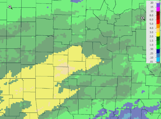
 Ice Accumulation Amounts |
Storm Reports
...Freezing Rain Reports...
Location Amount Time/Date Lat/Lon
...Kansas...
...Cherokee County...
Columbus 0.60 in 0835 AM 01/15 37.17N/94.84W
...Crawford County...
Frontenac 0.30 in 0731 AM 01/15 37.46N/94.69W
Pittsburg 0.25 in 1012 PM 01/14 37.41N/94.71W
2 NNW Opolis 0.25 in 0554 AM 01/15 37.37N/94.64W
PTSK1 0.25 in 0600 AM 01/15 37.36N/94.64W
Frontenac 0.20 in 0857 PM 01/14 37.46N/94.69W
Pittsburg 0.20 in 0917 PM 01/14 37.41N/94.71W
2 NW Opolis 0.15 in 0600 AM 01/14 37.36N/94.64W
2 NW Opolis 0.00 in 0600 AM 01/13 37.36N/94.64W
...Missouri...
...Barry County...
Monett 0.00 in 0800 AM 01/13 36.92N/93.93W
Cassville 0.00 in 0830 AM 01/13 36.68N/93.87W
Exeter 0.00 in 1158 AM 01/13 36.67N/93.94W
...Barton County...
1 N Irwin 0.50 in 0630 AM 01/15 37.60N/94.28W
1 NNE Irwin 0.00 in 0630 AM 01/13 37.60N/94.28W
Liberal 0.00 in 0848 AM 01/13 37.56N/94.52W
...Benton County...
CCMM7 0.15 in 0700 AM 01/15 38.48N/93.26W
1 W Whitakerville 0.10 in 0230 AM 01/15 38.21N/93.38W
3 WNW Cole Camp 0.00 in 0700 AM 01/14 38.48N/93.26W
...Camden County...
4 WSW Old Linn Creek 0.50 in 0658 AM 01/15 38.05N/92.80W
2 WSW Old Linn Creek 0.25 in 0230 PM 01/13 38.06N/92.77W
4 WSW Old Linn Creek 0.10 in 1145 AM 01/13 38.05N/92.80W
4 WSW Old Linn Creek 0.10 in 1145 AM 01/13 38.05N/92.80W
Camdenton 0.08 in 1212 PM 01/13 38.01N/92.74W
4 WSW Old Linn Creek 0.00 in 0800 AM 01/13 38.05N/92.80W
...Cedar County...
1 NNW Cedarville 0.50 in 0858 AM 01/15 37.59N/93.99W
1 NW Cedarville 0.25 in 0700 AM 01/14 37.58N/93.99W
1 NNW Cedarville 0.25 in 0845 AM 01/14 37.59N/93.99W
Stockton 0.10 in 0930 PM 01/14 37.70N/93.80W
...Dade County...
1 ENE Dudenville 0.25 in 1007 AM 01/14 37.31N/94.08W
Lockwood 0.20 in 0700 AM 01/14 37.39N/93.95W
Greenfield 0.16 in 1208 PM 01/13 37.42N/93.84W
Lockwood 0.00 in 0700 AM 01/13 37.39N/93.95W
...Dallas County...
2 NNW Buffalo 0.25 in 0721 AM 01/15 37.68N/93.11W
...Dent County...
Salem 0.00 in 0858 AM 01/13 37.65N/91.54W
Salem 0.00 in 0810 AM 01/13 37.65N/91.54W
...Greene County...
2 NE I-44 Near Mile Mar 0.44 in 0225 AM 01/14 37.23N/93.40W
3 ENE Springfield 0.30 in 0102 PM 01/13 37.22N/93.24W
2 NE Halltown 0.25 in 1050 AM 01/14 37.22N/93.60W
Willard 0.20 in 0800 AM 01/13 37.30N/93.43W
2 NE I-44 Near Mile Mar 0.20 in 1010 AM 01/13 37.23N/93.40W
Springfield 0.14 in 1202 PM 01/13 37.20N/93.29W
Springfield 0.14 in 1202 PM 01/13 37.20N/93.29W
Springfield 0.00 in 1100 AM 01/13 37.20N/93.29W
...Hickory County...
Hermitage 0.25 in 1200 PM 01/13 37.94N/93.32W
...Howell County...
1 NNE Pomona 0.16 in 0235 AM 01/14 36.88N/91.91W
1 NNE Pomona 0.02 in 0653 AM 01/13 36.88N/91.91W
...Jasper County...
1 N Webb City 0.43 in 0800 PM 01/14 37.16N/94.48W
Oakland Park 0.39 in 1000 PM 01/14 37.11N/94.48W
Webb City 0.38 in 0227 AM 01/14 37.15N/94.49W
Joplin 0.25 in 1150 AM 01/13 37.08N/94.51W
Joplin 0.25 in 1150 AM 01/13 37.08N/94.51W
2 NW I-44 Near Mile Mar 0.00 in 0845 PM 01/14 37.10N/94.31W
3 E Waco 0.00 in 0927 PM 01/14 37.24N/94.54W
3 NNE Alba 0.00 in 0927 PM 01/14 37.28N/94.39W
Joplin 0.00 in 0812 AM 01/13 37.08N/94.51W
...Laclede County...
2 E Conway 0.30 in 0935 AM 01/13 37.50N/92.78W
Conway 0.30 in 0942 AM 01/13 37.50N/92.82W
Lebanon 0.25 in 0207 PM 01/13 37.68N/92.66W
Lebanon 0.25 in 0207 PM 01/13 37.68N/92.66W
Competition 0.25 in 0920 AM 01/13 37.48N/92.43W
Lebanon 0.20 in 0903 AM 01/13 37.68N/92.66W
Conway 0.00 in 0935 PM 01/14 37.50N/92.82W
...Lawrence County...
2 N Mount Vernon 0.10 in 1053 AM 01/13 37.13N/93.82W
...Maries County...
2 SE Vichy 0.25 in 0231 AM 01/14 38.09N/91.73W
...Miller County...
1 NNW Iberia 0.38 in 0700 AM 01/15 38.10N/92.30W
3 E Brumley 0.25 in 0855 AM 01/14 38.08N/92.43W
...Morgan County...
3 NW Stover 0.12 in 0758 AM 01/14 38.47N/93.02W
Laurie 0.00 in 0950 AM 01/13 38.20N/92.83W
...Newton County...
Wentworth 0.00 in 0835 AM 01/13 36.99N/94.07W
Granby 0.00 in 0840 AM 01/13 36.92N/94.25W
...Ozark County...
1 N Dora 0.00 in 0700 AM 01/13 36.79N/92.22W
...Phelps County...
Rolla 0.25 in 1157 AM 01/13 37.95N/91.77W
Rolla 0.00 in 0905 AM 01/13 37.95N/91.77W
...Polk County...
3 WSW Aldrich 0.75 in 0205 PM 01/13 37.54N/93.60W
1 SW Morrisville 0.50 in 0848 AM 01/15 37.47N/93.44W
1 SW Morrisville 0.35 in 0841 AM 01/14 37.47N/93.44W
Bolivar 0.15 in 1254 PM 01/13 37.61N/93.41W
3 ESE Flemington 0.13 in 0700 AM 01/14 37.79N/93.45W
3 E Flemington 0.13 in 0906 AM 01/14 37.80N/93.45W
...Pulaski County...
2 SW Waynesville 0.75 in 0220 PM 01/14 37.81N/92.23W
Saint Robert 0.00 in 0810 AM 01/13 37.83N/92.18W
...Shannon County...
Eminence 0.00 in 0800 AM 01/14 37.15N/91.36W
1 NNW Eminence 0.00 in 0700 AM 01/13 37.16N/91.36W
...Texas County...
Roby 0.25 in 0936 AM 01/13 37.52N/92.14W
Bucyrus 0.09 in 1023 AM 01/13 37.34N/92.02W
1 SSW Houston 0.00 in 1125 AM 01/13 37.31N/91.96W
...Webster County...
3 NNE Northview 0.33 in 1255 PM 01/13 37.32N/92.97W
3 NNE Northview 0.33 in 1255 PM 01/13 37.32N/92.97W
3 NNE Northview 0.30 in 1042 AM 01/13 37.32N/92.97W
Marshfield 0.25 in 1153 AM 01/13 37.34N/92.91W
Marshfield 0.25 in 1153 AM 01/13 37.34N/92.91W
2 S Elkland 0.25 in 0933 AM 01/13 37.41N/93.03W
Marshfield 0.15 in 1133 AM 01/13 37.34N/92.91W
Niangua 0.00 in 0953 AM 01/13 37.39N/92.83W
...Wright County...
4 S Competition 0.25 in 0930 AM 01/13 37.43N/92.43W
2 S Manes 0.25 in 0241 PM 01/13 37.35N/92.37W
Observations are collected from a variety of sources with varying
equipment and exposures. Not all data listed are considered official.
Rain Reports
 |
Media use of NWS Web News Stories is encouraged! Please acknowledge the NWS as the source of any news information accessed from this site. |
|


 Weather Story
 Weather Map
 Local Radar