...The First Winter Storm of the 2003-2004 Season...
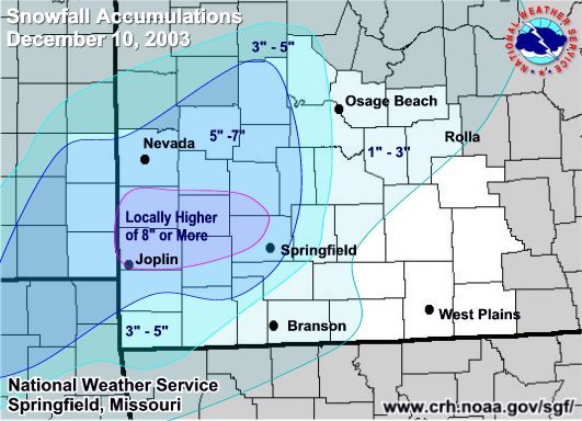
A strong storm brought near blizzard conditions to portions of the Missouri Ozarks and southeast Kansas Tuesday night. "Bursts" of snow produced accumulation rates of three inches per hour for brief periods. Cooperative and volunteer weather observers in the Carthage and Lamar areas reported local amounts in excess of nine inches of snow with the storm. Near Springfield in Greene County, National Weather Service employees who live in the northwest and north central portions of the county reported seven to eight inches of snow.
Public information statement
National Weather Service Springfield Mo
946 AM CST Wed Dec 10 2003
...FIRST WINTER STORM OF THE 2003 - 2004 COLD SEASON...
A very dynamic upper level storm system passed over extreme
Southeast Kansas and the Missouri Ozarks overnight. This feature
Was responsible for inducing a variety of hazardous weather over the
Last 24 hours. Thunderstorms developed early Tuesday morning which
Brought hail to areas of extreme southeast Kansas...while minor
Flash flooding was observed in a few communities of southern
Missouri.
During the overnight hours...a much colder airmass surged into the
Region which caused ongoing showers and thunderstorms to change into
Sleet and eventually snow. Snow accumulations were heaviest over
Extreme southeast Kansas and southwest Missouri where storm totals
Ranged from 6 to 8 inches in most locations. Lighter amounts were
Observed over central and south central Missouri. Several southwest
Missourians experienced thunder snow last night which enhanced snow
Amounts near the Joplin area and rural areas north and east of
Pittsburg Kansas. Along with the rare occurrence of thunder snow in
The Ozarks...several locations experienced near blizzard conditions
As northwest winds sustained at 20 to 30 mph were common. In
Locations within the Osage plains of southeast Kansas and west
Central Missouri...gusts of over 40 mph occurred making travel
extremely treacherous. .
The following are unofficial storm total snowfall accumulations in
Inches from the December 9th - 10th 2003 winter storm.
County Snow Accumulation (Inches)
Barry..........3 - 6
Barton........6 - 8
Benton........1 - 4
Bourbon......4 - 6
Camden......1 - 3
Cedar..........4 - 6
Cherokee....4 - 6
Christian......1 - 4
Crawford.....5 - 7
Dade..........6 - 8
Dallas.........3 - 5
Dent...........0 - 1
Douglas......0 - 2
Greene........4 - 7
Hickory......3 - 5
Howell.......0 - 1
Jasper........6 - 8
Laclede......2 - 3
Lawrence....4 - 7
Maries........1 - 3
Mcdonald...3 - 6
Miller.........1 - 3
Morgan......1 - 3
Newton......4 - 6
Oregon......0 - T
Ozark........0 - 2
Phelps.......1 - 2
Polk...........4 - 7
Pulaski......1 - 3
Taney........1 - 3
Texas.........0 - 1
Shannon.....0 - 1
St. Clair.....3 - 6
Stone.........2 - 4
Webster.....2 - 4
Wright.......1 - 3
Vernon......3 - 7
$$


 Weather Story
 Weather Map
 Local Radar