Springfield, MO
Weather Forecast Office
 |
Flooding - August 19th-20th, 2007National Weather Service, Springfield, MO |
 |
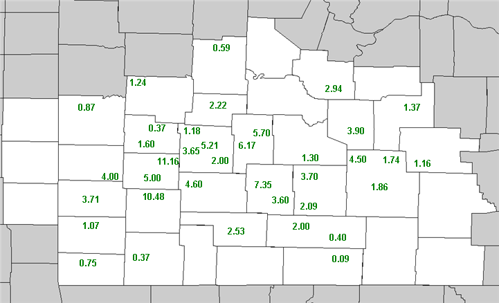
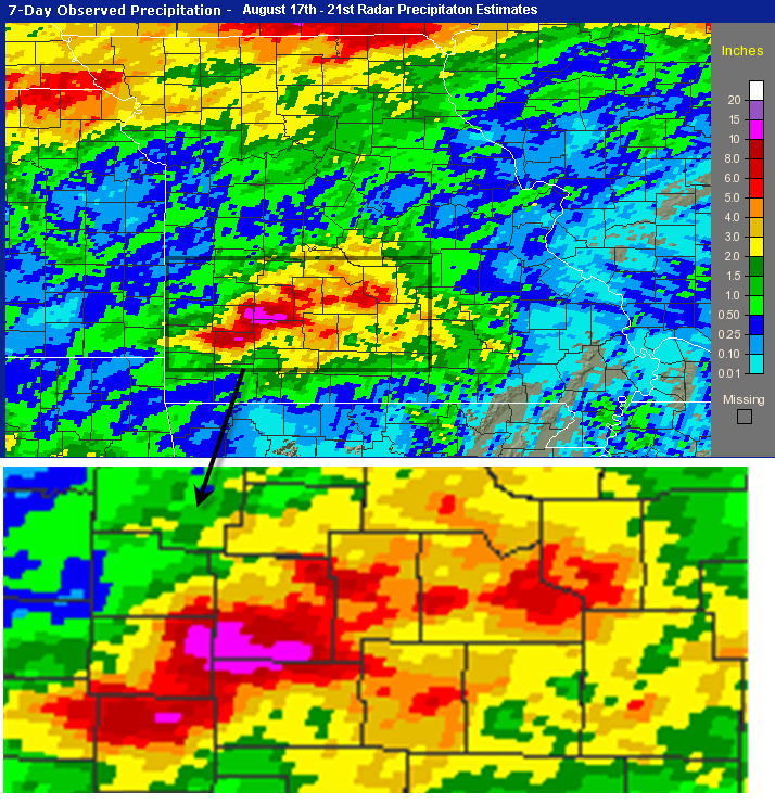
Heavy rainfall and flash flooding occurred over the Missouri Ozarks and southeast Kansas over the 19th and 20th of August. The heavy rain was a result of the remnant energy from tropical system "Erin" as it interacted with high levels of moisture in the atmosphere.
The heaviest rainfall occurred in a band that affected northern Lawrence, Eastern Dade, northern Greene and southern Polk counties where 10 to 12 inches of rainfall occurred. Most of this heavy rain occurred in a short period of time on the morning of the 20th. Despite the little to no rainfall for the first 18 days of August and very dry antecedent conditions, serious flash flooding was able to occur due to the record amounts of rainfall that occurred on the 20th.
Showers associated with an initial wave of energy from the remnants of "Erin" began developing over southeast Kansas and Western Missouri on the morning of the 19th. These showers lifted northeast during the day and into central Missouri by the late afternoon but tracked over an area which would see much heavier rain for a longer period of time the next day.
Showers began to redevelop during the evening in advance of the next wave of energy over southeast Kansas and northeast Oklahoma , and then were greatly enhanced as a low level jet stream began to develop during the overnight hours.
From around 3 AM through around 11 am, the heaviest rain affected the locations which would wind up receiving between 10 to 12 inches of rain. Tropical moisture, high radar reflectivities and slow movement to the storms led to the powerful flash flooding which ripped up roadways, bridges, and caused one death in Laclede county.
Current Hazards
Experimental Graphical Hazardous Weather Outlook
Submit a storm report
Local Storm Reports
Current Conditions
Observations
Lake Levels
Snowfall Analysis
Road Conditions
Satellite
CoCoRaHS
Graphical Conditions
Precip. Analysis
Forecasts
Forecast Discussion
Fire Weather
Aviation
GIS Forecast Maps
Activity Planner
Severe Weather
Winter Weather
Hurricanes
FAA Center Weather
Space Weather
Climatology
Records and Normals
Monthly Climate Summary
Local
National
Drought
Climate Science
Astronomical Data
US Dept of Commerce
National Oceanic and Atmospheric Administration
National Weather Service
Springfield, MO
Springfield-Branson National Airport
5805 West Highway EE
Springfield, MO 65802-8430
Business: 417-863-8028 Recording: 417-869-4491
Comments? Questions? Please Contact Us.


 Weather Story
 Weather Map
 Local Radar