Springfield, MO
Weather Forecast Office
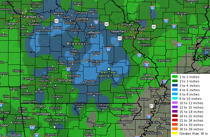
An upper level storm system brought accumulating snow to the region from late Sunday night into Monday evening. Snow accumulations generally ranged from around an inch near the Highway 71 corridor, to upwards of four inches across the eastern Missouri Ozarks. Many locations also received a thin glaze of ice due to occasional rounds of freezing drizzle. With the warm temperatures that were observed on Tuesday, many locations have already melted off most of the snow.
Here is a summary of reports:
SNOW REPORTS LISTED BY AMOUNT

 INCHES  LOCATION                 ST  COUNTY           TIME
 ------  -----------------------  --  --------------   -------
  4.50   PLATO                    MO  TEXAS            0433 PM
  4.00   6 W IBERIA               MO  MILLER           0752 PM
  4.00   VICHY                    MO  MARIES           0736 PM
  4.00   ROLLA                    MO  PHELPS           0513 PM
  4.00   MANSFIELD                MO  WRIGHT           0415 PM
  3.80   HIGHLANDVILLE            MO  CHRISTIAN        0433 PM
  3.00   MONETT                   MO  BARRY            0433 PM
  3.00   RICHLAND                 MO  PULASKI          0433 PM
  3.00   WEST PLAINS              MO  HOWELL           0232 PM
                 THREE INCHES OF SNOW FELL FROM 6AM TO 2PM
                 TODAY. AT TIME OF REPORT SNOW WAS CHANGING
                 OVER TO FREEZING DRIZZLE.
  3.00   3 S MANSFIELD            MO  DOUGLAS          1211 PM
  2.30   SHELL KNOB               MO  BARRY            1054 AM
  2.00   5 W NEOSHO               MO  NEWTON           0847 AM
  1.70   5 SSE WILLARD            MO  GREENE           0917 PM
                 MEASURED AT WFO SPRINGFIELD.
  1.20   PITTSBURG                KS  CRAWFORD         0618 PM
  1.00   APPLETON CITY            MO  ST. CLAIR        0615 AM
Current Hazards
Experimental Graphical Hazardous Weather Outlook
Submit a storm report
Local Storm Reports
Current Conditions
Observations
Lake Levels
Snowfall Analysis
Road Conditions
Satellite
CoCoRaHS
Graphical Conditions
Precip. Analysis
Forecasts
Forecast Discussion
Fire Weather
Aviation
GIS Forecast Maps
Activity Planner
Severe Weather
Winter Weather
Hurricanes
FAA Center Weather
Space Weather
Climatology
Records and Normals
Monthly Climate Summary
Local
National
Drought
Climate Science
Astronomical Data
US Dept of Commerce
National Oceanic and Atmospheric Administration
National Weather Service
Springfield, MO
Springfield-Branson National Airport
5805 West Highway EE
Springfield, MO 65802-8430
Business: 417-863-8028 Recording: 417-869-4491
Comments? Questions? Please Contact Us.


 Weather Story
 Weather Map
 Local Radar