Springfield, MO
Weather Forecast Office
A slow moving storm system brought heavy rainfall to the region since Monday. Rainfall amounts of one and a half to three inches were common. Heavier amounts of 4 to 6 inches fell across southeast Kansas and far southwest Missouri generally along and west of the highway 71 corridor. A band of heavier rain amounts also affected areas of south central Missouri from Branson to West Plains north to Camdenton and Eldon where some areas received 3 to 5 inches. While this rainfall was beneficial it also resulted in flooding of numerous low water crossings...flood prone areas...and main stem rivers.
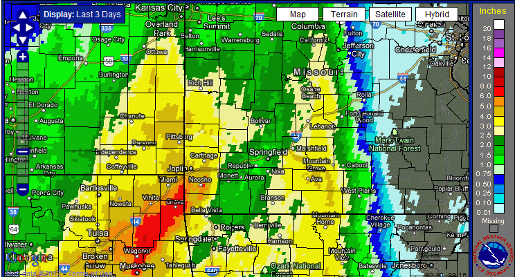
ANDERSON..................5.35 INCHES
TIFF CITY.................5.22 INCHES
NEOSHO....................5.18 INCHES
GAINESVILLE...............5.09 INCHES
CARTHAGE..................4.95 INCHES
MANSFIELD.................4.73 INCHES
WASOLA 5N.................4.68 INCHES
HARTVILLE.................4.44 INCHES
BAXTER SPRINGS KS.........4.39 INCHES
PITTSBURG KS..............4.35 INCHES
JOPLIN....................4.31 INCHES
DORA 2.6 NNW..............4.26 INCHES
HAZELGREEN 1N.............4.14 INCHES
IBERIA....................4.03 INCHES
GIRARD KS.................3.80 INCHES
AVA 6W....................3.68 INCHES
LAMAR.....................3.50 INCHES
PINEVILLE...7SW...........3.47 INCHES
TABLE ROCK DAM............3.20 INCHES
APPLETON CITY.............3.10 INCHES
BRANSON...................3.00 INCHES
MILLER....................2.48 INCHES
MOUNT VERNON..............2.41 INCHES
FORT LEONARD WOOD.........2.19 INCHES
ASH GROVE.................2.07 INCHES
SPRINGFIELD...............1.87 INCHES
WEST PLAINS...............1.29 INCHES
Current Hazards
Experimental Graphical Hazardous Weather Outlook
Submit a storm report
Local Storm Reports
Current Conditions
Observations
Lake Levels
Snowfall Analysis
Road Conditions
Satellite
CoCoRaHS
Graphical Conditions
Precip. Analysis
Forecasts
Forecast Discussion
Fire Weather
Aviation
GIS Forecast Maps
Activity Planner
Severe Weather
Winter Weather
Hurricanes
FAA Center Weather
Space Weather
Climatology
Records and Normals
Monthly Climate Summary
Local
National
Drought
Climate Science
Astronomical Data
US Dept of Commerce
National Oceanic and Atmospheric Administration
National Weather Service
Springfield, MO
Springfield-Branson National Airport
5805 West Highway EE
Springfield, MO 65802-8430
Business: 417-863-8028 Recording: 417-869-4491
Comments? Questions? Please Contact Us.


 Weather Story
 Weather Map
 Local Radar