 |
Winter Storm - February 20th-21st, 2013National Weather Service, Springfield, MO |
 |
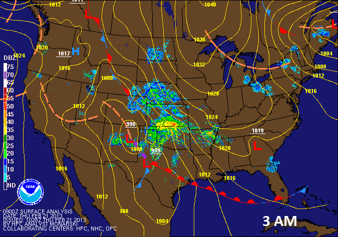
A strong storm system affected much of the central U.S. including the Missouri Ozarks and extreme southeast Kansas from the evening hours on February 20th through much of the day on February 21st. Blizzard conditions affected parts of the Plains in Kansas into northwest Missouri, while across the Missouri Ozarks and southeast Kansas, a wide variety of winter weather occurred. Much of the area began with some light snow and changed over to a mix of sleet and freezing rain as warmer air moved in above the surface. Elevated instability led to numerous embedded thunderstorms which produced heavier rounds of sleet and freezing rain across the area. Across the Missouri Ozarks and southeast Kansas, 1-2 inches of a sleet and snow mix were common along with a quarter to half inch of ice. Further north across portions of west central and Central Missouri, snow was more common and 3 to 5 inches of snow occurred there.
For more information on this storm system, click on one of the links in the menu system above.
A strong dynamic storm system affected the Missouri Ozarks into southeast Kansas mainly during the overnight hours and through the day on February 21st, 2013. This storm system brought a wide variety of winter weather including thunder, freezing rain, sleet and snow to the region.
Dry and cold antecedent conditions led to a later onset of precipitation in the Ozarks which began as snowfall.
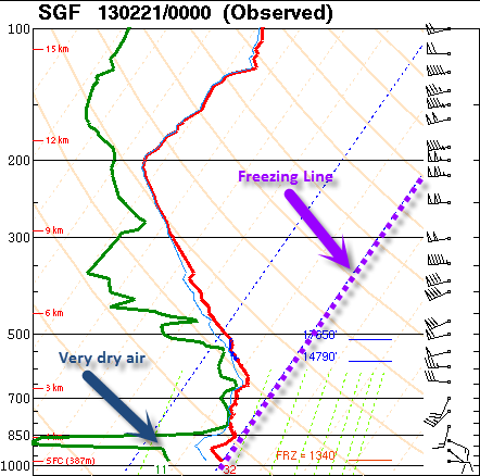
From the 6 pm sounding above, you can see the very dry air (green is the dew point, red is the temperature) in the lower levels that had to moisten up before precipitation would reach the ground. The initial precipitation falling was evaporating in this dry layer but also cooling the air in this column via a process called evaporative cooling.
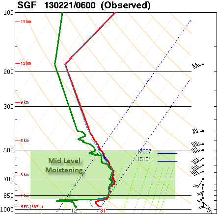
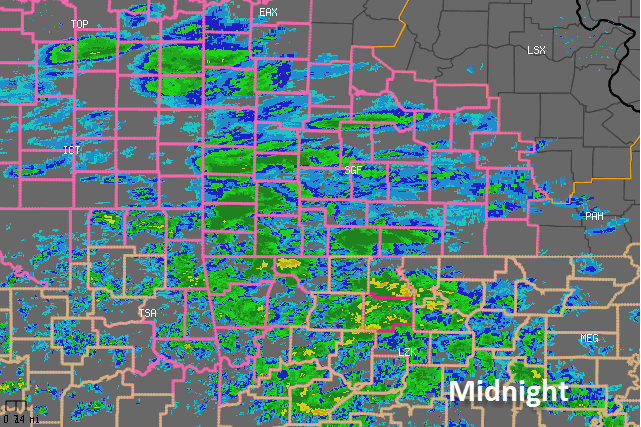
By the midnight sounding (above), you can see the mid levels of the atmosphere had moistened up quite a bit but it was still pretty dry (although moistening) in the lower levels.
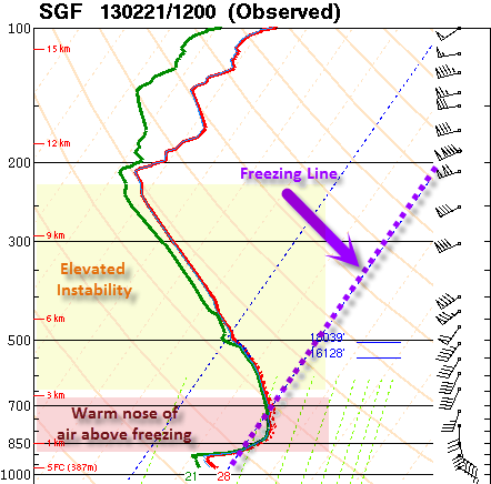
There is a lot going on here in the final 6 am sounding shown above. First of all, notice that the low levels continued to moisten overnight. Warmer air above the surface was advected in from the strong south to southwest winds with temperatures up to 4 degrees Celsius (39 deg F) within the warm nose. The helped to melt the snow as it was falling from above and then fall back to the below freezing temperatures at the surface for freezing rain. There was also enough elevated instability above the warm nose of air to promote thunderstorm development within the precipitation. Sleet became heavy at times during the bouts of thunder during the day.
Eventually during the afternoon, drier air in the mid and upper levels of the atmosphere worked into the area from the southwest and helped push the bulk of the precipitation to the east. Some moisture wrapping around the low brought some freezing drizzle to the area during the evening into parts of the overnight hours of the 22nd.
Below is a radar composite loop from the Springfield radar each hour from Midnight through 9 pm on Feb 21st 2013.
This product is an objective analysis of NWS Cooperative Observer Program (COOP) and Community Collaborative Rain, Hail and Snow Network (CoCoRaHS) snowfall reports. CoCoRaHS data is from non-NWS sources and may have not been fully quality controlled.
THE TOTALS BELOW ARE SEPARATED INTO SNOW...AND ICE AND SLEET
CATEGORIES...THEN BY AMOUNT...AND ARE NOT NECESSARILY THE
FINAL AMOUNT FOR EACH LOCATION.
SNOW REPORTS LISTED BY AMOUNT
INCHES LOCATION ST COUNTY TIME
------ ----------------------- -- -------------- -------
5.00 VERSAILLES MO MORGAN 0920 PM
STORM TOTAL. COUNTY DISPATCH ALSO REPORTED 4
TO 5 INCHES OF SNOW. A QUARTER INCH OF ICE
ALSO REPORTED.
3.00 APPLETON CITY MO ST. CLAIR 1033 AM
THREE INCHES OF SNOW AND SLEET ON THE GROUND.
2.50 WARSAW MO BENTON 1020 AM
TWO TO THREE INCHES OF SNOW ON THE GROUND
WITH SOME SLEET MIXED IN.
1.50 FORT SCOTT KS BOURBON 0910 AM
ADDITIONAL 0.60 INCHES OF SLEET. CURRENTLY
RAINING THOUGH.
0.50 10 W VICHY MO MARIES 1042 AM
ONE HALF INCH OF SNOW AND SLEET REPORTED.
SLEET AND FREEZING RAIN REPORTS LISTED BY AMOUNT
INCHES LOCATION ST COUNTY TIME
------ ----------------------- -- -------------- -------
3.00 FORT SCOTT KS BOURBON 1013 AM
THREE INCHES OF SLEET ON THE GROUND. SOME
SNOW MIXED IN.
3.00 VIENNA MO MARIES 0136 PM
2.50 MARSHFIELD MO WEBSTER 0329 PM
SLEET THIS MORNING ACCUMULATED TO AROUND 2
INCHES IN MARSHFIELD AND AS MUCH 2.5 INCHES
IN SOME PARTS OF THE COUNTY.
2.00 GRAVOIS MILLS MO MORGAN 1001 AM
TWO INCHES OF SLEET ON THE GROUND. SMALL
AMOUNT OF SNOW MIXED IN.
2.00 GRAVOIS MILLS MO MORGAN 1005 AM
TWO INCHES OF SLEET ACCUMULATED ON THE
GROUND.
2.00 DIXON MO PULASKI 1052 AM
TWO INCHES OF SLEET ON THE GROUND. SOME SNOW
MIXED IN.
2.00 CAMDENTON MO CAMDEN 1120 AM
TWO INCHES OF SLEET ON THE GROUND.
2.00 BOLIVAR MO POLK 0113 PM
2.00 SALEM MO DENT 0241 PM
1.5 TO 2 INCHES ACCUMULATION.
2.00 NIXA MO CHRISTIAN 0324 PM
HEAVY PRECIPITATION OCCURRED THIS MORNING.
ALSO A TENTH TO A QUARTER INCH OF ICE.
1.75 WALKER MO VERNON 0942 AM
ONE AND THREE QUARTERS INCH ACCUMULATION OF
SLEET AND HAIL ON THE GROUND.
1.50 JOPLIN MO JASPER 0908 AM
1.50 CROSS TIMBERS MO HICKORY 1023 AM
THREE QUARTERS OF AN INCH OF SLEET ON THE
GROUND.
1.50 WAYNESVILLE MO PULASKI 1137 AM
ONE AND ONE HALF INCHES OF SLEET ON THE
GROUND.
1.50 JOPLIN MO JASPER 1218 PM
1.50 MOUNT VERNON MO LAWRENCE 0335 PM
AN INCH TO AN INCH AND A HALF OF SLEET.
1.25 ROLLA MO PHELPS 1107 AM
ONE AND ONE QUARTER INCHES OF SLEET. THIN
GLAZE OF FREEZING RAIN ALSO.
1.25 IBERIA MO MILLER 1123 AM
THIN GLAZE OF ICE.
1.25 WAYNESVILLE MO PULASKI 0201 PM
ADDITIONAL 0.25 INCHES SINCE NOON. TOTAL 1.25
INCHES.
1.00 RICHLAND MO PULASKI 1010 AM
ONE INCH OF SLEET ON THE GROUND.
1.00 5 N SENECA MO NEWTON 1016 AM
ONE INCH OF SLEET WITH A GLAZE OF ICE.
1.00 LAMAR MO BARTON 1043 AM
ONE INCH OF SLEET ON THE GROUND.
1.00 3 NE HALLTOWN MO GREENE 1208 PM
MEASURED ONE INCH OF SLEET ACCUMULATION AND
ONE EIGHTH INCH OF ICE ACCRETION.
1.00 WAYNESVILLE MO PULASKI 1215 PM
ONE INCH OF SLEET AND ONE EIGHTH TO ONE
QUARTER INCH OF FREEZING RAIN REPORTED.
1.00 6 NE WILLARD MO GREENE 0100 PM
ALSO ABOUT A TENTH TO TWO TENTHS OF AN INCH
OF ICE.
1.00 EMINENCE MO SHANNON 0230 PM
COMBINED SLEET AND ICE ACCUMULATION.
1.00 AVA MO DOUGLAS 0231 PM
ALSO...0.1 INCH OF FREEZING RAIN ACCUMULATION
ON EXPOSED OBJECTS.
1.00 WINONA MO SHANNON 0235 PM
COMBINED HALF INCH TO AN INCH OF SLEET AN
ICE. MOSTLY SLEET.
1.00 BRANSON MO TANEY 0255 PM
RANGED FROM AN A HALF INCH IN THE SOUTHERN
PART OF TANEY COUNTY TO AN INCH IN THE
NORTHERN PART OF THE COUNTY. A TRACE OF ICE
ACCUMULATION.
1.00 MARSHFIELD MO WEBSTER 0330 PM
ONE HALF INCH TO ONE INCH OF SLEET
ACCUMULATION COUNTY WIDE.
1.00 6 S SPRINGFIELD MO GREENE 0347 PM
ONE INCH OF SLEET AND A QUARTER INCH OF ICE
GLAZED ON TREE LIMBS.
0.75 SARCOXIE MO JASPER 0732 AM
0.75 BUFFALO MO DALLAS 0851 AM
THREE QUARTERS OF AN INCH OF SLEET AND HAIL
ON THE GROUND. ONE EIGTH INCH OF ICE
ACCUMULATION.
0.75 PITTSBURG KS CRAWFORD 0853 AM
0.75 CASSVILLE MO BARRY 0313 PM
SLEET ACCUMULATION OF A HALF INCH TO THREE
QUARTERS OF AN INCH. JUST A GLAZE IN THE
TREES.
0.70 HERMITAGE MO HICKORY 0716 AM
THREE QUARTERS OF AN INCH OF SLEET REPORTED
ON THE GROUND.
0.70 6 WSW JOPLIN MO NEWTON 0800 AM
THREE QUARTERS OF AN INCH OF SLEET REPORTED
ON THE GROUND NEAR THE TRI STATE LINE.
0.70 BUFFALO MO DALLAS 0851 AM
THREE QUARTERS OF AN INCH OF HAIL AND SLEET
ON THE GROUD. ONE EIGHT INCH OF ICE
ACCUMUATION.
0.60 2 WNW SPRINGFIELD MO GREENE 1120 AM
MEASURED 0.6 INCHES OF SLEET AND SMALL HAIL
AT NWS OFFICE.
0.50 OSCEOLA MO ST. CLAIR 0707 AM
HALF INCH OF SLEET REPORTED ON THE GROUD.
0.50 BOLIVAR MO POLK 0742 AM
HALF INCH OF SLEET REPORTED.
0.50 10 W SPRINGFIELD MO GREENE 0946 AM
ONE HALF INCH OF SLEET ACCUMULATION. ONE
EIGHTH INCH OF ICE ACCUMULATION.
0.50 WEST PLAINS MO HOWELL 0153 PM
0.50 GAINESVILLE MO OZARK 0255 PM
ESTIMATED A COMBINED QUARTER TO HALF INCH OF
SLEET AND ICE.
0.33 1 NE BATTLEFIELD MO GREENE 0809 AM
SLEET FELL IN 90 MINUTES. ADDITIONALLY ONE
TENTH INCH OF FREEZING RAIN ACCUMULATION.
0.25 JOPLIN MO JASPER 0634 AM
MEASURED AT THE JOPLIN AIRPORT.
0.25 CLEVER MO CHRISTIAN 0800 AM
0.25 LAMPE MO STONE 1024 AM
ONE QUARTER INCH OF SLEET ON THE GROUND AND A
GLAZE OF ICE.
0.25 THAYER MO OREGON 0200 PM
REPORT RELAYED VIA LOCAL NEWSPAPER. QUARTER
INCH OF ICE. SOME WEAK SMALL TREE LIMBS DOWN.
0.25 WILLOW SPRINGS MO HOWELL 0215 PM
ALSO AN INCH OF SLEET.
0.25 ALTON MO OREGON 0230 PM
SOME LIMBS DOWN ONTO POWERLINES CAUSING FIRES
IN THE COUNTY.
0.25 PINEVILLE MO MCDONALD 0300 PM
MOST OF THE SLEET HAS MELTED.
0.25 MARSHFIELD MO WEBSTER 0330 PM
0.20 PITTSBURG MO HICKORY 0700 AM
0.10 FORT SCOTT KS BOURBON 0624 AM
TENTH INCH OF SLEET ALONG WITH 1.25 INCHES OF
SNOW. PRECIPITATION BECOMING FREEZING RAIN
RESULTING IN AN ADDITIONAL GLAZE OF ICE.
0.10 SALEM MO DENT 1041 AM
FREEZING RAIN ACCUMULATION ON ROADS, POWER
LINES AND TREES. MIXING WITH SLEET NOW.


 Weather Story
 Weather Map
 Local Radar