Springfield, MO
Weather Forecast Office
Overview
|
Pockets of sleet and snow began to overspread southeastern Kansas and the Missouri Ozarks Wednesday evening as an upper level disturbance approached from the northwest. Some locations across primarily southwestern Missouri saw sleet accumulations of up to two-tenths of an inch Wednesday evening. A narrow band of heavier snow then developed across portions of the eastern Missouri Ozarks late Wednesday night with the snow quickly coming to an end by early Thursday morning. 1-3" of snow fell in a corridor from around Lebanon and Hartville, east into the Salem area. |
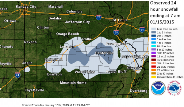 Snowfall Amounts |
Radar:
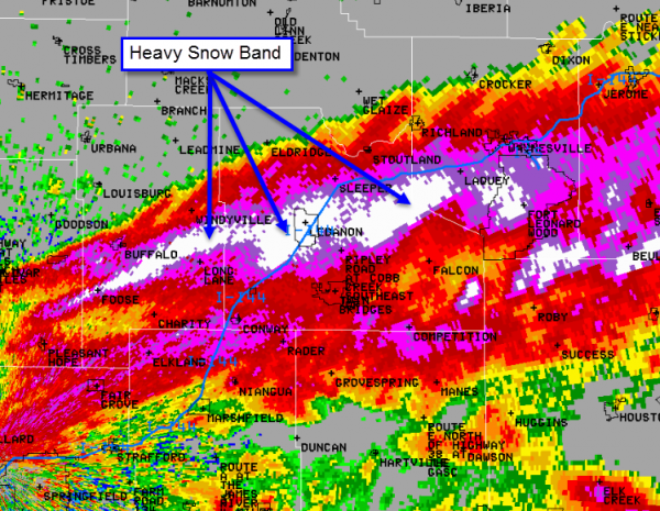
Animated radar loop from 145 AM through 645 AM which shows the narrow band of snow that developed across eastern portions of the Missouri Ozarks. The purple and especially the white colors indicate areas of heavy snowfall on radar. There was a thin layer of dry air in place near the surface as this snow band developed, so it took about a half hour for snow to saturate the lower atmosphere and begin reaching the ground even beneath these heavier radar echoes. The weaker bands of snow (yellows and oranges) took even longer to saturate lower portions of the atmosphere. Some locations never did receive any snowfall below these weaker radar echoes.

 |
Media use of NWS Web News Stories is encouraged! Please acknowledge the NWS as the source of any news information accessed from this site. |
|
Current Hazards
Experimental Graphical Hazardous Weather Outlook
Submit a storm report
Local Storm Reports
Current Conditions
Observations
Lake Levels
Snowfall Analysis
Road Conditions
Satellite
CoCoRaHS
Graphical Conditions
Precip. Analysis
Forecasts
Forecast Discussion
Fire Weather
Aviation
GIS Forecast Maps
Activity Planner
Severe Weather
Winter Weather
Hurricanes
FAA Center Weather
Space Weather
Climatology
Records and Normals
Monthly Climate Summary
Local
National
Drought
Climate Science
Astronomical Data
US Dept of Commerce
National Oceanic and Atmospheric Administration
National Weather Service
Springfield, MO
Springfield-Branson National Airport
5805 West Highway EE
Springfield, MO 65802-8430
Business: 417-863-8028 Recording: 417-869-4491
Comments? Questions? Please Contact Us.


 Weather Story
 Weather Map
 Local Radar