Springfield, MO
Weather Forecast Office
Overview
|
A mixture of freezing rain and sleet developed during the early to mid-morning hours of March 4th, 2015. Sleet accumulations were quite significant across portions of southern Missouri and ranged from one-quarter to near one-half of an inch. A few locations in far south-central Missouri had sleet accumulations near three-quarters of an inch. Freezing rain accumulations were light and generally amounted to just a light glaze. The mixed precipitation then changed to snow from northwest to southeast across the region from mid-morning through early afternoon. The snow became heavy at times across south-central Missouri during the afternoon and early evening hours. Snow accumulations ranged from 4 to 7 inches in far south central Missouri with a report of 8 inches at Koshkonong in Oregon County. Accumulations were lighter farther northwest ranging from 1 to 3 inches along and south of the I-44 corridor to just a dusting from southeastern Kansas into central Missouri. |
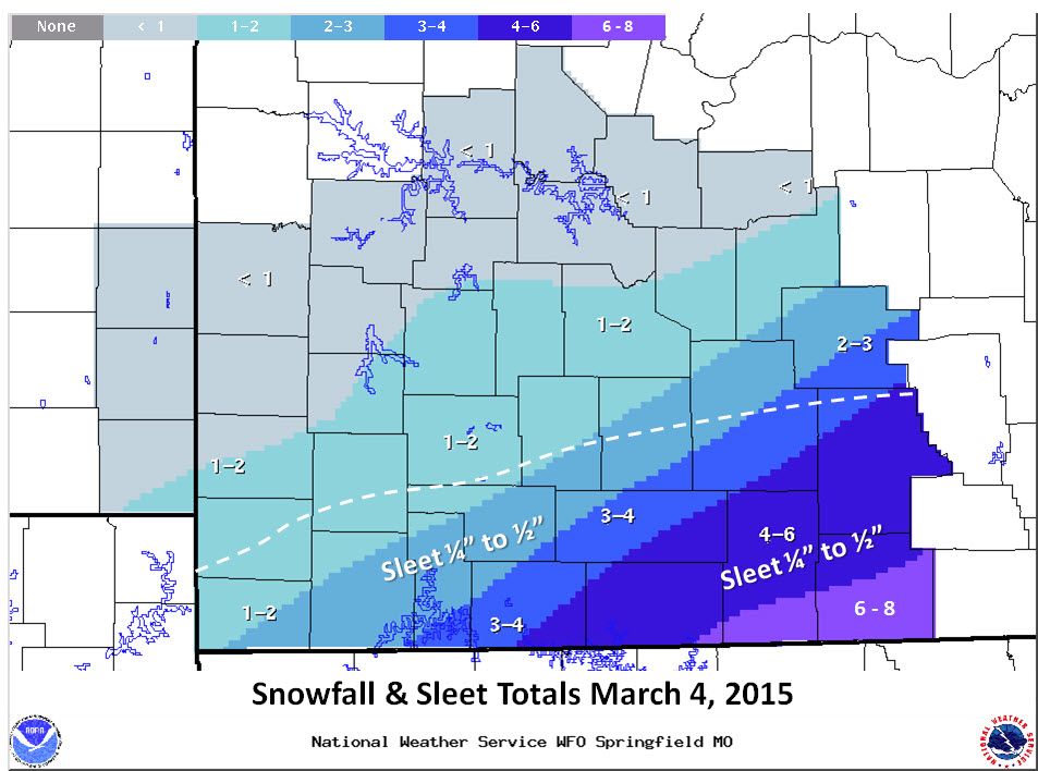 Snowfall and Sleet Totals |
 |
Media use of NWS Web News Stories is encouraged! Please acknowledge the NWS as the source of any news information accessed from this site. |
|
Current Hazards
Experimental Graphical Hazardous Weather Outlook
Submit a storm report
Local Storm Reports
Current Conditions
Observations
Lake Levels
Snowfall Analysis
Road Conditions
Satellite
CoCoRaHS
Graphical Conditions
Precip. Analysis
Forecasts
Forecast Discussion
Fire Weather
Aviation
GIS Forecast Maps
Activity Planner
Severe Weather
Winter Weather
Hurricanes
FAA Center Weather
Space Weather
Climatology
Records and Normals
Monthly Climate Summary
Local
National
Drought
Climate Science
Astronomical Data
US Dept of Commerce
National Oceanic and Atmospheric Administration
National Weather Service
Springfield, MO
Springfield-Branson National Airport
5805 West Highway EE
Springfield, MO 65802-8430
Business: 417-863-8028 Recording: 417-869-4491
Comments? Questions? Please Contact Us.


 Weather Story
 Weather Map
 Local Radar