Springfield, MO
Weather Forecast Office
Overview
|
Surface low pressure to our south and an upper level system combined to bring a mix of Wintry weather across the Ozarks. Most of the area received rainfall throughout the evening of the 22nd, with a period of freezing rain prior to the changeover to all snow after midnight. The primary snow band set up along the Interstate 44 corridor from southwest into east central Missouri where 1 to 2.5 inches of snowfall occurred. The warm ground kept the ice from glazing on the roadways, but a glazing of ice did occur in some locations on elevated surfaces. |
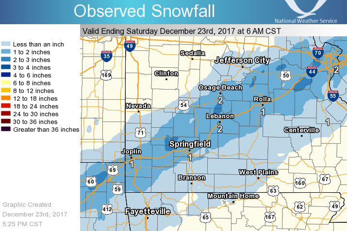 Snowfall for Dec 22nd-23rd, 2017 |
Rain/Snow/Ice
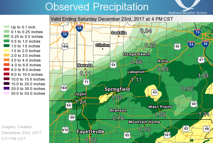
Much needed rainfall occurred ahead of the snow across the area. Heaviest rain occurred along the I44 corridor, where over an inch of rain fell.
Rainfall eventually changed over to all snow after midnight from west to east with the most snow occurring along the I44 corridor. A band of 1 to 2.5 inches of snow occurred there.
 |
Media use of NWS Web News Stories is encouraged! Please acknowledge the NWS as the source of any news information accessed from this site. |
|
Current Hazards
Experimental Graphical Hazardous Weather Outlook
Submit a storm report
Local Storm Reports
Current Conditions
Observations
Lake Levels
Snowfall Analysis
Road Conditions
Satellite
CoCoRaHS
Graphical Conditions
Precip. Analysis
Forecasts
Forecast Discussion
Fire Weather
Aviation
GIS Forecast Maps
Activity Planner
Severe Weather
Winter Weather
Hurricanes
FAA Center Weather
Space Weather
Climatology
Records and Normals
Monthly Climate Summary
Local
National
Drought
Climate Science
Astronomical Data
US Dept of Commerce
National Oceanic and Atmospheric Administration
National Weather Service
Springfield, MO
Springfield-Branson National Airport
5805 West Highway EE
Springfield, MO 65802-8430
Business: 417-863-8028 Recording: 417-869-4491
Comments? Questions? Please Contact Us.


 Weather Story
 Weather Map
 Local Radar