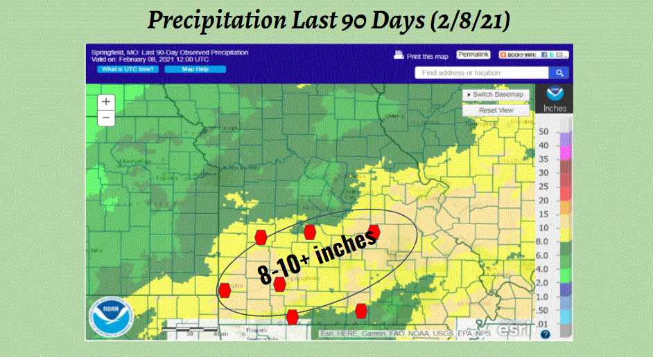
This Spring Flood Outlook is for the larger river systems in the National Weather Service Springfield Missouri Hydrologic Service Area (HSA). This includes the Spring, Osage, Gasconade, James, Jacks Fork, Elk and North Fork White Basins. The chances for river flooding across the Missouri Ozarks and southeast Kansas will be near normal this Spring, and mainly affected by heavy rainfall from thunderstorm activity. Details on the chances for minor, moderate and major flooding for area river forecast points will be given below.Summary of Recent Conditions: It has been a wetter than normal late fall and winter along and north of a line from Cassville to Lebanon to Rolla, where precipitation accumulations averaged between 100% and 150% of normal for the past 90 days. To the south of this line, precipitation accumulations have been below normal, with these locations receiving between 50% and 75% of their normal rainfall.
Soil moisture is near normal over most of the region, except over extreme southwest Missouri and southeast Kansas, where soil moisture is slightly above normal. Due to heavy rainfall received in late January, area streams and larger rivers currently have above normal to much above normal streamflows. Drought conditions are not occurring over the Missouri Ozarks and southeast Kansas and are not expected to develop over the next three months. Temperature and Precipitation Outlooks: The 8-14 Day Outlook and the 30-Day Outlook issued by the NWS Climate Prediction Center indicates above normal chances for below normal temperatures and above normal rainfall. The 90-Day Outlook indicates increasing chances for above normal temperatures and equal chances for above, below and normal precipitation. River Flood Potential Outlooks: Far Southwest Missouri and Extreme Southeast Kansas -Spring River, Elk River and Shoal Creek: There is a near normal chance for river flooding this Spring based on current conditions and seasonal outlooks. River flooding is typically driven by thunderstorm activity. No flooding is occurring in this area and no flooding is expected for the next week. It has been a relatively wet winter so far for Southwest Missouri, with precipitation during the last 60 days running above average. Much of southwestern Missouri received 110% to 150% of their normal precipitation during the same period. Soil moisture in southwestern Missouri is currently above normal (greater than the 70th percentile). Streamflows are averaging near to above normal for this time of year. Streamflows with respect to median flow for selected river forecast points are given below. Spring River Carthage, MO 270% Spring River Waco, MO 206% Shoal Creek Joplin, MO 245% Elk River Tiff City, MO 154% The table below shows probabilities for minor, moderate and major flooding at river forecast points across far southwest Missouri and southeast Kansas through late April. These are not extreme conditions for this region and reflect a near normal potential for flooding. Location % Probability % Probability % Probability Minor Flooding Moderate Flooding Major Flooding Spring River Carthage, MO 40 18 Not Expected Waco, MO 44 Not Expected Not Expected Baxter Springs, KS 47 16 5 Elk River Tiff City, MO 38 7 Not Expected Shoal Creek Joplin, MO 15 7 Not Expected Southeast Kansas, West Central Missouri, and Central Missouri- Osage, Little Osage, Marmaton, Sac, Big Piney and Gasconade River and Roubidoux Creek. There is a near normal chance for river flooding this Spring based on current conditions and seasonal outlooks. River flooding is typically driven by thunderstorm activity. Normal to slightly above normal precipitation has occurred across west central Missouri and southeast Kansas over the last 60 days. However, streamflows is above normal due to heavy rainfall received in late January. While river flooding has already occurred in this area, there is currently no flooding is occurring in the Osage, Gasconade or Sac basins at this time and no flooding is expected for the next several days. Observed daily streamflows as a percent of median for selected river forecast points in the Osage, Gasconade and Sac Basins are given below. Little Osage River Fulton, KS 163% Little Osage River Horton, MO 96% Marmaton River Fort Scott, KS 150% Osage River Taberville, MO 84% Big Piney River Fort Leonard Wood, MO 169% Gasconade River Hazelgreen, MO 171% Gasconade River Jerome, MO 178% Sac River Caplinger Mills, MO 339% Larger lakes along and near the Osage River have between 97% and 100% of their flood pool storage available to collect water from Spring rainfall. Percentages for each lake are given below. Stockton 97% Pomme de Terre 98% Truman 99% Lake of the Ozarks 100% The table below shows probabilities for minor, moderate and major flooding at river forecast points across west central Missouri and southeast Kansas through late April. These are not extreme conditions for this region and reflect a near normal potential for flooding. Location % Probability % Probability % Probability Minor Flooding Moderate Flooding Major Flooding Little Osage River Fulton, KS 66 52 Not Expected Horton, MO 92 40 Not Expected Marmaton River Fort Scott, KS 45 15 6 Nevada, MO 82 45 10 Osage River Schell City, MO 60 22 Not Expected Taberville, MO 62 6 Not Expected Sac River Caplinger Mills, MO 68 55 6 Gasconade River Hazelgreen, MO 32 17 5 Jerome, MO 49 22 5 Roubidoux Creek Waynesville, MO 48 5 Not Expected Big Piney River Fort Leonard Wood, MO 73 38 5 Southwest and south central Missouri - James, Jacks Fork, and North Fork White Rivers. There is a near normal chance for river flooding this Spring based on current conditions and seasonal outlooks. River flooding is typically driven by thunderstorm activity. Normal to slightly below normal precipitation has occurred over the past 60 days. Soil moisture content and streamflow conditions are above seasonal levels due to rainfall received in late January. While river flooding has already occurred in this area, there currently is no flooding occurring at this time, and no flooding is expected for the next several days. Observed daily streamflows as a percent of median are given below. James River Galena MO 139% North Fork White River Tecumseh MO 143% Jacks Fork River Alley Spring 105% Jacks Fork River Eminence 163% Most lakes along and near the White River near the Missouri - Arkansas border will have nearly all of their flood pool storage available for collecting Spring rainfall. Percentages of available flood control storage for the White River Reservoirs are given below. Beaver 99% Table Rock 100% Bull Shoals 100% Norfork 99% The table below shows probabilities for minor, moderate and major flooding at river forecast points across south central and southwest Missouri through late April. These are not extreme conditions for this region and reflect a near normal potential for flooding. Location % Probability % Probability % Probability Minor Flooding Moderate Flooding Major Flooding Jacks Fork River Alley Spring 30 9 Not Expected Eminence 9 Not Expected Not Expected James River Galena, MO 48 12 Not Expected North Fork Tecumseh 15 Not Expected Not Expected These long-range probabilistic outlooks contain forecast values that are calculated using multiple season scenarios from 30 or more years of climatological data...including current conditions of the river...soil moisture...snow cover...and 30 to 90 day long-range outlooks of temperature and precipitation. By providing a range of probabilities...the level of risk associated with long-range planning decisions can be determined. These probabilistic forecasts are part of the National Weather Service`s Advanced Hydrologic Prediction Service. Visit our web site weather.gov/sgf under the rivers and lakes tab and long range risk tab for more weather information. The next outlook will be issued on Thursday February 25th.


 Weather Story
 Weather Map
 Local Radar