
Tropical system in the Gulf expected to gradually strengthen the next couple of days off the Florida Panhandle and Alabama coasts. Instances of flash flooding will be possible through Thursday along the eastern and central Gulf Coast. Severe thunderstorms will develop and move along a cold front crossing the Upper Midwest, and through the Ohio Valley/Mid-Atlantic on Tuesday. Read More >
Severe weather affected the Heartland and Big Country areas of West Central Texas, between 7 PM and Midnight on May 25.
In the Heartland area, a supercell severe thunderstorm moved to the southwest across southern Brown and much of San Saba Counties. Strong outflow winds from the storm downed trees and power lines in Brownwood and Early. Strong winds (estimated at 65 mph) and quarter-sized hail were reported in Zephyr.
After intensifying in northern San Saba County, the storm produced very large hail and destructive winds which caused significant damage in Richland Springs. A damage survey from the National Weather Service in San Angelo was conducted on May 26 in San Saba County. From this survey, the damage path was 9 miles in length, and 1.5 miles wide. The damage path extended from 7 miles northeast of Richland Springs, to 2 miles southwest of Richland Springs. The survey found evidence of damaging straight-line winds of 80-85 mph, along with softball-sized hail in Richland Springs.
Radar images of this supercell storm are shown in Figures 1 and 2 below. These radar images, from Dyess AFB, show the storm in northern San Saba County. The radar beam intersected the storm approximately 8,000 ft. above the ground.
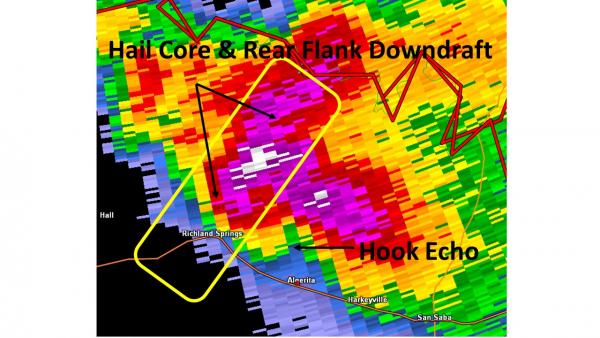
Figure 1: Radar Image (reflectivity) at 845 PM CDT from Dyess AFB Radar, at 0.5 degrees elevation.
Rainfall intensity is measured in the radar reflectivity image in Figure 1. The area in white is where the heaviest rainfall, and likely location of the largest hail, appear in this image. With this supercell storm, the Rear Flank Downdraft and hail core moved to the southwest across the town of Richland Springs. The Hook Echo shows the location of where tornado development was possible, at the time of this radar image.
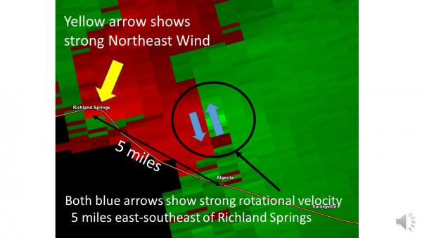
Figure 2: Radar Image (velocity) at 845 PM CDT from Dyess AFB Radar, at 0.5 degrees elevation.
In Figure 2, green shading shows where winds were blowing toward the radar, while red shading shows where winds were blowing away from the radar. The brightness of the red and green color shading are related to the strength of the winds. The encircled area shows where strong rotational velocity was occurring with this storm. Strong winds from the northeast, which affected Richland Springs, are denoted by the yellow arrow. These winds were associated with with the Rear Flank Downdraft, in the Figure 1 reflectivity image.
Photos of the storm damage, from the Richland Springs area, are shown in Figures 3-6 below.

Figure 3: Hail damage to a vehicle.

Figure 4: Hail damage to a vehicle. The leaves were stripped from nearby trees.

Figure 5: Damage to a home from wind-driven hail.
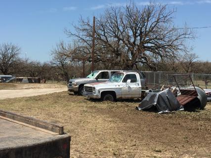
Figure 6: Hail and wind damage. The leaves were stripped from nearby trees.
An additional storm developed in southwestern San Saba County, and became severe as it moved southwest into Mason County. This storm dropped quarter-sized hail 4 miles east-southeast of Mason.
Farther to the north, other scattered thunderstorms with strong, gusty winds moved south across parts of the Big Country. A semi-trailer was blown onto vehicles, from strong winds in the Clyde area.
A few wind reports with the Big Country storms are included in the table below.
| Location | County | Peak Wind Speed (mph) | Source | Time (CDT) |
| Haskell 1 NW | Haskell | 56 | Mesonet | 845 PM |
| Stamford 5 ESE | Jones | 66 | Mesonet | 903 PM |
| Clyde 2 WNW | Callahan | 54 | Mesonet | 1015 PM |
Figure 7 shows a radar loop of the supercell storm which moved southwest across Brown and San Saba Counties, along with the storms which moved south across the Big Country area.
Figure 7: Animated Loop of Radar Imagery on May 25 (between 7 PM and 11 PM).
A total of 10 severe weather reports were received for the storms on May 25.

