
A heat wave over the Southwest will intensify this week, peaking and expanding into the Intermountain West and northern High Plains this weekend. Critical to extremely critical fire weather conditions are forecast from the Northwest and the northern Great Basin this weekend. Particularly Dangerous Situation Red Flag Warnings have been issued. Read More >
Fire Weather Forecast:
|
816 FNUS55 KTFX 010708 FWFTFX Fire Weather Planning Forecast for North-Central Montana National Weather Service Great Falls MT 108 AM MDT Sat Aug 1 2026 ...RED FLAG WARNING IN EFFECT FROM NOON TODAY TO 9 PM MDT SUNDAY... .DISCUSSION... Critical fire weather conditions are forecast this weekend across all fire weather districts. Gusty winds developing this afternoon ahead of a dry cold front will combine with relative humidities approaching single digits to result in critical fire weather conditions in most areas. Winds shift to a more northwesterly direction this afternoon and evening behind the cold front. While gusty winds diminish somewhat out over the plains tonight, strong winds will develop along the Rocky Mountain Front this evening, slowly expanding over the plains through the night and into the day Sunday. Overnight humidity recovery is forecast to be nearly non-existent where these winds are persistent overnight near the Rocky Mountain Front. Although cooler temperatures will be moving in behind the cold front for Sunday, very low relative humidity will persist (Approaching single digits once again). Combine this with forecast breezy winds, and critical fire weather conditions will be around once again for Sunday. Winds diminish Sunday evening, leading to a less active beginning to the week from a fire weather perspective. After a briefly cool stretch Monday and Tuesday, temperatures trend warmer once again mid- week, with minimum relative humidity dropping into the teens once again. -AM MTZ112-012215- Eastern Glacier/Toole/Central/Eastern Pondera/Liberty- 108 AM MDT Sat Aug 1 2026 ...RED FLAG WARNING IN EFFECT FROM NOON TODAY TO 9 PM MDT SUNDAY... .TODAY... * Sky/Weather...........Mostly sunny. Areas of smoke in the morning, then patchy smoke in the afternoon. * Chance Lightning.......0 percent. * Max Temperature.......93-103...81-91 higher elevations. 24 hr trend......6 degrees up. * Min Humidity..........10-15 percent. 24 hr trend......2 percent down. * Wind (20 FT). Lower Elevations...South winds 15 to 20 mph shifting to the southwest in the afternoon. Ridges.............South winds 15 to 20 mph. * Mixing Height.........500-1500 ft agl increasing to 11500-13000 ft agl. * Transport Winds.......South 20 to 25 mph increasing to southwest around 35 mph in the afternoon. * CWR...................0 percent. .TONIGHT... * Sky/Weather...........Partly cloudy. Patchy smoke through the night. * Chance Lightning.......0 percent. * Min Temperature.......53-61. 24 hr trend......2 degrees up...6 degrees down higher elevations. * Max Humidity..........40-49 percent. 24 hr trend......7 percent down...2 percent up higher elevations. * Wind (20 FT). Lower Elevations...Very windy. West winds around 40 mph. Ridges.............Very windy. West winds around 40 mph. * Mixing Height.........11500 ft agl decreasing to 500-1000 ft agl. * Transport Winds.......West around 50 mph. * CWR...................0 percent. .SUNDAY... * Sky/Weather...........Sunny. Areas of smoke in the morning, then patchy smoke in the afternoon. * Chance Lightning.......0 percent. * Max Temperature.......71-81...61-71 higher elevations. 24 hr trend......22 degrees down. * Min Humidity..........13-19 percent. 24 hr trend......3 percent up. * Wind (20 FT). Lower Elevations...Windy. West winds 25 to 30 mph. Ridges.............Windy. West winds around 30 mph decreasing to 20 to 25 mph in the afternoon. * Mixing Height.........500-1500 ft agl increasing to 9500 ft agl. * Transport Winds.......West around 45 mph decreasing to around 35 mph in the afternoon. * CWR...................0 percent. .FORECAST DAYS 3 THROUGH 7...... .MONDAY...Windy. Partly cloudy. Lows in the mid 40s. Highs in the upper 60s. Northwest winds around 25 mph. .TUESDAY...Mostly clear. Lows in the mid 40s. Highs in the mid 70s. Southwest winds 15 to 20 mph. .WEDNESDAY...Mostly clear. Lows around 50. Highs in the mid 80s. Southwest winds 10 to 15 mph. .THURSDAY...Mostly clear. Lows in the lower 50s. Highs in the upper 80s. .FRIDAY...Mostly clear. Lows in the mid 50s. Highs in the mid 80s. $$ MTZ113-012215- Hill and Blaine Counties- 108 AM MDT Sat Aug 1 2026 ...RED FLAG WARNING IN EFFECT FROM NOON TODAY TO 9 PM MDT SUNDAY... .TODAY... * Sky/Weather...........Sunny. Patchy smoke. * Chance Lightning.......0 percent. * Max Temperature.......100-106...90-96 higher elevations. 24 hr trend......11 degrees up. * Min Humidity..........8-13 percent. 24 hr trend......4 percent down. * Wind (20 FT). Lower Elevations...South winds 10 to 15 mph. Ridges.............South winds 10 to 15 mph. * Mixing Height.........500-2000 ft agl increasing to 12000-13500 ft agl. * Transport Winds.......Southeast 15 to 20 mph increasing to south around 25 mph in the afternoon. * CWR...................0 percent. .TONIGHT... * Sky/Weather...........Partly cloudy. Patchy smoke through the night. * Chance Lightning.......0 percent. * Min Temperature.......60-69. 24 hr trend......4 degrees up. * Max Humidity..........30-40 percent. 24 hr trend......21 percent down...4 percent down higher elevations. * Wind (20 FT). Lower Elevations...Windy. West winds 20 to 25 mph increasing to around 30 mph after midnight. Ridges.............Windy. West winds 15 to 20 mph increasing to northwest around 25 mph after midnight. * Mixing Height.........13000 ft agl decreasing to 500-1500 ft agl. * Transport Winds.......West around 25 mph increasing to around 35 mph after midnight. * CWR...................0 percent. .SUNDAY... * Sky/Weather...........Sunny. Patchy smoke. * Chance Lightning.......0 percent. * Max Temperature.......81-86...72-77 higher elevations. 24 hr trend......22 degrees down. * Min Humidity..........8-13 percent. 24 hr trend......1 percent up. * Wind (20 FT). Lower Elevations...Windy. West winds 20 to 25 mph. Ridges.............Windy. West winds around 25 mph decreasing to 15 to 20 mph in the afternoon. * Mixing Height.........1000-1500 ft agl increasing to 10500 ft agl. * Transport Winds.......West around 30 mph. * CWR...................0 percent. .FORECAST DAYS 3 THROUGH 7...... .MONDAY...Cooler, windy. Partly cloudy. Lows in the upper 40s. Highs in the upper 60s. Northwest winds around 25 mph. .TUESDAY...Mostly clear. Lows in the mid 40s. Highs in the upper 70s. West winds 20 to 25 mph. .WEDNESDAY...Mostly clear. Lows in the lower 50s. Highs in the upper 80s. South winds 10 to 15 mph. .THURSDAY...Partly cloudy. Lows in the mid 50s. Highs in the lower 90s. .FRIDAY...Mostly clear. Lows in the upper 50s. Highs in the upper 80s. $$ MTZ114-012215- Lewis and Clark National Forest Rocky Mountain District- Rocky Mountain Front- 108 AM MDT Sat Aug 1 2026 ...RED FLAG WARNING IN EFFECT FROM NOON TODAY TO 9 PM MDT SUNDAY... .TODAY... * Sky/Weather...........Mostly sunny. Patchy smoke. * Chance Lightning.......0 percent. * Max Temperature.......93-103...78-88 higher elevations. 24 hr trend......5 degrees up. * Min Humidity..........11-20 percent. 24 hr trend......3 percent down. * Wind (20 FT). Lower Elevations...Southwest winds 15 to 20 mph. Ridges.............Southwest winds 15 to 20 mph. * Mixing Height.........500-2000 ft agl increasing to 12000-12500 ft agl. * Transport Winds.......Southwest 20 to 25 mph increasing to around 35 mph in the afternoon. * CWR...................0 percent. .TONIGHT... * Sky/Weather...........Partly cloudy. Patchy smoke. * Chance Lightning.......0 percent. * Min Temperature.......55-61...47-55 higher elevations. 24 hr trend......3 degrees up...10 degrees down higher elevations. * Max Humidity..........38-48 percent. 24 hr trend......7 percent up...13 percent up higher elevations. * Wind (20 FT). Lower Elevations...Very windy. West winds 35 to 45 mph. Ridges.............Strong winds. West winds 35 to 45 mph. * Mixing Height.........10500 ft agl decreasing to 500-2000 ft agl. * Transport Winds.......West around 55 mph. * CWR...................0 percent. .SUNDAY... * Sky/Weather...........Sunny. Patchy smoke through the day. * Chance Lightning.......0 percent. * Max Temperature.......73-83...58-68 higher elevations. 24 hr trend......19 degrees down. * Min Humidity..........11-17 percent...16-26 percent higher elevations. 24 hr trend......1 percent up. * Wind (20 FT). Lower Elevations...Windy. West winds around 30 mph decreasing to 20 to 25 mph in the afternoon. Ridges.............Very windy. West winds around 40 mph decreasing to around 25 mph in the afternoon. * Mixing Height.........500-1000 ft agl increasing to 7500-9000 ft agl. * Transport Winds.......West around 50 mph decreasing to around 35 mph in the afternoon. * CWR...................0 percent. .FORECAST DAYS 3 THROUGH 7...... .MONDAY...Windy. Mostly clear. Lows in the mid 40s. Highs in the mid 60s. Northwest winds around 25 mph. .TUESDAY...Mostly clear. Lows in the mid 40s. Highs in the mid 70s. East winds 10 to 15 mph. .WEDNESDAY...Mostly clear. Lows in the upper 40s. Highs in the lower 80s. West winds 10 to 15 mph. .THURSDAY...Mostly clear. Lows in the lower 50s. Highs in the mid 80s. .FRIDAY...Mostly clear. Lows in the mid 50s. Highs in the lower 80s. $$ MTZ115-012215- Chouteau and Fergus Counties- 108 AM MDT Sat Aug 1 2026 ...RED FLAG WARNING IN EFFECT FROM NOON TODAY TO 9 PM MDT SUNDAY... .TODAY... * Sky/Weather...........Mostly sunny. Areas of smoke in the morning, then patchy smoke in the afternoon. * Chance Lightning.......0 percent. * Max Temperature.......100-108...93-98 higher elevations. 24 hr trend......9 degrees up. * Min Humidity..........6-11 percent. 24 hr trend......6 percent down. * Wind (20 FT). Lower Elevations...Southeast winds 15 to 20 mph shifting to the southwest in the afternoon. Ridges.............Southeast winds 15 to 20 mph shifting to the southwest in the afternoon. * Mixing Height.........500-2000 ft agl increasing to 14000-14500 ft agl. * Transport Winds.......Southeast 15 to 20 mph increasing to southwest around 30 mph in the afternoon. * CWR...................0 percent. .TONIGHT... * Sky/Weather...........Partly cloudy. Patchy smoke through the night. * Chance Lightning.......0 percent. * Min Temperature.......62-72. 24 hr trend......5 degrees up. * Max Humidity..........30-40 percent. 24 hr trend......5 percent up...8 percent down higher elevations. * Wind (20 FT). Lower Elevations...West winds 20 to 25 mph. Ridges.............Windy. Northwest winds 20 to 25 mph increasing to around 25 mph after midnight. * Mixing Height.........13500 ft agl decreasing to 500-1000 ft agl. * Transport Winds.......West 25 to 30 mph. * CWR...................0 percent. .SUNDAY... * Sky/Weather...........Sunny. Patchy smoke through the day. * Chance Lightning.......0 percent. * Max Temperature.......83-89...75-84 higher elevations. 24 hr trend......19 degrees down. * Min Humidity..........8-13 percent. 24 hr trend......1 percent up. * Wind (20 FT). Lower Elevations...West winds 20 to 25 mph. Ridges.............West winds 20 to 25 mph. * Mixing Height.........500-1500 ft agl increasing to 8500-10000 ft agl. * Transport Winds.......West around 30 mph. * CWR...................0 percent. .FORECAST DAYS 3 THROUGH 7...... .MONDAY...Cooler, windy. Partly cloudy. Chance of showers. Lows in the lower 50s. Highs in the upper 60s. Northwest winds around 25 mph. .TUESDAY...Mostly clear. Lows in the upper 40s. Highs in the upper 70s. Northwest winds 15 to 20 mph. .WEDNESDAY...Mostly clear. Lows in the lower 50s. Highs in the upper 80s. Southeast winds 10 to 15 mph. .THURSDAY...Mostly clear. Lows in the upper 50s. Highs in the lower 90s. .FRIDAY...Mostly clear. Lows in the upper 50s. Highs around 90. $$ MTZ116-118-012215- Lincoln Ranger District of the Helena National Forest- Helena and Townsend Ranger Districts of the Helena National Forest- 108 AM MDT Sat Aug 1 2026 ...RED FLAG WARNING IN EFFECT FROM NOON TODAY TO 9 PM MDT SUNDAY... .TODAY... * Sky/Weather...........Mostly sunny. Patchy smoke through the day. * Chance Lightning.......0 percent. * Max Temperature.......91-100...81-91 higher elevations. 24 hr trend......7 degrees up. * Min Humidity..........10-15 percent. 24 hr trend......7 percent down. * Wind (20 FT). Lower Elevations...South winds 10 to 15 mph shifting to the southwest in the afternoon. Ridges.............Southwest winds 10 to 15 mph. * Mixing Height.........500-1000 ft agl increasing to 13500 ft agl. * Transport Winds.......South 20 to 25 mph increasing to southwest around 30 mph in the afternoon. * CWR...................0 percent. .TONIGHT... * Sky/Weather...........Partly cloudy. Patchy smoke through the night. * Chance Lightning.......0 percent. * Min Temperature.......56-61...50-59 higher elevations. 24 hr trend......2 degrees down. * Max Humidity..........45-55 percent...36-46 percent higher elevations. 24 hr trend......9 percent up. * Wind (20 FT). Lower Elevations...Windy. West winds 25 to 30 mph. Ridges.............Windy. West winds 25 to 30 mph. * Mixing Height.........13500 ft agl decreasing to 500-2000 ft agl. * Transport Winds.......West around 40 mph. * CWR...................0 percent. .SUNDAY... * Sky/Weather...........Sunny. Patchy smoke through the day. * Chance Lightning.......0 percent. * Max Temperature.......77-87...66-76 higher elevations. 24 hr trend......15 degrees down. * Min Humidity..........14-20 percent. 24 hr trend......2 percent up. * Wind (20 FT). Lower Elevations...Northwest winds 15 to 20 mph. Ridges.............Windy. West winds around 30 mph decreasing to 20 to 25 mph in the afternoon. * Mixing Height.........500-2000 ft agl increasing to 3000-4500 ft agl late in the morning, then increasing to 5500 ft agl early in the afternoon increasing to 8500-10000 ft agl early in the afternoon increasing to 11000 ft agl decreasing to 8500 ft agl late in the afternoon. * Transport Winds.......West 30 to 35 mph. * CWR...................0 percent. .FORECAST DAYS 3 THROUGH 7...... .MONDAY...Cooler, windy. Mostly clear. Lows in the upper 40s. Highs in the upper 60s. Northwest winds around 25 mph. .TUESDAY...Mostly clear. Lows in the mid 40s. Highs in the mid 70s. Northeast winds 15 to 20 mph. .WEDNESDAY...Mostly clear. Lows in the upper 40s. Highs in the lower 80s. Northwest winds 10 to 15 mph. .THURSDAY...Mostly clear. Lows in the mid 50s. Highs in the mid 80s. .FRIDAY...Mostly clear. Lows in the mid 50s. Highs in the mid 80s. $$ MTZ117-012215- Central and Eastern Lewis and Clark National Forest Areas- 108 AM MDT Sat Aug 1 2026 ...RED FLAG WARNING IN EFFECT FROM NOON TODAY TO 9 PM MDT SUNDAY... .TODAY... * Sky/Weather...........Mostly sunny. Patchy smoke through the day. * Chance Lightning.......0 percent. * Max Temperature.......94-104...85-95 higher elevations. 24 hr trend......16 degrees up. * Min Humidity..........9-14 percent. 24 hr trend......7 percent down. * Wind (20 FT). Lower Elevations...Southwest winds 15 to 20 mph. Ridges.............South winds 15 to 20 mph increasing to southwest 20 to 25 mph in the afternoon. * Mixing Height.........500-1500 ft agl increasing to 12000-12500 ft agl. * Transport Winds.......South 20 to 25 mph increasing to southwest around 30 mph in the afternoon. * CWR...................0 percent. .TONIGHT... * Sky/Weather...........Partly cloudy. Patchy smoke through the night. * Chance Lightning.......0 percent. * Min Temperature.......54-63. 24 hr trend......3 degrees up...4 degrees down higher elevations. * Max Humidity..........36-46 percent. 24 hr trend......12 percent down...1 percent up higher elevations. * Wind (20 FT). Lower Elevations...West winds 20 to 25 mph. Ridges.............West winds 20 to 25 mph. * Mixing Height.........12000 ft agl decreasing to 500-1500 ft agl. * Transport Winds.......West around 25 mph. * CWR...................0 percent. .SUNDAY... * Sky/Weather...........Sunny. Patchy smoke through the day. * Chance Lightning.......0 percent. * Max Temperature.......78-87...71-81 higher elevations. 24 hr trend......18 degrees down. * Min Humidity..........10-20 percent. 24 hr trend......2 percent down. * Wind (20 FT). Lower Elevations...West winds 20 to 25 mph. Ridges.............West winds 20 to 25 mph. * Mixing Height.........500-1000 ft agl increasing to 8500-10000 ft agl. * Transport Winds.......West 25 to 30 mph. * CWR...................0 percent. .FORECAST DAYS 3 THROUGH 7...... .MONDAY...Cooler, windy. Partly cloudy. Slight chance of showers. Lows in the upper 40s. Highs in the mid 60s. Northwest winds around 25 mph. .TUESDAY...Mostly clear. Lows in the mid 40s. Highs in the mid 70s. East winds 15 to 20 mph. .WEDNESDAY...Mostly clear. Lows in the upper 40s. Highs in the lower 80s. South winds 15 to 20 mph. .THURSDAY...Mostly clear. Lows in the mid 50s. Highs in the upper 80s. .FRIDAY...Mostly clear. Lows in the mid 50s. Highs in the mid 80s. $$ weather.gov/greatfalls |
 |
 |
 |
| Fire Weather Risk - Day 1 Click to Enlarge |
Fire Weather Risk - Day 2 Click to Enlarge |
Fire Weather Risk - Day 3 Click to Enlarge |
|
Enhanced Hazardous Weather Outlook
GFDI images through Day 7 can be found in the "Hazards" Tab. Click here for a detailed breakdown of all mentioned hazards. |
Note: The table and site above are an experimental product to support preparedness and response efforts prior to and during hazardous weather. Users should use in conjunction with checking the latest forecast and, if needed, consulting with a meteorologist. Feedback is always welcomed on this or any product.
Current Hazards- Click On Right Menu For More Options Temperature | Relative Humidity | Wind | Precipitation Temperature |​ Relative Humidity | Wind | Precipitation Temperature |​ Relative Humidity | Wind | Precipitation Today's Liquid Precipitation Forecast Click to Enlarge Tomorrow's Liquid Precipitation Forecast Click to Enlarge
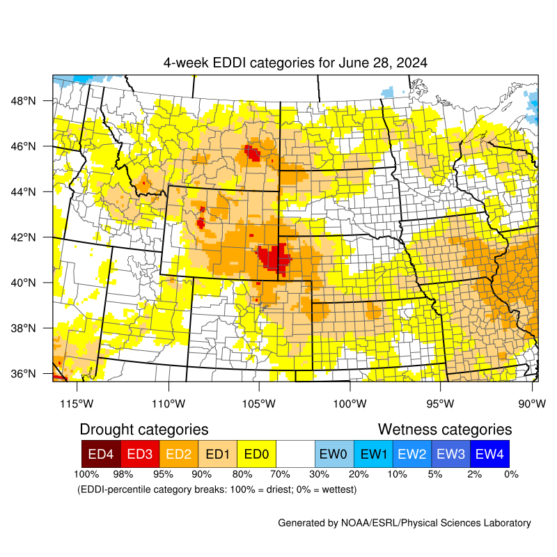
Open the mobile friendly version here: https://m.wfas.net SPC Fire Weather Outlooks Climate Prediction Center (CPC) 6-10 Day Temperature Outlook Click to Enlarge Climate Prediction Center (CPC) 6-10 Day Precipitation Outlook Click to Enlarge Climate Prediction Center (CPC) 8-14 Day Temperature Outlook Click to Enlarge Climate Prediction Center (CPC) 8-14 Day Precipitation Outlook Click to Enlarge Latest U.S. Drought Monitor for Montana Click to Enlarge Latest U.S. Drought Monitor 12 Week Loop Click to Enlarge Latest 4-week Evaporative Demand Drought Index (EDDI) Click to Enlarge Contact: For questions, comments, or additional information please contact us anytime at 1-406-952-3790 *. You can also find us on Facebook, Twitter, and YouTube. *Note: Phone number above is not for public dissemination. Please refer the public calls to 1-406-453-2081. Social Media
Hazards
Thunderstorms
Weather Forecast
Area Forecast Discussion
Outlooks
Contact Us
Day 1 Fire Weather Risk
Click to EnlargeDay 2 Fire Weather Risk
Click to EnlargeDay 3 Fire Weather Risk
Click to Enlarge


Day 4 Fire Weather Risk
Click to EnlargeDay 5 Fire Weather Risk
Click to EnlargeDay 6 Fire Weather Risk
Click to Enlarge

Day 7 Fire Weather Risk
Click to Enlarge


SPC Day 1 Convective Outlook
Click to EnlargeSPC Day 2 Convective Outlook
Click to EnlargeSPC Day 3 Convective Outlook
Click to Enlarge


Day 1 Forecast High Temperatures
Click to EnlargeDay 2 Forecast High Temperatures
Click to EnlargeDay 3 Forecast High Temperatures
Click to Enlarge


Day 1 Forecast Low Temperatures
Click to EnlargeDay 2 Forecast Low Temperatures
Click to EnlargeDay 3 Forecast Low Temperatures
Click to Enlarge


Day 1 Forecast Minimum Relative Humidity (RH)
Click to EnlargeDay 2 Forecast Minimum Relative Humidity (RH)
Click to EnlargeDay 3 Forecast Minimum Relative Humidity (RH)
Click to Enlarge


Day 1 Forecast Maximum Relative Humidity (RH)
Click to EnlargeDay 2 Forecast Maximum Relative Humidity (RH)
Click to EnlargeDay 3 Forecast Maximum Relative Humidity (RH)
Click to Enlarge


Wind forecast for the next 3 hours
Click to EnlargeWind forecast for the next 3-6 hours
Click to EnlargeWind forecast for the next 6-9 hours
Click to Enlarge


Wind forecast for the next 9-12 hours
Click to EnlargeWind forecast for the next 12-15 hours
Click to EnlargeWind forecast for the next 15-18 hours
Click to Enlarge


Wind forecast for the next 18-21 hours
Click to EnlargeWind forecast for the next 21-24 hours
Click to EnlargeWind forecast for the next 24-27 hours
Click to Enlarge

Peak Winds over the next 3 Days
Click to Enlarge


NWS 3 Day Precipitation Forecast
Click to EnlargeWPC 5 Day Precipitation Forecast
Click to EnlargeWPC 7 Day Precipitation Forecast
Click to Enlarge

NWS 3 Day Snow Forecast
Click to Enlarge
419
FXUS65 KTFX 010719
AFDTFX
Area Forecast Discussion
National Weather Service Great Falls MT
119 AM MDT Sat Aug 1 2026
.KEY MESSAGES...
- After a hot day today, temperatures trend cooler into Sunday
behind a cold front.
- Critical fire weather conditions develop this afternoon,
persisting into Sunday.
- After a briefly cooler stretch behind the cold front,
temperatures trend back warmer mid-week.
&&
.DISCUSSION...
- Meteorological Overview:
Strong upper level ridging in place across the region will quickly
be ushered eastward through the day today as an upper level trough
slides east near the International Border. Ahead of the approaching
trough temperatures rise well into the 90s across the region,
reaching as high as 110F or so in typically heat prone areas. The
ongoing Extreme Heat Warnings and Heat Advisories are unchanged
with this update. Those with plans outside today should plan for
numerous breaks and for plenty of hydration.
A dry cold front arrives as the upper level troughing moves eastward
this afternoon. Ahead of the front, breezy southwesterly winds
look to develop in many areas, transitioning to a more
northwesterly direction behind the front late afternoon and into
the evening. The strongest cross barrier flow aloft holds off til
this evening and tonight, peaking in excess of 60 kts along the
Northern Rocky Mountain Front. The combination of cooling
temperatures near the surface behind the front and still mild
temperatures aloft will result in some ridgetop stability tonight
along the Rocky Mountain Front. This will aid in translating the
aforementioned stronger winds aloft to the surface in these areas
via mountain wave activity. The strongest winds aloft fade quickly
after sunrise Sunday, though the continued brisk westerly flow
aloft will keep gusty winds around through the day Sunday.
A quick moving trough in wake of the initial troughing that will be
exiting eastward by Sunday afternoon moves across the area Sunday
night. This trough looks to have enough moisture associated with
it to result in a brief stretch of light precipitation along the
Northern Rocky Mountain Front Sunday evening and overnight.
Temperatures aloft look to be quite cool, which will yield the
risk for some light snow near mountain peaks in Glacier NP over
this timeframe.
A cooler northwesterly flow aloft persists into the early week across
the region, resulting in a below average temperatures across the
region for a couple days. This trend looks to be short-lived however,
as temperatures begin to trend warmer by mid-week. -AM
- Forecast Confidence & Scenarios:
Strong winds tonight:
Ridgetop stability will yield a good setup for translating stronger
winds to the surface tonight near the Rocky Mountain Front. Given
the strongest winds aloft continue to take aim at the Northern Rocky
Mountain Front, and largely only nick the Southern Rocky Mountain
Front, no changes are being made to the ongoing High Wind Warning.
Should the stronger winds aloft trend much further southward,
additional High Wind Warnings may become necessary near the Southern
Rocky Mountain Front. -AM
&&
.AVIATION...
01/06Z TAF Period
VFR conditions will prevail across all terminals during this TAF
Period. However, smoke from wildfires has been periodically reducing
visibility at the KCTB and KHVR terminals this evening and will
continue to do so through at least 01/10Z. Across all terminals
after 01/18Z winds will begin to increase with the strongest winds
being at the KCTB terminal. At the KCTB terminal by the end of this
TAF Period winds will gust in excess of 40 kt. Across most of the
TAF sites smoke from wildfires will reduce slantwise visibility
during this TAF Period. At the KCTB terminal there will be
isolated instances of low-level wind shear at the very end of
this TAF Period. -IG
For KGTF: Winds will be light through 18Z. Between 18Z and 23Z
winds will increase and shift from the southwest to the west.
Between 21Z and 00Z there is a 70% chance for a 15 kt crosswind.
-IG
&&
.FIRE WEATHER...
Critical fire weather conditions are forecast this weekend across
all fire weather districts.
Gusty winds developing this afternoon ahead of a dry cold front will
combine with relative humidities approaching single digits to result
in critical fire weather conditions in most areas. Winds shift to a
more northwesterly direction this afternoon and evening behind the
cold front. While gusty winds diminish somewhat out over the plains
tonight, strong winds will develop along the Rocky Mountain Front
this evening, slowly expanding over the plains through the night and
into the day Sunday. Overnight humidity recovery is forecast to be
nearly non-existent where these winds are persistent overnight near
the Rocky Mountain Front.
Although cooler temperatures will be moving in behind the cold front
for Sunday, very low relative humidity will persist (Approaching
single digits once again). Combine this with forecast breezy
winds, and critical fire weather conditions will be around once
again for Sunday. -AM
&&
.PRELIMINARY POINT TEMPS/POPS...
GTF 103 63 85 50 / 0 0 0 0
CTB 97 55 75 45 / 0 0 0 0
HLN 100 60 84 50 / 0 0 0 0
BZN 101 57 90 49 / 0 0 0 0
WYS 91 48 86 40 / 0 0 0 0
DLN 95 55 88 47 / 0 0 0 0
HVR 106 62 86 48 / 0 0 0 0
LWT 101 61 85 49 / 0 0 0 30
&&
.TFX WATCHES/WARNINGS/ADVISORIES...
Red Flag Warning from noon today to 9 PM MDT Sunday for Central
and Eastern Lewis and Clark National Forest Areas-Chouteau and
Fergus Counties-Eastern Glacier/Toole/Central/Eastern
Pondera/Liberty-Helena and Townsend Ranger Districts of the
Helena National Forest-Hill and Blaine Counties-Lewis and Clark
National Forest Rocky Mountain District-Rocky Mountain Front-
Lincoln Ranger District of the Helena National Forest.
Heat Advisory from noon today to 3 AM MDT Sunday for Beaverhead
and Western Madison below 6000ft-Canyon Ferry Area-Eastern
Glacier, Western Toole, and Central Pondera-Eastern Pondera and
Eastern Teton-Eastern Toole and Liberty-Elkhorn and Boulder
Mountains-Gates of the Mountains-Helena Valley-Hill County-
Meagher County Valleys-Missouri Headwaters-Northern Blaine
County-Snowy and Judith Mountains.
High Wind Warning from 6 PM this evening to noon MDT Sunday for
East Glacier Park Region-Eastern Glacier, Western Toole, and
Central Pondera-Northern High Plains.
Extreme Heat Warning from noon today to noon MDT Sunday for
Bears Paw Mountains and Southern Blaine-Fergus County below
4500ft-Western and Central Chouteau County.
Extreme Heat Warning from noon today to 3 AM MDT Sunday for
Cascade County below 5000ft-Gallatin Valley-Judith Basin County
and Judith Gap-Madison River Valley.
&&
$$
http://www.weather.gov/greatfalls
Day 1
Day 2


Northern Rockies Area Fire Weather Outlook - Day 1
Click to EnlargeNorthern Rockies Area Fire Weather Outlook - Day 2
Click to EnlargeNorthern Rockies Area Fire Weather Outlook - Day 3
Click to Enlarge


MT Percent of Average Precipitation (%) - 7 Day
Click to EnlargeMT Percent of Average Precipitation (%) - 14 Day
Click to EnlargeMT Percent of Average Precipitation (%) - 30 Day
Click to Enlarge


Tweets by @NWSGreatFalls
#mtwx Tweets
 |
 |
 |
 |
|
Missoula Radar Loop Click to Enlarge |
Great Falls Radar Loop Click to Enlarge |
Billings Radar Loop Click to Enlarge |
Glasgow Radar Loop Click to Enlarge |
 |
 |
 |
 |
|
Regional Radar Loop Click to Enlarge |
Visible Satellite |
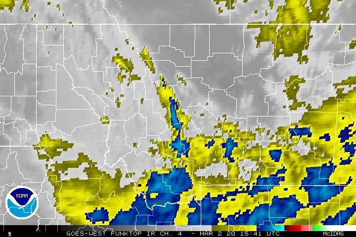
Infrared Satellite Click to Enlarge |
Water Vapor Satellite Click to Enlarge |


 Great Falls Radar
 Satellite
 Current Observations
 Forecast Discussion
 Montana Weather
 Fire Weather
 Winter Weather Forecasts
 Transportation Forecasts
 Weather Prediction Center
 Storm Prediction Center
 Aviation Weather
 Weather Stats