
Extremely critical fire weather conditions are expected to develop across the Great Basin and Southwest today, and exceptionally dry and windy conditions will promote rapid wildfire spread through the weekend. Scattered severe thunderstorms and heavy rain are possible across parts of the Ozark Plateau into lower Ohio Valley and parts of the northern Rockies into adjacent Great Plains. Read More >
New York CWSU
Center Weather Service Unit

 |
||
|
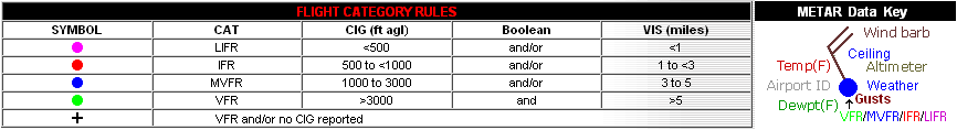
Click here for the latest regional surface plot.
|
 SIGMETS: ICE | TURB | IFR | CONV | ALL |
|
|---|


