National Weather Service United States Department of Commerce

Very Cold Temperatures from the Northern Plains to Ohio Valley; Swath of Snow from the Midwest to Central Appalachians

Arctic air will bring very cold temperatures and dangerous wind chills from the Northern Plains to the Ohio Valley today, expanding into the Mid-South and Mid-Atlantic on Sunday. A swath of accumulating snow is expected today from the Midwest to Central Appalachians, expanding into portions of the Mid-Atlantic tonight into Sunday. Read More >

 
Color code for Flight Category icons:  VFR   MVFR   IFR   LIFR
Click on airport or select "Hover" and mouse-over airport for TAFs (where available) and METARs.


Flight Category Rules
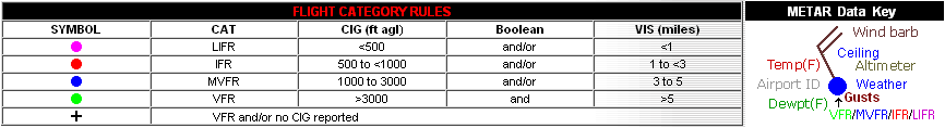
Click here for the latest regional surface plot.
  All Airmets/Sigmets
SIGMETS:  ICE | TURB | IFR | CONV | ALL
 

CCFP / Severe weather Outlooks
CONVECTION: | 4HR | 6HR | 8HR | Day1 | Day2


NE Radar Mosaic
RADAR:  Boston | New York | Philadelphia | Binghamton | State College | Northeast