Reporting Severe Weather
Reporting severe weather is essential! Regardless of the reporting method, each report must include the time & location of the event (and direction looking if applicable). Pictures tell a thousand words, but not when and where the weather occurred! If you do send photos, please let us know if you grant permission for us to use them in future spotter talks and outreach presentations.
How to Report:
Online: Use our online report form! For reporting tornadoes, please use our 1-800-667-1218 telephone line.
Email: fgf.reports@noaa.gov - A great way to include pictures & video.
Telephone: 1-800-667-1218 - Must have been through a spotter training course to use this line! Refer to info received during spotter training.
Facebook: Send a report to our Facebook page.
Twitter: Tweet us your reports by including the #ndwx, #mnwx or #nwsfgf hashtags or send them directly to @NWSGrandForks.
What to Report:
With any report, please include your location (city or distance from city, street intersection, lat./lon.), the time of the event, and who you are (public, spotter #, law enforcement, etc.)
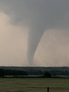
Tornadoes
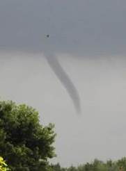
Wall Clouds & Funnel Clouds
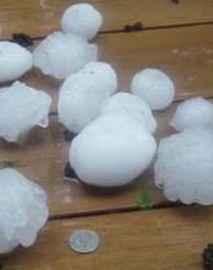
Hail
| Hail Size | Inches |
|---|---|
| Pea | 1/4 |
| Dime | 1/2 |
| Penny | 3/4 |
| Nickel | 7/8 |
| Quarter | 1 |
| Half Dollar | 1 1/4 |
| Ping Pong Ball | 1 1/2 |
| Golf Ball | 1 3/4 |
| Hen Egg | 2 |
| Tennis Ball | 2 1/2 |
| Baseball | 2 3/4 |
| Softball | 4 |
| Grapefruit | 4 1/2 |
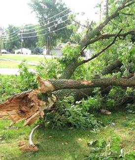
Damaging Winds
| Speed (mph) |
Designation | Description |
|---|---|---|
| <1 | Calm | Smoke rises vertically |
| 1-3 | Light air | Smoke drift indicates wind direction |
| 4-7 | Light breeze | Weather vane moves, leaves rustle |
| 8-12 | Light breeze | Leaves and twigs in constant motion |
| 13-18 | Mod breeze | Dust raised, small branches move |
| 19-24 | Fresh breeze | Small trees sway |
| 25-31 | Strong breeze | Large branches move |
| 32-38 | Moderate gale | Whole trees move, walking affected |
| 39-46 | Fresh gale | Twigs break off trees, walking difficult |
| 47-54 | Strong gale | Minor structural damage |
| 55-63 | Whole gale | Large tree branches break |
| 64-74 | Storm | Widespread damage |
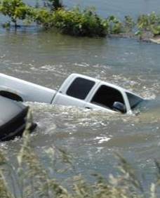
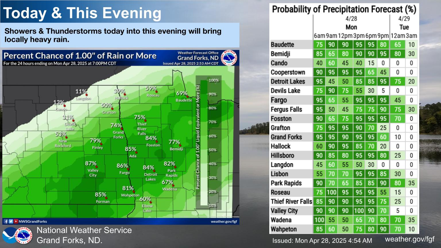
Flash Flooding & Heavy Rain
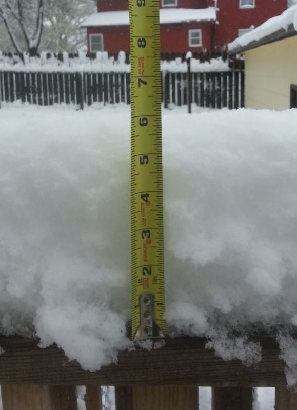
Snow & Ice
Outlooks, Watches & Warnings
Severe Weather Outlooks:
 |
 |
 |
 |
| Day 1 Outlook | Day 2 Outlook | Day 3 Outlook | Days 4-8 Outlooks |
Severe Weather Discussion, Watches, and Environmental Data:
 |
 |
 |
 |
| Mesoscale Discussions | Active Watches | Outlook, Watches & Radar | Mesoanalysis Data |
Eastern ND, Northwest MN, and West Central Minnesota Weather and Storm Reports:
 |
 |
 |
 |
| Current Radar & Warnings | Weather Story | Today's Storm Reports | Yesterday's Storm Reports |
 |
| Severe Weather Awareness Weeks in 2024 | |
|---|---|
| Minnesota: April 8-12, TOR Drill Apr 11th | North Dakota: Apr 22-26, TOR Drill Apr 25th |
Access Field Guide: Weather Spotter Field Guide
Take FREE Online Courses:
1. Role of the Skywarn Spotter
2. Skywarn Spotter Convective Basics
 |
For more information about our warning program us at the National Weather Service Grand Forks, please contact: NWS Grand Forks |
Frequently Asked Questions About SkywarnWhat is SKYWARN?
|
| Area Contacts for SkyWarn or Amateur Radio Information |
|
Contact your local County Emergency Manager in North Dakota or in Minnesota for location and time of the SKYWARN training in your county this spring. For additional information on the SKYWARN program, contact Jim Kaiser, FGF Warning Coordination Meteorologist at james.kaiser@noaa.gov. The National Weather Service will typically issue a warning for one or both of the following reasons; Doppler radar detects severe weather or SKYWARN spotters report severe weather. If a warning is issued for your location, you are in danger and need to seek shelter. The biggest supporters of the SKYWARN program are emergency response officials and amateur radio operators. One of the best ways to get involved is to talk with an amateur radio operator. If you have a scanner, tune in to a local amateur radio SKYWARN net (see list below) to get a feel for what is involved. |
| Amateur Radio SKYWARN Frequencies in: | |
|---|---|
Northwest Minnesota
|
|
Eastern North Dakota
|
|
|
Most of these sites can be linked together. In times of severe weather, this "link" allows amateur radio operators at the NWS in Grand Forks to communicate with those directly affected by the storm. The callsign for the NWS in Grand Forks is N0GF. Amateur radio operators are a vital part of the NWS severe weather warning program. Amateur Radio Clubs
Amateur Radio Links |
Spotter Training
The National Weather Service (NWS) and local county emergency managers host spotter training classes across eastern North Dakota and Northwest Minnesota every spring. These in-person spotter training classes are offered across many counties across the area. Every county in the NWS Grand Forks county warning area will have the option for an in-person spotter training class at least every other year. In addition to in-person sessions, three (3) virtual sessions will be offered in April and early May.
Both in-person and virtual training sessions are entirely free; and open to new & seasoned spotters alike.
Spotter talks are open to the public on a first come, first serve basis. No prior registration is required. The schedule at the bottom of the page includes all talks that have been scheduled to date. Scheduling usually takes place in February and March.
***If you have completed spotter training, and wish to become a registered storm spotter with the NWS Grand Forks office,
please fill out this linked form: Spotter Registration Form
Runs 60 to 90 minutes in length, is open to the public, and free of charge. No prior registration is required.
|
Virtual Classes Available - See Dates Below! Join the class at the scheduled time via the link below. |
|
|---|---|
|
Class Dates |
Virtual Spotter Training Joining Info |
|
Thursday, April 18th - 1pm to 3pm Thursday, April 25th - 10am to 12pm Thursday, May 2nd - 6pm to 8pm *No registration is needed, open to the public and groups. Google account not needed for participation. |
JOIN HERE: https://meet.google.com/xzc-egix-wur Or dial: (US) +1 629-888-0866 PIN: 564 335 537# |
.
2024 Spotter Training Schedule
Please click on calendar entry below to view more information about the training session.


 Follow us on YouTube