
A prolonged period of moderate to heavy snow affects the region tonight through early Sunday morning, resulting in hazardous road conditions. Portions of northeast Iowa into southwest Wisconsin could see snowfall amounts of 12+". Colder air arrives for Sunday through Tuesday with overnight wind chills in the single digits to teens below zero. Read More >
Overview
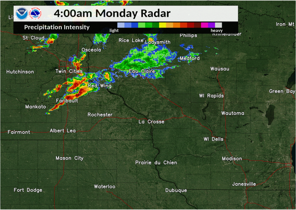
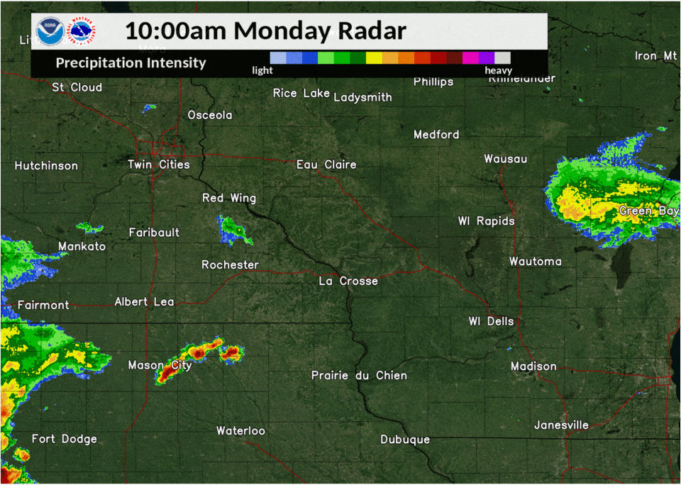
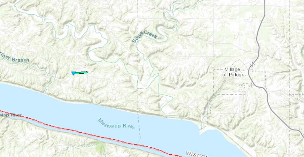
| Beginning during the pre-sunrise hours on August 10th, storms formed over southeast Minnesota and produced large hail. These moved east into western and central Wisconsin during the morning producing winds to 60 mph. Later in the morning, storms formed over northeast Iowa and produced large hail near Lourdes, Iowa. As the storms moved into southwest Wisconsin, they intensified and produced winds in the 60-70 mph range and a brief tornado. | 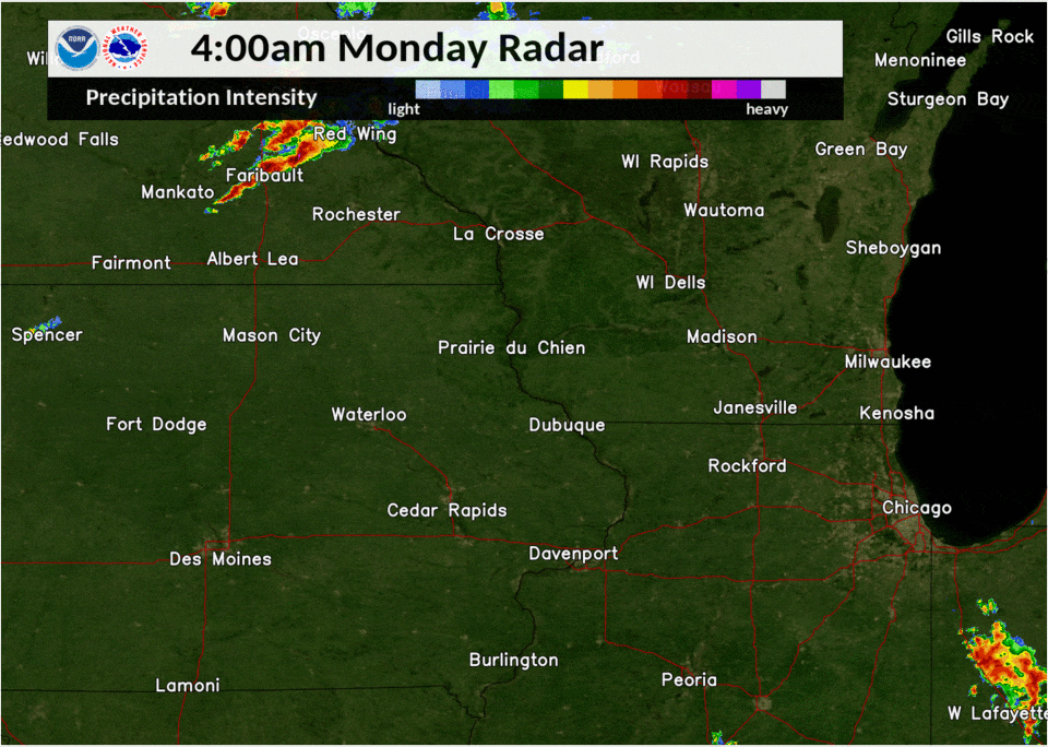 |
Tornadoes:
|
Tornado - Burton, Wisconsin
|
||||||||||||||||
The Enhanced Fujita (EF) Scale classifies tornadoes into the following categories:
| EF0 Weak 65-85 mph |
EF1 Moderate 86-110 mph |
EF2 Significant 111-135 mph |
EF3 Severe 136-165 mph |
EF4 Extreme 166-200 mph |
EF5 Catastrophic 200+ mph |
 |
|||||
Photos & Video:
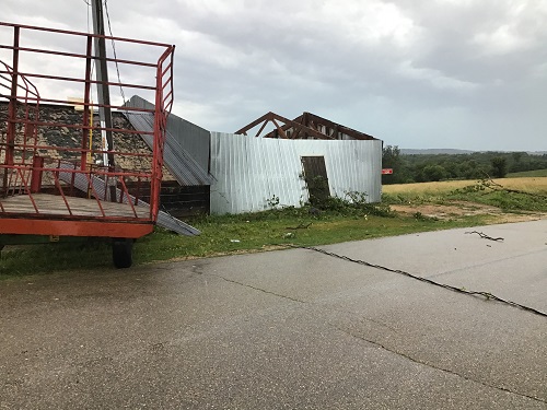 |
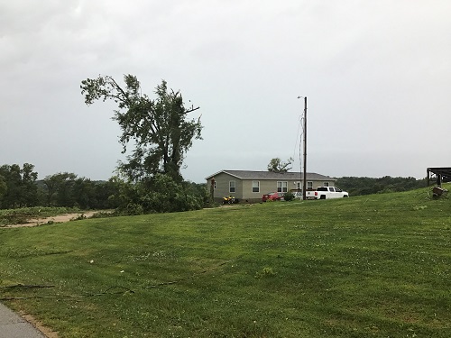 |
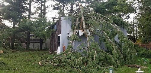 |
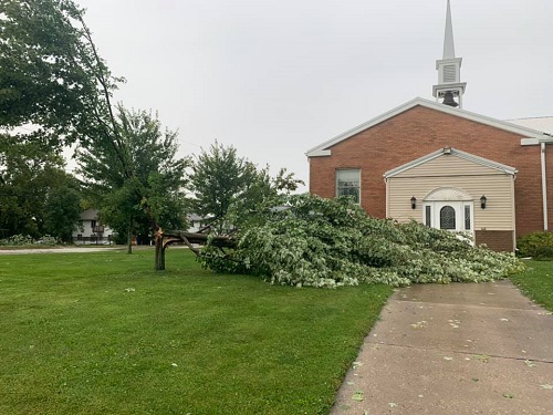 |
| Tornado Damage near Burton, WI (Photo courtesy of Grant Co. EM) |
Tornado Damage near Burton, WI (Photo courtesy of Grant Co. EM) |
Wind Damage in Platteville, WI (Photo Courtesy of Angela Dusseau Gillen) |
Wind Damage in Platteville, WI (Photo courtesy of Angela Denise Jones) |
Radar:
 |
 |
| Radar Loop: Sunrise Thunderstorms August 10, 2020 |
Radar Loop: Late Morning to Afternoon August 10, 2020 |
Storm Reports
PRELIMINARY LOCAL STORM REPORT...SUMMARY
NATIONAL WEATHER SERVICE LA CROSSE WI
235 PM CDT MON AUG 10 2020

..TIME...   ...EVENT...      ...CITY LOCATION...     ...LAT.LON...
..DATE...   ....MAG....      ..COUNTY LOCATION..ST.. ...SOURCE....
            ..REMARKS..

0527 AM     HAIL             1 WNW MANTORVILLE       44.07N 92.77W
08/10/2020  M1.00 INCH       DODGE              MN   PUBLIC


0609 AM     HAIL             1 W STOCKTON            44.03N 91.79W
08/10/2020  E0.25 INCH       WINONA             MN   PUBLIC


0622 AM     HAIL             1 W WILSON              43.95N 91.72W
08/10/2020  E0.75 INCH       WINONA             MN   TRAINED SPOTTER


0625 AM     HAIL             3 ESE STOCKTON          44.01N 91.71W
08/10/2020  E0.50 INCH       WINONA             MN   PUBLIC

            WIND GUSTS TO 30 MPH AS WELL.

0630 AM     HAIL             RIDGEWAY                43.92N 91.57W
08/10/2020  M2.00 INCH       WINONA             MN   PUBLIC

            RECEIVED VIA SOCIAL MEDIA WITH PICTURE. TIME
            ESTIMATED FROM RADAR.

0633 AM     TSTM WND GST     ETTRICK                 44.17N 91.27W
08/10/2020  E45 MPH          TREMPEALEAU        WI   TRAINED SPOTTER

            TRAINED SPOTTER REPORTED 45 MPH WIND GUST
            AND PEA SIZE HAIL.

0641 AM     HAIL             NODINE                  43.91N 91.44W
08/10/2020  E1.00 INCH       WINONA             MN   PUBLIC

            DIME TO QUARTER SIZED HAIL.

0646 AM     TSTM WND GST     2 NNE FRENCH ISLAND     43.88N 91.25W
08/10/2020  M30 MPH          LA CROSSE          WI   ASOS

            ASOS STATION KLSE LA CROSSE REGIONAL
            AIRPORT.

0650 AM     HAIL             2 NE MOUND PRAIRIE      43.80N 91.43W
08/10/2020  M0.25 INCH       HOUSTON            MN   CO-OP OBSERVER

            COOPERATIVE OBSERVER REPORTED 3/8 DIAMETER
            HAIL.

0653 AM     TSTM WND GST     3 ENE CATARACT          44.09N 90.79W
08/10/2020  M33 MPH          MONROE             WI   MESONET

            MESONET STATION AR731 2 E CATARACT.

0700 AM     HEAVY RAIN       1 W PLATTEVILLE         42.74N 90.49W
08/10/2020  E1.35 INCH       GRANT              WI   TRAINED SPOTTER


0700 AM     HAIL             TUNNEL CITY             44.00N 90.57W
08/10/2020  M0.50 INCH       MONROE             WI   TRAINED SPOTTER


0700 AM     TSTM WND GST     BLACK RIVER FALLS       44.30N 90.85W
08/10/2020  M58 MPH          JACKSON            WI   ASOS


0734 AM     TSTM WND GST     CAMP DOUGLAS            43.92N 90.27W
08/10/2020  M49 MPH          JUNEAU             WI   AWOS

            AWOS STATION KVOK VOLK FIELD.

0748 AM     TSTM WND DMG     5 SW NEW ROME           44.19N 89.96W
08/10/2020                   JUNEAU             WI   LAW ENFORCEMENT

            LAW ENFORCEMENT REPORTED A TREE DOWN IN
            ARMENIA TOWNSHIP.

0803 AM     TSTM WND DMG     2 N FRIENDSHIP          44.00N 89.83W
08/10/2020                   ADAMS              WI   LAW ENFORCEMENT

            LAW ENFORCEMENT REPORTED A TREE DOWN NEAR
            13TH DRIVE AND CYPRESS DRIVE.

1135 AM     HEAVY RAIN       1 WNW MANTORVILLE       44.07N 92.77W
08/10/2020  M0.14 INCH       DODGE              MN   PUBLIC


1221 PM     TSTM WND GST     2 SSE GLEN HAVEN        42.81N 91.06W
08/10/2020  E50 MPH          GRANT              WI   FIRE DEPT/RESCUE

            .

1224 PM     HAIL             2 SSE GLEN HAVEN        42.81N 91.06W
08/10/2020  E0.25 INCH       GRANT              WI   FIRE DEPT/RESCUE

            .

1228 PM     HAIL             PATCH GROVE             42.94N 90.97W
08/10/2020  E0.70 INCH       GRANT              WI   FIRE DEPT/RESCUE


1230 PM     TSTM WND GST     PATCH GROVE             42.94N 90.97W
08/10/2020  M63 MPH          GRANT              WI   FIRE DEPT/RESCUE

            .

1243 PM     HEAVY RAIN       PRAIRIE DU CHIEN        43.04N 91.14W
08/10/2020  E1.25 INCH       CRAWFORD           WI   PUBLIC


1249 PM     TSTM WND GST     BLOOMINGTON             42.88N 90.93W
08/10/2020  E60 MPH          GRANT              WI   FIRE DEPT/RESCUE

            .

1250 PM     TSTM WND GST     LANCASTER               42.85N 90.71W
08/10/2020  E60 MPH          GRANT              WI   FIRE DEPT/RESCUE

            .

0105 PM     TSTM WND DMG     2 S BURTON              42.69N 90.82W
08/10/2020                   GRANT              WI   PUBLIC

            STORM SPOTTER REPORTED A FUNNEL WITH CORN
            LEAVES/STOCKS AND STEEL SIDING DEBRIS.

0110 PM     TSTM WND DMG     5 NNW PLATTEVILLE       42.80N 90.51W
08/10/2020                   GRANT              WI   TRAINED SPOTTER

            TREE DAMAGE AND WIND GUSTS OF 62 MPH.

0111 PM     TSTM WND DMG     LANCASTER               42.85N 90.71W
08/10/2020                   GRANT              WI   EMERGENCY MNGR

            POWER OUTAGES IN LANCASTER/FENNIMORE AREAS.

0113 PM     TSTM WND DMG     POTOSI                  42.69N 90.71W
08/10/2020                   GRANT              WI   EMERGENCY MNGR

            POWER LINES AND TREES DOWN.

0114 PM     TSTM WND DMG     PLATTEVILLE             42.74N 90.48W
08/10/2020                   GRANT              WI   PUBLIC

            TREE FELL ON HOUSE.

0115 PM     TSTM WND DMG     PLATTEVILLE             42.73N 90.48W
08/10/2020                   GRANT              WI   PUBLIC

            4 ROADS BLOCKED OFF IN THE TOWN AND 8-10
            INCH TREES AND TREE LIMBS DOWN.

0120 PM     TSTM WND DMG     1 W PLATTEVILLE         42.74N 90.49W
08/10/2020                   GRANT              WI   TRAINED SPOTTER

            TREE DAMAGE AND POWER OUTAGES.

0147 PM     HEAVY RAIN       1 W PLATTEVILLE         42.74N 90.49W
08/10/2020  E2.50 INCH       GRANT              WI   TRAINED SPOTTER
Rain Reports
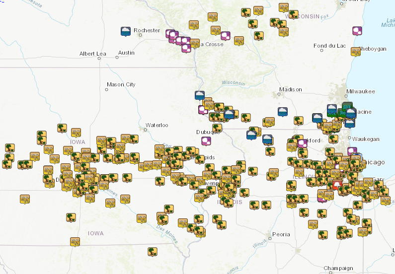
...24-hour Rainfall Reports...

Location                     Amount    Time/Date       Lat/Lon

...Iowa...

...Allamakee County...
Harpers Ferry 6.4 SSW        0.54 in   0700 AM 08/11   43.11N/91.20W
Postville 5.5 NE             0.30 in   0700 AM 08/11   43.14N/91.49W
5 SW Waukon Jct              0.06 in   0715 AM 08/11   43.11N/91.27W
Waukon 3N                    0.05 in   0600 AM 08/11   43.31N/91.46W
3 S Dorchester               0.04 in   0615 AM 08/11   43.42N/91.51W

...Chickasaw County...
Ionia 2W                     0.43 in   0700 AM 08/11   43.03N/92.50W
5 NE New Hampton             0.16 in   0830 AM 08/11   43.13N/92.26W
New Hampton                  0.15 in   0700 AM 08/11   43.06N/92.32W
New Hampton 0.4 SW           0.12 in   0700 AM 08/11   43.06N/92.32W

...Clayton County...
Mcgregor                     0.80 in   0839 AM 08/11   43.02N/91.19W
Guttenberg Dam 10            0.58 in   0600 AM 08/11   42.79N/91.10W
Garber                       0.54 in   0815 AM 08/11   42.74N/91.26W
Monona                       0.49 in   0839 AM 08/11   43.04N/91.39W
Littleport                   0.32 in   0700 AM 08/11   42.75N/91.37W
Elkader 6SSW                 0.19 in   0700 AM 08/11   42.78N/91.45W

...Fayette County...
Fayette                      0.40 in   0700 AM 08/11   42.88N/91.83W
Waucoma 1 WNW                0.20 in   0700 AM 08/11   43.06N/92.05W

...Floyd County...
2 NE Dougherty               0.58 in   0835 AM 08/11   42.95N/93.01W
Charles City                 0.25 in   0700 AM 08/11   43.06N/92.67W

...Howard County...
3 E Elma                     0.39 in   0835 AM 08/11   43.25N/92.38W
Saratoga                     0.03 in   0830 AM 08/11   43.35N/92.42W
Riceville                    0.01 in   0830 AM 08/11   43.36N/92.48W

...Mitchell County...
Osage 4.7 E                  0.08 in   0700 AM 08/11   43.28N/92.72W
St Ansgar                    0.06 in   0630 AM 08/11   43.38N/92.92W

...Winneshiek County...
Spillville                   0.40 in   0830 AM 08/11   43.21N/91.95W
Fort Atkinson 2.6 W          0.26 in   0700 AM 08/11   43.15N/91.98W
Decorah 4.9SE                0.21 in   0700 AM 08/11   43.26N/91.70W
7 ENE Decorah                0.10 in   0800 AM 08/11   43.34N/91.64W
1 ENE Jackson Junction       0.04 in   0840 AM 08/11   43.11N/92.04W

...Minnesota...

...Dodge County...
Claremont 2.5 ESE            0.09 in   0800 AM 08/11   44.04N/92.95W
2 WNW Byron                  0.02 in   0835 AM 08/11   44.05N/92.69W
Hayfield                     0.01 in   0837 AM 08/11   43.89N/92.85W
Hayfield 0.3 SSE             0.01 in   0800 AM 08/11   43.89N/92.85W
Hayfield 0.6 WNW             0.01 in   0700 AM 08/11   43.89N/92.86W

...Fillmore County...
Mabel                        0.02 in   0630 AM 08/11   43.52N/91.76W
Wykoff 3.1 NW                0.01 in   0700 AM 08/11   43.74N/92.31W

...Houston County...
1 NNE Houston                0.18 in   0645 AM 08/11   43.77N/91.57W
1 SSE Brownsville            0.01 in   0745 AM 08/11   43.69N/91.27W
La Crescent 1.0 WSW          0.01 in   0700 AM 08/11   43.83N/91.32W

...Mower County...
Austin 1.9 ENE               0.04 in   0800 AM 08/11   43.68N/92.94W
Austin 1.5 WSW               0.02 in   0700 AM 08/11   43.67N/93.00W

...Olmsted County...
Rochester                    0.11 in   0839 AM 08/11   44.04N/92.44W
Rochester                    0.03 in   0836 AM 08/11   44.08N/92.52W
2 NE Rochester               0.03 in   0600 AM 08/11   44.04N/92.44W
Rochester                    0.02 in   0835 AM 08/11   44.09N/92.51W
1 W Oronoco                  0.02 in   0745 AM 08/11   44.17N/92.55W
6 NNW Genoa                  0.01 in   0730 AM 08/11   44.19N/92.65W

...Wabasha County...
Lake City                    0.01 in   0839 AM 08/11   44.32N/92.44W

...Winona County...
Stockton 0.4 E               0.50 in   0600 AM 08/11   44.03N/91.76W
4.2 N Rollingstone           0.20 in   0600 AM 08/11   44.16N/91.81W
Whitewater State Park        0.01 in   0700 AM 08/11   44.05N/92.05W
Stockton 1.2 W               0.01 in   0700 AM 08/11   44.03N/91.79W
1 WSW Elba                   0.01 in   0615 AM 08/11   44.09N/92.03W

...Wisconsin...

...Adams County...
0.6 W Friendship             0.26 in   0700 AM 08/11   43.98N/89.83W
Friendship 6.4 NNE           0.20 in   0700 AM 08/11   44.06N/89.79W
Grand Marsh 1.0 W            0.06 in   0700 AM 08/11   43.89N/89.73W
Oxford 4.0 W                 0.03 in   0653 AM 08/11   43.79N/89.64W

...Buffalo County...
Mondovi 12.1 SSE             0.14 in   0700 AM 08/11   44.40N/91.60W
Alma Dam 4                   0.12 in   0600 AM 08/11   44.33N/91.92W

...Crawford County...
0.6 NE Prairie Du Chien      0.55 in   0700 AM 08/11   43.05N/91.13W
Prairie Du Chien  Airport    0.21 in   0835 AM 08/11   43.02N/91.12W
Steuben 4SE                  0.18 in   0630 AM 08/11   43.13N/90.84W
2.8 E Harpers Ferry          0.12 in   0745 AM 08/11   43.21N/91.10W
Gays Mills 6.1 SE            0.12 in   0700 AM 08/11   43.26N/90.76W
Gays Mills 1.0 NE            0.12 in   0700 AM 08/11   43.33N/90.84W
1 S De Soto                  0.11 in   0801 AM 08/11   43.41N/91.19W
De Soto                      0.07 in   0836 AM 08/11   43.42N/91.19W

...Grant County...
Cassville 7.8 ENE            1.49 in   0700 AM 08/11   42.75N/90.84W
Platteville                  1.34 in   0830 AM 08/11   42.74N/90.46W
Lancaster                    1.00 in   0741 AM 08/11   42.83N/90.69W
Muscoda                      0.20 in   0835 AM 08/11   43.19N/90.46W
Fennimore                    0.19 in   0839 AM 08/11   42.98N/90.66W
Muscoda 0.5 WSW              0.19 in   0815 AM 08/11   43.18N/90.44W
Boscobel                     0.16 in   0703 AM 08/11   43.15N/90.68W
Boscobel Airport             0.14 in   0824 AM 08/11   43.15N/90.68W

...Jackson County...
Black River Falls 1.7 NNE    0.55 in   0700 AM 08/11   44.32N/90.83W
Mather 3NW                   0.42 in   0700 AM 08/11   44.17N/90.35W

...Juneau County...
Necedah                      0.45 in   0648 AM 08/11   44.03N/90.08W
1.0 E Mauston                0.06 in   0800 AM 08/11   43.79N/90.06W
1 W Lyndon Station           0.05 in   0835 AM 08/11   43.71N/89.93W
3 SW Lemonweir               0.05 in   0835 AM 08/11   43.74N/90.05W
Mauston Airport              0.01 in   0835 AM 08/11   43.83N/90.13W
New Lisbon                   0.01 in   0816 AM 08/11   43.87N/90.17W

...La Crosse County...
Coon Valley 4.5 NNW          0.02 in   0700 AM 08/11   43.76N/91.06W

...Monroe County...
Warrens 4.7 WSW              0.25 in   0700 AM 08/11   44.10N/90.59W
Cashton 3 NNW                0.10 in   0734 AM 08/11   43.79N/90.80W
Wilton 4.2 E                 0.05 in   0700 AM 08/11   43.81N/90.44W

...Richland County...
1 SSE Richland Center        0.18 in   0839 AM 08/11   43.32N/90.38W

...Taylor County...
Medford                      0.01 in   0830 AM 08/11   45.30N/90.30W

...Trempealeau County...
Ettrick 3.2 NE               0.95 in   0730 AM 08/11   44.20N/91.23W
Galesville 4.7 E             0.04 in   0623 AM 08/11   44.08N/91.26W
Trempealeau Dam 6            0.02 in   0600 AM 08/11   44.00N/91.44W
1 NW Trempealeau             0.01 in   0630 AM 08/11   44.03N/91.46W

...Vernon County...
La Farge                     0.13 in   0831 AM 08/11   43.60N/90.63W
Hillsboro 2 SW               0.09 in   0700 AM 08/11   43.63N/90.38W
Hillsboro 0.5 WSW            0.08 in   0700 AM 08/11   43.65N/90.35W
0.5 E Viroqua                0.08 in   0700 AM 08/11   43.56N/90.88W
Genoa Dam 8                  0.06 in   0815 AM 08/11   43.57N/91.23W
Viroqua Municipal Airport    0.05 in   0835 AM 08/11   43.58N/90.90W
Stoddard 4.7 NNE             0.04 in   0700 AM 08/11   43.72N/91.17W
Viroqua 0.8 ESE              0.03 in   0700 AM 08/11   43.55N/90.87W

Observations are collected from a variety of sources with varying
equipment and exposures. We thank all volunteer weather observers
for their dedication. Not all data listed are considered official.
 |
Media use of NWS Web News Stories is encouraged! Please acknowledge the NWS as the source of any news information accessed from this site. |
|


 Weather Story
 Weather Map
 Local Radar