
A prolonged period of moderate snow affects the region from Friday night through early Sunday morning, potentially resulting in hazardous road conditions. Portions of northeast Iowa into southwest Wisconsin could see snowfall amounts of 9-12+". Colder air arrives for Sunday through Tuesday with overnight wind chills in the single digits to teens below zero. Read More >
Overview
|
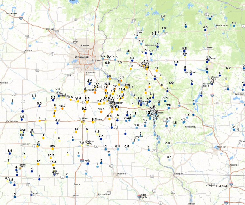
A storm system swept through the Midwest from Thursday, February 23rd, into early Saturday morning, February 25th, and produced a mix of heavy snow, thunderstorms, sleet, and freezing drizzle. The precipitation moved into the area during the evening hours of February 23rd with snow rates peaking at 1 to 3 inches per hour overnight. The heaviest snow fell across north central Iowa, into southeast Minnesota, and north-central Wisconsin with 6 to 13" common. There was some drifting as well as winds gusted in the 30 to 40 mph range. Elsewhere a mix of precipitation fell, which included thunderstorms with small hail. There was some icing from eastern Iowa into southern Wisconsin until the precipitation changed over to all snow by Friday evening, with an additional 1 to 3 inches falling in many areas. Where heavy snow fell roads were difficult to dangerous to travel on. This led to numerous accidents and school closings. |
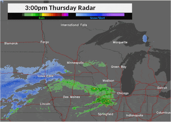 Radar loop from 3 pm Thursday (Feb.23) to 3 am Saturday (Feb.25) |
Peak Wind:
...Peak Wind Reports...

Location                     Speed     Time/Date

Charles City Airport         43 MPH    0155 AM 02/24
2 N Ionia                    42 MPH    0150 AM 02/24
Oelwein Municipal Airport    41 MPH    0155 AM 02/24
Rochester International Airp 39 MPH    0421 AM 02/24
1 ENE Dexter                 39 MPH    0116 AM 02/24
2 E Kasson                   37 MPH    0230 AM 02/24
Viroqua Municipal Airport    37 MPH    0255 AM 02/24
2 ESE Canton                 37 MPH    0245 AM 02/24
Decorah Municipal Airport    36 MPH    0635 AM 02/24
Boscobel Airport             35 MPH    1144 PM 02/23
2 SE Eyota                   35 MPH    0705 PM 02/24
1 E Ridgeway                 35 MPH    0300 AM 02/24
5 NW Frankville              34 MPH    0200 AM 02/24
3 W Saint Joseph             34 MPH    0255 AM 02/24
La Crosse Regional Airport   33 MPH    0550 AM 02/25
3 N Stewartville             33 MPH    0235 AM 02/24
3 NE Riceville               33 MPH    0206 AM 02/24
Platteville Municipal Airpor 33 MPH    1235 AM 02/24
Preston Airport              32 MPH    0213 AM 02/24
Mayo Helipad                 32 MPH    0313 AM 02/25
1 ENE Boscobel               31 MPH    0403 AM 02/24
2 SE Douglas                 31 MPH    0236 PM 02/24
Prairie Du Chien  Airport    31 MPH    0855 AM 02/25
Volk Field                   31 MPH    0743 AM 02/24
Austin Municipal Airport     30 MPH    0636 AM 02/24
Medford Airport              30 MPH    0555 AM 02/25
2 NNW Zumbro Falls           30 MPH    0307 AM 02/25
WFO La Crosse                30 MPH    0230 AM 02/24
Necedah                      30 MPH    0348 AM 02/24
Black River Falls Area Airpo 29 MPH    0835 PM 02/23
Sparta/Fort McCoy Airport    29 MPH    0435 AM 02/25
Byron                        28 MPH    1141 AM 02/24
Winona Municipal Airport     28 MPH    0553 AM 02/25
3 NE Lublin                  28 MPH    0714 AM 02/25
1 SSE Kellogg                27 MPH    0430 AM 02/25
3 SW Hammond                 26 MPH    1101 PM 02/23
2 N Tomah                    26 MPH    1202 AM 02/24

Observations are collected from a variety of sources with varying
equipment and exposures. Not all data listed are considered official.
Heavy Snow Thursday Night:
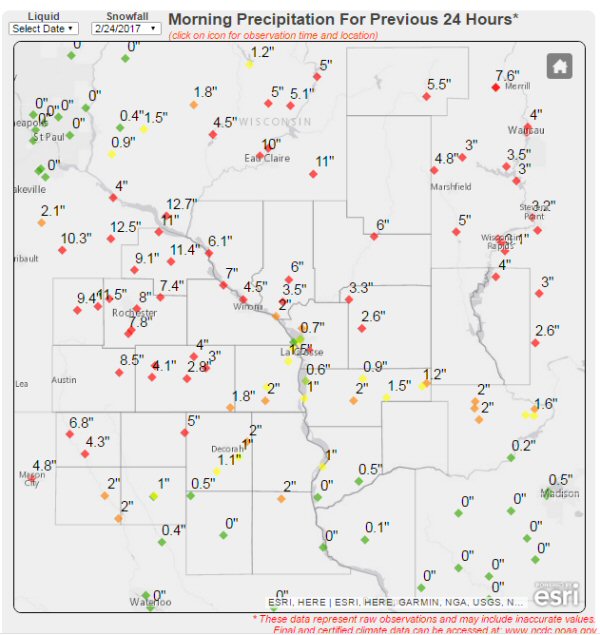
The heaviest snowfall of this storm occurred Thursday night, when snowfall rates of 1-3 inches per hour were noted at times, along with some lightning and thunder. Below is a look at snowfall totals ending Friday morning. For a rundown of storm total snowfall, please select the "Storm Total Snowfall" tab above.
Location                     Amount    Time/Date       Lat/Lon

...Iowa...

...Allamakee County...
Lansing                      1.0 in    0935 AM 02/24   43.37N/91.22W
6 SE Lansing                 1.0 in    0712 AM 02/24   43.29N/91.14W

...Chickasaw County...
Ionia 2W                     2.0 in    0700 AM 02/24   43.03N/92.50W
New Hampton                  1.0 in    0700 AM 02/24   43.06N/92.32W

...Clayton County...
Monona WWTP                  2.0 in    0700 AM 02/24   43.04N/91.40W

...Fayette County...
1 ENE Alpha                  1.0 in    0700 AM 02/24   43.01N/92.03W
Waucoma 1WNW                 0.5 in    0700 AM 02/24   43.06N/92.05W

...Floyd County...
Charles City                 2.0 in    0700 AM 02/24   43.06N/92.67W
Nashua 2sw                   2.0 in    0700 AM 02/24   42.94N/92.57W

...Howard County...
Cresco 1NE                   5.0 in    0800 AM 02/24   43.39N/92.09W

...Mitchell County...
St Ansgar                    6.8 in    0630 AM 02/24   43.38N/92.92W
Osage                        4.3 in    0700 AM 02/24   43.28N/92.81W

...Winneshiek County...
7 ENE Decorah                2.0 in    0700 AM 02/24   43.34N/91.64W
Calmar NE                    1.1 in    0700 AM 02/24   43.19N/91.86W
5 ESE Decorah                1.0 in    0700 AM 02/24   43.26N/91.70W

...Minnesota...

...Dodge County...
3 SE Hayfield               13.5 in    0857 AM 02/24   43.86N/92.80W
2 NE Kasson                 11.5 in    0530 AM 02/24   44.05N/92.72W
Mantorville                  9.5 in    1100 AM 02/24
Dodge Center                 9.4 in    0700 AM 02/24   44.03N/92.87W
Kasson                       7.5 in    0600 AM 02/24   44.03N/92.75W

...Fillmore County...
Spring Valley                6.0 in    0700 AM 02/24   43.69N/92.39W
1 W Fillmore                 6.0 in    0700 AM 02/24   43.74N/92.31W
Spring Valley 3E             4.1 in    0700 AM 02/24   43.68N/92.33W
1 SSE Pilot Mound            4.0 in    0700 AM 02/24   43.79N/92.03W
Lanesboro 2NE                3.0 in    0720 AM 02/24   43.73N/91.94W
Preston                      2.8 in    0810 AM 02/24   43.67N/92.07W
3 S Lanesboro                2.8 in    0931 AM 02/24   43.68N/91.97W
1 S Peterson                 1.8 in    0709 AM 02/24   43.77N/91.83W
Mabel                        1.8 in    0800 AM 02/24   43.52N/91.76W

...Houston County...
Hokah 2S                     2.0 in    0807 AM 02/24   43.72N/91.36W
4 NW Eitzen                  2.0 in    0800 AM 02/24   43.56N/91.51W
2 ENE Mound Prairie          2.0 in    1200 PM 02/24   43.79N/91.42W
Caledonia                    1.7 in    0700 AM 02/24   43.63N/91.50W
1 NNW La Crescent            1.5 in    0700 AM 02/24   43.83N/91.31W
Hokah WWTP                   1.5 in    0700 AM 02/24   43.76N/91.35W

...Mower County...
Austin 2SW                   9.0 in    0722 AM 02/24   43.64N/93.05W
Grand Meadow                 8.5 in    0500 AM 02/24   43.71N/92.56W
2 SW Austin                  7.9 in    0830 AM 02/24   43.65N/93.00W
1 NE Le Roy                  5.0 in    0708 AM 02/24   43.53N/92.49W

...Olmsted County...
2 S Rochester               12.5 in    0749 AM 02/24   43.99N/92.47W
3 SE Rochester              12.0 in    0600 AM 02/24   43.98N/92.43W
2 NNW Rochester             12.0 in    0700 AM 02/24   44.05N/92.49W
2 SSW Predmore              11.0 in    0645 AM 02/24   43.91N/92.34W
1 WNW Rochester             10.8 in    0748 AM 02/24   44.02N/92.50W
Byron 4 North               10.6 in    0700 AM 02/24   44.09N/92.64W
4 ESE Douglas               10.2 in    0700 AM 02/24   44.08N/92.48W
3 ESE Douglas               10.0 in    0700 AM 02/24   44.08N/92.52W
Stewartville                 9.5 in    0747 AM 02/24   43.86N/92.49W
Oronoco 1S                   9.0 in    0814 AM 02/24   44.15N/92.54W
Rochester 4NNW               8.5 in    0721 AM 02/24   44.09N/92.51W
Rochester International Airp 8.1 in    1200 PM 02/24   43.91N/92.50W
2 NE Rochester               8.0 in    0600 AM 02/24   44.04N/92.44W
Elgin 2ssw                   7.4 in    0700 AM 02/24   44.10N/92.27W

...Wabasha County...
Oak Center                  12.0 in    0851 AM 02/24   44.35N/92.40W
1 NE Wabasha                11.5 in    0600 AM 02/24   44.38N/92.03W
Elgin                       11.5 in    0713 AM 02/24   44.14N/92.25W
Theilman 1SSW               11.4 in    0815 AM 02/24   44.28N/92.19W
Plainview                   11.0 in    0701 AM 02/24   44.17N/92.17W
Lake City                   11.0 in    0700 AM 02/24   44.44N/92.28W
1 NW Plainview              11.0 in    0948 AM 02/24   44.17N/92.18W
Reads Landing               10.0 in    0858 AM 02/24   44.40N/92.08W
Wabasha                      9.6 in    0700 AM 02/24   44.38N/92.05W
3 SW Zumbro Falls            9.1 in    0740 AM 02/24   44.24N/92.46W
Zumbro Falls                 8.0 in    1020 AM 02/24   44.29N/92.42W

...Winona County...
Lewiston                     7.0 in    0825 AM 02/24   43.99N/91.87W
Minnesota City Dam 5         7.0 in    0700 AM 02/24   44.16N/91.81W
4SW Winona                   6.0 in    0813 AM 02/24   43.98N/91.71W
2 E Winona                   5.0 in    0714 AM 02/24   44.05N/91.62W
Winona Dam 5A                4.5 in    0600 AM 02/24   44.09N/91.67W
Pickwick 3NW                 4.0 in    1200 PM 02/24
La Crescent Dam 7            0.5 in    0600 AM 02/24   43.87N/91.31W

...Wisconsin...

...Adams County...
2 SE New Rome                4.0 in    0800 AM 02/24   44.21N/89.85W
Friendship                   3.7 in    0700 AM 02/24   43.98N/89.83W

...Buffalo County...
Alma Dam 4                   6.1 in    0600 AM 02/24   44.33N/91.92W

...Clark County...
1 N Dorchester               7.5 in    0949 AM 02/24   45.02N/90.33W
7 SSE Riplinger              5.0 in    0646 AM 02/24   44.74N/90.33W
Longwood                     4.5 in    1200 PM 02/24
2 N Dorchester               4.0 in    0500 AM 02/24   45.03N/90.33W

...Crawford County...
Eastman                      1.5 in    0700 AM 02/24
Lynxville Dam 9              1.0 in    0600 AM 02/24   43.21N/91.10W
Steuben 4SE                  0.5 in    0721 AM 02/24   43.13N/90.84W

...Grant County...
Lancaster 4wsw               0.1 in    0800 AM 02/24   42.83N/90.79W

...Jackson County...
8 E Osseo                    7.0 in    1031 AM 02/24   44.58N/91.05W
Hatfield                     6.2 in    1200 PM 02/24   44.42N/90.73W
Hixton                       6.0 in    0510 AM 02/24   44.38N/91.01W
Hatfield Dam                 6.0 in    0522 AM 02/24   44.41N/90.73W
Black River Falls Sewage     5.1 in    0830 AM 02/24   44.29N/90.85W
Black River Falls            4.0 in    0628 AM 02/24   44.30N/90.85W

...Juneau County...
Mauston                      3.0 in    0711 AM 02/24   43.80N/90.08W
Necedah                      2.0 in    0714 AM 02/24   44.03N/90.07W
Elroy                        1.5 in    0526 AM 02/24   43.74N/90.27W

...La Crosse County...
La Crosse Weather Office     3.1 in    1200 PM 02/24   43.82N/91.19W
West Salem                   2.5 in    0700 AM 02/24
Mindoro                      2.0 in    0713 AM 02/24   44.02N/91.10W
Holmen 2s                    2.0 in    0700 AM 02/24   43.93N/91.25W
La Crosse Regional Airport   1.7 in    1200 PM 02/24   43.88N/91.26W
3 SSE La Crosse              1.5 in    0719 AM 02/24   43.79N/91.20W
La Crosse 4NNW               1.1 in    0730 AM 02/24   43.87N/91.27W
Downtown La Crosse           0.5 in    0358 AM 02/24   43.81N/91.25W

...Monroe County...
Four Corners                 3.3 in    0700 AM 02/24   44.09N/90.91W
Sparta                       2.6 in    0800 AM 02/24   43.94N/90.82W
3 WNW Kendall                1.6 in    0700 AM 02/24   43.81N/90.44W
Tomah                        1.0 in    0548 AM 02/24   43.99N/90.50W

...Taylor County...
Medford                      5.8 in    0709 AM 02/24   45.14N/90.35W
2 SSW Stetsonville           4.0 in    0647 AM 02/24   45.05N/90.33W

...Trempealeau County...
Osseo                       10.0 in    0700 AM 02/24
3 SSE Elk Creek              8.0 in    0537 AM 02/24   44.39N/91.38W
Arcadia                      8.0 in    0702 AM 02/24   44.26N/91.49W
Eleva                        7.0 in    0934 AM 02/24   44.58N/91.47W
Ettrick 4WNW                 6.0 in    0744 AM 02/24   44.19N/91.34W
Galesville                   5.0 in    0628 AM 02/24   44.09N/91.36W
Ettrick                      4.0 in    0933 AM 02/24   44.17N/91.27W
1 S Osseo                    4.0 in    0139 AM 02/24   44.56N/91.22W
Galesville 2wsw              3.5 in    0600 AM 02/24   44.07N/91.39W
Trempealeau Dam 6            2.0 in    0600 AM 02/24   44.00N/91.44W

...Vernon County...
Hillsboro WSW                2.0 in    0700 AM 02/24   43.65N/90.35W
Viroqua                      2.0 in    0700 AM 02/24   43.56N/90.88W
La Farge                     1.5 in    0700 AM 02/24   43.57N/90.64W
5 NNE Stoddard               1.2 in    0758 AM 02/24   43.72N/91.17W
Hillsboro 2sw                1.2 in    0700 AM 02/24   43.63N/90.38W
Westby                       1.0 in    0602 AM 02/24   43.65N/90.86W
Genoa Dam 8                  1.0 in    0600 AM 02/24   43.57N/91.23W
Westby 3ENE                  0.9 in    0700 AM 02/24   43.67N/90.81W
Stoddard                     0.6 in    0700 AM 02/24   43.66N/91.22W

Observations are collected from a variety of sources with varying
equipment and exposures. Not all data listed are considered official.
Storm Total Snowfall:
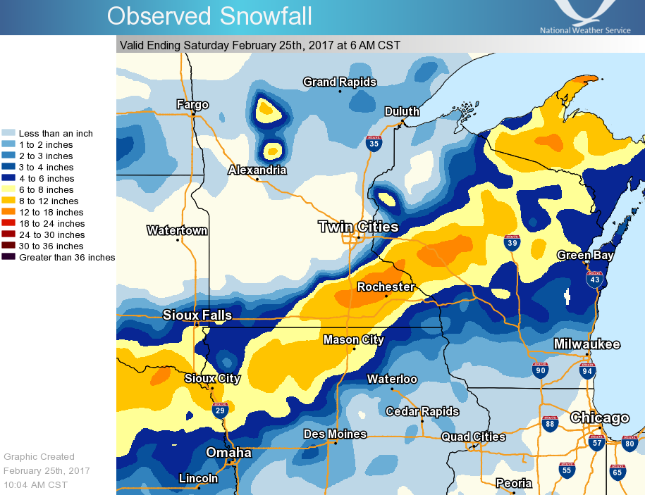 |
Below is a look at observed storm total snowfall ending Saturday morning. Please note that not as many observations were available for total snowfall as for 1-day snowfall ending Friday morning. Please select the "Heavy Snow Thursday Night" tab to see additional observations.
Location Amount Time/Date Lat/Lon
...Iowa...

...Chickasaw County...
Ionia 2W                     4.0 in    0700 AM 02/25   43.03N/92.50W
New Hampton                  2.0 in    0700 AM 02/25   43.06N/92.32W

...Clayton County...
Monona WWTP                  3.0 in    0700 AM 02/25   43.04N/91.40W
Volga 1NE                    1.5 in    0700 AM 02/25   43.81N/91.52W
Guttenberg Dam 10            1.0 in    0600 AM 02/25   42.78N/91.10W
Elkader 6SSW                 0.7 in    0700 AM 02/25   42.78N/91.45W

...Fayette County...
Waucoma 1WNW                 1.5 in    0700 AM 2/25    43.06N/92.05W
Fayette                      0.7 in    0700 AM 02/25   42.85N/91.82W

...Floyd County...
Cresco 1NE                   6.2 in     0700 AM 02/25   43.39N/92.09W
Charles City                 6.0 in    0700 AM 02/25   43.06N/92.67W
Nashua 2SW                   3.5 in    0700 AM 02/25   42.94N/92.57W

...Howard County...
Elma                         3.4 in    0700 AM 02/25   43.24N/92.44W

...Mitchell County...
St Ansgar                    8.4 in    0630 AM 02/25   43.38N/92.92W

...Winneshiek County...
5 ESE Decorah                2.1 in    0700 AM 02/25   43.26N/91.70W

...Minnesota...

...Fillmore County...
1 W Fillmore                 8.1 in    0700 AM 02/25   43.74N/92.31W
Spring Valley                7.9 in    0700 AM 02/25   43.69N/92.39W
1 SSE Pilot Mound            6.0 in    0700 AM 02/25   43.79N/92.03W
Spring Valley 3E             5.8 in    0700 AM 02/25   43.68N/92.33W
Lanesboro 2NE                4.8 in    0715 AM 02/25   43.73N/91.94W
Preston                      4.0 in    0700 AM 02/25   43.67N/92.07W
1 S Peterson                 3.1 in    0709 AM 02/25   43.77N/91.83W

...Houston County...
Hokah WWTP                   4.0 in    0700 AM 02/25   43.76N/91.35W
Caledonia                    2.6 in    0700 AM 02/25   43.63N/91.50W

...Mower County...
Grand Meadow                 9.5 in    0520 AM 02/25   43.71N/92.56W

...Olmsted County...
Byron 4 North                13.6 in   0700 AM 02/25   44.09N/92.64W
2 SSW Predmore               11.5 in   0645 AM 02/25   43.91N/92.34W
Elgin 2ssw                   11.4 in   0700 AM 02/25   44.10N/92.27W
2 NE Rochester               11.0 in   0600 AM 02/25   44.04N/92.44W
Rochester International Airp 10.2 in   0554 AM 02/25   43.91N/92.50W

...Wabasha County...
Zumbro Falls                 15.0 in   0900 AM 02/25    44.28N/92.42W
Theilman 1SSW                14.2 in   0745 AM 02/25   44.28N/92.19W
Lake City                    13.0 in   0700 AM 02/25   44.44N/92.28W
2 ESE Wabasha                12.0 in   0800 AM 02/25   44.36N/92.01W
Wabasha                      10.6 in   0700 AM 02/25   44.38N/92.05W

...Winona County...
Altura 5W (White Water SP)   11.0 in    0700 AM 02/25   44.06N/92.04W
Lewiston                     10.0 in   0800 AM 02/25   43.98N/91.87W
Minnesota City Dam 5         8.0 in    0700 AM 02/25   44.16N/91.81W
Winona Dam 5A                7.5 in    0600 AM 02/25   44.09N/91.67W

...Wisconsin...

...Adams County...
Friendship                   6.7 in    0700 AM 02/25   43.98N/89.83W

...Buffalo County...
Alma Dam 4                   7.1 in    0600 AM 02/25   44.33N/91.92W

...Crawford County...
Eastman                      2.5 in    0700 AM 02/25
Lynxville Dam 9              1.5 in    0600 AM 02/25   43.21N/91.10W
Steuben 4SE                  1.5 in    0700 AM 02/25   43.13N/90.84W

...Jackson County...
Hatfield Dam                 8.0 in    0700 AM 02/25   44.41N/90.73W
Black River Falls Sewage     7.6 in    0700 AM 02/25   44.29N/90.85W

...Juneau...
Union Center                 4.5 in    0700 AM 02/25   43.68N/90.26W

...La Crosse County...
La Crosse Weather Office     6.2 in    0600 AM 02/25   43.82N/91.19W
Holmen 2S                    5.2 in    0700 AM 02/25   43.93N/91.25W
West Salem                   5.0 in    0700 AM 02/25   43.90N/91.10W
La Crosse Airport            3.4 in    0600 AM 02/25   43.88N/91.26W

...Monroe County...
Four Corners                 5.1 in    0700 AM 02/25   44.09N/90.91W
3 WNW Kendall                3.8 in    0700 AM 02/25   43.81N/90.44W
Sparta                       3.3 in    0800 AM 02/25   43.94N/90.82W

..Richland County...
Ithaca 2S                    2.3 in    0546 AM 02/25   43.34N/90.28W
Richland Center 4N           2.0 in    0700 AM 02/25   43.40N/90.39W

...Taylor County...
Medford                      7.5 in    0800 AM 02/25   45.13N/90.34W
Westboro 4E                  7.5 in    0800 AM 02/25   45.35N/90.12W
2 N Gilman                   6.0 in    0800 AM 02/25   45.20N/90.81W

...Trempealeau County...
Osseo                       13.0 in    0700 AM 02/25   44.58N/91.22W
Ettrick 4WNW                 7.8 in    0710 AM 02/25   44.19N/91.34W
Trempealeau Dam 6            6.0 in    0600 AM 02/25   44.00N/91.44W

...Vernon County...
Viroqua                      4.0 in    0700 AM 02/25   43.56N/90.88W
Hillsboro WSW                3.5 in    0700 AM 02/25   43.65N/90.35W
Westby 3ENE                  2.8 in    0700 AM 02/25   43.67N/90.81W
La Farge                     2.7 in    0700 AM 02/25   43.57N/90.64W
Genoa Dam 8                  2.0 in    0600 AM 02/25   43.57N/91.23W
Hillsboro 2SW                1.9 in    0700 AM 02/25   43.63N/90.37W
Stoddard                     1.1 in    0700 AM 02/25   43.66N/91.22W

Observations are collected from a variety of sources with varying
equipment and exposures. Not all data listed are considered official.
NWS Services:
 |
 |
 |
 |
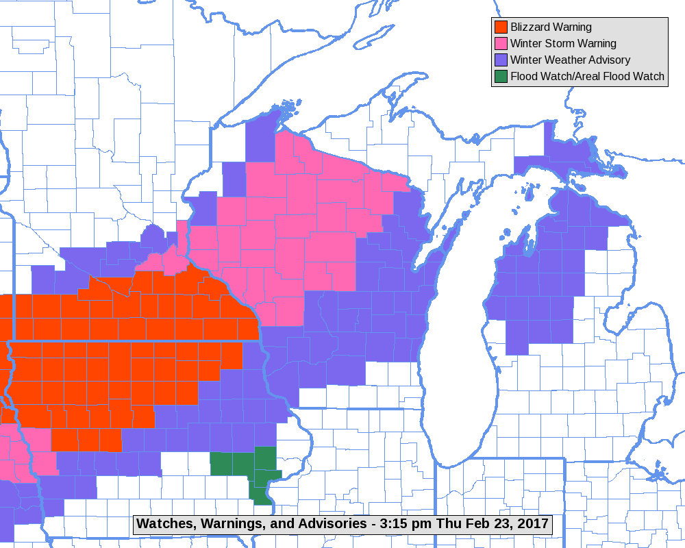
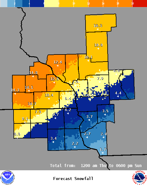
| Layout of Warnings and Advisories for Feb.23-24. | Snowfall forecast from NWS La Crosse. | Plot showing regional snow reports. | Plot showing local snow reports. |
Photos:
 |
 |
 |
 |
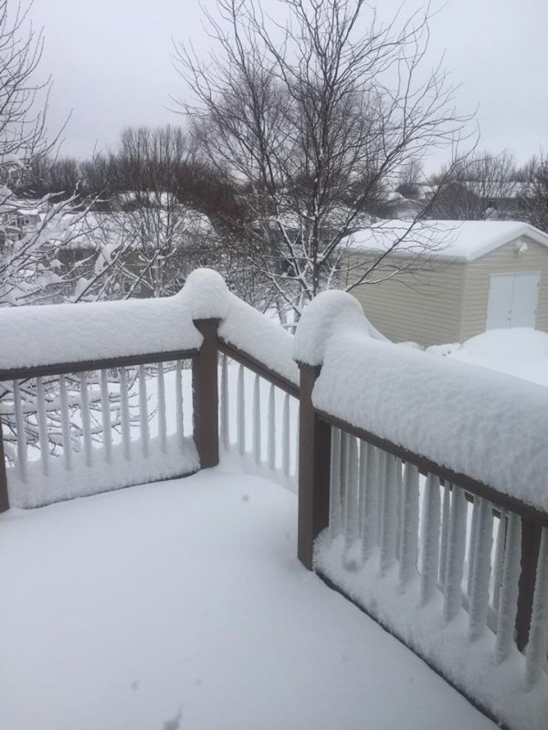
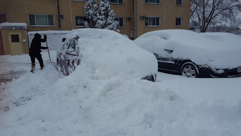
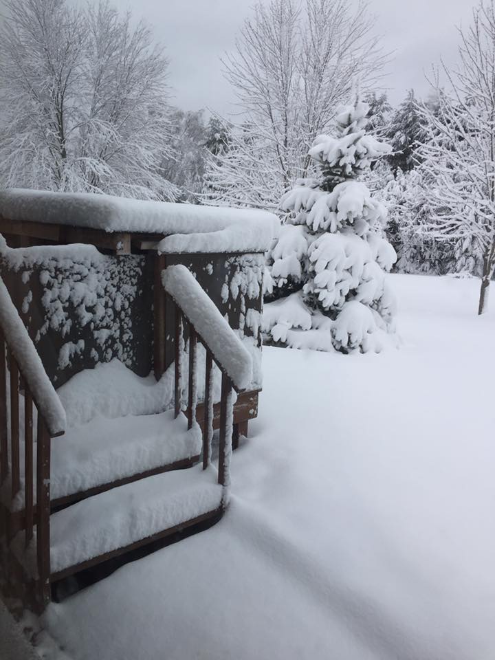
| Rochester, MN (Photo used with permission from William Mason) |
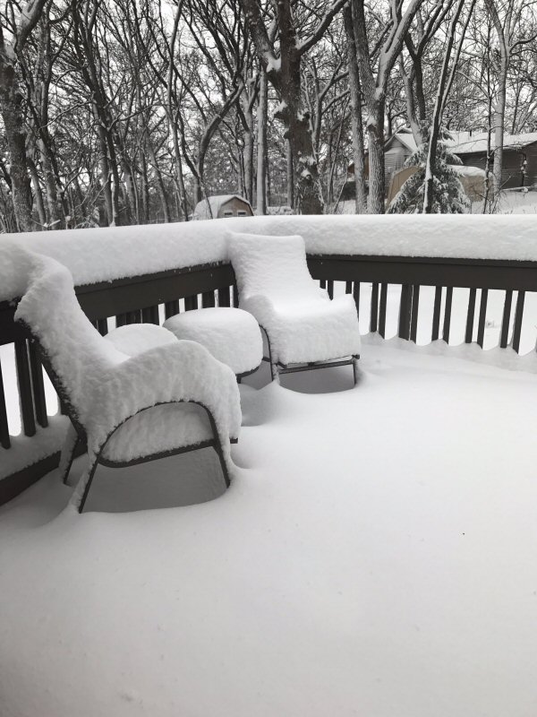
Rochester, MN (Photo used with permission from Alicia Zeone) |
Rochester, MN (Photo used with permission from Chad Corey) |
Rochester, MN (Photo used with permission from Patrick Hagge) |
 |
 |
 |
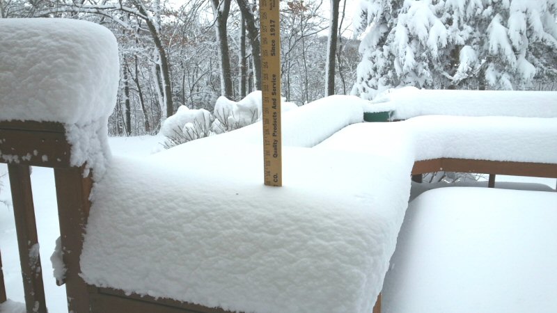 |
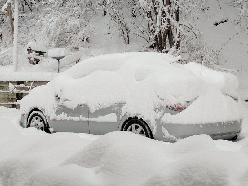
| Plainview, MN (Photo used with permission from Elizabeth Benoit) |
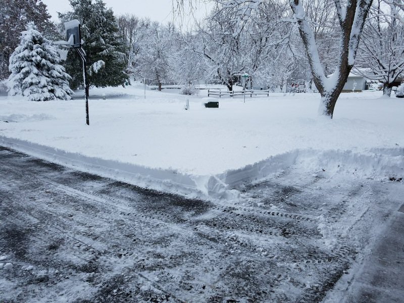
Fountain City, WI (Photo used with permission from Dana Hilton Jonsgaard) |
Fountain City, WI (Photo used with permission from Dana Hilton Jonsgaard) |
Mantorville, MN (Photo used with permission from Dan Kaufeld) |
 |
 |
||
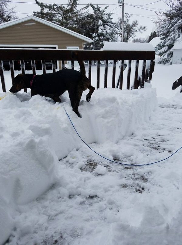
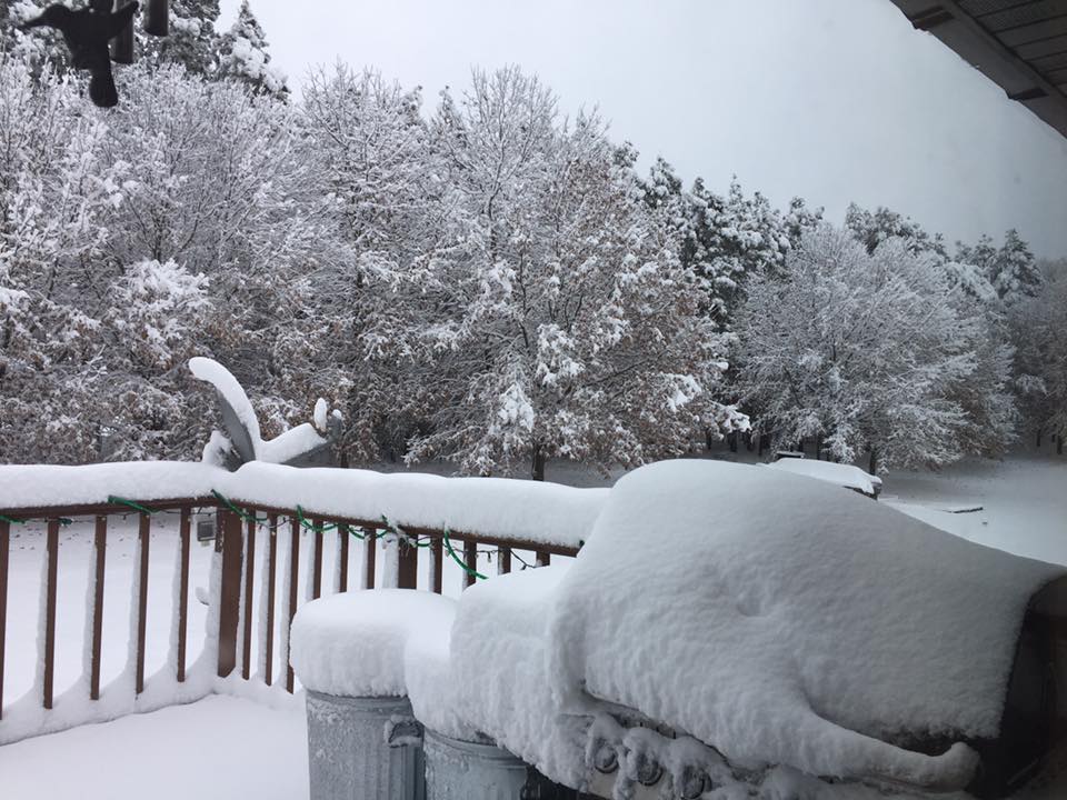
| Ice in Lancaster, WI (Photo by Grant County Emergency Management) |
Snow in Elgin, MN (Photo by @ThisisToots) |
Total Liquid Precipitation Reports
Location                     Amount    Time/Date

...Iowa...

...Allamakee County...
4 ENE Watson                 0.43 in   0245 AM 02/25
3 SE Waterville              0.41 in   1007 AM 02/25
3 S Dorchester               0.33 in   1000 AM 02/25

...Chickasaw County...
New Hampton                  0.90 in   0700 AM 02/25

...Clayton County...
Elkader 5NW                  0.99 in   1000 AM 02/25
Monona WWTP                  0.94 in   0700 AM 02/25
Guttenberg Dam 10            0.57 in   0600 AM 02/25
Littleport                   0.56 in   0945 AM 02/25
Garber                       0.53 in   1015 AM 02/25
Marquette-Bloody Run Creek   0.28 in   1000 AM 02/25
Elkader Turkey River         0.24 in   0345 AM 02/25

...Fayette County...
Oelwein                      0.65 in   0700 AM 02/25
Oelwein Municipal Airport    0.45 in   0555 AM 02/25
Eldorado                     0.34 in   0945 AM 02/25

...Floyd County...
Charles City                 0.79 in   0700 AM 02/25
Charles City Airport         0.43 in   0555 AM 02/25

...Mitchell County...
St Ansgar                    1.20 in   0630 AM 02/25

...Winneshiek County...
5 ESE Decorah                0.87 in   0700 AM 02/25
Decorah Municipal Airport    0.45 in   0555 AM 02/25

...Minnesota...

...Fillmore County...
1 W Fillmore                 0.92 in   0700 AM 02/25
Preston                      0.76 in   0800 AM 02/25
Lanesboro 2NE                0.66 in   0715 AM 02/25

...Houston County...
Caledonia                    0.65 in   0700 AM 02/25
Hokah WWTP                   0.62 in   0700 AM 02/25

...Mower County...
Grand Meadow                 0.88 in   0520 AM 02/25

...Olmsted County...
Byron 4 North                1.23 in   0700 AM 02/25
Rochester International Airp 0.80 in   0554 AM 02/25
Rochester Ap 2ne             0.80 in   0700 AM 02/25
2 NE Rochester               0.74 in   0600 AM 02/25
Mayo Helipad                 0.72 in   0553 AM 02/25

...Wabasha County...
Theilman 1SSW                1.06 in   0745 AM 02/25
Lake City                    0.96 in   0700 AM 02/25

...Winona County...
Minnesota City Dam 5         1.12 in   0700 AM 02/25
Winona Dam 5A                0.72 in   0600 AM 02/25
La Crescent Dam 7            0.38 in   0600 AM 02/25

...Wisconsin...

...Adams County...
Friendship                   0.62 in   0700 AM 02/25

...Buffalo County...
Alma Dam 4                   0.47 in   0600 AM 02/25

...Crawford County...
Lynxville Dam 9              0.79 in   0600 AM 02/25
De Soto                      0.69 in   1026 AM 02/25
Prairie Du Chien  Airport    0.59 in   0555 AM 02/25

...Grant County...
1 ENE Boscobel               0.66 in   0903 AM 02/25
Boscobel Airport             0.63 in   0553 AM 02/25

...Jackson County...
Black River Falls Sewage     0.71 in   0830 AM 02/25
1 E Black River Falls        0.51 in   1015 AM 02/25

...Juneau County...
2 N Cloverdale               0.57 in   1010 AM 02/25
Mauston                      0.41 in   1012 AM 02/25
Necedah                      0.40 in   0948 AM 02/25
Volk Field                   0.37 in   0558 AM 02/25
Mauston Airport              0.30 in   0555 AM 02/25

...La Crosse County...
Holmen 2s                    0.60 in   0700 AM 02/25
La Crosse Regional Airport   0.57 in   0553 AM 02/25
3 W Saint Joseph             0.56 in   1025 AM 02/25
La Crosse Weather Office     0.56 in   0600 AM 02/25

...Monroe County...
Four Corners                 0.87 in   0700 AM 02/25
Sparta                       0.48 in   0800 AM 02/25
3 WNW Kendall                0.39 in   0700 AM 02/25

...Richland County...
3 NW Avoca                   0.27 in   0408 AM 02/25

...Taylor County...
Medford                      0.56 in   0800 AM 02/25

...Trempealeau County...
Trempealeau Dam 6            0.59 in   0600 AM 02/25

...Vernon County...
Hillsboro WSW                1.00 in   0700 AM 02/25
Viroqua                      0.72 in   0700 AM 02/25
La Farge                     0.70 in   0700 AM 02/25
Genoa Dam 8                  0.53 in   0600 AM 02/25
Stoddard                     0.50 in   0700 AM 02/25
Westby 3ENE                  0.45 in   0700 AM 02/25


Observations are collected from a variety of sources with varying
equipment and exposures. Not all data listed are considered official.
 |
Media use of NWS Web News Stories is encouraged! Please acknowledge the NWS as the source of any news information accessed from this site. |
|


 Weather Story
 Weather Map
 Local Radar