NWS Birmingham, Alabama
Weather Forecast Office
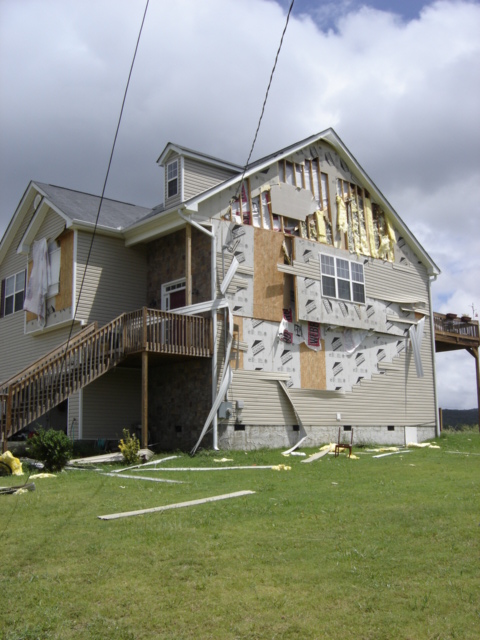
Sugar Valley Tornado - Calhoun County
|
Rating:
(Click for EF Scale) |
EF-1
|
|
Estimated Maximum Wind:
|
90 MPH
|
|
Injuries/Fatalities:
|
None
|
|
Damage Path Length:
|
0.1 of a Mile
|
|
Maximum Path Width:
|
50 Yards
|
|
Approximate Start Point:
|
33.64/-85.68 at 12:11 PM
|
A National Weather Service damage assessment team surveyed the storm damage in Calhoun County. It was determined that the damage was the result of a tornado. The tornado was rated an EF-1 on the Enhanced Fujita scale. Damage estimates were consistent with winds around 90 MPH. The total tornado damage path was less than 0.1 of a mile long and was 50 yards wide at its widest point.
A brief tornado damage path was found in the Sugar Valley Subdivision, just off State Highway 22 in the southeastern portion of Calhoun County. One house was badly damaged in the subdivision.
Damage Photos
|
||||||||||
Current Hazards
National Outlooks
Tropical
Local Storm Reports
Public Information Statement
Graphical Hazardous Weather Outlook
Current Conditions
Regional Weather Roundup
Rivers and Lakes
Drought Monitor
Forecasts
Fire Weather
Aviation Weather
Graphical Forecasts
Forecast Discussion
Air Quality
Climate and Past Weather
Past Events
Storm Data
Tornado Database
Daily Rainfall Plots
Tropical Cyclone Reports
Warnings and Other Products
Tornado Warnings
Severe Thunderstorm Warnings
Flash Flood Warnings
Winter Weather Warnings
Special Weather Statements
Non-Precipitation Warnings
Flood/River Flood Warnings
Productos en Español
Conciencia y Preparación
Previsión de 7 Días
Weather Safety
NOAA Weather Radio
Severe Weather Preparedness
Severe Safety Rules
Tornado Safety Rules
Severe Safety w/ ASL
Awareness Weeks
Severe Weather
Hurricane Preparedness
Summer Safety Campaign
Winter Weather
US Dept of Commerce
National Oceanic and Atmospheric Administration
National Weather Service
NWS Birmingham, Alabama
465 Weathervane Road
Calera, AL 35040
205-664-3010
Comments? Questions? Please Contact Us.