Overview
|
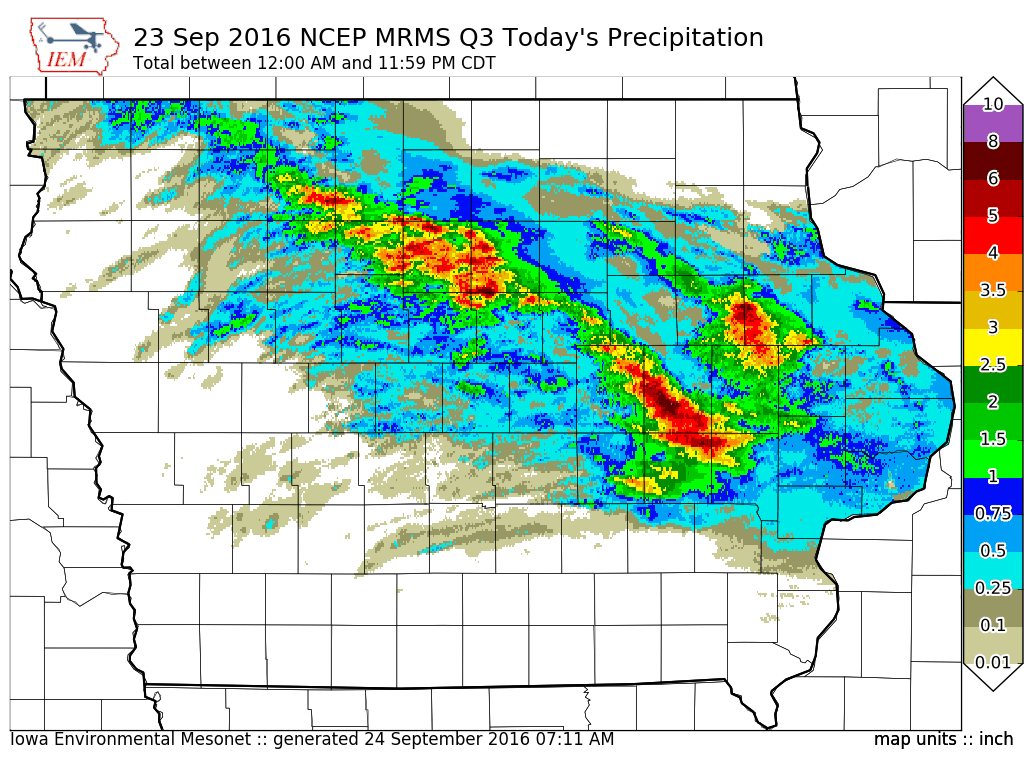
Extremely heavy rainfall, flash flooding, and major river flooding besieged northeastern and east central Iowa during the latter part of September of 2016. Many places saw rivers rise to levels not seen since the devastating floods of 2008. Numerous towns along the Shell Rock, Cedar, Wapsipinicon, and Winnebago rivers and their tributaries were inundated with flood waters. Flash flooding also befell areas under the heaviest rainfall as some places received over 5 to 10 inches in a few hours! Multiple storms tracked across the Ames area on the night of September 22 and led to flash flooding across the city. Finally, at least one tornado and areas of damaging winds and large hail battered northern Butler and southern Floyd counties on the evening of September 21. |
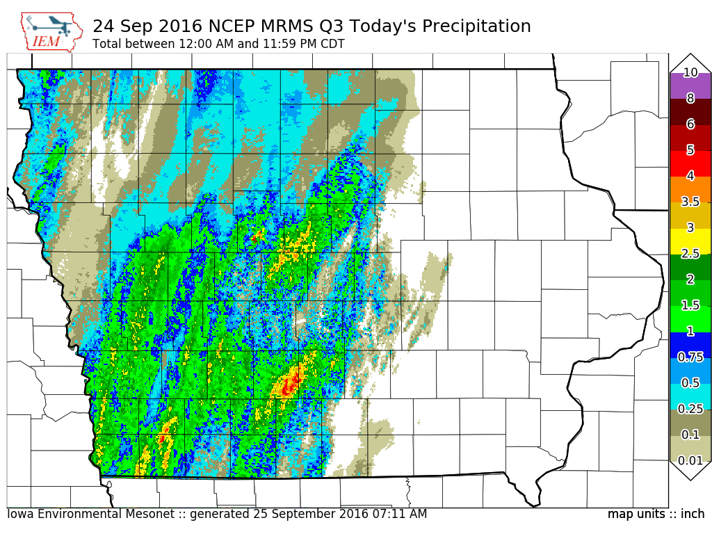
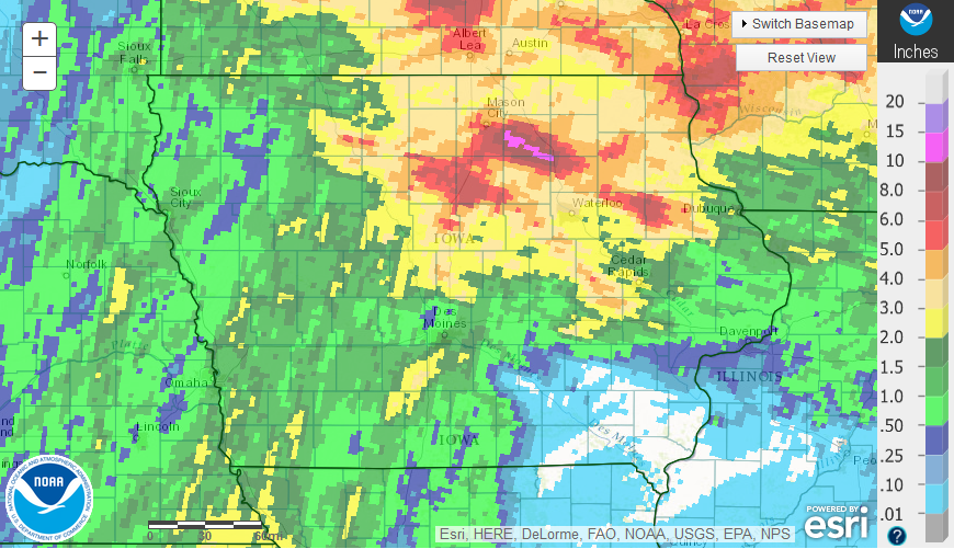 Total Rainfall Amounts across Iowa from September 21-25, 2016 |
Event Recap
It took a combination of several extraordinary events to bring about the floods of September 2016.
|
Antecedent Conditions The summer of 2016 had been marked by unseasonably wet conditions across parts of Minnesota, northern Iowa, and southern Wisconsin. Multiple rounds of major flooding took place across northeast Iowa and southeast Minnesota. This rainfall primed the antecedent environment by saturating the ground throughout the area. By the start of the month, soil moisture content was 2 to 3 inches above normal in many locations, pushing the 95th percentile in terms of climatological rarity. To make matters worse, the agricultural crops had reached maturity by the middle of September and were no longer able to absorb any additional moisture. Multiple heavy rain events on September 7, 9, and 15 each brought a widespread one to two inches of rain to much of northern Iowa and brought rivers to bankfull stage multiple times. Some rivers had yet to recover from the last rainfall before the deluge of September 21 kicked off the flooding. |
 |
|
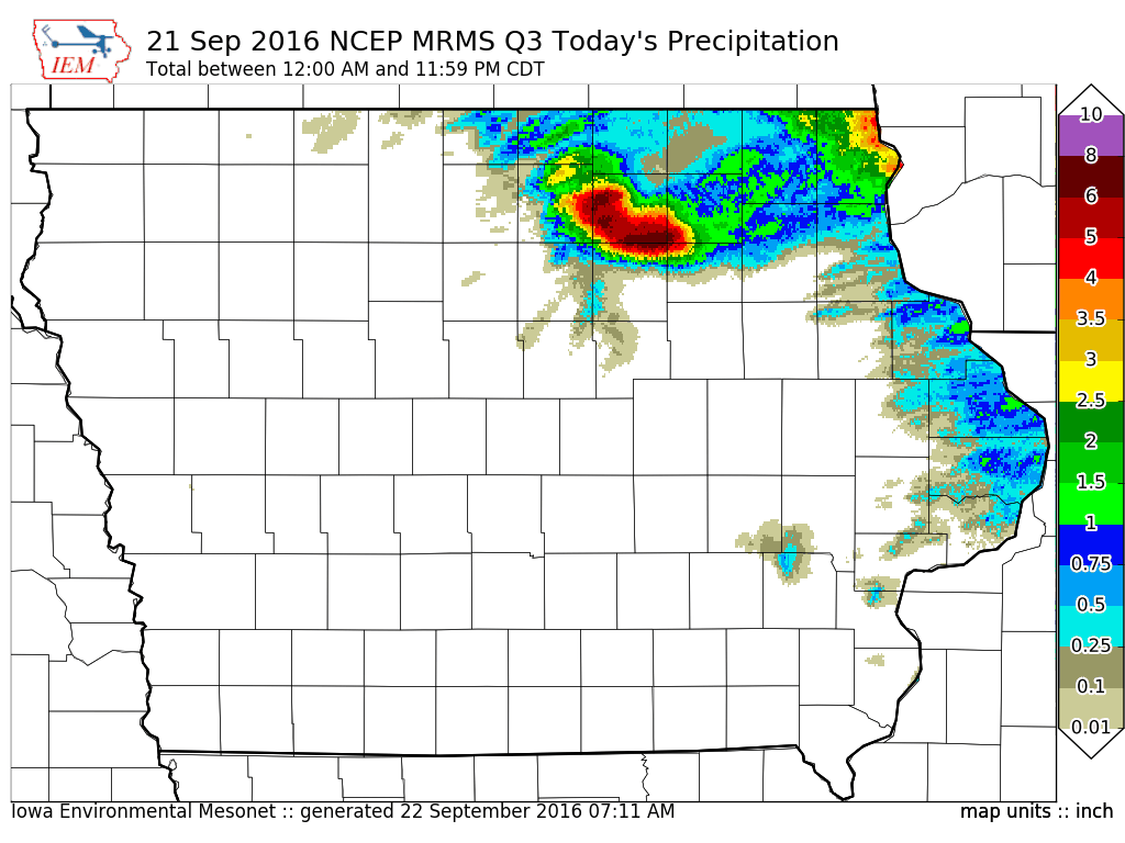
September 21 On the afternoon and evening of September 21, a stationary frontal boundary draped from the Mason City to Iowa Falls area served as the focus for multiple rounds of showers and thunderstorms. These thunderstorms trained repeatedly over eastern Cerro Gordo and western Floyd County before congealing into a massive high-precipitation supercell over southern Floyd and northern Butler County. This supercell brought at least one brief tornado, large hail and damaging winds to locations along its path. However, the biggest story was the rain. The supercell nearly stalled and at points retrograded across a small area of the Shell Rock River for over three hours! By the time it finally shifted east, a swath of 8 to 10 inches of rain with locally higher amounts of around a foot had fallen. Life-threatening flash flooding ensued over Floyd County that night and the Shell Rock River rose nine feet in 10 hours just upstream if the town of Greene in northern Floyd County. |
 |
|
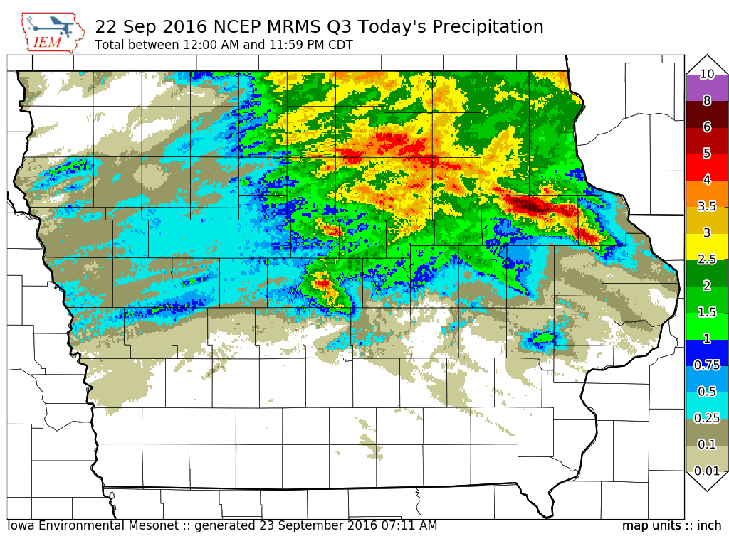
September 22 The front that spawned the heavy rainfall the previous night had shifted southwestward into central Iowa by the late afternoon of September 22. Multiple rounds of storms developed just west of Ames and tracked across the city, dumping 3 to 5 inches directly over the city. Multiple major city streets were flooded along with some buildings and homes. Small creeks and streams in the town rose rapidly out of their banks. The rain then spread north and east through the night and deluged northeast Iowa once again with 3 to 6 inches of rain, much of which fell over the areas hardest hit the night before. This brought renewed flash flooding and would push rivers to record heights along the Shell Rock River and near record heights along the Cedar River. |
 |
|
September 23-24 As the front lifted northward once again on the afternoon and evening of September 23, it once again ignited widespread showers and storms that brought heavy rain to the upper Des Moines, West Fork Cedar, and Iowa River valleys. Some of the heaviest rainfall amounts of over 5 inches were recorded from Pocahontas County southwestward to near Cedar Rapids. This heavy rain brought renewed rises to many rivers. One more round of heavy rain affected the southwest quarter of the state with flash flooding reported just southwest of Des Moines. Thankfully, this heavy rain all but missed northeast Iowa. |
 |
 |
Flooding
Record to near record flooding occurred on many major rivers across northeastern Iowa.
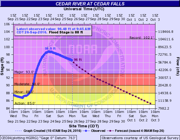
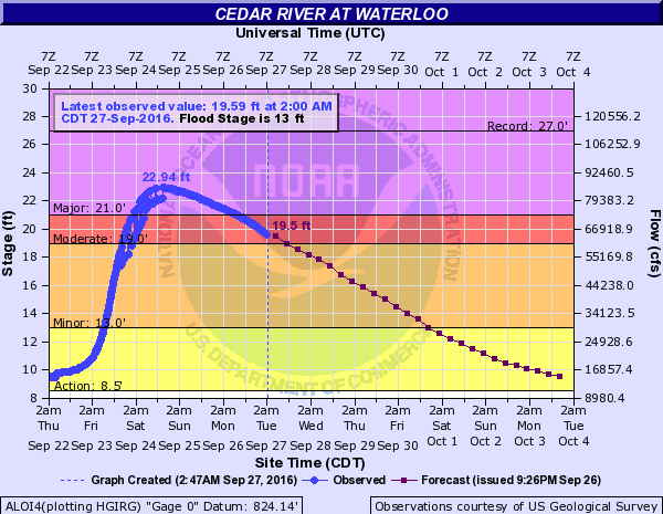
Hydrographs
 |
 |
 |
 |
| Cedar River at Cedar Falls: Crested at 98.90 feet @ 12:00pm on 9/24/16. (2nd Highest Crest on Record) |
Cedar River at Waterloo: Crested at 22.95 feet @ 4:45pm on 9/24/16. (2nd Highest Crest on Record) |
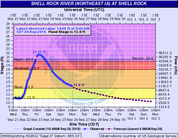
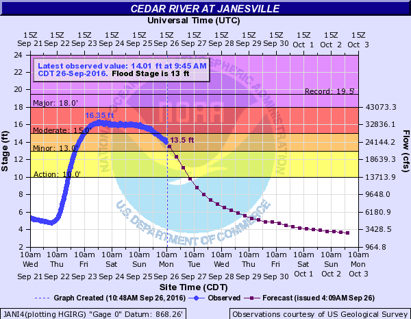
Shell Rock River at Shell Rock: Crested at 21/51 feet @ 4:14pm 9/23/16. (Highest on Record) | Cedar River at Janesville: Crested at 16.35 feet @ 10:30pm on 9/23/16. (3rd Highest Crest on Record) |
 |
 |
 |
 |
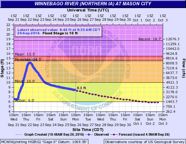
| Winnebago River at Mason City: Crested at 14.14 feet @ 6:15pm 9/22/16. (5th Highest Crest on Record) |
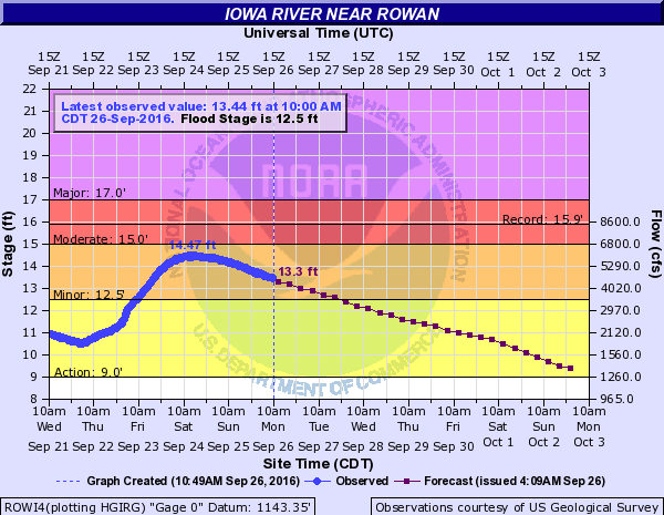
Iowa River at Rowan: Crested at 14.47 feet @ 4:30pm 9/24/16 (7th Highest Crest on Record) |
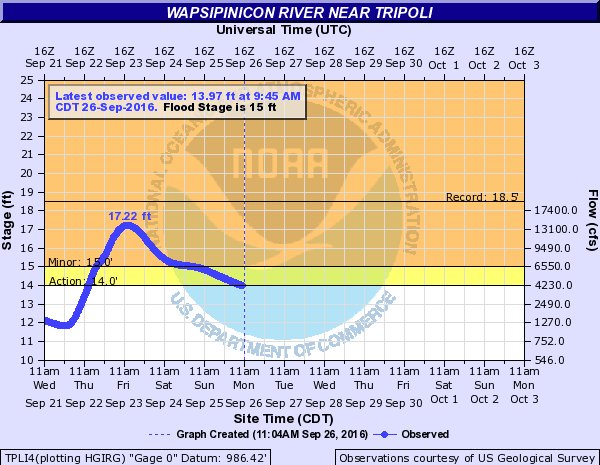
Wapsipinicon River at Tripoli: Crested at 17.22 feet @ 1:30pm 9/23/16 (4th Highest Crest on Record) |
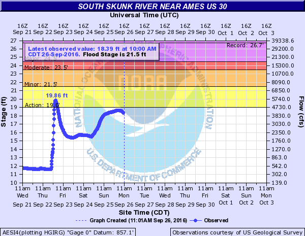
Skunk River at Ames hydrograph shows the rapid rise that took place following the heavy rain on 9/23. |
Photos & Video:
Coming Soon!Radar:
Coming Soon!Storm Reports
Below is a list of storm reports for the entire event, which include heavy rain reports. Click here to view a map of reports.
0355 PM     TSTM WND DMG     5 NNE ROCKWELL          43.05N 93.15W
09/21/2016                   CERRO GORDO        IA   TRAINED SPOTTER

            3 INCH TREE BRANCHES DOWN AND QUARTER SIZE
            HAIL.
0550 PM     TSTM WND DMG     1 SSW MASON CITY        43.13N 93.20W
09/21/2016                   CERRO GORDO        IA   AMATEUR RADIO

            TREE LIMBS DOWN APPROXIMATELY 3 INCHES IN
            DIAMETER.
0600 PM     HAIL             2 N ROCK FALLS          43.23N 93.08W
09/21/2016  E1.25 INCH       CERRO GORDO        IA   TRAINED SPOTTER

            HAIL LASTED FOR AROUND 10 MINUTES. STARTED
            OUT AS PEA SIZE AND GRADUALLY GOT BIGGER.
            WINDS ESTIMATED AROUND 20 MPH.
0624 PM     TORNADO          4 W GREENE              42.90N 92.88W
09/21/2016                   BUTLER             IA   EMERGENCY MNGR

            BRIEF ROPE TORNADO TOUCHDOWN 4 MILES WEST TO
            POSSIBLE WNW OF GREENE.

0630 PM     FLASH FLOOD      5 S MANLY               43.22N 93.21W
09/21/2016                   CERRO GORDO        IA   TRAINED SPOTTER

            TRAINED SPOTTER REPORTED CREEK IN PASTURE
            OUT OF BANKS AND RISING. LOCATION ESTIMATED.
0638 PM     TSTM WND DMG     2 ENE GREENE            42.90N 92.77W
09/21/2016                   BUTLER             IA   STORM CHASER

            OBSERVED TREE DAMAGE IN STORM CHASER LIVE
            VIDEO STREAM. MULTIPLE LARGE TREE LIMBS
            DOWN.

0645 PM     TSTM WND DMG     GREENE                  42.90N 92.80W
09/21/2016                   BUTLER             IA   EMERGENCY MNGR

            WIDESPREAD TREE DAMAGE THROUGHOUT TOWN.
            SEVERAL TREES ON HOUSES.
0650 PM     HAIL             1 NNW MASON CITY        43.17N 93.20W
09/21/2016  E0.75 INCH       CERRO GORDO        IA   TRAINED SPOTTER

0700 PM     FLASH FLOOD      ROCKWELL                42.98N 93.18W
09/21/2016                   CERRO GORDO        IA   DEPT OF HIGHWAYS

            DELAYED REPORT. COUNTY ROADS FLOODED NEAR
            ROCKWELL.
0711 PM     HAIL             GREENE                  42.90N 92.80W
09/21/2016  U1.00 INCH       BUTLER             IA   PUBLIC

            REPORT VIA SOCIAL MEDIA.
0749 PM     HAIL             GREENE                  42.90N 92.81W
09/21/2016  U1.00 INCH       BUTLER             IA   EMERGENCY MNGR
0815 PM     FLASH FLOOD      1 ENE MASON CITY        43.15N 93.18W
09/21/2016                   CERRO GORDO        IA   LAW ENFORCEMENT

            CERRO GORDO COUNTY DISPATCH NOTED THAT EAST
            PARK HAS BEEN FULLY CLOSED DUE TO FLOODING.
1040 PM     FLASH FLOOD      GREENE                  42.90N 92.80W
09/21/2016                   BUTLER             IA   EMERGENCY MNGR

            MANY ROADS CLOSED THROUGHOUT THE NORTHERN
            FOURTH OF BUTLER COUNTY. SHELL ROCK RIVER
            BEGINNING TO LEAVE ITS BANKS AND MOVING
            TOWARD BUSINESS IN DOWNTOWN GREENE.
            SANDBAGGING GOING ON IN GREENE AND
            CLARKSVILLE.
1047 PM     HEAVY RAIN       GREENE                  42.90N 92.80W
09/21/2016  M7.50 INCH       BUTLER             IA   FIRE DEPT/RESCUE

            STORM TOTAL.
0515 AM     TSTM WND DMG     4 N WELLSBURG           42.49N 92.93W
09/22/2016                   GRUNDY             IA   PUBLIC

            VIA SOCIAL MEDIA... DAMAGE TO SEVERAL LARGE
            TREES...TIME ESTIMATED.
1145 AM     HEAVY RAIN       5 E NORTHWOOD           43.45N 93.12W
09/22/2016  E6.25 INCH       WORTH              IA   PUBLIC

            VIA SOCIAL MEDIA.
1030 AM     HEAVY RAIN       1 NNE MASON CITY        43.17N 93.19W
09/22/2016  M4.21 INCH       CERRO GORDO        IA   MESONET

            MESONET STATION MASON CITY /MCWI4/.

1015 AM     HEAVY RAIN       1 N ALGONA              43.08N 94.23W
09/22/2016  M1.29 INCH       KOSSUTH            IA   MESONET

            MESONET STATION ALGONA /AGNI4/.

1000 AM     HEAVY RAIN       1 SW CLEAR LAKE         43.12N 93.38W
09/22/2016  M2.27 INCH       CERRO GORDO        IA   MESONET

            MESONET STATION CLEAR LAKE /CLKI4/.

1000 AM     HEAVY RAIN       4 S NEW HARTFORD        42.52N 92.63W
09/22/2016  M2.37 INCH       GRUNDY             IA   MESONET

            MESONET STATION BEAVER CK /NHRI4/.

1000 AM     HEAVY RAIN       STEAMBOAT ROCK          42.41N 93.06W
09/22/2016  M1.51 INCH       HARDIN             IA   MESONET

            MESONET STATION STEAMBOAT ROCK /STBI4/.

1000 AM     HEAVY RAIN       4 ESE LAKE CORNELIA     42.76N 93.62W
09/22/2016  M2.15 INCH       WRIGHT             IA   MESONET

            MESONET STATION 3 ESE LAKE CORNELIA /ROWI4/.

0945 AM     HEAVY RAIN       2 N TRIPOLI             42.84N 92.26W
09/22/2016  M2.10 INCH       BREMER             IA   MESONET

            MESONET STATION 1 N TRIPOLI /TPLI4/.

0820 AM     HEAVY RAIN       1 SW WATERLOO           42.48N 92.36W
09/22/2016  M1.56 INCH       BLACK HAWK         IA   COCORAHS

            COCORAHS STATION WATERLOO /IA-BH-18/.

0800 AM     HEAVY RAIN       CLARKSVILLE             42.78N 92.67W
09/22/2016  M2.30 INCH       BUTLER             IA   COCORAHS

            COCORAHS STATION CLARKSVILLE /IA-BU-3/.

0730 AM     HEAVY RAIN       1 S GRUNDY CENTER       42.36N 92.77W
09/22/2016  M1.56 INCH       GRUNDY             IA   CO-OP OBSERVER

            CO-OP OBSERVER STATION GRUNDY CENTER
            /GNDI4/.

0730 AM     HEAVY RAIN       2 NE LATIMER            42.78N 93.34W
09/22/2016  M1.05 INCH       FRANKLIN           IA   COCORAHS

            COCORAHS STATION 1 NE LATIMER /IA-FR-1/.

0717 AM     HEAVY RAIN       1 NNW WAVERLY           42.74N 92.48W
09/22/2016  M1.26 INCH       BREMER             IA   COCORAHS

            COCORAHS STATION WAVERLY /IA-BM-2/.

0700 AM     HEAVY RAIN       NORTHWOOD               43.45N 93.22W
09/22/2016  M4.13 INCH       WORTH              IA   CO-OP OBSERVER

            CO-OP OBSERVER STATION NORTHWOOD /NWDI4/.

0700 AM     HEAVY RAIN       SWALEDALE               42.98N 93.32W
09/22/2016  M2.40 INCH       CERRO GORDO        IA   COCORAHS

            COCORAHS STATION SWALEDALE /IA-CG-7/.

0700 AM     HEAVY RAIN       3 NW BADGER             42.64N 94.19W
09/22/2016  M1.18 INCH       WEBSTER            IA   COCORAHS

            COCORAHS STATION 3 WNW BADGER /IA-WB-5/.

0700 AM     HEAVY RAIN       HAMPTON                 42.75N 93.20W
09/22/2016  M1.36 INCH       FRANKLIN           IA   CO-OP OBSERVER

            CO-OP OBSERVER STATION HAMPTON /HPTI4/.

0700 AM     HEAVY RAIN       1 S LAKE MILLS          43.40N 93.53W
09/22/2016  M2.10 INCH       WINNEBAGO          IA   CO-OP OBSERVER

            CO-OP OBSERVER STATION LAKE MILLS /LMLI4/.

0700 AM     HEAVY RAIN       1 NNE CONRAD            42.23N 92.87W
09/22/2016  M1.30 INCH       GRUNDY             IA   CO-OP OBSERVER

            CO-OP OBSERVER STATION CONRAD /CRDI4/.

0700 AM     HEAVY RAIN       3 ENE MASON CITY        43.16N 93.14W
09/22/2016  M2.61 INCH       CERRO GORDO        IA   COCORAHS

            COCORAHS STATION 3 E MASON CITY /IA-CG-5/.

0700 AM     HEAVY RAIN       4 SSE BRISTOW           42.72N 92.89W
09/22/2016  M1.94 INCH       BUTLER             IA   CO-OP OBSERVER

            CO-OP OBSERVER STATION WEST FORK CEDAR RIVER
            /KSYI4/.

0700 AM     HEAVY RAIN       1 SE ALGONA             43.07N 94.22W
09/22/2016  M1.17 INCH       KOSSUTH            IA   COCORAHS

            COCORAHS STATION ALGONA /IA-KS-4/.

0700 AM     HEAVY RAIN       2 SSE WATERLOO          42.47N 92.34W
09/22/2016  M1.23 INCH       BLACK HAWK         IA   COCORAHS

            COCORAHS STATION 1 SSE WATERLOO /IA-BH-6/.

0700 AM     HEAVY RAIN       KANAWHA                 42.93N 93.80W
09/22/2016  M2.26 INCH       HANCOCK            IA   CO-OP OBSERVER

            CO-OP OBSERVER STATION KANAWHA /KANI4/.

0700 AM     HEAVY RAIN       1 ENE WEBSTER CITY      42.47N 93.80W
09/22/2016  M1.10 INCH       HAMILTON           IA   CO-OP OBSERVER

            CO-OP OBSERVER STATION WEBSTER CITY /WEBI4/.

0700 AM     HEAVY RAIN       SHELL ROCK              42.71N 92.58W
09/22/2016  M2.35 INCH       BUTLER             IA   CO-OP OBSERVER

            CO-OP OBSERVER STATION 2 W SHELL ROCK
            /SHRI4/.

0700 AM     HEAVY RAIN       2 N FOREST CITY         43.28N 93.63W
09/22/2016  M3.05 INCH       WINNEBAGO          IA   CO-OP OBSERVER

            CO-OP OBSERVER STATION 2 NNE FOREST CITY
            /FSCI4/.

0700 AM     HEAVY RAIN       1 ESE ALLISON           42.75N 92.78W
09/22/2016  M1.45 INCH       BUTLER             IA   CO-OP OBSERVER

            CO-OP OBSERVER STATION ALLISON /ASNI4/.

0700 AM     HEAVY RAIN       TRIPOLI                 42.81N 92.26W
09/22/2016  M2.30 INCH       BREMER             IA   CO-OP OBSERVER

            CO-OP OBSERVER STATION TRIPOLI /TRPI4/.

0655 AM     HEAVY RAIN       2 SSE FOREST CITY       43.23N 93.62W
09/22/2016  M2.19 INCH       HANCOCK            IA   AWOS

            AWOS STATION 2 SSE FOREST CITY /FXY/.

0655 AM     HEAVY RAIN       1 WNW CLARION           42.74N 93.76W
09/22/2016  M1.38 INCH       WRIGHT             IA   AWOS

            AWOS STATION CLARION /CAV/.

0654 AM     HEAVY RAIN       WATERLOO REGIONAL AIRPO 42.56N 92.40W
09/22/2016  M1.44 INCH       BLACK HAWK         IA   ASOS

            ASOS STATION WATERLOO MUNICIPAL AIRPORT
            /ALO/.

0653 AM     HEAVY RAIN       3 NE CLEAR LAKE         43.16N 93.33W
09/22/2016  M2.53 INCH       CERRO GORDO        IA   ASOS

            ASOS STATION MASON CITY MUNICIPAL AIRPORT
            /MCW/.

0600 AM     HEAVY RAIN       1 N BRITT               43.11N 93.80W
09/22/2016  M2.45 INCH       HANCOCK            IA   COCORAHS

            COCORAHS STATION BRITT /IA-HN-2/.

0600 AM     HEAVY RAIN       LAKE MILLS              43.42N 93.53W
09/22/2016  M2.07 INCH       WINNEBAGO          IA   COCORAHS

            COCORAHS STATION LAKE MILLS /IA-WN-1/.

0826 AM     FLASH FLOOD      GREENE                  42.90N 92.80W
09/22/2016                   BUTLER             IA   EMERGENCY MNGR

            DELAYED REPORT. MOST ROADS CLOSED IN AND
            AROUND GREENE. THE ONLY WAY TO ACCESS THE
            TOWN IS VIA HIGHWAY 14.
0125 PM     FLOOD            1 S CLARKSVILLE         42.77N 92.67W
09/22/2016                   BUTLER             IA   PUBLIC

            WATER OVER THE ROAD ON HIGHWAY 188 JUST
            SOUTH OF CLARKSVILLE.
0216 PM     HEAVY RAIN       LELAND                  43.33N 93.64W
09/22/2016  E3.03 INCH       WINNEBAGO          IA   PUBLIC

            STORM TOTAL RAINFALL.
0224 PM     FLASH FLOOD      4 WNW TRIPOLI           42.83N 92.34W
09/22/2016                   BREMER             IA   DEPT OF HIGHWAYS

            US HIGHWAY 63 IS CLOSED TO SOUTHBOUND
            TRAFFIC DUE TO FLOODING. DETOUR IN PLACE.
0225 PM     FLASH FLOOD      1 SSE CLARKSVILLE       42.77N 92.66W
09/22/2016                   BUTLER             IA   DEPT OF HIGHWAYS

            HIGHWAY 188 IS CLOSED IN BOTH DIRECTIONS DUE
            TO FLOODING. DETOUR IN PLACE.
0600 PM     HEAVY RAIN       GREENE                  42.90N 92.80W
09/22/2016  M10.40 INCH      BUTLER             IA   FIRE DEPT/RESCUE

            STORM TOTAL SINCE RAIN BEGAN FALLING ON
            WEDNESDAY. RAINFALL TOTAL SINCE LAST REPORT
            AT 1047PM ON 9/21 WAS 2.9 INCHES...FOR A
            STORM TOTAL OF 10.4 INCHES. /REPORT THROUGH
            1047PM ON 9/21 WAS 7.5 INCHES PER EARLIER
            LSR./ RELAYED BY BUTLER COUNTY EMERGENCY
            MANAGEMENT AGENCY.
0600 PM     HEAVY RAIN       1 WNW PARKERSBURG       42.58N 92.80W
09/22/2016  M3.15 INCH       BUTLER             IA   CO-OP OBSERVER

            THE DURATION OF THE HEAVY RAIN EVENT WAS
            36 HOURS.
1010 PM     FLASH FLOOD      1 WNW CLARKSVILLE       42.78N 92.68W
09/22/2016                   BUTLER             IA   EMERGENCY MNGR

            LEVEE ON THE WEST SIDE OF CLARKSVILLE ALONG
            THE SHELL ROCK RIVER FAILED AND THE
            SOUTHWEST SIDE OF THE TOWN IS FLOODING.
            PEOPLE ARE BEING EVACUATED.
1030 PM     FLASH FLOOD      1 W AMES                42.02N 93.65W
09/22/2016                   STORY              IA   TRAINED SPOTTER

            COLLEGE CREEK ON ISU CAMPUS OUT OF ITS BANKS
            AND HAS REACHED THE BASE OF THE UNION DRIVE.
            HEAVY RAIN CONTINUES.
1040 PM     FLASH FLOOD      3 WSW AMES              42.01N 93.68W
09/22/2016                   STORY              IA   LAW ENFORCEMENT

            PORTIONS OF LINCOLN WAY AND GRAND AVE
            FLOODED. OTHER STREETS IMPACTED INCLUDE
            SOUTH DAKOTA AND MORTENSEN...ARIZONA AND
            ONTARIO...ALONG WITH NUMEROUS OTHER ROADS.
            DEPTH OF WATER ESTIMATED TO BE 3 TO 4 FEET
            DEEP.
1123 PM     HEAVY RAIN       4 WNW AMES              42.05N 93.70W
09/22/2016  M4.02 INCH       STORY              IA   TRAINED SPOTTER
1130 PM     FLASH FLOOD      2 NNW AMES              42.05N 93.64W
09/22/2016                   STORY              IA   PUBLIC

            STORES ALONG STANGE ROAD STARTING TO FLOOD
            WITH WATER FROM OUT FRONT. REPORT VIA SOCIAL
            MEDIA.
1155 PM     FLASH FLOOD      2 ENE AMES              42.03N 93.59W
09/22/2016                   STORY              IA   LAW ENFORCEMENT

            AMES PD REPORTS SEVERAL STREETS THROUGHOUT
            THE TOWN HAVE DEEP ENOUGH WATER TO CAUSE
            MULTIPLE STALLED VEHICLES IN AMES.
1200 AM     FLASH FLOOD      1 SW AMES               42.01N 93.64W
09/23/2016                   STORY              IA   TRAINED SPOTTER

            A WIDESPREAD AMOUNT WATER FLOWING RAPIDLY
            THROUGH A PARKING LOT AT JACK TRICE STADIUM.
            WATER ESTIMATED TO BE 3-6" DEEP AND UP TO
            BUMPERS ON SOME VEHICLES. REPORT VIA SOCIAL
            MEDIA VIDEO.
1200 AM     HEAVY RAIN       3 S PARKERSBURG         42.53N 92.78W
09/23/2016  M4.10 INCH       GRUNDY             IA   PUBLIC

            THE DURATION OF THE HEAVY RAIN EVENT WAS
            24 HOURS.
1211 AM     HEAVY RAIN       2 NNW AMES              42.05N 93.65W
09/23/2016  M5.02 INCH       STORY              IA   PUBLIC

            STORM TOTAL. REPORT VIA SOCIAL MEDIA.
1230 AM     HEAVY RAIN       3 W AMES                42.02N 93.69W
09/23/2016  M3.88 INCH       STORY              IA   NWS EMPLOYEE

            TOTAL AMOUNT SINCE RAIN BEGAN AT 8PM.
1230 AM     HEAVY RAIN       2 NNE AMES              42.04N 93.62W
09/23/2016  M5.11 INCH       STORY              IA   PUBLIC

            TOTAL RAINFALL SINCE RAIN BEGAN AT 8PM.
0500 AM     FLASH FLOOD      3 S CLARKSVILLE         42.73N 92.67W
09/23/2016                   BUTLER             IA   LAW ENFORCEMENT

            WATER UP TO THE WHEEL WELLS OF A PICKUP
            TRUCK ALONG 220TH ST NEAR TERRACE AVENUE.

0445 AM     FLASH FLOOD      DENVER                  42.67N 92.34W
09/23/2016                   BREMER             IA   LAW ENFORCEMENT

            IN DENVER, ALONG FOREST AVENUE, AN OFFICER
            IS NOTIFYING RESIDENTS TO EVACUATE DUE TO
            THE CREEK FLOODING NORTHERN PART OF TOWN.

0445 AM     FLASH FLOOD      3 ENE WAVERLY           42.74N 92.42W
09/23/2016                   BREMER             IA   LAW ENFORCEMENT

            NORTHEAST OF WAVERLY ALONG V21 OR IVORY
            AVENUE, A BRIDGE HAS WATER FLOWING OVER IT
            DUE TO BASKINS RUN.

0445 AM     FLOOD            1 SE WAVERLY            42.72N 92.46W
09/23/2016                   BREMER             IA   LAW ENFORCEMENT

            ALL OF SOUTHEAST PORTION OF WAVERLY HAS BEEN
            EVACUATED DUE TO THE CEDAR RIVER FLOODING
            ...TIME OF EVACUATION UNKNOWN .

0303 AM     FLOOD            1 SSE CLARKSVILLE       42.77N 92.66W
09/23/2016                   BUTLER             IA   DEPT OF HIGHWAYS

            IOWA 188 IS CLOSED BETWEEN IA 3 AND COUNTY
            ROAD T64 (SOUTH OF CLARKSVILLE). THE ROAD IS
            BLOCKED BECAUSE OF FLOODING FROM THE SHELL
            ROCK RIVER.

0242 AM     FLOOD            1 NNW SHELL ROCK        42.73N 92.59W
09/23/2016                   BUTLER             IA   DEPT OF HIGHWAYS

            IOWA DEPARTMENT OF TRANSPORTATION AND LOCAL
            LAW ENFORCEMENT HAVE CLOSED HIGHWAY 3
            BETWEEN COUNTY ROAD T55 NEAR CLARKSVILLE AND
            US 218 NEAR SHELL ROCK DUE TO THE SHELL ROCK
            RIVER.

0319 AM     FLASH FLOOD      4 WSW GENEVA            42.66N 93.20W
09/23/2016                   FRANKLIN           IA   LAW ENFORCEMENT

            WATER FLOWING OVER FEDERAL HIGHWAY 65 SOUTH
            OF 95TH STREET IN FRANKLIN COUNTY.
0330 AM     FLASH FLOOD      3 SSW KANAWHA           42.89N 93.81W
09/23/2016                   WRIGHT             IA   LAW ENFORCEMENT

            NUMEROUS SECONDARY ROADS WITH WATER
            OVERTOPPING THEM, SOME ARE CLOSED. MOSTLY IN
            NORTHERN WRIGHT COUNTY BUT OTHER SCATTERED
            ABOUT ELSEWHERE.
0400 AM     FLASH FLOOD      4 SSE COULTER           42.69N 93.34W
09/23/2016                   FRANKLIN           IA   LAW ENFORCEMENT

            NUMEROUS SECONDARY ROADS IN FRANKLIN COUNTY
            WITH WATER OVER THEM TO VARY DEPTHS. SOME
            ROADS ARE CLOSED.
0400 AM     FLASH FLOOD      GOLDFIELD               42.74N 93.93W
09/23/2016                   WRIGHT             IA   LAW ENFORCEMENT

            WATER REPORTED FLOWING OVER THE ROAD NEAR
            RIVER PARK IN GOLDFIELD.
0757 AM     HEAVY RAIN       1 E GILBERT             42.11N 93.64W
09/23/2016  M3.30 INCH       STORY              IA   COCORAHS

            COCORAHS OBSERVER REPORTED 3.30 INCHES OF
            RAIN IN PAST 24 HOURS.

0700 AM     HEAVY RAIN       2 N AMES                42.06N 93.63W
09/23/2016  M4.86 INCH       STORY              IA   COCORAHS

            COCORAHS OBSERVER REPORTED 4.86 INCHES OF
            RAIN IN PAST 24 HOURS.

0700 AM     HEAVY RAIN       3 N DYSART              42.22N 92.31W
09/23/2016  M2.09 INCH       TAMA               IA   COCORAHS

            COCORAHS OBSERVER REPORTED 2.09 INCHES OF
            RAIN IN PAST 24 HOURS.

0700 AM     HEAVY RAIN       1 NE AMES               42.03N 93.61W
09/23/2016  M5.41 INCH       STORY              IA   COCORAHS

            COCORAHS OBSERVER REPORTED 5.41 INCHES OF
            RAIN IN PAST 24 HOURS.

0700 AM     HEAVY RAIN       2 NNE AMES              42.05N 93.61W
09/23/2016  M5.11 INCH       STORY              IA   COCORAHS

            COCORAHS OBSERVER REPORTED 5.11 INCHES OF
            RAIN IN PAST 24 HOURS.

0700 AM     HEAVY RAIN       3 W AMES                42.03N 93.68W
09/23/2016  M4.31 INCH       STORY              IA   COCORAHS

            COCORAHS OBSERVER REPORTED 5.41 INCHES OF
            RAIN IN PAST 24 HOURS.

0700 AM     HEAVY RAIN       GILBERT                 42.11N 93.65W
09/23/2016  M3.25 INCH       STORY              IA   COCORAHS

            COCORAHS OBSERVER REPORTED 3.25 INCHES OF
            RAIN IN PAST 24 HOURS.
0700 AM     HEAVY RAIN       TRAER                   42.19N 92.47W
09/23/2016  M1.97 INCH       TAMA               IA   CO-OP OBSERVER

            CO-OP OBSERVER REPORTED 1.97 INCHES OF RAIN
            IN PAST 24 HOURS.

0700 AM     HEAVY RAIN       ALGONA                  43.07N 94.23W
09/23/2016  M2.32 INCH       KOSSUTH            IA   CO-OP OBSERVER

            CO-OP OBSERVER REPORTED 2.32 INCHES OF RAIN
            IN PAST 24 HOURS.

0700 AM     HEAVY RAIN       CLARION                 42.73N 93.73W
09/23/2016  M3.82 INCH       WRIGHT             IA   CO-OP OBSERVER

            CO-OP OBSERVER REPORTED 3.82 INCHES OF RAIN
            IN PAST 24 HOURS.

0700 AM     HEAVY RAIN       4 NNW CAMBRIDGE         41.95N 93.57W
09/23/2016  M4.54 INCH       STORY              IA   CO-OP OBSERVER

            CO-OP OBSERVER REPORTED 4.54 INCHES OF RAIN
            IN PAST 24 HOURS.

0700 AM     HEAVY RAIN       TRIPOLI                 42.81N 92.26W
09/23/2016  M4.61 INCH       BREMER             IA   CO-OP OBSERVER

            CO-OP OBSERVER REPORTED 4.61 INCHES OF RAIN
            IN PAST 24 HOURS.

0700 AM     HEAVY RAIN       3 NNE NAPIER            42.02N 93.71W
09/23/2016  M4.01 INCH       BOONE              IA   CO-OP OBSERVER

            CO-OP OBSERVER REPORTED 4.01 INCHES OF RAIN
            IN PAST 24 HOURS.

0700 AM     HEAVY RAIN       2 WNW CLARION           42.74N 93.76W
09/23/2016  M2.60 INCH       WRIGHT             IA   AWOS

            CLARION AWOS MEASURED 2.60 INCHES OF RAIN IN
            PAST 24 HOURS.

0700 AM     HEAVY RAIN       3 NE CLEAR LAKE         43.16N 93.33W
09/23/2016  M2.13 INCH       CERRO GORDO        IA   ASOS

            MASON CITY ASOS MEASURED 2.13 INCHES OF RAIN
            IN PAST 24 HOURS.

0700 AM     HEAVY RAIN       WATERLOO REGIONAL AIRPO 42.56N 92.40W
09/23/2016  M2.12 INCH       BLACK HAWK         IA   ASOS

            WATERLOO ASOS MEASURED 2.12 INCHES OF RAIN
            IN PAST 24 HOURS.

0700 AM     HEAVY RAIN       2 S AMES                41.99N 93.62W
09/23/2016  M3.30 INCH       STORY              IA   ASOS

            AMES ASOS MEASURED 3.30 INCHES OF RAIN IN
            PAST 24 HOURS.
0839 AM     HEAVY RAIN       EMMETSBURG              43.12N 94.68W
09/23/2016  E3.50 INCH       PALO ALTO          IA   DEPT OF HIGHWAYS

            STORM TOTAL RAINFALL THROUGH 8AM.

1043 AM     FLOOD            1 NW BELMOND            42.86N 93.62W
09/23/2016                   WRIGHT             IA   DEPT OF HIGHWAYS

            US HIGHWAY 69 IS CLOSED NEAR BELMOND DUE TO
            FLOODING. DETOUR IN PLACE.
0117 PM     FLOOD            3 ENE READLYN           42.72N 92.17W
09/23/2016                   BREMER             IA   DEPT OF HIGHWAYS

            IA HIGHWAY 3 IS CLOSED DUE TO FLOODING NEAR
            READLYN. DETOUR IN PLACE.
1100 PM     FLASH FLOOD      1 SW MURRAY             41.03N 93.96W
09/24/2016                   CLARKE             IA   TRAINED SPOTTER

            TRAINED SPOTTER REPORTED FLOODING IN
            MURRAY... 6 TO 8 INCHES OF STANDING WATER
            STILL IN CITY PARK AT TIME OF REPORT.
            DRIVEWAY CULVERT DESTROYED BY WATER. A
            MOBILE HOME SURROUNDED BY 1 FOOT STANDING
            WATER ON ALL SIDES. DITCHES SEVERAL FEET
            DEEP FILLED WITH WATER. DEBRIS ACROSS ROADS
            FROM WATER. ESTIMATED OVER 6 INCHES OF WATER
            COVERING ROADS FOLLOWING MOST INTENSE
            RAINFALL. TIME OF REPORT WAS AROUND 9 50 AM
            SUNDAY MORNING. TIME OF FLOODING OCCURRENCE
            ESTIMATED BY RADAR.
0730 AM     HEAVY RAIN       MURRAY                  41.04N 93.95W
09/25/2016  M2.30 INCH       CLARKE             IA   TRAINED SPOTTER

            TRAINED SPOTTER REPORTED 2.3 INCHES OF RAIN
            DURING PREVIOUS 24 HOURS.

0700 AM     HEAVY RAIN       DES MOINES INT AIRPORT  41.53N 93.66W
09/25/2016  M1.66 INCH       POLK               IA   ASOS

            DES MOINES INTERNATIONAL AIRPORT ASOS
            MEASURED 1.66 INCHES OF RAIN DURING PREVIOUS
            24 HOURS.

0700 AM     HEAVY RAIN       LORIMOR                 41.13N 94.05W
09/25/2016  E3.00 INCH       UNION              IA   CO-OP OBSERVER

            CO-OP OBSERVER REPORTED 3.0 INCHES OF RAIN
            DURING PREVIOUS 24 HOURS.

0700 AM     HEAVY RAIN       WINTERSET               41.34N 94.02W
09/25/2016  M2.30 INCH       MADISON            IA   COCORAHS

            COCORAHS OBSERVER REPORTED 2.30 INCHES OF
            RAIN DURING PREVIOUS 24 HOURS.

0800 AM     HEAVY RAIN       3 SSE THAYER            40.98N 94.03W
09/25/2016  M2.22 INCH       UNION              IA   COCORAHS

            COCORAHS OBSERVER REPORTED 2.22 INCHES OF
            RAIN DURING PREVIOUS 24 HOURS.
0930 AM     HEAVY RAIN       MURRAY                  41.04N 93.95W
09/25/2016  M3.93 INCH       CLARKE             IA   TRAINED SPOTTER

            TRAINED SPOTTER REPORTED 3.93 INCHES OF RAIN
            DURING PREVIOUS 24 HOURS IN MURRAY. MEASURED
            WITH COCORAHS RAIN GAUGE.

0930 AM     HEAVY RAIN       2 W MURRAY              41.04N 93.98W
09/25/2016  M2.52 INCH       CLARKE             IA   TRAINED SPOTTER

            TRAINED SPOTTER REPORTED 2.52 INCHES OF RAIN
            DURING PREVIOUS 24 HOURS.
Environment
Coming Soon!Additional Information
Coming Soon! |
Media use of NWS Web News Stories is encouraged! Please acknowledge the NWS as the source of any news information accessed from this site. |
|

