Overview
|
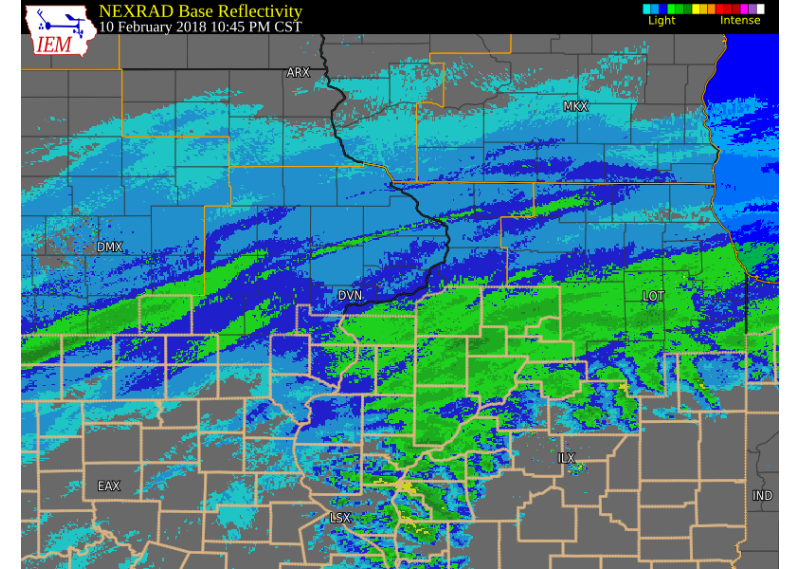
Snow fell over much of eastern Iowa, northwest Illinois, and northeast Missouri late Saturday and into Sunday morning, as an upper level storm system tracked east over the Great Plains. Snow covered roads and reduced visibilities were seen as the snow fell between 9 pm Saturday and 9 am Sunday. Snowfall totals between 1 and 3 inches were common, with a few locally higher amounts around 4 inches. The highest totals fell east of the Mississippi river in Knox, Henry, Bureau, and Putnam counties. National Weather Service Official Observations (event totals):
|
 Surface Map |
Storm Reports:
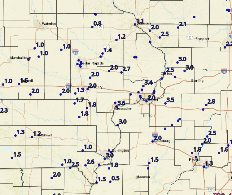 |
 |
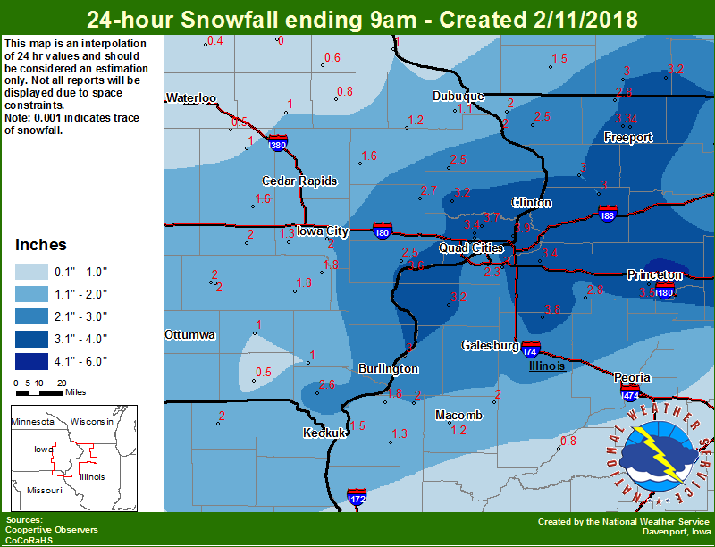 |
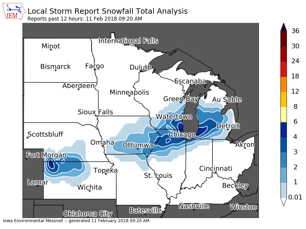
| Interactive Map Link | Iowa Snow Analysis Courtesy Iowa Environmental Mesonet |
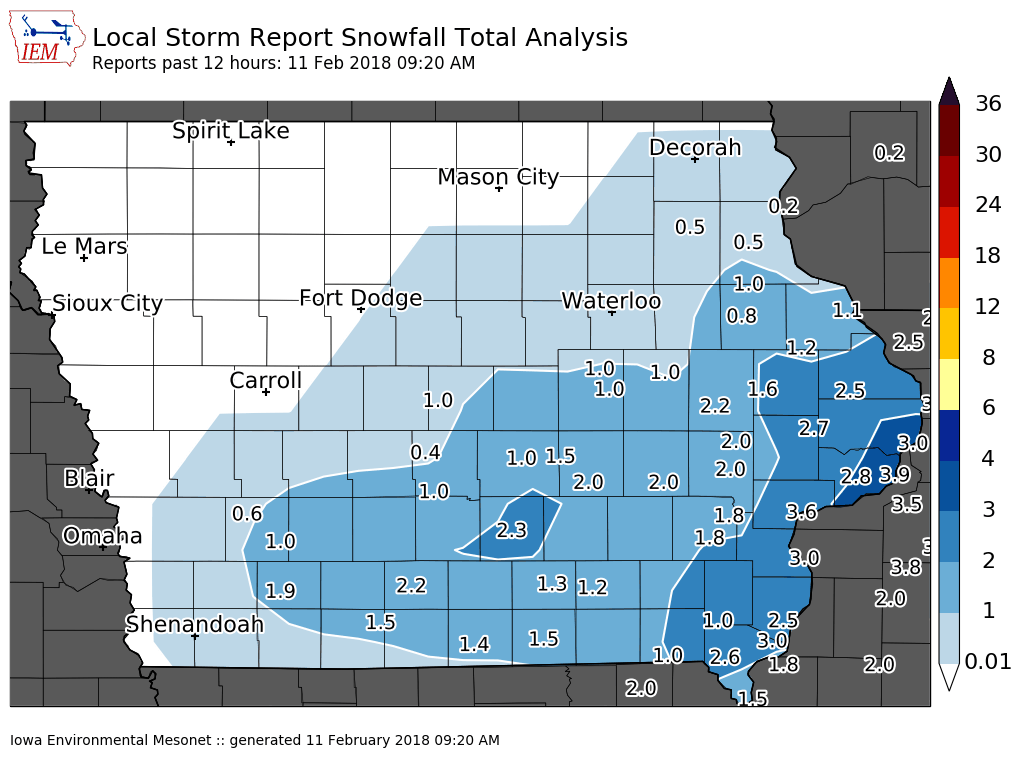
Local Snowfall |
 |
 |
|
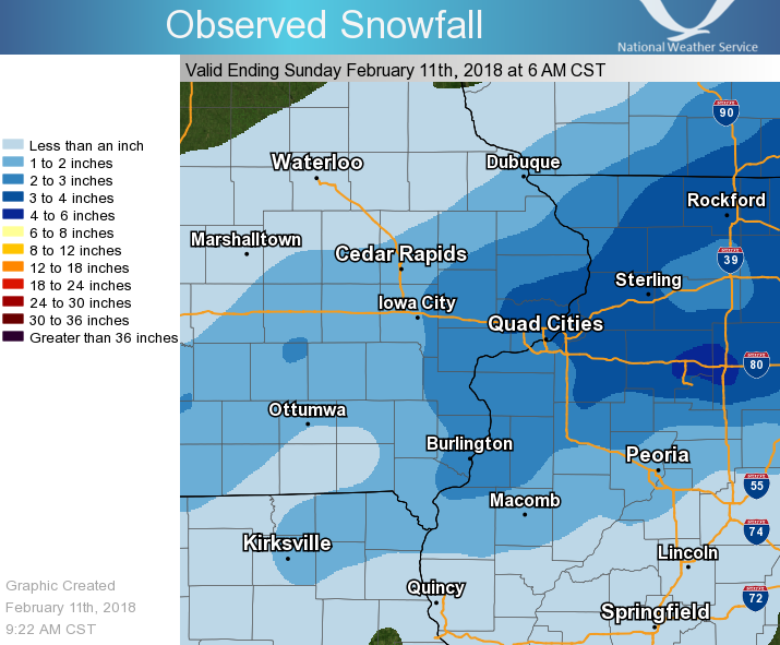
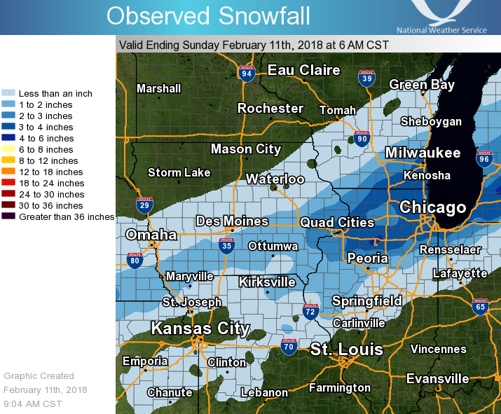
| Regional Snowfall | Midwest Snowfall |
PRELIMINARY LOCAL STORM REPORT...SUMMARY
NATIONAL WEATHER SERVICE QUAD CITIES IA IL
1027 AM CST SUN FEB 11 2018
..TIME... ...EVENT... ...CITY LOCATION... ...LAT.LON...
..DATE... ....MAG.... ..COUNTY LOCATION..ST.. ...SOURCE....
..REMARKS..
0700 AM SNOW PRINCETON 41.38N 89.48W
02/11/2018 M4.5 INCH BUREAU IL CO-OP OBSERVER
CO-OP OBSERVER STATION PTNI2, PRINCETON.
0958 AM SNOW 3 SSW BURLINGTON 40.77N 91.14W
02/11/2018 M4.0 INCH DES MOINES IA TRAINED SPOTTER
OVERNIGHT TOTAL.
0958 AM SNOW 1 E CLINTON 41.84N 90.22W
02/11/2018 M4.0 INCH CLINTON IA TRAINED SPOTTER
OVERNIGHT TOTAL.
0958 AM SNOW 4 ENE FREEPORT 42.32N 89.57W
02/11/2018 M4.0 INCH STEPHENSON IL TRAINED SPOTTER
OVERNIGHT TOTAL.
0645 AM SNOW 1 W PORT BYRON 41.62N 90.35W
02/11/2018 M3.9 INCH SCOTT IA COCORAHS
COCORAHS STATION IA-ST-1, 1 W PORT BYRON.
0821 AM SNOW 1 SSW KEWANEE 41.23N 89.93W
02/11/2018 E3.8 INCH HENRY IL TRAINED SPOTTER
0958 AM SNOW 1 NNE FREEPORT 42.30N 89.62W
02/11/2018 E3.8 INCH STEPHENSON IL TRAINED SPOTTER
OVERNIGHT TOTAL.
0600 AM SNOW ILLINOIS CITY L/D 16 41.42N 91.02W
02/11/2018 M3.6 INCH ROCK ISLAND IL CO-OP OBSERVER
CO-OP OBSERVER STATION ILNI2, ILLINOIS CITY
L/D 16.
0700 AM SNOW 2 N TISKILWA 41.32N 89.50W
02/11/2018 M3.5 INCH BUREAU IL COCORAHS
COCORAHS STATION IL-BU-8, 2 N TISKILWA.
0713 AM SNOW 1 N GENESEO 41.46N 90.15W
02/11/2018 M3.5 INCH HENRY IL TRAINED SPOTTER
SNOWFALL SINCE LAST EVENING.
0820 AM SNOW SE GALVA 41.17N 90.04W
02/11/2018 M3.5 INCH HENRY IL TRAINED SPOTTER
0927 AM SNOW LE CLAIRE 41.60N 90.36W
02/11/2018 E3.5 INCH SCOTT IA PUBLIC
OVERNIGHT SNOW TOTAL.
0953 AM SNOW GARDEN PLAIN 41.80N 90.13W
02/11/2018 E3.5 INCH WHITESIDE IL PUBLIC
OVERNIGHT SNOW TOTAL.
0955 AM SNOW FREEPORT 42.29N 89.63W
02/11/2018 E3.5 INCH STEPHENSON IL PUBLIC
OVERNIGHT SNOW TOTAL.
0634 AM SNOW PARK VIEW 41.69N 90.54W
02/11/2018 M3.4 INCH SCOTT IA NWS EMPLOYEE
OVERNIGHT TOTAL.
0730 AM SNOW 1 NW GENESEO 41.47N 90.18W
02/11/2018 M3.4 INCH HENRY IL COCORAHS
COCORAHS STATION IL-HY-8, 1 NW GENESEO.
0821 AM SNOW ELDRIDGE 41.64N 90.57W
02/11/2018 M3.4 INCH SCOTT IA NWS EMPLOYEE
OVERNIGHT TOTAL.
0958 AM SNOW ALEDO 41.20N 90.75W
02/11/2018 M3.2 INCH MERCER IL CO-OP OBSERVER
OVERNIGHT TOTAL.
0700 AM SNOW 2 WSW CHADWICK 42.00N 89.94W
02/11/2018 M3.0 INCH CARROLL IL COCORAHS
COCORAHS STATION IL-CR-4, 2 WSW CHADWICK.
0700 AM SNOW 1 SW COLETA 41.89N 89.81W
02/11/2018 M3.0 INCH WHITESIDE IL COCORAHS
COCORAHS STATION IL-WD-8, 1 SW COLETA.
0700 AM SNOW 2 SSE DAVENPORT 41.53N 90.59W
02/11/2018 M3.0 INCH SCOTT IA COCORAHS
COCORAHS STATION IA-ST-4, 2 SSE DAVENPORT.
0730 AM SNOW 2 NNW DAVENPORT 41.58N 90.62W
02/11/2018 M3.0 INCH SCOTT IA COCORAHS
COCORAHS STATION IA-ST-31, 2 NNW DAVENPORT.
0733 AM SNOW ALBANY 41.79N 90.22W
02/11/2018 E3.0 INCH WHITESIDE IL PUBLIC
VIA TWITTER.
0821 AM SNOW 1 WNW MORRISON 41.81N 89.98W
02/11/2018 M3.0 INCH WHITESIDE IL TRAINED SPOTTER
OVERNIGHT TOTAL.
0844 AM SNOW BURLINGTON 40.81N 91.12W
02/11/2018 E3.0 INCH DES MOINES IA PUBLIC
OVERNIGHT SNOW TOTAL.
0844 AM SNOW NEW BOSTON 41.17N 91.00W
02/11/2018 E3.0 INCH MERCER IL PUBLIC
OVERNIGHT SNOW TOTAL.
0855 AM SNOW WEVER 40.72N 91.23W
02/11/2018 E3.0 INCH LEE IA PUBLIC
OVERNIGHT SNOW TOTAL.
0700 AM SNOW 1 E KEWANEE 41.25N 89.90W
02/11/2018 M2.8 INCH HENRY IL CO-OP OBSERVER
CO-OP OBSERVER STATION KEWI2, 1 E KEWANEE.
0812 AM SNOW 5 NNE PRINCETON 41.44N 89.43W
02/11/2018 M2.8 INCH BUREAU IL TRAINED SPOTTER
OVERNIGHT SNOW TOTAL.
0821 AM SNOW 4 NNW DAVENPORT 41.61N 90.63W
02/11/2018 M2.8 INCH SCOTT IA NWS EMPLOYEE
OVERNIGHT TOTAL.
0700 AM SNOW 1 SE DAVENPORT 41.54N 90.59W
02/11/2018 M2.7 INCH SCOTT IA COCORAHS
COCORAHS STATION IA-ST-37, 1 SE DAVENPORT.
0700 AM SNOW 1 SE DAVENPORT 41.54N 90.59W
02/11/2018 M2.7 INCH SCOTT IA COCORAHS
COCORAHS STATION IA-ST-37, 1 SE DAVENPORT.
0700 AM SNOW LOWDEN 41.87N 90.93W
02/11/2018 M2.7 INCH CEDAR IA CO-OP OBSERVER
CO-OP OBSERVER STATION LWDI4, LOWDEN.
0700 AM SNOW DONNELLSON 40.63N 91.57W
02/11/2018 M2.6 INCH LEE IA CO-OP OBSERVER
CO-OP OBSERVER STATION DNNI4, DONNELLSON.
0610 AM SNOW DAVENPORT 41.56N 90.60W
02/11/2018 M2.5 INCH SCOTT IA OFFICIAL NWS OBS
SNOWFALL SINCE LAST EVENING. SNOW DEPTH 9
INCHES. AT THE NATIONAL WEATHER SERVICE
OFFICE AT THE DAVENPORT AIRPORT.
0630 AM SNOW ELIZABETH 42.33N 90.25W
02/11/2018 M2.5 INCH JO DAVIESS IL CO-OP OBSERVER
CO-OP OBSERVER STATION EZBI2, ELIZABETH.
0700 AM SNOW 4 W MAQUOKETA 42.07N 90.70W
02/11/2018 M2.5 INCH JACKSON IA CO-OP OBSERVER
CO-OP OBSERVER STATION MKTI4, 4 W MAQUOKETA.
0700 AM SNOW 2 N MUSCATINE 41.47N 91.04W
02/11/2018 M2.5 INCH MUSCATINE IA CO-OP OBSERVER
CO-OP OBSERVER STATION MSTI4, 2 N MUSCATINE.
0733 AM SNOW 4 ENE CLINTON 41.86N 90.16W
02/11/2018 M2.5 INCH WHITESIDE IL TRAINED SPOTTER
OVERNIGHT TOTAL.
0825 AM SNOW 3 ENE CHARLIE HEATH MEM 40.60N 91.84W
02/11/2018 E2.5 INCH CLARK MO TRAINED SPOTTER
EVENT TOTAL. SNOW DEPTH 4 INCHES.
0844 AM SNOW MAQUOKETA 42.07N 90.67W
02/11/2018 E2.5 INCH JACKSON IA PUBLIC
OVERNIGHT SNOW TOTAL.
0812 AM SNOW 1 S WALCOTT 41.58N 90.77W
02/11/2018 M2.4 INCH SCOTT IA TRAINED SPOTTER
OVERNIGHT SNOW TOTAL.
0747 AM SNOW 1 NE FORT MADISON 40.64N 91.33W
02/11/2018 E2.3 INCH LEE IA TRAINED SPOTTER
0953 AM SNOW 2 WSW IOWA CITY 41.65N 91.57W
02/11/2018 E2.3 INCH JOHNSON IA TRAINED SPOTTER
EVENT TOTAL.
0844 AM SNOW 2 NE CEDAR RAPIDS 41.99N 91.64W
02/11/2018 E2.2 INCH LINN IA PUBLIC
OVERNIGHT SNOW TOTAL.
0856 AM SNOW 1 ESE NORA 42.46N 89.93W
02/11/2018 E2.1 INCH JO DAVIESS IL TRAINED SPOTTER
OVERNIGHT SNOW TOTAL.
0600 AM SNOW BELLEVUE L/D 12 42.27N 90.42W
02/11/2018 M2.0 INCH JO DAVIESS IL MESONET
MESONET STATION BLVI4, BELLEVUE L/D 12.
0600 AM SNOW MEMPHIS 40.46N 92.17W
02/11/2018 M2.0 INCH SCOTLAND MO CO-OP OBSERVER
CO-OP OBSERVER STATION MMPM7, MEMPHIS.
0600 AM SNOW PRAIRIE CITY 40.59N 90.46W
02/11/2018 M2.0 INCH MCDONOUGH IL CO-OP OBSERVER
CO-OP OBSERVER STATION PRCI2, PRAIRIE CITY.
0610 AM SNOW MOLINE 41.49N 90.49W
02/11/2018 M2.0 INCH ROCK ISLAND IL OFFICIAL NWS OBS
SNOWFALL SINCE LAST EVENING. SNOW DEPTH 10
INCHES. AT THE QUAD CITY AIRPORT.
0655 AM SNOW E SOLON 41.80N 91.49W
02/11/2018 M2.0 INCH JOHNSON IA TRAINED SPOTTER
OVERNIGHT TOTAL.
0700 AM SNOW GALENA 42.42N 90.43W
02/11/2018 M2.0 INCH JO DAVIESS IL CO-OP OBSERVER
CO-OP OBSERVER STATION GPBI2, GALENA.
0700 AM SNOW IOWA CITY 41.65N 91.53W
02/11/2018 M2.0 INCH JOHNSON IA CO-OP OBSERVER
CO-OP OBSERVER STATION ICYI4, IOWA CITY.
0733 AM SNOW WNW PARNELL 41.58N 92.01W
02/11/2018 M2.0 INCH IOWA IA TRAINED SPOTTER
OVERNIGHT TOTAL.
0821 AM SNOW SE STANWOOD 41.89N 91.15W
02/11/2018 M2.0 INCH CEDAR IA TRAINED SPOTTER
OVERNIGHT TOTAL.
0945 AM SNOW 2 WNW BURLINGTON 40.82N 91.16W
02/11/2018 M2.0 INCH DES MOINES IA TRAINED SPOTTER
OVERNIGHT SNOW TOTAL.
0958 AM SNOW 2 NE MUSCATINE 41.44N 91.04W
02/11/2018 M2.0 INCH MUSCATINE IA TRAINED SPOTTER
OVERNIGHT TOTAL.
0958 AM SNOW 1 ESE NEW LONDON 40.92N 91.40W
02/11/2018 M1.9 INCH HENRY IA TRAINED SPOTTER
OVERNIGHT TOTAL.
0700 AM SNOW 2 NE COLUSA 40.59N 91.15W
02/11/2018 M1.8 INCH HANCOCK IL COCORAHS
COCORAHS STATION IL-HN-1, 2 NE COLUSA.
0700 AM SNOW 4 N HASKINS 41.40N 91.54W
02/11/2018 M1.8 INCH WASHINGTON IA COCORAHS
COCORAHS STATION IA-WS-2, 4 N HASKINS.
0700 AM SNOW WASHINGTON 41.28N 91.68W
02/11/2018 M1.8 INCH WASHINGTON IA CO-OP OBSERVER
CO-OP OBSERVER STATION WSHI4, WASHINGTON.
0700 AM SNOW 3 W RICHMOND 41.46N 91.76W
02/11/2018 M1.7 INCH WASHINGTON IA COCORAHS
COCORAHS STATION IA-WS-7, 3 W RICHMOND.
0700 AM SNOW 3 SSW ANAMOSA 42.08N 91.30W
02/11/2018 M1.6 INCH JONES IA CO-OP OBSERVER
CO-OP OBSERVER STATION AMOI4, 3 SSW ANAMOSA.
0600 AM SNOW KEOKUK L/D 19 40.40N 91.37W
02/11/2018 M1.5 INCH HANCOCK IL MESONET
MESONET STATION EOKI4, KEOKUK L/D 19.
0610 AM SNOW 1 SSE CEDAR RAPIDS 41.95N 91.66W
02/11/2018 M1.5 INCH LINN IA TRAINED SPOTTER
SNOWFALL SINCE LAST EVENING.
0740 AM SNOW 1 ENE ANAMOSA 42.12N 91.27W
02/11/2018 M1.4 INCH JONES IA TRAINED SPOTTER
OVERNIGHT TOTAL.
0700 AM SNOW 1 NNW WILLIAMSTOWN 41.59N 91.75W
02/11/2018 M1.3 INCH JOHNSON IA COCORAHS
COCORAHS STATION IA-JH-9, 1 NNW
WILLIAMSTOWN.
0914 AM SNOW 2 W CEDAR RAPIDS 41.98N 91.71W
02/11/2018 M1.3 INCH LINN IA TRAINED SPOTTER
OVERNIGHT SNOW TOTAL.
0958 AM SNOW 1 SE VINTON 42.16N 92.02W
02/11/2018 M1.3 INCH BENTON IA TRAINED SPOTTER
OVERNIGHT TOTAL.
0610 AM SNOW CEDAR RAPIDS 41.97N 91.67W
02/11/2018 M1.2 INCH LINN IA BROADCAST MEDIA
AT KCRG-TV IN DOWNTOWN CEDAR RAPIDS.
0700 AM SNOW CASCADE 42.30N 91.02W
02/11/2018 M1.2 INCH DUBUQUE IA CO-OP OBSERVER
CO-OP OBSERVER STATION CASI4, CASCADE.
0733 AM SNOW 2 NNE CEDAR RAPIDS 42.01N 91.65W
02/11/2018 M1.2 INCH LINN IA TRAINED SPOTTER
OVERNIGHT TOTAL.
0927 AM SNOW 4 NNW CEDAR RAPIDS 42.03N 91.69W
02/11/2018 M1.2 INCH LINN IA TRAINED SPOTTER
OVERNIGHT SNOW TOTAL.
0610 AM SNOW DUBUQUE 42.50N 90.69W
02/11/2018 M1.1 INCH DUBUQUE IA OFFICIAL NWS OBS
SNOWFALL SINCE LAST EVENING. SNOW DEPTH 10
INCHES. AT THE DUBUQUE REGIONAL AIRPORT.
0700 AM SNOW SALEM 1 S 40.83N 91.62W
02/11/2018 M1.0 INCH HENRY IA CO-OP OBSERVER
CO-OP OBSERVER STATION SLHI4, SALEM 1 S.
0700 AM SNOW VINTON 42.17N 92.00W
02/11/2018 M1.0 INCH BENTON IA CO-OP OBSERVER
CO-OP OBSERVER STATION VNTI4, VINTON.
0755 AM SNOW EDGEWOOD 42.64N 91.40W
02/11/2018 M1.0 INCH DELAWARE IA TRAINED SPOTTER
0820 AM SNOW 1 NNW EDGEWOOD 42.63N 91.39W
02/11/2018 E1.0 INCH DELAWARE IA TRAINED SPOTTER
OVERNIGHT TOTAL.
0918 AM SNOW 5 E CANTRIL 40.64N 91.98W
02/11/2018 E1.0 INCH VAN BUREN IA TRAINED SPOTTER
EVENT TOTAL. SNOW DEPTH 2.5 INCHES.
0700 AM SNOW MANCHESTER 42.47N 91.45W
02/11/2018 M0.8 INCH DELAWARE IA CO-OP OBSERVER
CO-OP OBSERVER STATION MHRI4, MANCHESTER.
0655 AM SNOW ESE CARTHAGE 40.41N 91.13W
02/11/2018 M0.5 INCH HANCOCK IL TRAINED SPOTTER
OVERNIGHT TOTAL.
Environment:
 |
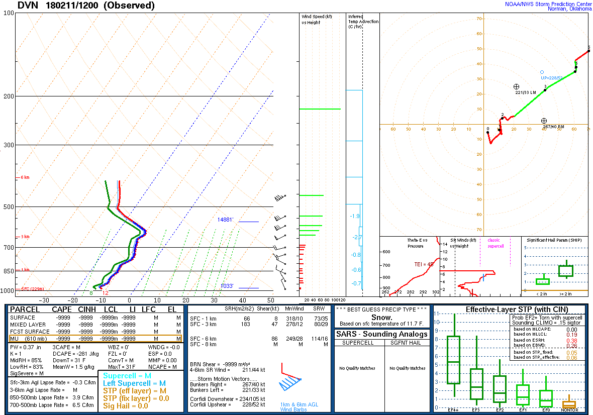 |
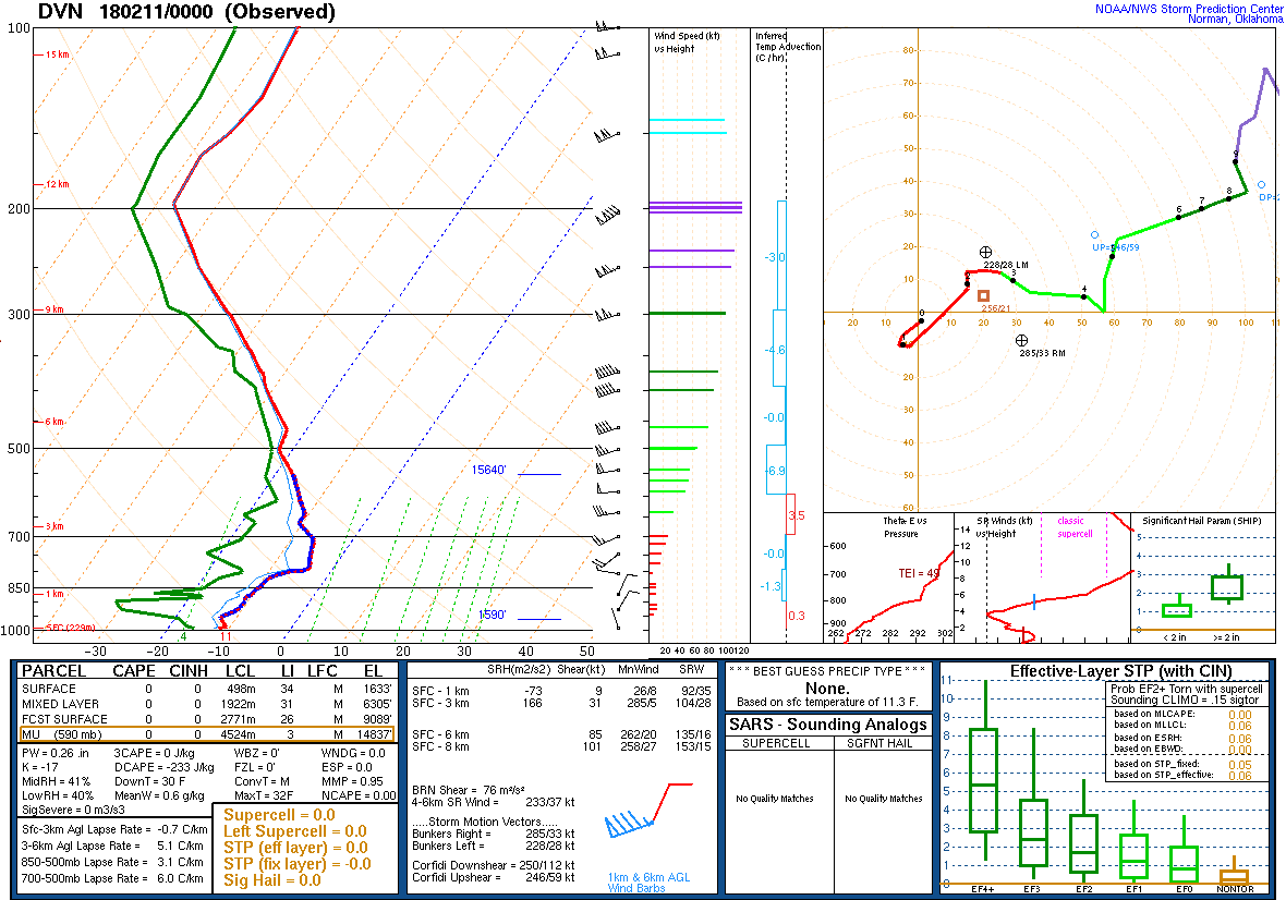
| Figure 1: 00Z 2/11 DVN Sounding | Figure 2: 12z 2/11 Sounding |
 |
Media use of NWS Web News Stories is encouraged! Please acknowledge the NWS as the source of any news information accessed from this site. |
|