Overview
|
Fast moving severe thunderstorms developed and tracked over much of eastern Iowa, northwest Illinois, and northeast Missouri on Wednesday, May 17, 2017, as an area of low pressure lifted northeast into northwest Iowa. Widespread damaging winds, large hail, frequent lightning, and a few brief tornadoes were reported. |
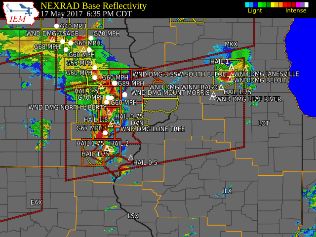
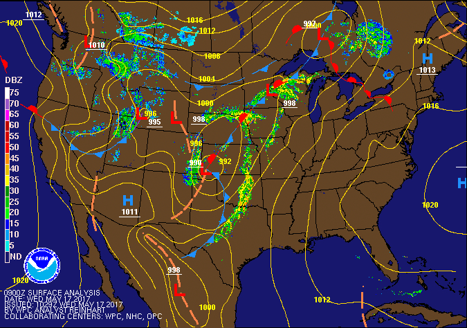 Surface Map/Radar Loop |
Tornadoes:
| Damage Survey Viewer | ||||||||||||||||
|
Tornado 1 - Hooppole, IL
Track Map 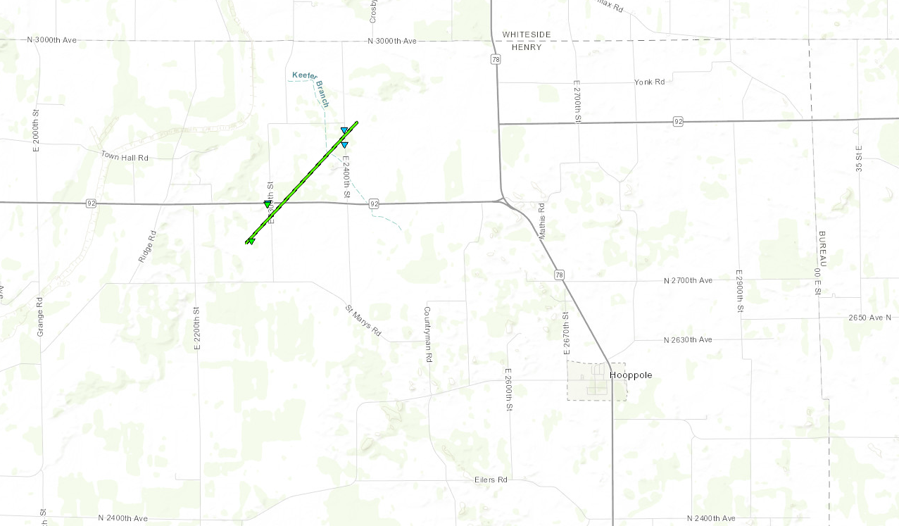  |
||||||||||||||||
|
Tornado 2 - Sherrard, IL
Track Map 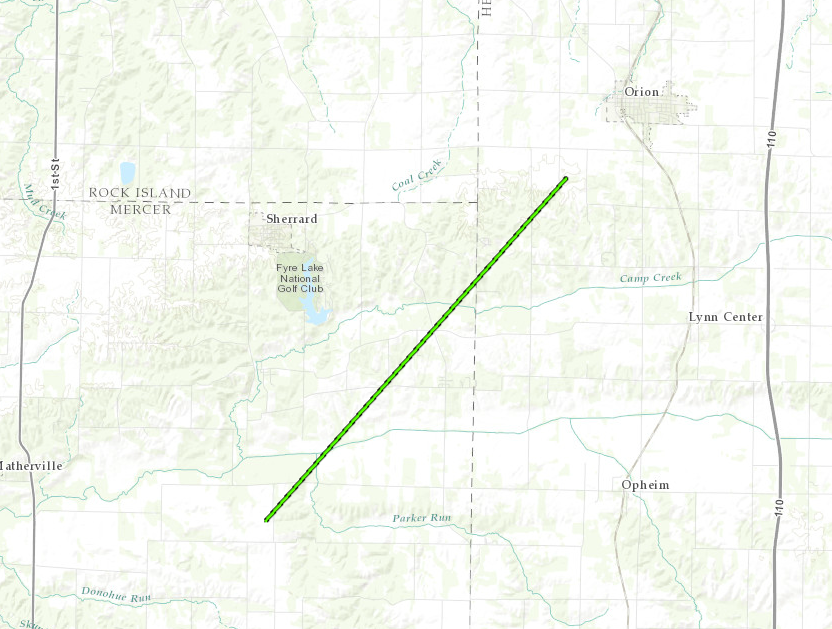 |
||||||||||||||||
|
Tornado 3 - Galva, IL
Track Map 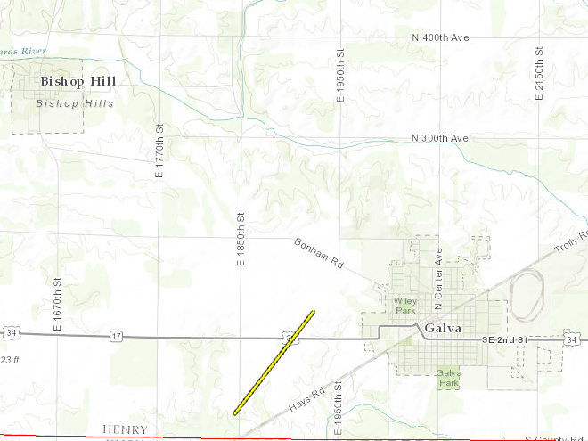 |
||||||||||||||||
|
Tornado 4 - Lake Darling State Park, IA
Track Map 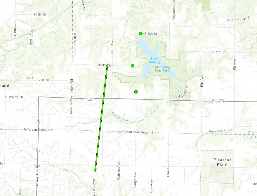 |
||||||||||||||||
|
Tornado 5 - Riverside, IA
Track Map .PNG) |
||||||||||||||||
|
Tornado 6 - 5 SSE Muscatine, IA in Illinois
Track Map 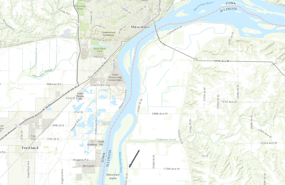 |
||||||||||||||||
|
Tornado 7 - Donahue, IA
Track Map 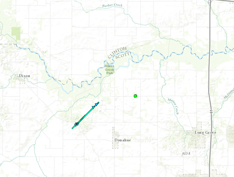 |
||||||||||||||||
The Enhanced Fujita (EF) Scale classifies tornadoes into the following categories:
| EF0 Weak 65-85 mph |
EF1 Moderate 86-110 mph |
EF2 Significant 111-135 mph |
EF3 Severe 136-165 mph |
EF4 Extreme 166-200 mph |
EF5 Catastrophic 200+ mph |
 |
|||||
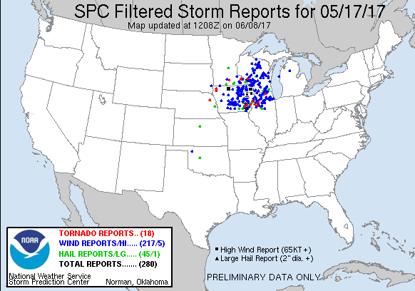
Storm Reports
| Interactive Storm Report Map | SPC Storm Reports |
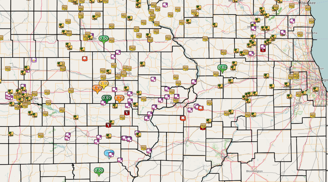 |
 |
PRELIMINARY LOCAL STORM REPORT...SUMMARY
NATIONAL WEATHER SERVICE QUAD CITIES IA IL
..TIME... ...EVENT... ...CITY LOCATION... ...LAT.LON...
..DATE... ....MAG.... ..COUNTY LOCATION..ST.. ...SOURCE....
..REMARKS..
0250 PM HAIL MARENGO 41.80N 92.07W
05/17/2017 M0.25 INCH IOWA IA EMERGENCY MNGR
0300 PM NON-TSTM WND GST MIDDLETOWN 40.83N 91.26W
05/17/2017 E65.00 MPH DES MOINES IA TRAINED SPOTTER
0312 PM HAIL URBANA 42.22N 91.88W
05/17/2017 M0.50 INCH BENTON IA EMERGENCY MNGR
0340 PM NON-TSTM WND DMG DAVENPORT 41.56N 90.60W
05/17/2017 SCOTT IA TRAINED SPOTTER
TREE DAMAGED BY VANDER VEER PARK
0345 PM NON-TSTM WND DMG N WEST LIBERTY 41.58N 91.26W
05/17/2017 MUSCATINE IA TRAINED SPOTTER
9-12 INCH DIAMETER LIMBS DOWN NEAR COLUMBUS AVE
0345 PM HEAVY RAIN KEOSAUQUA 40.73N 91.96W
05/17/2017 E0.00 INCH VAN BUREN IA TRAINED SPOTTER
VERY HEAVY RAIN - VISIBILITIES REDUCED SIGNIFICANTLY
0356 PM HAIL FARMINGTON 40.64N 91.74W
05/17/2017 E0.25 INCH VAN BUREN IA FIRE DEPT/RESCUE
TIME ESTIMATED - PEA TO DIME SIZE HAIL DURING STORM
0356 PM TSTM WND DMG FARMINGTON 40.64N 91.74W
05/17/2017 VAN BUREN IA FIRE DEPT/RESCUE
BRANCHES DOWN
0410 PM TSTM WND GST FAIRFIELD 41.01N 91.97W
05/17/2017 M55.00 MPH JEFFERSON IA AWOS
0411 PM HAIL 1 NNW MOUNT PLEASANT 40.97N 91.56W
05/17/2017 M0.25 INCH HENRY IA TRAINED SPOTTER
PEA TO DIME SIZE HAIL
0411 PM TSTM WND DMG FAIRFIELD 41.01N 91.97W
05/17/2017 JEFFERSON IA TRAINED SPOTTER
2 SEMIS ON HWY 34 BLOWN OVER
0416 PM TORNADO 4 W PLEASANT PLAIN 41.15N 91.93W
05/17/2017 F1 JEFFERSON IA NWS STORM SURVEY
A RAPIDLY MOVING EF-1 TORNADO MOVED ALMOST DUE NORTH FROM
ABOUT 4 MILES WEST OF PLEASANT PLAIN IN JEFFERSON COUNTY
TO ABOUT 1.5 MILES WEST OF LAKE DARLING STATE PARK IN
WASHINGTON COUNTY DAMAGING FARM OUTBUILDINGS AND TREES.
ESTIMATED PEAK WINDS WERE 110 MPH. PATH LENGTH WAS 3.27
MILES. MAXIMUM PATH WIDTH WAS 25 YARDS. IT LASTED FOR
ABOUT 4 MINUTES.
0420 PM TSTM WND DMG 1 E RUBIO 41.22N 91.91W
05/17/2017 WASHINGTON IA TRAINED SPOTTER
TIME ESTIMATED - SEVERAL TREES DAMAGED. BOARDS BLOWN OFF
RAILROAD WALKWAY, GROUND COVERED WITH LEAVES
0420 PM TORNADO 1 ESE RICHLAND 41.18N 91.98W
05/17/2017 KEOKUK IA FIRE DEPT/RESCUE
TORNADO MOVED NORTHEAST INTO WASHINGTON COUNTY.
0420 PM HAIL MOUNT PLEASANT 40.96N 91.55W
05/17/2017 E0.50 INCH HENRY IA TRAINED SPOTTER
0420 PM HAIL MOUNT PLEASANT 40.96N 91.55W
05/17/2017 E1.75 INCH HENRY IA BROADCAST MEDIA
VIA SOCIAL MEDIA - TIME ESTIMATED
0420 PM TSTM WND DMG WELLMAN 41.47N 91.84W
05/17/2017 WASHINGTON IA LAW ENFORCEMENT
TIME ESTIMATED - OUTBUILDINGS, SHED, WINDOWS AND ROOFS
DAMAGED
0421 PM HAIL 1 SW DYERSVILLE 42.47N 91.13W
05/17/2017 M1.00 INCH DUBUQUE IA TRAINED SPOTTER
0428 PM HAIL MOUNT UNION 41.06N 91.39W
05/17/2017 M1.25 INCH HENRY IA EMERGENCY MNGR
0430 PM TSTM WND DMG 2 W YARMOUTH 41.03N 91.36W
05/17/2017 DES MOINES IA TRAINED SPOTTER
TIME IS ESTIMATED - LARGE TREE BRANCH APPROX 18 FEET LONG
WAS TORN OFF TREE
0440 PM TSTM WND DMG WELLMAN 41.47N 91.84W
05/17/2017 WASHINGTON IA LAW ENFORCEMENT
ROOF OFF A SHED, A GARAGE, A HOG BUILDING AND A HORSE
SHED. ANOTHER GARAGE TORN OFF A HOUSE. TREES AND POWER
LINES DOWN. LARGE TREE DOWN ON A ROAD. TIME ESTIMATED BY
RADAR.
0452 PM HAIL SSE GRANDVIEW 41.28N 91.19W
05/17/2017 M1.00 INCH LOUISA IA TRAINED SPOTTER
DELAYED REPORT, TIME ESTIMATED
0454 PM HAIL 3 W OXFORD 41.72N 91.85W
05/17/2017 M0.50 INCH IOWA IA TRAINED SPOTTER
PEA TO DIMES
0504 PM TORNADO 5 SSE MUSCATINE 41.35N 91.05W
05/17/2017 ROCK ISLAND IL STORM CHASER
SHORT-LIVED EF0 TORNADO WAS OBSERVED BY A STORM CHASER.
VIDEO EVIDENCE OF THE CIRCULATION DETAILED A TORNADO THAT
LASTED AROUND A MIN. NO DAMAGE WAS OBSERVED. THE PEAK
WINDS WERE ESTIMATED AROUND 70 MPH.
0511 PM HAIL 3 NE MUSCATINE 41.46N 91.03W
05/17/2017 M1.00 INCH MUSCATINE IA TRAINED SPOTTER
0514 PM HAIL 3 NE MUSCATINE 41.45N 91.04W
05/17/2017 M0.88 INCH MUSCATINE IA TRAINED SPOTTER
0523 PM HAIL 3 S DURANT 41.56N 90.91W
05/17/2017 M1.75 INCH MUSCATINE IA TRAINED SPOTTER
0531 PM NON-TSTM WND DMG 1 E WYANET 41.36N 89.56W
05/17/2017 BUREAU IL TRAINED SPOTTER
DUST STORM ALONG ROUTE 6 - TRAFFIC BACKED UP DUE TO
ACCIDENTS
0536 PM TSTM WND DMG ROCK FALLS 41.77N 89.69W
05/17/2017 WHITESIDE IL BROADCAST MEDIA
TREE BLOWN ONTO HOME ON 6TH AVE. RELAYED BY KWQC. TIME
ESTIMATED ON RADAR.
0540 PM HAIL 1 S DIXON 41.73N 90.78W
05/17/2017 E1.00 INCH SCOTT IA TRAINED SPOTTER
MIX OF DIME TO QUARTER SIZE HAIL.
0542 PM TSTM WND GST MARENGO 41.80N 92.07W
05/17/2017 M60.00 MPH IOWA IA TRAINED SPOTTER
RELAYED FROM DSM
0542 PM TSTM WND DMG MARENGO 41.80N 92.07W
05/17/2017 IOWA IA TRAINED SPOTTER
RELAYED FROM DSM - LARGE TREE DOWN
0546 PM TSTM WND GST BLAIRSTOWN 41.91N 92.08W
05/17/2017 M70.00 MPH BENTON IA EMERGENCY MNGR
0548 PM HEAVY RAIN MEMPHIS 40.46N 92.17W
05/17/2017 E0.50 INCH SCOTLAND MO LAW ENFORCEMENT
RAIN FELL WITHIN 15 MINUTES - WATER GUSHING OUT OF FIELDS
IS CAUSING TRAFFIC PROBLEMS
0552 PM HAIL S NORTH ENGLISH 41.52N 92.08W
05/17/2017 M1.00 INCH IOWA IA PUBLIC
ALSO REPORTING WINDS UP TO 55 MPH AND HEAVY RAIN.
0552 PM HAIL BATAVIA 40.99N 92.17W
05/17/2017 E1.75 INCH JEFFERSON IA TRAINED SPOTTER
HAIL LASTED 10 MINUTES AND IS COVERING THE GROUND
0553 PM TSTM WND GST VAN HORNE 42.01N 92.09W
05/17/2017 M70.00 MPH BENTON IA EMERGENCY MNGR
0557 PM TSTM WND DMG NEWHALL 41.99N 91.97W
05/17/2017 BENTON IA PUBLIC
ROOF BLOWN OFF HOME, PICTURE FROM TWITTER
0600 PM HAIL FAIRFAX 41.92N 91.78W
05/17/2017 E0.50 INCH LINN IA COCORAHS
1 INCH DEEP - MINOR LEAF DAMAGE
0605 PM TSTM WND DMG E FREEPORT 42.29N 89.63W
05/17/2017 STEPHENSON IL LAW ENFORCEMENT
LARGE TREE BLOWN DOWN BLOCKING ROAD ON EAST SIDE OF
FREEPORT.
0608 PM TSTM WND GST SHELLSBURG 42.09N 91.87W
05/17/2017 E70.00 MPH BENTON IA TRAINED SPOTTER
0610 PM TSTM WND GST FAIRFAX 41.92N 91.78W
05/17/2017 E70.00 MPH LINN IA EMERGENCY MNGR
0615 PM TSTM WND GST JESUP 42.48N 92.07W
05/17/2017 E65.00 MPH BUCHANAN IA PUBLIC
0615 PM TSTM WND GST 2 SSW LADORA 41.73N 92.20W
05/17/2017 M70.00 MPH IOWA IA TRAINED SPOTTER
0615 PM HEAVY RAIN JESUP 42.48N 92.07W
05/17/2017 E0.50 INCH BUCHANAN IA PUBLIC
RAIN FELL WITHIN 10 MINUTES
0616 PM HEAVY RAIN 2 SSW LADORA 41.73N 92.20W
05/17/2017 M1.70 INCH IOWA IA TRAINED SPOTTER
FALLEN OVER THE PAST 20 MINUTES
0616 PM TSTM WND GST CEDAR RAPIDS 41.97N 91.67W
05/17/2017 M54.00 MPH LINN IA ASOS
0617 PM HAIL 2 ESE KEOSAUQUA 40.72N 91.92W
05/17/2017 M1.00 INCH VAN BUREN IA TRAINED SPOTTER
HAIL LASTED FOR A MINUTE
0620 PM TSTM WND DMG NORTH LIBERTY 41.74N 91.61W
05/17/2017 JOHNSON IA PUBLIC
TREE BLOWN OVER, TIME ESTIMATED.
0621 PM HAIL WALKER 42.29N 91.78W
05/17/2017 E0.50 INCH LINN IA PUBLIC
PEA SIZE AND LARGER
0621 PM TSTM WND GST 1 SSE CEDAR RAPIDS 41.95N 91.66W
05/17/2017 M70.00 MPH LINN IA TRAINED SPOTTER
0627 PM TSTM WND GST 5 NNE CEDAR RAPIDS 42.05N 91.63W
05/17/2017 M60.00 MPH LINN IA TRAINED SPOTTER
0628 PM TSTM WND GST 1 W RYAN 42.35N 91.50W
05/17/2017 M89.00 MPH DELAWARE IA FIRE DEPT/RESCUE
0628 PM TSTM WND GST 2 ENE MARION 42.04N 91.56W
05/17/2017 E70.00 MPH LINN IA TRAINED SPOTTER
WIND ESTIMATED 60 - 70 MPH RAIN IS HORIZONTAL
0630 PM TSTM WND GST 1 WNW INDEPENDENCE 42.47N 91.91W
05/17/2017 M50.00 MPH BUCHANAN IA TRAINED SPOTTER
0632 PM TSTM WND GST RYAN 42.35N 91.48W
05/17/2017 M60.00 MPH DELAWARE IA EMERGENCY MNGR
0635 PM TSTM WND GST WASHINGTON 41.30N 91.69W
05/17/2017 M67.00 MPH WASHINGTON IA AWOS
0636 PM TORNADO 7 NE WASHINGTON 41.37N 91.60W
05/17/2017 WASHINGTON IA NWS STORM SURVEY
AN EF-1 TORNADO SPUN UP AND TRACKED RAPIDLY TO THE
NORTHEAST. THE TORNADO DAMAGED NUMEROUS FARM
OUTBUILDINGS, POWER LINES, AND TREES ALONG THE PATH. THE
PEAK WIND SPEED WAS 110 MPH WITH A PATH LENGTH OF 5.95
MILES AND A MAX WIDTH OF 40 YARDS.
0637 PM HAIL 5 WNW MOUNT PLEASANT 40.98N 91.64W
05/17/2017 E2.00 INCH HENRY IA PUBLIC
0637 PM HAIL 1 E ROME 40.98N 91.66W
05/17/2017 M1.75 INCH HENRY IA AMATEUR RADIO
0640 PM HAIL NW MOUNT PLEASANT 40.96N 91.55W
05/17/2017 M1.75 INCH HENRY IA 911 CALL CENTER
0640 PM TSTM WND GST ANAMOSA 42.11N 91.28W
05/17/2017 M58.00 MPH JONES IA MESONET
RWIS REPORT NEAR HWY 151.
0645 PM TSTM WND DMG ANAMOSA 42.11N 91.28W
05/17/2017 JONES IA EMERGENCY MNGR
TIME APPROXIMATE - TREE ON HOUSE
0646 PM HAIL SW RIVERSIDE 41.48N 91.58W
05/17/2017 M1.50 INCH WASHINGTON IA TRAINED SPOTTER
0648 PM HAIL 2 SSE HILLS 41.55N 91.53W
05/17/2017 E0.75 INCH JOHNSON IA TRAINED SPOTTER
PEA SIZE AND LARGER
0648 PM TSTM WND DMG LONE TREE 41.49N 91.42W
05/17/2017 JOHNSON IA EMERGENCY MNGR
PARKED SEMI BLOWN OVER AND DAMAGE TO FARM OUTBUILDINGS.
POWER POLES DOWN. STRAIGHT LINE WIND DAMAGE.
0649 PM TSTM WND DMG LONE TREE 41.49N 91.42W
05/17/2017 JOHNSON IA EMERGENCY MNGR
BARN BLOWN DOWN IN LONE TREE ON 640TH AND SOO, REPORTED
BY SHERIFFS DEPUTY TO EM. TIME ESTIMATED
0649 PM HAIL 2 SW BURLINGTON 40.78N 91.15W
05/17/2017 M0.50 INCH DES MOINES IA TRAINED SPOTTER
0651 PM TSTM WND GST ONEIDA 42.54N 91.35W
05/17/2017 E75.00 MPH DELAWARE IA EMERGENCY MNGR
0652 PM TSTM WND GST 1 S EDGEWOOD 42.63N 91.40W
05/17/2017 E70 MPH DELAWARE IA TRAINED SPOTTER
TIME ESTIMATED BASED ON RADAR.
0657 PM TSTM WND GST SW DYERSVILLE 42.48N 91.12W
05/17/2017 M72.00 MPH DUBUQUE IA EMERGENCY MNGR
0657 PM HAIL IOWA CITY 41.66N 91.54W
05/17/2017 E0.25 INCH JOHNSON IA PUBLIC
0659 PM TSTM WND DMG WEST BRANCH 41.67N 91.35W
05/17/2017 CEDAR IA PUBLIC
60 FOOT TREE THROUGH A GARAGE IN TOWN.
0700 PM TSTM WND DMG 2 WSW NEW VIENNA 42.54N 91.16W
05/17/2017 DELAWARE IA TRAINED SPOTTER
SEVERAL FARM BUILDINGS DAMAGED NEAR DYERSVILLE
0704 PM TSTM WND GST HOLY CROSS 42.60N 91.00W
05/17/2017 M78.00 MPH DUBUQUE IA EMERGENCY MNGR
0713 PM HEAVY RAIN 1 NW WILLIAMSTOWN 41.58N 91.75W
05/17/2017 M1.75 INCH JOHNSON IA TRAINED SPOTTER
RAIN IN 20 MINUTES.
0718 PM HAIL WSW CLARENCE 41.88N 91.06W
05/17/2017 E0.25 INCH CEDAR IA TRAINED SPOTTER
HAIL AND VERY STRONG WIND
0719 PM HEAVY RAIN WNW PARNELL 41.58N 92.01W
05/17/2017 M0.97 INCH IOWA IA TRAINED SPOTTER
DAILY TOTAL - 0.90 IN PAST HOUR
0720 PM TSTM WND DMG ASBURY 42.51N 90.76W
05/17/2017 DUBUQUE IA TRAINED SPOTTER
TREE SPLIT IN HALF AT CORNER OF SUN VALLEY DR AND SPRING
GREEN ST. ALSO SEVERAL BRANCHES DOWN.
0720 PM TSTM WND GST ASBURY 42.51N 90.76W
05/17/2017 M60.00 MPH DUBUQUE IA TRAINED SPOTTER
0734 PM HAIL FRUITLAND 41.35N 91.13W
05/17/2017 M1.00 INCH MUSCATINE IA PUBLIC
PICTURE FROM TWITTER, TIME ESTIMATED.
0734 PM HEAVY RAIN MARENGO 41.80N 92.07W
05/17/2017 E1.10 INCH IOWA IA TRAINED SPOTTER
WATER STANDING IN THE STREETS
0740 PM HAIL SSE GRANDVIEW 41.28N 91.19W
05/17/2017 E1.75 INCH LOUISA IA TRAINED SPOTTER
0744 PM TORNADO 3 WNW DONAHUE 41.70N 90.72W
05/17/2017 F0 SCOTT IA NWS STORM SURVEY
A SQUALL LINE TORNADO CAUSED SPORADIC EF-0 DAMAGE ALONG
ITS TWO MILE PATH. NUMEROUS TREES WERE DAMAGED WITH A FEW
ROTTEN TREES SNAPPED. ROOFING DAMAGE TO A NEW HOME AND
GARAGE WERE NOTED AT THE BEGINNING OF THE PATH. THE PEAK
ESTIMATED WIND SPEED WAS 80 MPH ALONG A 2.14 MILE PATH
THAT WAS 25 YARDS WIDE. THE TORNADO WAS ON THE GROUND
FROM 744 TO 746 PM CDT.
0750 PM HAIL 1 N WALCOTT 41.61N 90.78W
05/17/2017 E0.50 INCH SCOTT IA TRAINED SPOTTER
PEA TO DIMES AT I-80 TRUCK STOP.
0754 PM TSTM WND GST WELTON 41.91N 90.60W
05/17/2017 M73.00 MPH CLINTON IA TRAINED SPOTTER
WINDS SUSTAINED 50-60 MPH FOR 5 MINUTES
0754 PM HAIL 1 N WALCOTT 41.61N 90.78W
05/17/2017 M1.00 INCH SCOTT IA TRAINED SPOTTER
AT I-80 TRUCK STOP.
0759 PM TSTM WND GST DONAHUE 41.69N 90.68W
05/17/2017 M60.00 MPH SCOTT IA TRAINED SPOTTER
VERY HEAVY RAIN FALLING.
0800 PM TORNADO 3 SE SHERRARD 41.29N 90.46W
05/17/2017 MERCER IL NWS STORM SURVEY
PATH LENGTH 8 MILES...PATH WIDTH 150 YARDS. EF-1 RATING
0803 PM TSTM WND GST DEWITT 41.82N 90.55W
05/17/2017 E59.00 MPH CLINTON IA MESONET
RWIS SITE NEAR US 30/HWY 61
0807 PM FUNNEL CLOUD SWEDONA 41.28N 90.45W
05/17/2017 MERCER IL PUBLIC
PICTURE FROM TWITTER, TIME ESIMATED.
0810 PM TSTM WND GST PRESTON 42.05N 90.40W
05/17/2017 E60.00 MPH JACKSON IA TRAINED SPOTTER
50 TO 60 MPH SUSTAINED
0822 PM HAIL 1 NNW MORRISTOWN 41.41N 90.31W
05/17/2017 E1.00 INCH HENRY IL TRAINED SPOTTER
DIME TO QUARTERS.
0825 PM HAIL DAVENPORT MUNICIPAL AIR 41.62N 90.58W
05/17/2017 E0.50 INCH SCOTT IA NWS EMPLOYEE
0825 PM TSTM WND GST DAVENPORT MUNICIPAL AIR 41.62N 90.58W
05/17/2017 M55.00 MPH SCOTT IA ASOS
0830 PM HAIL 2 NW GENESEO 41.47N 90.18W
05/17/2017 M0.88 INCH HENRY IL COCORAHS
0833 PM TSTM WND GST WSW WARREN 42.49N 90.00W
05/17/2017 E60.00 MPH JO DAVIESS IL TRAINED SPOTTER
WIND ESTIMATED 50-60 MPH
0835 PM HAIL GENESEO 41.45N 90.15W
05/17/2017 E0.50 INCH HENRY IL AMATEUR RADIO
0845 PM FUNNEL CLOUD 4 WNW ATKINSON 41.44N 90.09W
05/17/2017 HENRY IL PUBLIC
UNCONFIRMED PUBLIC REPORT RELAYED TO LAW ENFORCEMENT.
0844 PM TORNADO NW HOOPPOLE 41.52N 89.91W
05/17/2017 HENRY IL NWS STORM SURVEY
PATH LENGTH 2 MILES...PATH WIDTH 50 YARDS. EF-1 RATING.
0845 PM TSTM WND GST HOOPPOLE 41.52N 89.91W
05/17/2017 E40.00 MPH HENRY IL TRAINED SPOTTER
LOTS OF LIGHTNING
0850 PM HAIL SE CLINTON 41.84N 90.23W
05/17/2017 E0.75 INCH CLINTON IA AMATEUR RADIO
0850 PM TSTM WND GST SE CLINTON 41.84N 90.23W
05/17/2017 E60.00 MPH CLINTON IA AMATEUR RADIO
50 TO 60 MPH WIND.
0920 PM     TORNADO          2 WSW GALVA             41.15N 90.08W
05/17/2017  F2               HENRY              IL   NWS STORM SURVEY

            *** 1 INJ *** CORRECTED COUNTY REFERENCE FROM KNOX TO
            HENRY. AN EF-2 TORNADO WITH PEAK ESTIMATED WIND SPEEDS OF
            120 MPH CAUSED DAMAGE THAT HAD A MAXIMUM WIDTH OF 50
            YARDS AND A PATH LENGTH OF 1.29 MILES. DAMAGE WAS TO TWO
            SNAPPED POWER POLES, ONE HOME WITH SHINGLE DAMAGE AND
            ANOTHER WITH A ROOF COMPLETELY REMOVED AND DOORS BLOWN
            OUT. THE TORNADO TOUCHED DOWN ABOUT 2.0 MILES WEST
            SOUTHWEST OF GALVA AND LIFTED ABOUT 0.8 MILES WEST OF
            GALVA. ONE PERSON WAS INJURED.

0925 PM     TSTM WND GST     1 E FREEPORT            42.29N 89.62W
05/17/2017  M60.00 MPH       STEPHENSON         IL   TRAINED SPOTTER

0930 PM     TSTM WND GST     GALVA                   41.17N 90.04W
05/17/2017  E50.00 MPH       HENRY              IL   EMERGENCY MNGR

            WIND ESTIMATED 50-60 MPH

0932 PM     NON-TSTM WND GST MILLEDGEVILLE           41.96N 89.78W
05/17/2017  E70.00 MPH       CARROLL            IL   EMERGENCY MNGR

0938 PM     TSTM WND GST     1 E FREEPORT            42.29N 89.62W
05/17/2017  M60.00 MPH       STEPHENSON         IL   TRAINED SPOTTER

0941 PM     TSTM WND DMG     KEWANEE                 41.24N 89.93W
05/17/2017                   HENRY              IL   LAW ENFORCEMENT

            POWER LINE DOWN IN TOWN.

1015 PM     TSTM WND DMG     PRINCETON               41.38N 89.47W
05/17/2017                   BUREAU             IL   EMERGENCY MNGR

            POWER LINES AND TREES DOWN FROM PRINCETON TO LA MOILLE
            ALONG ROUTE 34. TIME ESTIMATED FROM RADAR AND EMERGENCY
            MANAGER.
|
|
Rain Reports
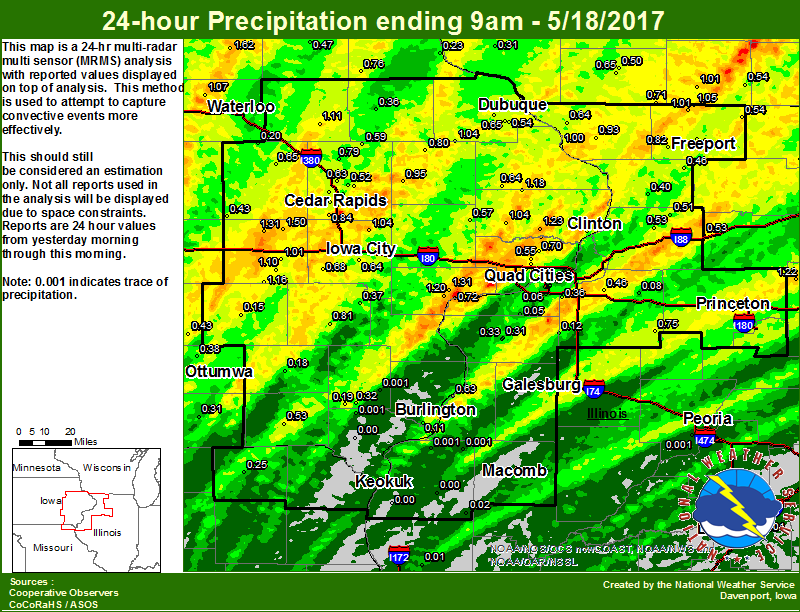 |
24 hour precipitation reports (in Inches),
for eastern Iowa, northwest and west central Illinois,
and northeast Missouri. Reported between Midnight and 9 AM,
Thursday May 18, 2017.

....IOWA....
Tripoli                          1.62
Amana 4.7 W                      1.50
Marengo                          1.31
Muscatine 2N                     1.31
De Witt                          1.23
Cresco                           1.20
Muscatine 1.4 N                  1.20
Delmar 2.3 NW                    1.18
North English                    1.16
Quasqueton 0.4 WSW               1.11
Parnell 0.1 SSW                  1.10
Davenport Arpt                   1.09
Waterloo ASOS                    1.07
De Witt 4S                       1.06
Calamus 2.0 NE                   1.04
Solon 0.3 ESE                    1.04
Cascade                          1.04
Davenport 3.8 NNW                1.01
Williamsburg                     1.01
Bellevue LD12                    1.00
Marshalltown                     0.99
Anamosa 3 SSW                    0.95
Cedar Rapids Arpt                0.84
Washington                       0.81
Monticello                       0.80
Central City 6.7 W               0.79
Strawberry Point                 0.76
Rathbun Reservoir                0.74
Marshalltown ASOS                0.72
Cedar Rapids 2.2 WSW             0.72
Park View 0.2 WSW                0.70
Cedar Rapids 3.4 NW              0.70
Kalona 7.3 NNW                   0.68
Mason City                       0.67
Peosta 2.9 E                     0.65
Vinton                           0.65
Maquoketa 4W                     0.64
Iowa City Arpt                   0.64
Camanche 1.2 W                   0.64
Robins 0.4 SSE                   0.63
Albia                            0.62
Marion 1.2 NE                    0.60
Coggon                           0.59
Lowden                           0.57
Beaconsfield                     0.56
Eldridge 0.7 SSW                 0.55
Dubuque Arpt                     0.54
Dubuque #3                       0.53
Dubuque LD11                     0.53
Keosauqua                        0.53
Cedar Rapids 2.7 NE              0.53
Marion 1.7 NNW                   0.52
Mason City ASOS                  0.52
Fayette                          0.47
Centerville                      0.45
NWS Johnston*                    0.45
Oskaloosa AWOS                   0.43
Oskaloosa                        0.43
Belle Plaine                     0.43
Burlington Arpt                  0.39
Ottumwa ASOS                     0.38
Ainsworth 7.4 N                  0.37
Manchester                       0.36
Grinnell                         0.33
Salem 3.1 ESE                    0.32
Ames US 30                       0.31
Bloomfield                       0.31
Gilman                           0.30
Perry                            0.28
Hampton                          0.28
Toledo                           0.24
Guttenberg Dam 10                0.23
Grinnell AWOS                    0.22
Pella                            0.20
Mount Auburn 2.2 NNW             0.20
Salem 1S                         0.19
Fairfield                        0.18
Boone                            0.16
Sigourney                        0.15
Davenport 0.9 WNW                0.11
Burlington 6.5 SSW               0.11
Davenport 0.9 SSW                0.10
Le Claire LD14                   0.10
Keokuk 0.6 NE                    0.03
Bettendorf 2.2 SE                0.02
New London 1.5 SW                0.00
West Point 7.5 NW                0.00
Pella AWOS                       0.00
Donnellson                       0.00
Keokuk LD19                      0.00
....ILLINOIS....
Mendota                          1.22
Orangeville 2.8 NW               1.05
Winslow 4.3 ESE                  1.01
Elizabeth                        0.93
Princeton 1.5 S                  0.91
Ridott 0.1 NE                    0.89
Rockford ASOS                    0.83
Pearl City 0.4 SW                0.82
Princeton 1.1 SE                 0.80
Princeton                        0.80
Kewanee                          0.75
Ill. City LD16                   0.72
Fulton 0.8 SSW                   0.70
Galena                           0.64
Gladstone LD18                   0.63
Freeport                         0.56
Paw Paw                          0.56
Davis 0.5 N                      0.54
Rock Falls                       0.53
Morrison 3.2 E                   0.53
Romeoville                       0.51
Coleta 1.4 SSW                   0.51
Freeport 2.0 NW                  0.49
Shannon 0.2 S                    0.46
Geneseo 2.0 NW                   0.46
Freeport 1.7 ESE                 0.40
Chadwick 2.7 WSW                 0.40
Roscoe 2SE                       0.38
Coal Valley 1.9 SE               0.36
Aledo                            0.33
Aledo 0.4 NE                     0.31
Galesburg Arpt                   0.27
Joliet                           0.19
Rochelle                         0.14
New Windsor 2.0 N                0.12
Moline 0.7 NNE                   0.09
Mundelein                        0.08
Atkinson 2.6 NNE                 0.08
Moline 0.9 N                     0.06
Steward                          0.06
Moline 1.0 WNW                   0.06
Milan 8.8 SSW                    0.05
Quad City Arpt                   0.04
Augusta                          0.02
Quincy ASOS                      0.01
Ottawa                           0.00
La Harpe                         0.00
Dallas City 3.0 SSE              0.00
Bloomington Airport              0.00
Peoria ASOS                      0.00
Lincoln NWS                      0.00
Decatur Airport                  0.00
Bentley                          0.00
Rochelle AWOS                    0.00
Jacksonville AWOS                0.00
Colchester 3.5 NE                0.00
Macomb                           0.00
Warsaw 5.8 SE                    0.00
....MISSOURI....
Memphis                          0.25
Chillicothe                      0.06
Kirksville ASOS                  0.01
Columbia                         0.00
....WISCONSIN....
Whitewater                       1.02
Monroe                           1.01
Sullivan-NWS                     0.96
La Crosse WFO                    0.94
Viroqua                          0.94
South Wayne-4 SW                 0.71
Darlington                       0.65
Beloit-College                   0.60
Allenton-WWTP                    0.56
Brodhead                         0.54
Watertown-AWOS                   0.51
Steuben 4SE                      0.50
Darlington-2 NE                  0.50
Madison-ASOS                     0.45
Lancaster 4WSW                   0.31
Prairie du Chien AWOS            0.19
....MINNESOTA....
Grand Meadow                     1.87
Theilman 1SSW                    1.03
Preston                          0.75
Byron 4N                         0.75
|
Environment
 |
 |
 |
 |
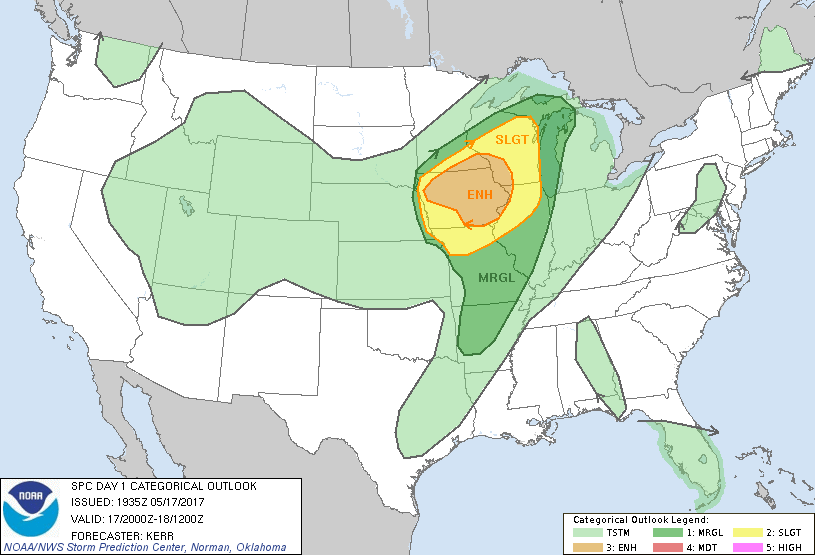
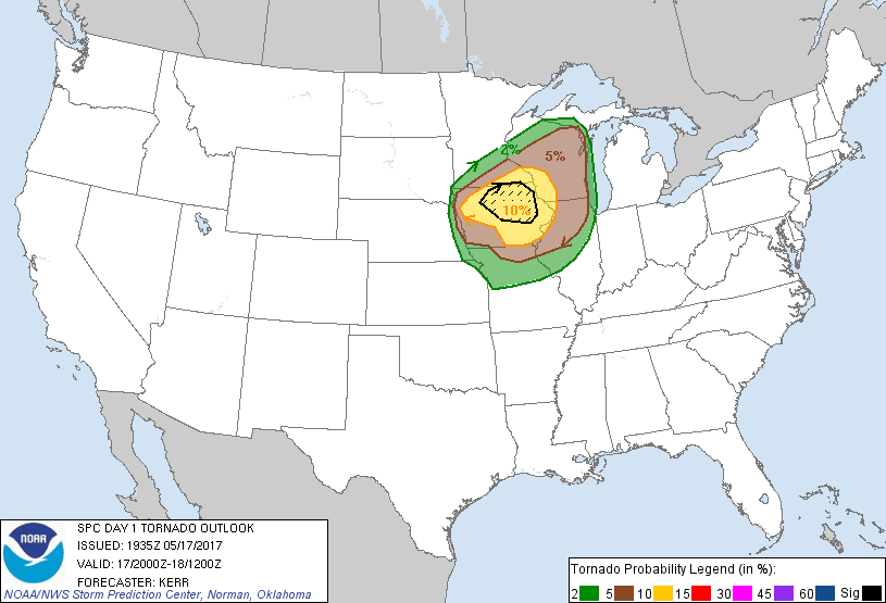
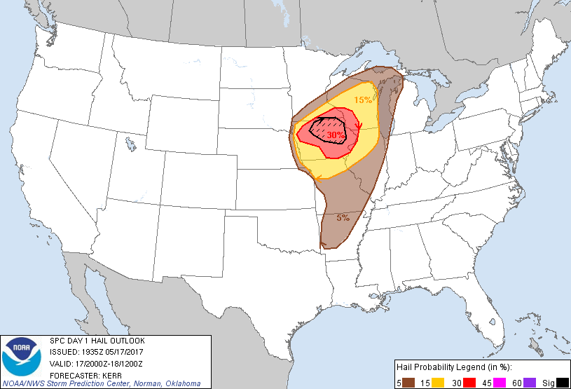
| Figure 1: SPC Categorical Outlook | Figure 2: SPC Tornado Outlook | Figure 3: SPC Hail Outlook | Figure 4: SPC Wind Outlook |
 |
Media use of NWS Web News Stories is encouraged! Please acknowledge the NWS as the source of any news information accessed from this site. |
|