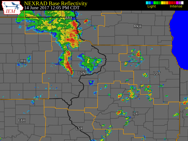
Overview
A warm and humid air mass was in place across eastern Iowa, northwest Illinois, and far northeast Missouri. Several rounds of thunderstorms developed through the day and moved across the area. Some of these thunderstorms became severe in the early morning and again in the afternoon and early evening. These thunderstorms produced large hail, damaging winds, along with heavy rain.
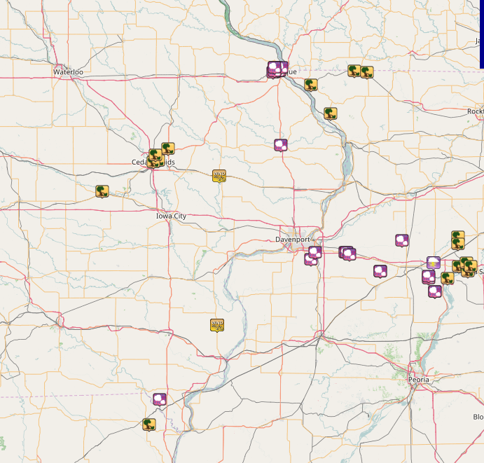
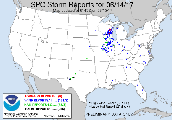
Storm Reports
| Interactive Storm Report Map | SPC Storm Reports |
 |
 |
***Round 1***
PRELIMINARY LOCAL STORM REPORT...SUMMARY
NATIONAL WEATHER SERVICE QUAD CITIES IA IL
823 AM CDT WED JUN 14 2017

..TIME...   ...EVENT...      ...CITY LOCATION...     ...LAT.LON...
..DATE...   ....MAG....      ..COUNTY LOCATION..ST.. ...SOURCE....
            ..REMARKS..

0620 AM     TSTM WND GST     SE STANWOOD             41.89N 91.15W
06/14/2017  E50.00 MPH       CEDAR              IA   TRAINED SPOTTER

            BRIEF TOUCHDOWN OF GUSTNADO IN A FIELD ON SOUTH SIDE OF
            HIGHWAY 30 NEAR JACKSON AVE JUST WEST OF STANWOOD. SOME
            DIRT DEBRIS SEEN NEAR THE BASE. RELAYED BY CEDAR COUNTY
            SHERIFF OFFICE.

0600 AM     TSTM WND DMG     2 NNE CEDAR RAPIDS      42.01N 91.65W
06/14/2017                   LINN               IA   TRAINED SPOTTER

            8 TO 10 INCH DIAMETER TREE SNAPPED FROM BASE. TIME
            ESTIMATED.

0555 AM     TSTM WND DMG     CEDAR RAPIDS            41.97N 91.67W
06/14/2017                   LINN               IA   PUBLIC

            MANY TREES HALF SNAPPED OFF BETWEEN 19TH ST.AND BLAIRS
            FERRY RD. TIME ESTIMATED BASED ON RADAR.

0550 AM     TSTM WND DMG     2 ENE MARION            42.05N 91.55W
06/14/2017                   LINN               IA   TRAINED SPOTTER

            SEMI BLOWN OVER ON HIGHWAY 13 FROM THUNDERSTORM OUTFLOW
            WINDS. TIME ESTIMATED FROM RADAR.

0540 AM     TSTM WND DMG     2 E CEDAR RAPIDS        41.98N 91.63W
06/14/2017                   LINN               IA   TRAINED SPOTTER

            SMALL TREE LIMBS DOWN.
***Round 2***

PRELIMINARY LOCAL STORM REPORT...SUMMARY
NATIONAL WEATHER SERVICE QUAD CITIES IA IL
658 PM CDT WED JUN 14 2017

..TIME...   ...EVENT...      ...CITY LOCATION...     ...LAT.LON...
..DATE...   ....MAG....      ..COUNTY LOCATION..ST.. ...SOURCE....
            ..REMARKS..

0200 PM     TSTM WND GST     NW MEDIAPOLIS           41.01N 91.17W
06/14/2017  E60.00 MPH       DES MOINES         IA   TRAINED SPOTTER

            ESTIMATED WINDS

0208 PM     HAIL             N SUNNY HILL            41.40N 90.43W
06/14/2017  E1.00 INCH       ROCK ISLAND        IL   PUBLIC

            NICKEL TO QUARTER HAIL IN THE SUNNY HILL ESTATES. REPORT
            VIA SOCIAL MEDIA AND THE TIME OF THE EVENT WAS ESTIMATED
            BY RADAR.

0218 PM     HAIL             5 SSE EAST MOLINE       41.44N 90.40W
06/14/2017  M0.75 INCH       HENRY              IL   TRAINED SPOTTER

0245 PM     HAIL             1 SSW GENESEO           41.44N 90.16W
06/14/2017  E0.75 INCH       HENRY              IL   TRAINED SPOTTER

0250 PM     HAIL             1 SSE GENESEO           41.44N 90.15W
06/14/2017  E0.88 INCH       HENRY              IL   TRAINED SPOTTER

0251 PM     HAIL             2 SE GENESEO            41.43N 90.13W
06/14/2017  E1.00 INCH       HENRY              IL   PUBLIC

0324 PM     HAIL             JOHNSON SAUK TRAIL STAT 41.33N 89.89W
06/14/2017  M0.88 INCH       HENRY              IL   LAW ENFORCEMENT

            RELAYED BY EMERGENCY MANAGER

0348 PM     HAIL             1 SW LAKE THUNDERBIRD   41.21N 89.46W
06/14/2017  E0.75 INCH       PUTNAM             IL   TRAINED SPOTTER

            ALSO REPORTED WIND GUST OF 30 MPH.

0357 PM     TSTM WND DMG     PRINCETON               41.38N 89.47W
06/14/2017                   BUREAU             IL   EMERGENCY MNGR

            TIME ESTIMATED FROM RADAR. TREES AND POWER LINES DOWN.

0359 PM     TSTM WND DMG     BUREAU                  41.29N 89.36W
06/14/2017                   BUREAU             IL   EMERGENCY MNGR

            TIME ESTIMATED FROM RADAR. TREES AND POWER LINES DOWN.

0400 PM     LIGHTNING        PRINCETON               41.38N 89.47W
06/14/2017                   BUREAU             IL   TRAINED SPOTTER

            TIME APPROXIMATED. TREE STRUCK BY LIGHTNING.

0400 PM     HAIL             TISKILWA                41.29N 89.51W
06/14/2017  M1.25 INCH       BUREAU             IL   PUBLIC

            CORRECTED REPORT FOR LOCATION. VIA SOCIAL MEDIA PICTURE.
            TIME APPROXIMATED.

0400 PM     TSTM WND DMG     SEATONVILLE             41.36N 89.27W
06/14/2017                   BUREAU             IL   EMERGENCY MNGR

            TIME ESTIMATED FROM RADAR. TREES AND POWER LINE DOWN.

0404 PM     HAIL             WNW TISKILWA            41.30N 89.51W
06/14/2017  E0.25 INCH       BUREAU             IL   TRAINED SPOTTER

            VIA SOCIAL MEDIA.

0406 PM     TSTM WND DMG     LA MOILLE               41.53N 89.28W
06/14/2017                   BUREAU             IL   EMERGENCY MNGR

            TIME ESTIMATED FROM RADAR. TREES AND POWER LINES DOWN.

0407 PM     TSTM WND DMG     3 S LA MOILLE           41.49N 89.28W
06/14/2017                   BUREAU             IL   TRAINED SPOTTER

            SPOTTER REPORTED LARGE TREE DOWN NEAR THE INTERSECTON OF
            US 34 AND IL 89 SOUTH OF LA MOILLE. REPORT WAS RELAYED BY
            NWS LOT.

0408 PM     TSTM WND DMG     SPRING VALLEY           41.33N 89.20W
06/14/2017                   BUREAU             IL   EMERGENCY MNGR

            REPORTS OF MUTLIPLE TREES DOWN ALONG WITH POWER LINES.
            POWER IS OUT IN TOWN. TIME OF THE EVENT WAS ESTIMATED
            USING RADAR.

0410 PM     TSTM WND DMG     LADD                    41.38N 89.21W
06/14/2017                   BUREAU             IL   EMERGENCY MNGR

            MULTIPLE TRES DOWN IN LADD. TIME OF THE EVENT WAS
            ESTIMATED USING RADAR.

0414 PM     TSTM WND DMG     DALZELL                 41.36N 89.18W
06/14/2017                   BUREAU             IL   EMERGENCY MNGR

            TIME ESTIMATED FROM RADAR. TREES AND POWER LINES DOWN.

0430 PM     TSTM WND DMG     1 E KAHOKA              40.42N 91.70W
06/14/2017                   CLARK              MO   LAW ENFORCEMENT

            TREES AND POWER LINES DOWN.

0446 PM     HAIL             4 NW ARGYLE             40.57N 91.62W
06/14/2017  M1.00 INCH       LEE                IA   TRAINED SPOTTER

0609 PM     HAIL             1 WNW DUBUQUE           42.51N 90.71W
06/14/2017  M1.00 INCH       DUBUQUE            IA   TRAINED SPOTTER

            HEAVY RAIN AND QUARTER HAIL.

0611 PM     HAIL             SE DUBUQUE              42.50N 90.68W
06/14/2017  E1.00 INCH       DUBUQUE            IA   TRAINED SPOTTER

            LOTS OF SMALL HAIL, AND A FEW QUARTERS

0612 PM     HAIL             DUBUQUE                 42.50N 90.69W
06/14/2017  M1.00 INCH       DUBUQUE            IA   911 CALL CENTER

            DIME TO QUARTER SIZE HAIL.

0612 PM     HAIL             2 WNW DUBUQUE           42.52N 90.72W
06/14/2017  M1.75 INCH       DUBUQUE            IA   TRAINED SPOTTER

0612 PM     HAIL             1 NW DUBUQUE            42.52N 90.70W
06/14/2017  E1.00 INCH       DUBUQUE            IA   TRAINED SPOTTER

0612 PM     HAIL             2 WSW DUBUQUE           42.49N 90.73W
06/14/2017  M1.00 INCH       DUBUQUE            IA   TRAINED SPOTTER

0613 PM     HAIL             2 NE DUBUQUE            42.52N 90.66W
06/14/2017  M0.75 INCH       DUBUQUE            IA   TRAINED SPOTTER

0615 PM     HAIL             2 WNW DUBUQUE           42.52N 90.72W
06/14/2017  M1.00 INCH       DUBUQUE            IA   TRAINED SPOTTER

            1 TO 1.125 INCH DIAMETER HAIL.

0615 PM     HAIL             1 W DUBUQUE             42.50N 90.72W
06/14/2017  M0.75 INCH       DUBUQUE            IA   TRAINED SPOTTER

            DIME TO PENNY SIZE HAIL. HAIL LAST FOR 5
|
|
 |
Media use of NWS Web News Stories is encouraged! Please acknowledge the NWS as the source of any news information accessed from this site. |