
Heavy lake effect snow and gusty winds, including some local blizzard conditions, will continue into Thanksgiving Day across the Great Lakes then lingering through Friday night for Lakes Erie and Ontario. Confidence is increasing for another winter storm to develop over the northern and central Rockies Friday and track across the central Plains through the Midwest and Great Lakes this weekend. Read More >
Overview
A strong cold front moved through Utah and Colorado on Monday, bringing widespread snowfall and blizzard-like conditions to eastern Utah and western Colorado.
Wind significantly picked up across Utah and Colorado Saturday night and Sunday, with gusts of 50 to 70 mph at mountain passes. The wind became even stronger on Monday as the cold front passed through, with gusts in valleys gusting 40 to 60 mph and a notable recording of 115 mph at nearly 13,000 ft in the San Juans. Snow initially began in southwesterly flow across the high terrain of southeastern Utah and southwestern Colorado late Sunday night before the front moved through on Monday. Highway 550 was closed due to hazardous conditions beginning Monday, February 19th at 5:20pm from mile marker 49 to 92 including Red Mountain, Molas, and Coal Bank Passes. Part of this corridor of Highway 550 reopened on Tuesday, February 20th around 11am, with the rest of the corridor reopening just before 1pm on February 20th.
Photos & Video:
Header
 |
 |
 |
 |
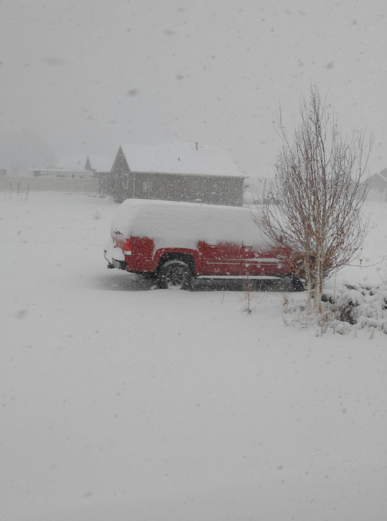
| Naples, Utah on 2-19-18 (Photo courtesy Laretta Johnson) |
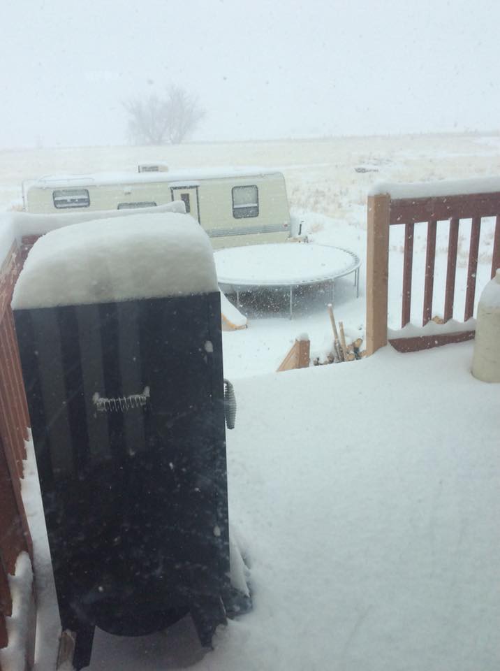
Maeser, Utah on 2-19-18 (Photo courtesy Michelle Grady) |
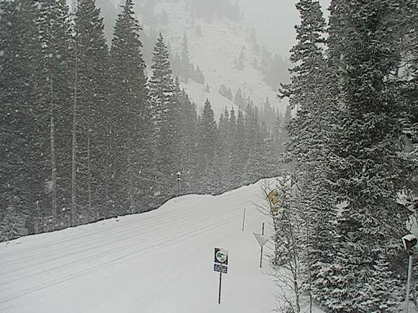
Red Mountain Pass 2-19-18 before Hwy 550 closed due to adverse conditions (Photo courtesy CDOT) |
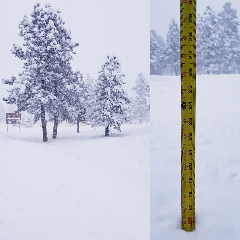
Flaming Gorge, Utah on 2-19-18 (Photo courtesy Bill Coulter) |
Storm Reports
...Snowfall and Wind Reports in the Previous 24 Hours...

Snowfall Reports...

Location                     Amount    Time/Date       Lat/Lon/Elev (ft.)

...Colorado...

...Archuleta County...
Chimney Rock 3N              3.0 in    0700 AM 02/20   37.25N/107.18W/7148
Pagosa Spgs 6W               3.0 in    0810 AM 02/20   37.27N/107.10W/7487
Pagosa Springs 15.0SSE       2.8 in    0700 AM 02/20   37.07N/106.91W/7408
Pagosa Springs 2.5W          2.5 in    0700 AM 02/20   37.27N/107.06W/7566
Pagosa Spgs 15SE             2.0 in    1007 PM 02/19   37.07N/106.91W/7410

...Delta County...
Cedaredge 10.5NNW            7.5 in    0800 AM 02/20   39.04N/108.00W/10399
Paonia 2.1SSE                3.0 in    0700 AM 02/20   38.84N/107.57W/6100
Hotchkiss 5.4NE              1.2 in    0700 AM 02/20   38.86N/107.65W/5937
Hotchkiss 7.1WNW             1.1 in    0700 AM 02/20   38.86N/107.83W/6600
Hotchkiss 5WNW               1.0 in    0706 AM 02/20   38.82N/107.81W/5763

...Eagle County...
Avon 2NNW                    5.0 in    0715 AM 02/20   39.66N/106.54W/8242
Avon 2N                      5.0 in    0600 AM 02/20   39.67N/106.55W/8200
Carbondale 5.7E              4.3 in    0650 AM 02/20   39.40N/107.11W/6427
Edwards 1WNW                 3.9 in    0715 AM 02/20   39.65N/106.62W/7170
Vail 0.9WNW                  3.6 in    0700 AM 02/20   39.65N/106.40W/8172
Vail 2.6E                    3.5 in    0700 AM 02/20   39.65N/106.33W/8389
Avon 1.1SE                   3.4 in    1000 AM 02/20   39.64N/106.52W/7603
Gypsum 3SE                   2.6 in    0547 PM 02/19   39.61N/106.91W/6919
Wolcott 2.3N                 1.9 in    0700 AM 02/20   39.73N/106.68W/7224
Wolcott 2N                   1.9 in    0700 AM 02/20   39.73N/106.68W/7215
Gypsum 1.9SSW                1.0 in    0700 AM 02/20   39.62N/106.96W/6531

...Garfield County...
New Castle                   3.0 in    0921 AM 02/20   39.57N/107.53W/5592
Glenwood Springs 1.7NW       1.9 in    0700 AM 02/20   39.57N/107.35W/6050
Rifle 3ENE                   1.5 in    0700 AM 02/20   39.55N/107.73W/5436
Rifle 3.2ENE                 1.5 in    0700 AM 02/20   39.56N/107.73W/5472
Glenwood Springs 5.3SSE      1.4 in    0700 AM 02/20   39.48N/107.29W/5942
Carbondale 4.6NNE            1.1 in    0700 AM 02/20   39.46N/107.18W/6521

...Gunnison County...
Crested Butte 6W             9.0 in    0700 AM 02/20   38.88N/107.10W/10340
Pitkin 1.1SW                 6.0 in    0700 AM 02/20   38.60N/106.53W/9139
Gothic                       5.0 in    0700 AM 02/20   38.97N/106.98W/9469
Cimarron 11.2S               5.0 in    0700 AM 02/20   38.29N/107.55W/8356
Crested Butte 6.2N           5.0 in    0700 AM 02/20   38.96N/106.99W/9606
Parlin 2.7ESE                4.0 in    0700 AM 02/20   38.48N/106.67W/8004
Powderhorn 4.4NNE            3.8 in    0800 AM 02/20   38.34N/107.09W/9065
Irwin Ski Lodge              3.0 in    0400 PM 02/19   38.89N/107.11W/10402
Gunnison                     3.0 in    0551 PM 02/19   38.54N/106.92W/7685
Doyleville 2.1W              1.5 in    0745 AM 02/20   38.42N/106.62W/8134
Gunnison 3WSW                1.5 in    0700 AM 02/20   38.52N/106.98W/7602

...Hinsdale County...
Lake City 1NNE               3.0 in    0700 AM 02/20   38.05N/107.30W/8714

...La Plata County...
Purgatory Ski Resort         10.0 in   0700 AM 02/20   37.62N/107.84W/10253
Bayfield 7N                  6.0 in    0925 AM 02/20   37.32N/107.60W/7404
Bayfield 7N                  5.3 in    0700 AM 02/20   37.31N/107.60W/7460
Bayfield 7.0N                5.0 in    0700 AM 02/20   37.34N/107.61W/8200
4 ENE Rockwood               4.0 in    0700 AM 02/20   37.53N/107.74W/MSG
Vallecito Res. 3N            3.0 in    0830 AM 02/20   37.47N/107.55W/7851
Vallecito Res. 3N            2.5 in    0652 PM 02/19   37.47N/107.55W/7851
Durango 4SSE                 2.0 in    0700 AM 02/20   37.23N/107.87W/6431
Bayfield 8N                  2.0 in    0730 AM 02/20   37.33N/107.61W/7592
Hesperus 13.3SSW             1.5 in    0715 AM 02/20   37.11N/108.14W/6686
Redmesa 4.2NW                1.5 in    0800 AM 02/20   37.14N/108.23W/6771
Ignacio 8E                   1.0 in    0700 AM 02/20   37.09N/107.53W/6562
Durango 0.8SSW               1.0 in    0700 AM 02/20   37.27N/107.87W/6624

...Mesa County...
Plateau City 3E              7.0 in    0700 AM 02/20   39.18N/107.92W/7044
Mesa 6S                      5.5 in    0600 AM 02/20   39.09N/108.12W/7720
Collbran                     5.3 in    0800 AM 02/20   39.24N/107.96W/5987
Glade Park 17W               3.0 in    0852 AM 02/20   38.95N/109.05W/6323
Glade Park 17W               3.0 in    0800 AM 02/20   38.95N/109.05W/6385
Colorado Nat`l Monument      2.2 in    0830 AM 02/20   39.10N/108.73W/5780
Redlands 2WNW                2.0 in    0700 AM 02/20   39.10N/108.70W/4780
De Beque 7.1SSE              2.0 in    0700 AM 02/20   39.24N/108.15W/5606
Collbran                     1.4 in    0426 PM 02/19   39.24N/107.96W/6037
3 NNE Grand Junction         1.0 in    0537 AM 02/20   39.13N/108.52W/MSG
Grand Jct. Redlands 2SW      0.9 in    0834 AM 02/20   39.04N/108.63W/4894

...Moffat County...
2 E Craig                    7.0 in    0500 PM 02/19   40.52N/107.52W/MSG
Craig 5NW                    5.0 in    0800 AM 02/20   40.58N/107.60W/6780
Massadona                    5.0 in    0900 AM 02/20   40.25N/108.64W/5798
Craig 4SW                    5.0 in    0700 AM 02/20   40.45N/107.61W/6440
Massadona                    5.0 in    0900 AM 02/20   40.25N/108.64W/5810
Dinosaur 0.3SW               2.1 in    0700 AM 02/20   40.24N/109.01W/5872

...Montezuma County...
Mancos 7W                    2.7 in    0800 AM 02/20   37.35N/108.41W/7050
Cortez 11NW                  2.0 in    0700 AM 02/20   37.45N/108.68W/6598
Dolores 4.0SSW               2.0 in    0641 AM 02/20   37.42N/108.53W/6679
Mancos 3WNW                  2.0 in    0700 AM 02/20   37.38N/108.35W/7050
Dolores 4.8ENE               1.5 in    0700 AM 02/20   37.49N/108.42W/7132
Cortez 2.0NW                 1.5 in    0800 AM 02/20   37.37N/108.61W/6168
Cortez                       1.3 in    0608 PM 02/19   37.34N/108.59W/6167
Cortez 7.8WSW                1.0 in    0900 AM 02/20   37.33N/108.72W/5720

...Montrose County...
Montrose 15W                 4.8 in    1123 AM 02/20   38.46N/108.16W/7603
Black Canyon of the Gunnison 3.0 in    0830 AM 02/20   38.55N/107.69W/8150
5 NW Montrose                2.5 in    1123 AM 02/20   38.54N/107.93W/MSG
Olathe 3.2NNE                2.1 in    0600 AM 02/20   38.65N/107.97W/5280
Montrose 8.1WNW              2.0 in    0700 AM 02/20   38.52N/108.01W/5770
Montrose 4.0NW               2.0 in    0730 AM 02/20   38.53N/107.92W/5729

...Ouray County...
Silverton 6.9NNW             6.3 in    1105 AM 02/20   37.91N/107.71W/11067
5 WSW Colona                 2.8 in    1124 PM 02/19   38.25N/107.83W/MSG
Ouray 0.23NNW                2.5 in    0723 AM 02/20   38.03N/107.67W/7728
Ouray                        2.5 in    0723 AM 02/20   38.03N/107.67W/7718
Colona 5SW                   2.2 in    0800 AM 02/20   38.22N/107.81W/7828
Colona 3SW                   1.0 in    0830 AM 02/20   38.24N/107.79W/7444
Ridgway                      1.0 in    0830 AM 02/20   38.15N/107.76W/6995

...Pitkin County...
Snowmass Ski Resort          13.9 in   0600 AM 02/20   39.18N/106.95W/10493

...Rio Blanco County...
Meeker                       3.8 in    0800 AM 02/20   40.04N/107.91W/6229
Rangely 1E                   2.0 in    0700 AM 02/20   40.09N/108.77W/5290

...Routt County...
Hayden                       6.0 in    0600 PM 02/19   40.49N/107.25W/6440
5 ENE Phippsburg             6.0 in    0600 AM 02/20   40.25N/106.84W/MSG
Oak Creek 5WNW               6.0 in    0955 AM 02/20   40.30N/107.04W/7808
Steamboat Springs 1.9E       4.9 in    0600 AM 02/20   40.47N/106.79W/7200
Steamboat Springs 0.6NNW     4.7 in    0700 AM 02/20   40.49N/106.82W/6812
Steamboat Springs 1.5WNW     4.6 in    0700 AM 02/20   40.49N/106.85W/6778
Steamboat Springs 3.5S       4.5 in    0900 PM 02/19   40.49N/106.84W/6704
Steamboat Springs 1.2SE      4.5 in    0535 AM 02/20   40.47N/106.80W/7075
Steamboat Ski Resort         4.0 in    0456 PM 02/19   40.45N/106.77W/8961
Yampa 5.1S                   4.0 in    0700 AM 02/20   40.08N/106.89W/8496
Steamboat Springs 0.1NNE     3.8 in    0700 AM 02/20   40.49N/106.83W/6743
Steamboat Springs 0.7ESE     3.4 in    0700 AM 02/20   40.48N/106.81W/7049
Oak Creek 5WNW               2.5 in    0420 PM 02/19   40.30N/107.04W/7808
Oak Creek 0.3WSW             2.1 in    0700 AM 02/20   40.27N/106.96W/7441

...San Juan County...
Silverton                    8.4 in    0715 AM 02/20   37.81N/107.67W/9289

...San Miguel County...
Placerville 9NE              10.0 in   0941 AM 02/20   38.06N/107.91W/9470
Telluride Ski Resort         9.0 in    0600 AM 02/20   37.91N/107.83W/11229
Telluride                    3.0 in    0600 PM 02/19   37.94N/107.81W/8785

...Utah...

...Daggett County...
1 SSW Manila                 12.2 in   1245 PM 02/19   40.98N/109.73W/MSG

...Uintah County...
Vernal 1SW                   8.2 in    1220 PM 02/19   40.43N/109.55W/5426
Vernal                       5.1 in    0700 AM 02/20   40.44N/109.54W/5345
Vernal 0.8S                  5.1 in    0630 AM 02/20   40.44N/109.54W/5351
Naples                       4.0 in    0700 AM 02/20   40.44N/109.49W/5200
Jensen 0.4 WSW               2.4 in    0700 AM 02/20   40.37N/109.35W/4768
Fort Duchesne                1.5 in    0715 AM 02/20   40.28N/109.86W/5050

Hail Reports...

Location                     Size      Time/Date       Lat/Lon/Elev (ft.)

...Colorado...

...Delta County...
Paonia                       0.25 in   0445 PM 02/19   38.87N/107.59W/MSG

Wind Reports...

Location                     Speed     Time/Date       Lat/Lon/Elev (ft.)

...Colorado...

...Archuleta County...
Stevens Field Arpt           53 MPH    0215 PM 02/19   37.29N/107.06W/7664
Chromo 6N                    46 MPH    0346 PM 02/19   37.12N/106.82W/9212
Sandoval Mesa, Arboles 7NE   45 MPH    0312 PM 02/19   37.10N/107.30W/8491
Devil Mtn, Chimny Rk 7WNW    43 MPH    0358 PM 02/19   37.23N/107.31W/7460
Pagosa Springs               40 MPH    0304 PM 02/19   37.27N/107.03W/7199

...Delta County...
Jay, Hotchkiss 3NNW          57 MPH    0152 PM 02/19   38.85N/107.74W/6200
Blake Field Airport, Delta   53 MPH    0135 PM 02/19   38.79N/108.06W/5193
Whitewater 11SE              47 MPH    0106 PM 02/19   38.84N/108.30W/5285
Whitewater 11SSE             40 MPH    1259 PM 02/19   38.82N/108.34W/4698

...Dolores County...
Salter, Dolores 12NNW        50 MPH    1224 PM 02/19   37.65N/108.54W/8201
Dove Creek 7WNW              46 MPH    1244 PM 02/19   37.81N/109.02W/6673

...Eagle County...
Dowd                         42 MPH    0602 PM 02/19   39.61N/106.45W/7747
Gypsum 3NNW                  41 MPH    1213 PM 02/19   39.69N/106.97W/7412

...Garfield County...
Sunlight Mountain            56 MPH    0154 PM 02/19   39.43N/107.38W/10603
Deep Crk, NewCastle 14NNW    56 MPH    0155 PM 02/19   39.77N/107.65W/9404
Shoshone 2NE                 53 MPH    0102 PM 02/19   39.60N/107.15W/6338
Strm King Mt, Glnwood 4NW    51 MPH    1258 PM 02/19   39.59N/107.40W/8793
Demaree, Mack 16N            40 MPH    0249 PM 02/19   39.46N/108.88W/7448

...Gunnison County...
Mount Crested Butte          48 MPH    0745 PM 02/19   38.91N/106.96W/9600
Huntsmn Mesa, Powdrhrn 3N    42 MPH    0148 PM 02/19   38.33N/107.09W/9400

...La Plata County...
Durango La Plata Cnty Airpor 56 MPH    0253 PM 02/19   37.14N/107.76W/6685
Mesa Mtn, Ignacio 5SW        54 MPH    0409 PM 02/19   37.06N/107.71W/7380
Log Chute, Trimble 5SW       50 MPH    0158 PM 02/19   37.35N/107.91W/8254
Bayfield 3ESE                47 MPH    0335 PM 02/19   37.21N/107.54W/6978
Durango                      42 MPH    1257 PM 02/19   37.28N/107.88W/6539

...Mesa County...
Pine Ridge, Cameo 6NW        52 MPH    0434 PM 02/19   39.24N/108.38W/6710
Grand Mesa at Skyway         44 MPH    0100 PM 02/19   39.06N/108.06W/10628
Skyway 3E                    44 MPH    1200 PM 02/19   39.05N/108.06W/10627
Cameo 6NNE                   42 MPH    1224 PM 02/19   39.24N/108.27W/4792

...Montezuma County...
Mancos 4E                    57 MPH    0814 PM 02/19   37.34N/108.21W/7910
Cortez Municipal Airport     56 MPH    0128 PM 02/19   37.30N/108.63W/5918
Mockingbird, Ylw Jacket 9SW  49 MPH    1244 PM 02/19   37.47N/108.88W/6420
Towaoc 11W                   46 MPH    0155 PM 02/19   37.19N/108.93W/5319
Towaoc 3NE                   44 MPH    0300 PM 02/19   37.25N/108.69W/5975

...Montrose County...
Montrose Rgnl Airport        66 MPH    1222 PM 02/19   38.51N/107.89W/5759
Nucla, Naturita 1NNE         52 MPH    1258 PM 02/19   38.23N/108.56W/5860
Cottonwood Basin             48 MPH    0148 PM 02/19   38.57N/108.28W/7220
Montrose 5WNW                43 MPH    1205 PM 02/19   38.51N/107.96W/5764
Olathe 1W                    41 MPH    0209 PM 02/19   38.60N/108.00W/5361

...Ouray County...
Mt Abrahms                   79 MPH    0200 PM 02/19   37.96N/107.65W/11841
Senator Beck                 75 MPH    1100 PM 02/19   37.91N/107.73W/12186

...Rio Blanco County...
Rangely 2E                   45 MPH    0535 PM 02/19   40.09N/108.77W/5247
Dragon Road                  40 MPH    0618 PM 02/19   39.92N/108.89W/6290

...Routt County...
4 WSW Rabbit Ears Pass       45 MPH    0148 PM 02/19   40.35N/106.70W/10577
Steamboat Springs 1S         40 MPH    0205 PM 02/19   40.46N/106.82W/6751

...San Juan County...
Eagle Mountain               115 MPH   0200 PM 02/19   37.88N/107.74W/12851
Kendall Mountain             95 MPH    0300 PM 02/19   37.79N/107.64W/13064
Molas Pass                   49 MPH    0500 PM 02/19   37.75N/107.69W/10801
Silverton                    39 MPH    1017 PM 02/19   37.81N/107.67W/9318

...San Miguel County...
Telluride 2SSW               89 MPH    0400 PM 02/19   37.90N/107.82W/12550
Telluride Regional Arpt      48 MPH    1235 PM 02/19   37.95N/107.91W/9070

...Utah...

...Grand County...
Canyonlands Field Airport    62 MPH    1201 PM 02/19   38.76N/109.75W/4553

...San Juan County...
Big Indian Valley            55 MPH    1220 PM 02/19   38.22N/109.28W/6960
Blanding 18W                 48 MPH    0240 PM 02/19   37.56N/109.82W/7110
Blanding                     44 MPH    1235 PM 02/19   37.58N/109.48W/5868
Monticello 7WSW, nr Abajo Pk 44 MPH    1200 PM 02/19   37.84N/109.46W/11330
La Sal 3WSW                  41 MPH    1200 PM 02/19   38.31N/109.24W/7049
Monticello 5SSE              40 MPH    1207 PM 02/19   37.80N/109.30W/5435
Alkali Mesa                  39 MPH    1200 PM 02/19   37.67N/109.36W/6451

...Uintah County...
Artesia 23SW                 53 MPH    0520 PM 02/19   39.98N/109.35W/5308
Winter Ridge, Mack 41WNW     44 MPH    1227 PM 02/19   39.50N/109.56W/7378
McCook Ridge, Mack 35NW      39 MPH    1227 PM 02/19   39.63N/109.27W/6722

Observations are collected from a variety of sources with varying
equipment and exposures. We thank all volunteer weather observers
for their dedication. Not all data listed are considered official.
 |
Media use of NWS Web News Stories is encouraged! Please acknowledge the NWS as the source of any news information accessed from this site. |
|

