
A winter storm will impact the central Appalachians to the Northeast through the night. Accumulating snow is expected for interior New England and the northern Mid-Atlantic. Scattered showers and occasional thunderstorms will persist across Florida and the Southeast coast. Locally heavy mountain snow is expected in the Great Basin and Rockies over the next couple of days. Read More >
Grand Junction, CO
Weather Forecast Office
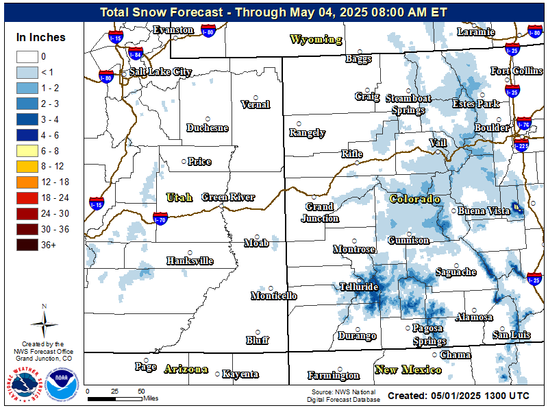
A wet and warm storm system will continue to bring widespread rain to lower elevations and snow to the higher mountains of eastern Utah and western Colorado today. The only significant snow accumulation will be above 9,500 feet where Winter Weather Advisories remain in effect until 6 PM MDT tonight for the mountains of western Colorado. Conditions clear out tonight as a weak ridge of high pressure builds over the region.
Be sure to stay up to date with the latest forecast by visiting our point & click weather forecast at weather.gov/gjt
Link to Latest Weather Map

Hazards
Detailed Hazards Viewer
National Briefing
Outlooks
Transportation Decision Support
Winter Storm Severity Index
Forecasts
Aviation Weather
Fire Weather
Forecast Discussion
Forecast Points
Local Area
Severe Weather
Soaring Forecast
Winter Weather
Hydrology
Recreational River Report
River Forecast
Weather Safety
Preparedness
NOAA Weather Radio
StormReady
SkyWarn
US Dept of Commerce
National Oceanic and Atmospheric Administration
National Weather Service
Grand Junction, CO
2844 Aviators Way
Grand Junction, CO 81506-8644
970-243-7007
Comments? Questions? Please Contact Us.

