A Snow Surprise
From the Huntsville Times on December 31, 2003.
New Year's Eve snow shocked city back in '63
By John Anderson, Times Staff Writer
Forty years ago this morning North Alabama partygoers-to-be woke up to a typical National Weather Service forecast for early winter here: cold rain throughout the day, possibly mixed with sleet.
It was not a forecast for the ages.
About noon the rain turned into snow as cold air slid farther south than expected. By the stroke of midnight 12 hours later, 15.3 inches of snow smothered the city. That's the most snow ever recorded here by the weather service, which opened its Huntsville office in 1958.
But even old-timers said then the New Year Eve's snowstorm was the worst since 1899.
It snowed so much that Huntsville had the dubious distinction of recording the most snow of any weather service station in the continental United States that last day of 1963.
"Huntsville Crowned Nation's Top Snow-Getter for New Year," The Times headline proclaimed New Year's Day, 1964. Another two inches or so fell after midnight, bringing the total snowfall in this part of the Heart of Dixie to over 1.5 feet.
The result? Bedlam.
In a town that goes nuts when a dusting falls, a Times reporter described Huntsville as a "paralyzed, helpless city."
"Traffic jams involving thousands of cars backed up on Memorial Parkway and other major and side streets as the wintry blast reached its peak last night. Hundreds of vehicles were abandoned and still stranded today," the reporter wrote.
Another Times story reported that the Civil Defense revived a man found unconscious as his car's motor continued running after he plowed into a snow bank on U.S. 431 near Big Cove School late New Year's Eve, and police rescued a family of seven - including five children - stranded in their car on Leeman Ferry Road.
The snow was so heavy it squashed shrubs and tore awnings off store fronts.
So impressive was the storm, John Gordon, chief weather service meteorologist in Huntsville, is gathering as much data about it as he can to help train his staff on the rare, but always possible, mega-winter storms in North Alabama. He's even asking anyone with photos of the snowstorms to e-mail them to the local weather service's Web site.
"We're going to do a case study," Gordon said Tuesday afternoon. "We're using it as a learning tool."
Gordon said the '63 New Year's Eve storm vividly rebuts the misconception that North Alabama's severe weather consists only of thunderstorms, tornadoes, and flooding. "Everyone thinks that Huntsville is just tornado alley, that we don't get any (severe) winter weather. That's nonsense," he said.
Gordon also warned that the last few mild winters shouldn't lull residents into believing it's just one six-week cold rain from Christmas until daffodils begin blooming by Valentine's Day. "We've been very fortunate," he said, "but it's going to happen again."
It won't happen this New Year's holiday, though. Today's highs should reach the upper 50s, and approach 60 New Year's Day. There's a chance of showers New Year's night through Monday with continued mild temperatures.
The big snowfall 40 years ago did produce one benefit on the roads, according to the Times' cop reporter: "There obviously weren't any speeding citations issued," he drily noted in the annual roundup of New Year's Eve traffic stops.
Snow Pictures (Cick on images below for a higher resolution image)
 |
 |
 |
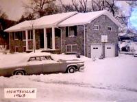
| This picture is taken on Homewood Drive in Huntsville by Bill and Ruthe Ragsdale, who were on their way back from a New Year's Eve party. (Courtesy Bill and Ruthe Ragsdale) |
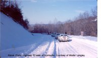
Snow covers US 72 west of Huntsville. Click on the image for full resolution. (Courtesy Walter Langley) |
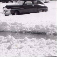
Snow covers everything in northeast Huntsville. Click on the image for full resolution. (Courtesy Helen Medlin) |
 |
 |
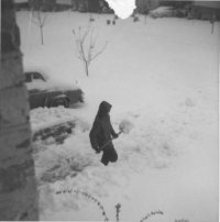 |
| Snow covers everything in northeast Huntsville. Click on the image for full resolution. (Courtesy Helen Medlin) |
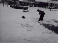
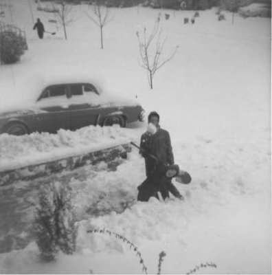
The Bagley family plays in and shovels snow at their home on Monte Sano Mountain. Click on the image for full resolution. (Courtesy H.D. Bagley) |
The Bagley family plays in and shovels snow at their home on Monte Sano Mountain. Click on the image for full resolution. (Courtesy H.D. Bagley) |
Weather Synopsis/Summary
After a cold air mass pushed into the southern Gulf on December 29th , cold air advection filtered around high pressure in the Midwest and into the Deep South. The upper level trough amplified and on December 30, 1963, a wave developed on a front in the central Gulf. The frontal wave matured and moved northeast into northern Florida on the 31st. At this time, the upper level trough developed two closed lows along the northern Gulf coast. Most of the snow fell in Huntsville between noon and midnight on the 31st as the surface low moved across northern Florida. As the low made its way up the Eastern seaboard, snow from wrap-around moisture continued to fall through the morning hours of January 1, 1964.
-William R. Schaub, Jr. (former WFO Huntsville senior meteorologist)
Weather Maps
 |
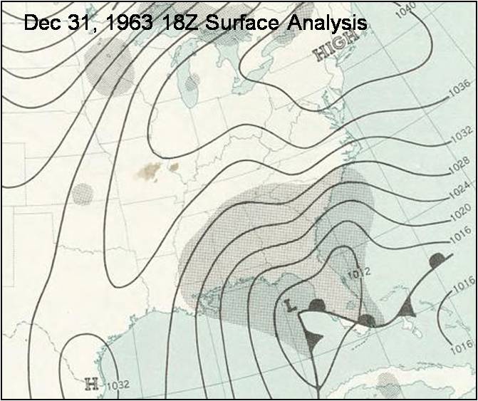 |
| A surface weather map from midnight New Year's Eve. At this point, the surface low is still position over the southern Gulf of America and precipitation is south of the area. Click on map for full resolution. |
A surface weather map from noon on New Year's Eve. The surface low has strengthened and advanced into the northeastern Gulf of America. Precipitation is now spreading north across the Tennessee Valley. Snow has just begun at Huntsville. Click on map for full resolution. |
 |
 |
| A surface weather map from midnight New Year's Day. The surface is now tracking along the Atlantic seaboard and has deepened further. Snow continues to fall over north Alabama and southern middle Tennessee, but is beginning to move out of the area. Click on map for full resolution. |
A 500mb map from New Year's Eve night. A significant negative-tilt trough is positioned over the southeastern United States, providing more than enough upper-level support for strengthening of the surface system. Click on map for full resolution. |
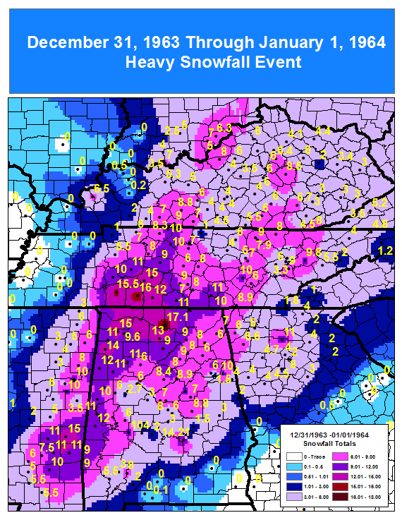
Snowfall Totals
Here is a listing of snowfall totals, as reported by cooperative observers across north Alabama and southern middle Tennessee.
| Location |
County |
Amount |
| Huntsville |
Madison |
17.1" |
| Madison |
Madison |
15" |
| Muscle Shoals |
Colbert |
15" |
| Russellville |
Franklin (AL) |
15" |
| Falkville |
Morgan |
13" |
| Red Bay |
Franklin (AL) |
13" |
| Moulton |
Lawrence |
12.5" |
| Decatur |
Morgan |
12" |
| Garden City |
Cullman |
12" |
| New Market |
Madison |
12" |
| Fayetteville |
Lincoln |
11" |
| Hodges |
Franklin (AL) |
11" |
| Coldwater |
Lincoln |
10.5" |
| Bridgeport |
Jackson |
10" |
| Albertville |
Marshall |
9.5" |
| Cullman |
Cullman |
9" |
| Guntersville |
Marshall |
9" |
| Crossville |
Dekalb |
8" |
| Valley Head |
Dekalb |
7" |
| Collinsville |
Dekalb |
6" |
| Fort Payne |
Dekalb |
6" |
Weather Observations
The following are hourly weather observations at the Huntsville-Madison County Airport.
| Date |
Time |
Sky Condition/Weather |
Temperature (°F) |
Dewpoint (°F) |
Wind (mph) |
Visibility (miles) |
| 31st |
Midnight |
Overcast |
28 |
13 |
NNE @ 13 |
10 |
| 31st |
1am |
Broken |
27 |
15 |
N @ 14 |
10 |
| 31st |
2am |
Overcast |
26 |
14 |
NNE @ 15 |
10 |
| 31st |
3am |
Overcast |
27 |
14 |
NNE @ 12 |
10 |
| 31st |
4am |
Overcast |
28 |
15 |
NNW @ 9 |
10 |
| 31st |
5am |
Overcast |
28 |
15 |
NNE @ 10 |
10 |
| 31st |
6am |
Overcast |
28 |
17 |
NNW @ 9 |
10 |
| 31st |
7am |
Overcast |
29 |
17 |
NNE @ 9 |
12 |
| 31st |
8am |
Overcast |
30 |
17 |
Calm |
10 |
| 31st |
9am |
Overcast |
31 |
18 |
NE @ 9 |
8 |
| 31st |
10am |
Overcast |
32 |
19 |
NNE @ 14 |
8 |
| 31st |
11am |
Overcast |
32 |
19 |
NNE @13 |
8 |
| 31st |
Noon |
Obscured/Light Snow |
32 |
20 |
ENE @ 15 |
2 |
| 31st |
1pm |
Obscured/Light Snow |
30 |
27 |
N @ 10 |
3/4 |
| 31st |
2pm |
Obscured/Light Snow |
29 |
27 |
N @ 15 |
3/4 |
| 31st |
3pm |
Overcast/Light Snow |
30 |
28 |
N @ 14 |
1 |
| 31st |
4pm |
Obscured/Snow |
30 |
28 |
NNE @ 16 |
1/2 |
| 31st |
5pm |
Obscured/Snow/Light Sleet/Fog |
29 |
28 |
NNE @ 29 |
1/4 |
| 31st |
6pm |
Obscured/Snow/Light Sleet/Fog |
29 |
27 |
NNE @ 30 |
1/4 |
| 31st |
7pm |
Obscured/Light Snow/Fog |
28 |
26 |
NNE @ 29 |
1/4 |
| 31st |
8pm |
Obscured/Light Snow/Light Sleet/Fog |
28 |
25 |
N @ 26 |
3/4 |
| 31st |
9pm |
Obscured/Light Snow/Light Sleet/Fog |
28 |
25 |
NNE@ 24 |
1 |
| 31st |
10pm |
Obscured/Light Snow/Light Sleet/Fog |
29 |
28 |
NNE @ 14 |
1/4 |
| 31st |
11pm |
Obscured/Light Snow/Fog |
28 |
27 |
NNE @ 15 |
1/2 |
| 1st |
Midnight |
Obscured/Light Snow/Fog |
28 |
27 |
NNE @ 16 |
1/2 |
| 1st |
1am |
Overcast/Light Snow/Fog |
28 |
26 |
NW @ 12 |
3 |
| 1st |
2am |
Obscured/Light Snow/Fog |
27 |
24 |
NNW @ 12 |
1 1/2 |
| 1st |
3am |
Obscured/Light Snow/Fog |
26 |
24 |
NNW @ 10 |
3/4 |
| 1st |
4am |
Obscured/Light Snow/Fog |
26 |
23 |
NW @ 9 |
1 1/2 |
| 1st |
5am |
Obscured/Light Snow/Fog |
25 |
23 |
NW @ 9 |
1 1/2 |
| 1st |
6am |
Overcast/Light Snow/Fog |
25 |
23 |
WNW @ 10 |
2 1/2 |
| 1st |
7am |
Overcast/Light Snow/Fog |
25 |
22 |
WNW @ 9 |
5 |
| 1st |
8am |
Overcast/Light Snow |
25 |
22 |
W @ 7 |
8 |
| 1st |
9am |
Overcast/Light Snow |
26 |
22 |
W @ 12 |
7 |
| 1st |
10am |
Overcast/Light Snow |
28 |
24 |
WNW @ 10 |
2 1/2 |
| 1st |
11am |
Overcast/Light Snow |
29 |
25 |
WSW @ 14 |
2 1/2 |
| 1st |
Noon |
Overcast/Light Snow |
30 |
24 |
WSW @ 14 |
5 |
| 1st |
1pm |
Overcast/Haze |
31 |
24 |
W @ 13 |
6 |
| 1st |
2pm |
Scattered |
33 |
23 |
W @ 8 |
7 |
| 1st |
3pm |
Thin Scattered |
34 |
23 |
W @ 8 |
10 |
| 1st |
4pm |
Thin Scattered |
33 |
23 |
SW @ 5 |
10 |
| 1st |
5pm |
Thin Scattered |
29 |
22 |
SSW @ 6 |
10 |
| 1st |
6pm |
Clear |
28 |
17 |
WSW @ 8 |
10 |
| 1st |
7pm |
Clear |
27 |
17 |
SSW @ 7 |
12 |
| 1st |
8pm |
Clear |
21 |
16 |
SE @ 12 |
12 |
| 1st |
9pm |
Clear |
20 |
15 |
SSE @ 8 |
10 |
| 1st |
10pm |
Clear |
23 |
15 |
SSE @ 8 |
12 |
| 1st |
11pm |
Clear |
22 |
14 |
SSE @ 6 |
12 |
| 2nd |
Midnight |
Clear |
21 |
14 |
SSE @ 7 |
12 |
Feedback
Do you have memories from the New Year's storm of 1963/1964? If you have stories or photos from the winter storm that you're willing to share with us, we'd love to hear from you! For more information on how to contact us, visit this page.
|


 Local Radar
 Weather Map