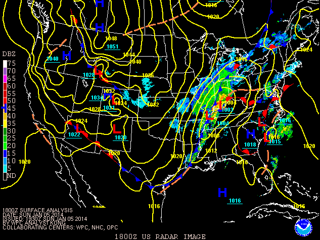
Surface Map Valid at 1:00 PM January 5, 2014.
| What Caused This Event? | Snowfall Overview | Cold Temperatures |
| Info from Nearby Offices | List of Snowfall Reports |
A powerful storm system brought heavy snow and near blizzard conditions to much of central Indiana on January 5, with a mix of rain and snow across southeast sections of the area. After the snow diminished during the evening, arctic air plunged into the area on strong winds. Temperatures plummeted and significant blowing and drifting of snow occurred. Temperatures remained below zero for over 24 hours at many locations, with wind chills around 40 below zero at times. Temperatures reached levels that had not been seen in 20 years. The snow and cold created dangerous travel conditions across much of Indiana and surrounding areas. Sections of interstates were closed down, and travel was restricted to emergency personnel only. Schools were closed for a week across parts of central Indiana.

Water vapor satellite image shows large view
of system that brought the cold air. White lines
show 500mb heights. Yellow arrow shows basic flow
around the system. Click to enlarge.
The jet stream dove south into the southern United States, allowing cold air straight from the Arctic to flow south into the USA. (For information on the "polar vortex", please visit this climate.gov article). This cold air interacted with plentiful moisture being drawn northward with an area of low pressure at the surface. The result was heavy snow for several hours across the northwest half of central Indiana. Across the southeast part of the area, warmer air moved north and allowed for a period of rain. This cut down on snow amounts. As strong high pressure moved in behind the low pressure, winds increased across the area. Gusts of 30 to 40 mph were common Sunday night, resulting in blowing and drifting of the snow that fell. Gusty winds continued into January 6, creating dangerous wind chills.
Snowfall of 8 to 14 inches was common across areas generally along and north of a Terre Haute to New Castle line. Amounts dropped quickly to the south and east of this line due to warmer air allowing rain to fall for several hours. Areas that received heavy snow saw snow falling at a rate of an inch or more per hour during the height of the storm. At Indianapolis, snow fell at the rate of at least an inch per hour during the 10:00 AM to 3:00 PM time frame on January 5. Snowfall diminished by late afternoon but lighter snows continued into the evening. At Indianapolis, the 11.4 inches of snow that fell on January 5 was the second highest calendar day snowfall since records began, and that amount was a new record snowfall for the January 5 date. The Indianapolis record for most snowfall in a calendar day is 12.1 inches on March 19, 1906. At Indianapolis, only two other days in January have ever had greater than 10 inches of snow accumulate in 1 day: January 15, 1965 and January 26, 1978 (during the blizzard of '78).
Gusty winds ushering in the colder air brought blowing and drifting snow. Visibility was reduced in blowing snow across many areas through the day of January 6. This resulted in drifts of several feet at some locations. The snow and lowered visibility caused some roads to be shut down across parts of Indiana. Interstate 65 was shut down north of Lafayette. Some state highways and US highways were also closed. Many counties in Indiana declared travel warnings, meaning that only emergency vehicles were allowed on the roads.
A list of snowfall reports from central Indiana is at the end of this page. Below are some images related to the snowfall. Click any image to enlarge.
 |
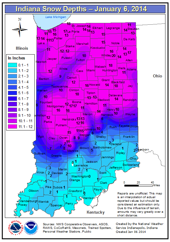 |
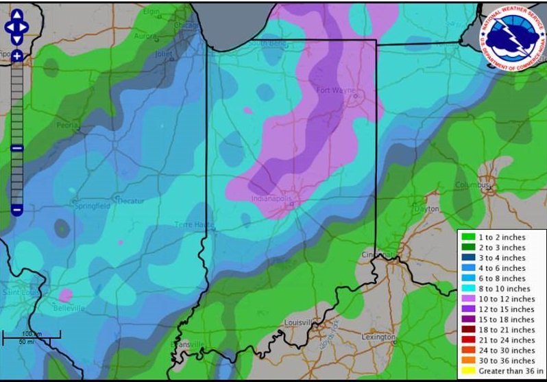
| 72 hour snowfall map for January 5 - January 8. | Indiana snow depth map as of 7:00 AM January 6. |
 |
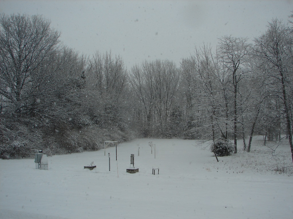 |
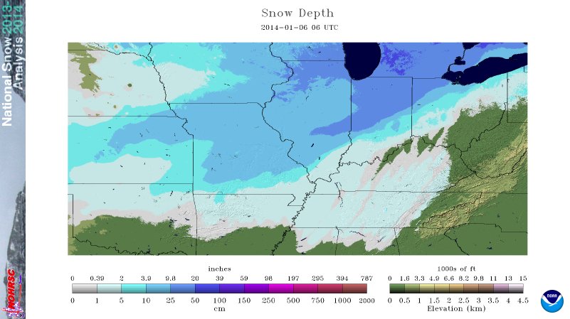
| Midwest snow depth map as of January 6 at 1:00 AM. Map courtesy of National Operational Hydrologic Remote Sensing Center | View from NWS Indianapolis at 10:15 AM January 5. |
 |
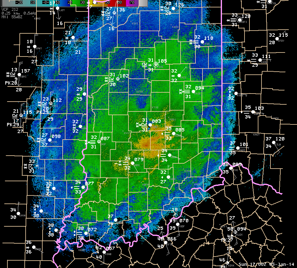 |
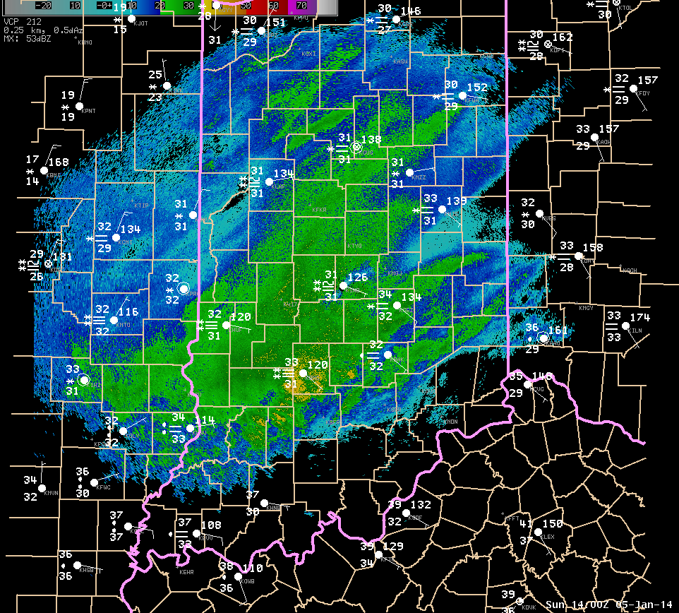
| Radar image and surface data plot from near 9:00 AM January 5. | Radar image and surface data plot from near 12:00 PM January 5. |
 |
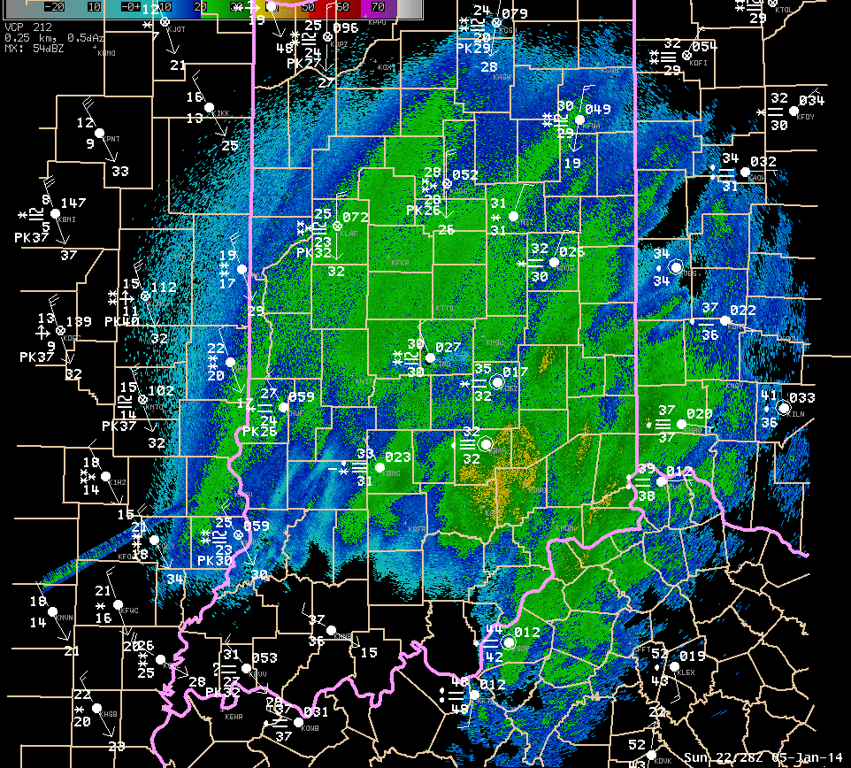 |
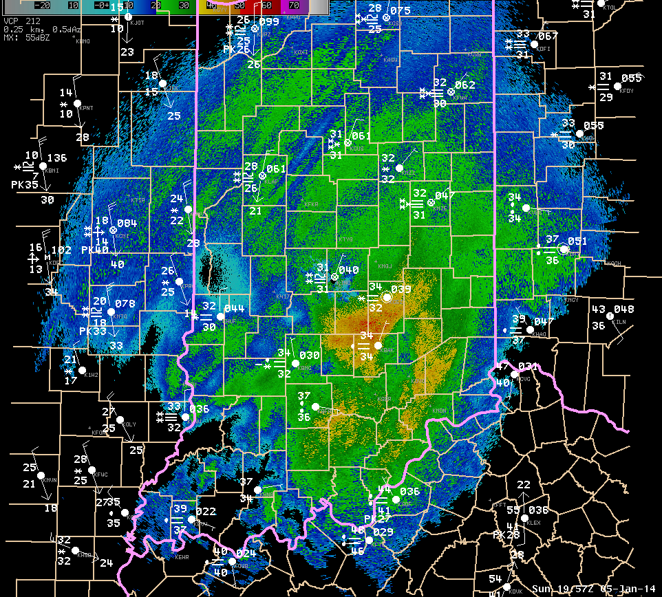
| Radar image and surface data plot from near 3:00 PM January 5. | Radar image and surface data plot from near 5:30 PM January 5. |
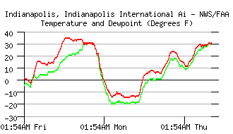
7 day plot of temperature and dewpoint at Indianapolis ending early January 10.
As arctic air flowed into the area, temperatures fell quickly during the evening of January 5 and into January 6. Readings bottomed out colder than 10 below zero across most of the area that saw significant snow. These temperatures often were the coldest seen since January 1994. Temperatures remained below zero for well over 24 hours at many locales. With gusty winds continuing through January 6, wind chills fell into the 30 to 45 below zero range for prolonged periods of time. The following table summarizes some temperature facts for sites across central Indiana, based on hourly observations at the site. Temperature and wind information was missing at Lafayette for several hours during the event.
| Observation Site | Hours Below Zero | Low temperature January 6 | Low temperature January 7 | Wind Chills (based on sustained winds) |
| Indianapolis | 34 | -15 | -14 | -30 or colder from 4:00 AM Jan 6 to 10:00 AM Jan 7 |
| Lafayette | ~35 | N/A | -14 | N/A |
| Muncie | 34 | -13 | -14 | -30 or colder from 6:00 AM Jan 6 to 9:00 AM Jan 7 |
| Terre Haute | 34 | -14 | -15 | -25 or colder from 3:00 AM Jan 6 to 10:00 AM Jan 7 |
| Bloomington | 31 | -11 | -9 | -25 or colder from 7:00 AM Jan 6 to 12:00 AM Jan 7 |
Information from Nearby Offices
THE TOTALS BELOW ARE SEPARATED INTO SNOW...AND ICE AND SLEET
CATEGORIES...THEN BY AMOUNT...AND ARE NOT NECESSARILY THE
FINAL AMOUNT FOR EACH LOCATION.
SNOW REPORTS LISTED BY AMOUNT
INCHES LOCATION ST COUNTY TIME
------ ----------------------- -- -------------- -------
15.00 TIPTON IN TIPTON 1129 PM
14.00 LEBANON IN BOONE 1138 PM
13.00 WESTFIELD IN HAMILTON 0649 PM
12.00 FRANKFORT IN CLINTON 1000 PM
STORM TOTAL
12.00 2 NE CARMEL IN HAMILTON 1000 PM
STORM TOTAL
12.00 MUNCIE IN DELAWARE 0854 PM
12.00 ANDERSON IN MADISON 0820 PM
FAR NORTHERN ANDERSON. REPORT RECEIVED VIA
TWITTER.
12.00 3 NE MANILLA IN RUSH 0800 PM
12.00 4 N FRANKFORT IN CLINTON 0630 PM
12.00 WHITESTOWN IN BOONE 0516 PM
STORM TOTAL THROUGH 515 PM. REPORT RECEIVED
VIA TWITTER.
11.90 2 S CASTLETON IN MARION 1240 AM
STORM TOTAL THROUGH MIDNIGHT. 1.36 INCH WATER
EQUIVALENT. SNOW DEPTH 13 INCHES.
11.80 2 SE BROWNSBURG IN HENDRICKS 0947 PM
11.60 2 NE GREENCASTLE IN PUTNAM 0839 PM
11.50 NOBLESVILLE IN HAMILTON 0904 PM
11.50 6 W LEBANON IN BOONE 0336 PM
11.40 INDIANAPOLIS INT`L AIRP IN MARION 1200 AM
TORM TOTAL THROUGH MIDNIGHT AT NWS INDIANAPOLIS.
11.20 WHITESTOWN IN BOONE 0620 PM
11.00 CRAWFORDSVILLE IN MONTGOMERY 0730 PM
REPORT RECEIVED VIA TWITTER.
11.00 GREENWOOD IN JOHNSON 0709 PM
11.00 2 SE BROWNSBURG IN HENDRICKS 0630 PM
11.00 ALEXANDRIA IN MADISON 0600 PM
NORTHERN ALEXANDRIA. REPORT RECEIVED VIA
TWITTER.
11.00 THORNTOWN IN BOONE 0520 PM
11.00 BAINBRIDGE IN PUTNAM 0242 PM
11.00 2 E JAMESTOWN IN BOONE 0146 PM
10.80 2 SW MICHIGANTOWN IN CLINTON 0420 PM
10.50 MUNCIE IN DELAWARE 1127 PM
WEST SIDE OF MUNCIE.
10.50 INDIANAPOLIS INT`L AIRP IN MARION 0700 PM
STORM TOTAL THROUGH 7 PM AT NWS INDIANAPOLIS.
10.50 AVON IN HENDRICKS 0614 PM
STORM TOTAL THUS FAR. REPORT RECEIVED VIA
TWITTER.
10.50 KOKOMO IN HOWARD 0500 PM
REPORTED FROM WEST KOKOMO. REPORT RECEIVED
VIA FACEBOOK.
10.10 1 N FISHERS IN HAMILTON 1131 PM
TOTAL SNOWFALL OVER THE PAST 16 HOURS
10.00 4 NNE TERRE HAUTE IN VIGO 1220 AM
STORM TOTAL SNOWFALL JUST EAST OF SKY KING
AIRPORT.
10.00 3 N BLOOMINGDALE IN PARKE 0815 PM
10.00 WEST LAFAYETTE IN TIPPECANOE 0633 PM
10.00 1 N TERRE HAUTE IN VIGO 0517 PM
REPORTED FROM JUST NORTH OF TERRE HAUTE.
10.00 CLOVERDALE IN PUTNAM 0449 PM
ESTIMATED REPORT FROM NORTH SIDE OF
CLOVERDALE. REPORT RECEIVED VIA TWITTER.
10.00 FRANKFORT IN CLINTON 0434 PM
10.00 DANVILLE IN HENDRICKS 0239 PM
9.80 LAWRENCE IN MARION 0646 PM
9.80 2 SSE BROWNSBURG IN HENDRICKS 0337 PM
9.80 LEBANON IN BOONE 0251 PM
9.80 LEBANON IN BOONE 0240 PM
9.60 MUNCIE IN DELAWARE 1207 AM
STORM TOTAL SO FAR
9.60 INDIANAPOLIS INT`L AIRP IN MARION 0600 PM
STORM TOTAL THUS FAR AT NWS INDIANAPOLIS.
9.50 INDIANAPOLIS IN MARION 0801 PM
FAR EASTSIDE INDIANAPOLIS.
9.50 INDIANAPOLIS IN MARION 0739 PM
9.50 GREENWOOD IN JOHNSON 0733 PM
REPORT RECEIVED VIA TWITTER.
9.50 GOSPORT IN OWEN 0609 PM
STORM TOTAL THUS FAR. REPORT RECEIVED VIA
TWITTER.
9.50 CICERO IN HAMILTON 0241 PM
9.30 TERRE HAUTE IN VIGO 0509 PM
REPORT FROM SOUTHWEST TERRE HAUTE NEAR I 70
AND SR 63.
9.00 MUNCIE IN DELAWARE 0704 PM
9.00 MUNCIE IN DELAWARE 0700 PM
9.00 MARTINSVILLE IN MORGAN 0630 PM
9.00 NOBLESVILLE IN HAMILTON 0558 PM
REPORTED FROM CUMBERLAND RD AND GREENFIELD
AVE.
9.00 2 NE CARMEL IN HAMILTON 0544 PM
REPORTED NEAR HAZEL DELL AND RIVER RD.
9.00 3 SSW ATTICA IN FOUNTAIN 0540 PM
9.00 THORNTOWN IN BOONE 0111 PM
8.80 CICERO IN HAMILTON 0709 PM
8.80 4 ESE BEECH GROVE IN MARION 0512 PM
MEASUREMENT TAKEN IN WANAMAKER. REPORT
RECEIVED VIA TWITTER.
8.50 EAGLE CREEK RESERVOIR IN MARION 0505 PM
STORM TOTAL THROUGH 5 PM. REPORT RECEIVED VIA
TWITTER.
8.50 2 SSE BROWNSBURG IN HENDRICKS 0220 PM
8.20 BROOKLYN IN MORGAN 0600 PM
8.20 MCCORDSVILLE IN HANCOCK 0555 PM
8.20 2 S CASTLETON IN MARION 0400 PM
STORM TOTAL THUS FAR...0.71 INCH LIQUID
EQUIVALENT. SNOW DEPTH 10 INCHES.
8.00 ELLETTSVILLE IN MONROE 0905 PM
SOUTHEAST ELLETTSVILLE.
8.00 YORKTOWN IN DELAWARE 0626 PM
8.00 3 NNW YORKTOWN IN DELAWARE 0611 PM
8.00 ANDERSON IN MADISON 0600 PM
DOWNTOWN ANDERSON.
8.00 MUNCIE IN DELAWARE 0505 PM
8.00 ANDERSON IN MADISON 0450 PM
ESTIMATED REPORT FROM WEST SIDE OF ANDERSON.
REPORT RECEIVED VIA TWITTER.
8.00 LEBANON IN BOONE 0352 PM
8.00 TIPTON IN TIPTON 0222 PM
8.00 KOKOMO IN HOWARD 0203 PM
7.90 INDIANAPOLIS INT`L AIRP IN MARION 0306 PM
7.80 2 WSW WAVERLY IN MORGAN 0813 PM
7.80 FISHERS IN HAMILTON 0251 PM
7.80 2 SW MICHIGANTOWN IN CLINTON 0130 PM
7.50 BEECH GROVE IN MARION 0616 PM
7.50 PENDLETON IN MADISON 0607 PM
REPORT RECEIVED VIA TWITTER.
7.50 AVON IN HENDRICKS 0245 PM
7.50 TERRE HAUTE IN VIGO 0236 PM
7.50 INDIANAPOLIS IN MARION 0156 PM
7.30 ANDERSON IN MADISON 0500 PM
DOWNTOWN ANDERSON.
7.00 ELLETTSVILLE IN MONROE 0436 PM
7.00 3 N BLOOMINGDALE IN PARKE 0325 PM
7.00 INDIANAPOLIS IN MARION 0313 PM
6.80 2 SE BROWNSBURG IN HENDRICKS 0109 PM
6.70 INDIANAPOLIS INT`L AIRP IN MARION 0205 PM
REPORT FROM NATIONAL WEATHER SERVICE.
6.60 1 N FISHERS IN HAMILTON 0254 PM
6.60 2 WSW WAVERLY IN MORGAN 0235 PM
6.50 3 N BARGERSVILLE IN JOHNSON 0500 PM
6.50 BROOKLYN IN MORGAN 0259 PM
6.50 WEST LAFAYETTE IN TIPPECANOE 0234 PM
6.40 WESTFIELD IN HAMILTON 0238 PM
6.00 4 NE WAVERLY IN JOHNSON 0432 PM
6.00 BALL STATE UNIVERSITY IN DELAWARE 0339 PM
TREES ARE BENDING FROM THE WEIGHT OF THE WET
SNOW.
6.00 BEECH GROVE IN MARION 0256 PM
6.00 WHITESTOWN IN BOONE 0237 PM
6.00 10 NW INDIANAPOLIS IN MARION 0140 PM
REPORT FROM TRADERS POINT.
5.50 LAWRENCE IN MARION 0204 PM
5.50 CICERO IN HAMILTON 0203 PM
5.50 4 SSE GREENCASTLE IN PUTNAM 0145 PM
5.50 INDIANAPOLIS INT`L AIRP IN MARION 0136 PM
REPORT FROM NATIONAL WEATHER SERVICE.
5.50 1 SSE BROWNSBURG IN HENDRICKS 1210 PM
5.00 1 NW PLAINFIELD IN HENDRICKS 0244 PM
5.00 3 NW FISHERS IN HAMILTON 0153 PM
5.00 10 NW INDIANAPOLIS IN MARION 1250 PM
REPORT FROM 71ST AND LAFAYETTE.
5.00 3 NW ZIONSVILLE IN BOONE 1244 PM
4.70 2 S CASTLETON IN MARION 0123 PM
4.50 4 NE WAVERLY IN JOHNSON 0200 PM
4.50 NOBLESVILLE IN HAMILTON 0156 PM
4.50 WESTFIELD IN HAMILTON 1245 PM
4.50 TERRE HAUTE IN VIGO 1226 PM
4.50 GOSPORT IN OWEN 1026 AM
4.30 ANDERSON IN MADISON 0157 PM
4.30 2 SE BROWNSBURG IN HENDRICKS 1114 AM
4.00 2 NE CARMEL IN HAMILTON 0110 PM
4.00 CICERO IN HAMILTON 1256 PM
4.00 8 W FRANKFORT IN CLINTON 1207 PM
3.80 INDIANAPOLIS INT`L AIRP IN MARION 1209 PM
REPORT FROM NATIONAL WEATHER SERVICE OFFICE.
3.70 BROOKLYN IN MORGAN 1249 PM
3.40 2 WSW WAVERLY IN MORGAN 1210 PM
3.30 MUNCIE IN DELAWARE 0137 PM
3.30 3 N WEST LAFAYETTE IN TIPPECANOE 1206 PM
3.30 7 N SPENCER IN OWEN 1200 PM
3.20 BEECH GROVE IN MARION 0118 PM
3.00 FISHERS IN HAMILTON 0140 PM
3.00 ANDERSON IN MADISON 0112 PM
3.00 3 N BARGERSVILLE IN JOHNSON 1239 PM
3.00 LEBANON IN BOONE 1121 AM
3.00 TERRE HAUTE IN VIGO 1030 AM
3.00 THORNTOWN IN BOONE 0949 AM
2.70 MCCORDSVILLE IN HANCOCK 1216 PM
2.60 INDIANAPOLIS INT`L AIRP IN MARION 1104 AM
REPORT FROM THE NATIONAL WEATHER SERVICE
INDIANAPOLIS.
2.50 LAFAYETTE IN TIPPECANOE 1015 AM
2.00 3 S BLOOMFIELD IN GREENE 1100 PM
2.00 NOBLESVILLE IN HAMILTON 1122 AM
2.00 CICERO IN HAMILTON 1054 AM
2.00 TIPTON IN TIPTON 0948 AM
2.00 TERRE HAUTE IN VIGO 0830 AM
1.80 WESTFIELD IN HAMILTON 1034 AM
1.80 3 NW ZIONSVILLE IN BOONE 0926 AM
1.8 INCHES OF SNOW IN BETWEEN ZIONSVILLE AND
WHITESTOWN.
1.50 INDIANAPOLIS INT`L AIRP IN MARION 1000 AM
1.5 INCHES SNOWFALL AT THE NATIONAL WEATHER
SERVICE OFFICE.
1.50 WESTFIELD IN HAMILTON 0931 AM
1.50 LAFAYETTE IN TIPPECANOE 0905 AM
1.40 2 S CASTLETON IN MARION 1014 AM
1.40 2 WSW WAVERLY IN MORGAN 1000 AM
1.30 BRAZIL IN CLAY 0852 AM
1.20 SEYMOUR IN JACKSON 0900 PM
1.00 SHELBYVILLE IN SHELBY 0645 PM
1.00 MUNCIE IN DELAWARE 1105 AM
1.00 NOBLESVILLE IN HAMILTON 1021 AM
1.00 CLOVERDALE IN PUTNAM 0833 AM
0.90 BLOOMINGTON IN MONROE 1038 AM
0.80 GOSPORT IN OWEN 0910 AM
0.50 SHELBYVILLE IN SHELBY 1053 AM
SNOW MIXED WITH SLEET AND RAIN.
0.50 FRANKLIN IN JOHNSON 0903 AM
0.50 MOORESVILLE IN MORGAN 0835 AM
0.50 INDIANAPOLIS IN MARION 0834 AM
0.30 ANDERSON IN MADISON 1124 AM

