 |
The Monticello Tornado
|
 |
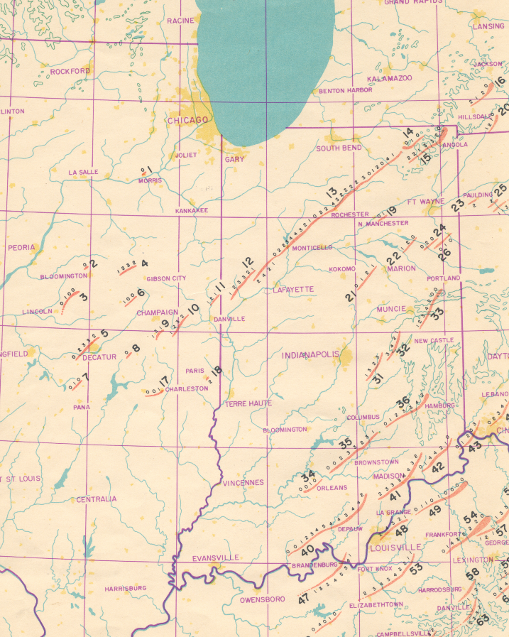
April 3, 1974 will always be remembered as the date of the worst tornado outbreak during the 20th century. The “Super Outbreak,” as it is commonly referred to, featured 148 tornadoes that occurred in a 24 hour period from 1:00 PM EST April 3rd to 1:00 PM EST on April 4 th. The combined path length of all tornadoes during this period was approximately 2500 miles with 315+ fatalities, over 5000 injuries, and an estimated $600+ million loss (in 1974 dollars). Not only was the eastern US devastated by tornadoes, but high winds and very large hail accompanied many thunderstorms that day.
One of the most destructive tornadoes (including the longest path length) of any tornado during the outbreak was the Monticello Tornado. The Monticello Tornado was spawned by an intense supercell thunderstorm. The same thunderstorm produced a series of 9 tornadoes across Illinois and Indiana, known as the Monticello tornado family. Tornadoes included in the Monticello tornado family were: Owaneco, Pierson, Tolono, Homer Lake, and Bismarck in Illinois with Rainsville, Otterbein (originally classified as part of the Monticello tornado track), Monticello, and Plato in Indiana (tornadoes 7-14 in the figure below). The Monticello tornado family was responsible for 18 deaths across Illinois and Indiana, several injuries, and an enormous amount of damage in excess of $100 million (1974 dollars). The Monticello tornado was originally rated as having an impressive 121 mile path length from southeast Benton County to La Grange County (IN). However, further analysis and research by Dr. Ted Fujita indicated that this was not the case and the Monticello tornado was officially reclassified as two separate tornadoes. Dr. Fujita discovered that a strong “twisting” downdraft from the parent thunderstorm (most likely the thunderstorm’s rear flank downdraft) disrupted the storm’s inflow, subsequently allowing the initial tornado to dissipate. As soon as the first tornado dissipated, another touched down almost immediately and nearly along the same path. So, to the casual observer it appeared as a single tornado track. In reality, as the first of the tornado lifted, the second touched down, just west of Brookston. The reclassification of the tornado still documents the Monticello Tornado as having a 109 mile path length with a path width of up to a half mile, retaining the title as the longest track tornado during the Super Outbreak of 1974.
 |
|
Original tornado track map published by Dr. Ted Fujita (Final Edition) from April 1975.
|
 |
|
The "twisting downburst" described above. The downburst winds disrupted the tornado's inflow, allowing it to temporarily lift southwest of Chalmers. (From Manual of Downburst Identification for Project NIMROD, Fujita 1978)
|
The Monticello Tornado was born in a field just west of Brookston (in southern White County), at approximately 4:50pm. The twister narrowly missed Chalmers and soon after, took a direct hit on Monticello, passing through the heart of the city. The storm then proceeded northeast passing through rural farmland and destroying or heavily damaging numerous farmsteads. The next significant damage occurred in the towns of Rochester and Talma, where the western portion of Rochester received extensive damage with Talma being almost completely destroyed. Traveling northeast into Kosciusko County, the tornado produced significant damage from Atwood to Leesburg, after which the tornado crossed Dewart Lake and Lake Wawasee, continuing the trail of damage and destruction. Proceeding to the northeast, it passed between Ligonier and Topeka. Numerous buildings were heavily damaged including the Monsanto plant and Perry School. The parent thunderstorm’s rear flank downdraft led to the tornado’s demise just southeast of Lagrange near Oliver Lake, ending the 109 mile path of death and destruction. Another weaker F1 tornado, which touched down just southwest of Plato, quickly dissipated 8 miles to the northeast near Mongo, thus ending the wrath of the Monticello tornado family. Other tornadoes occurred across the area that day affecting portions of Indiana, Illinois, Michigan, Ohio, as well as eight other states. Two other significant tornadoes that affected what is now the Northern Indiana forecast area were the Angola and Hillsdale tornadoes.
The average speed of the tornado was approximately 55 mph, with a path width of up to one half mile. It was originally classified as an F4 tornado, primarily based on damage in the Monticello area, and is now referred to as an EF4 on today’s revised Fujita Scale (wind speeds of 166-200 mph). No known pictures of the storm or tornado exist, just pictures of the aftermath. This is believed to be due to the fact that eyewitnesses did not recognize the tornado due to being concealed by rain and due its sheer size. Many people reported seeing “a wall of black clouds,” and did not even realize a tornado was taking aim on them, expecting to see the classic “funnel shape.”
Unfortunately, the tornado had a major impact to portions of Northern Indiana, as 16 people lost their lives (8 White, 6 Fulton, 1 Kosciusko, and 1 Noble), over 400 people were injured, and damage was estimated at well over 100 million dollars (over 420 million in today’s dollars), ranking the tornado number 20 of the top damaging tornadoes of all time since 1890 (National Severe Storms Laboratory). The hardest hit town was Monticello, where the tornado swept through the central business district (figure below) killing 8, injuring over 350, and damaging or destroying nearly all of the heart of downtown including more than 40 businesses. Damage was estimated at over $100 million in Monticello. The historic White County courthouse, a masonry and steel building built in 1894 and located in the center of town, took a direct hit from the tornado. The building incurred such extreme damage that the entire roof was removed and the clock tower toppled. The building had to be demolished. Damage from light to severe was experienced throughout town, with numerous homes afflicted. Another testament to the strength of the wind was evidenced by the destruction of the Penn Central Railroad bridge. The 630 ft six span bridge was almost completely destroyed, as 4 of the 6 spans (weighing 115 tons each) were lifted and carried 40 feet before landing in Upper Freeman Lake. Railroad ties from the bridge weighing 250 pounds each were also found in farm fields 10 miles away.
 |
|
Track map from "Engineering Aspects of the Tornadoes of April 3 - 4, 1974", by Mehta, K. C. et al.
|
 |
|
Radar imagery from Marseilles, IL (MMO) as the tornado was approaching Monticello. The tornado struck downtown at 5:17 PM (1717) local time. The "T" on the image indicates the location of the tornado. (Image courtesy of Dr. Greg Forbes) (Click on the image for a larger version)
|
 |
|
Satellite loop from April 3rd 1974. (Click on the image for a larger version)
|
Portions of Fulton County including the town of Rochester were also hit hard by the destructive tornado. Some of the worst damage in the county occurred in the town of Rochester where numerous buildings were damaged or destroyed. Below is a summary article from a special edition of the Rochester Sentinel.
Early damage survey remains the best
On Thursday morning, April 4 – less than 23 hours after the tornado hit Fulton county – Mayor Wayne Hittle was being deluged by requests for information about the extent of the damage.
He called upon the Ouibachi Development Commission – the Region 5 multi-county planning organization which Rochester recently joined.
At 10 a.m. Thursday, two Ouibachi representatives climbed in a state police car and covered about 80 miles in five hours. They returned to City Hall at 3 p.m.; it took another four hours for these men and the mayor to compile the data.
The ensuing report, albeit made hastily and under pressure, remains today the only comprehensive collection of information about the physical damage of the April 3 tornado in Fulton County.
It notes that the figures for Monticello road and for Fulton avenue north of the Eric Lackawanna railroad are low because of the difficulty in determining just where houses and other buildings had been located before the twister struck.
The report shows the following:
For Fulton County as a whole – 114 houses destroyed, 185 houses damaged, 34 mobile homes destroyed, seven mobile homes damaged, four churches destroyed, seven industrial buildings damaged, two schools damaged, 45 barns destroyed, 11 barns damaged, 64 other structures destroyed, 19 other structures damaged, one motel destroyed, 90 automobiles and trucks damaged or destroyed.
The report also lists “immense tree damage, much power and telephone line damage, much fence damage, gas line damage, some street damage, livestock damage and farm equipment damaged.”
A breakdown of damage shows:
In city of Rochester – 29 houses destroyed, 88 houses damaged, one school damaged, 14 other structures destroyed, six other structures damaged, 40 automobiles destroyed or damaged. Total structures damaged or destroyed – 178.
In Talma– 16 houses destroyed, 38 houses damaged, eight mobile homes destroyed, two mobile homes damaged, two churches destroyed, one school damaged, five barns destroyed, three barns damaged, five other structures destroyed, 10 other structures damaged, 10 automobiles destroyed or damaged. Total structures destroyed or damaged – 99.
In Fulton County other than in Rochester and Talma – 69 houses destroyed (31 north of Ind. 14 and west of Rochester city limits, 17 on Old U.S. 31, five on County Road 200 North, seven on Ind. 25, four on Lucas street and five in Wayne township), 56 houses damaged, 40 barns destroyed, eight barns damaged, two churches destroyed, 31 mobile homes destroyed or damaged, 25 other structures destroyed, three other structures damaged.
Some of the hardest hit areas in the Lakes region of Kosciusko and Noble counties were the towns of Atwood, Leesburg, and Ligonier, where numerous farms, homes, and businesses were damaged or destroyed. The tornado passed across Dewart and Wawasee Lakes toppling countless numbers of trees.
Damage pictures from the tornado can be found here. Pictures are sorted by location and source. Updates to this page will be ongoing as photos become available.
An interesting yet scary aspect of the Super Outbreak was the sheer number of schools that were either damaged or destroyed. Thankfully the tornadoes struck after schools had been dismissed for the day. The Monticello tornado alone damaged or destroyed 6 schools along its path: Meadowlawn, Twin Lakes and Roosevelt schools in Monticello, Riddle School in Rochester, Talma School in Talma, and Perry School in Ligonier. Below is an excerpt from Engineering Aspects of the Tornadoes of April 3-4 1974 by Mehta, KC et al describing some of the damage inflicted on schools in Monticello.
“Three schools on the southwestern edge of Monticello experienced the effects of a tornado that passed across the town late in the afternoon of April 3. Meadowlawn Elementary School caught the full effects of the tornado. Twin Lakes High School felt severe, but not direct, effects next. Roosevelt Junior High School was located on the left edge of the advancing tornado and was less severely damaged.
The Meadowlawn School...has a principle main hallway oriented east-west, with classrooms on either side. The tornado slammed directly into the school from across an open field. Classrooms on the south side of the hallway were extensively damaged -- window walls demolished and open web steel roof joists and roof were uplifted. Classrooms on the north side of the hallway were virtually undamaged. The principle hallway was undamaged except for the west glass doors which were broken. The hallway would have been a safe haven for school children.
The Twin Lakes High School is oriented such that the southwestern-most corner of the complex is a gymnasium. This corner of the complex is approximately 1000 feet north and east of the Meadowlawn School. Damage to the Twin lakes school was concentrated in the gymnasium area (the gym proper and adjacent one-story dressing rooms) and in classrooms on the west side of the complex. Unreinforced, non-load bearing masonry walls (12 in. concrete block with brick facing), which formed the south and west external walls of the gymnasium (extending from the roof of the first floor dressing rooms to the roof level of the gym) toppled outward. Although atmospheric pressure change inducing outward acting pressure may have been a factor in these wall failures, there is evidence of lateral movement of the gymnasium structural frame (steel trusses on beams which frame to pipe columns; column height approximately 30 ft.) within the masonry "shell". The evidence (vertically cracked interior masonry walls at the locations of pipe columns) suggests that wind loads induced a lateral translation of the structural frame to the northeast and, upon rebounding, the frame pushed the south and west unreinforced masonry walls outward.
A significant missile incident at the Twin Lakes school involves a steel wide-flange beam which formed the roof support along the western edge of a second story classroom. This beam was lifted over the school building as the second story roof failed upward, and fell on the opposite (east) side of the building in the school yard.
As in the Meadowlawn School, hallways would have proved to be safe havens for school children in the Twin Lakes school. The school tornado plan called for building occupants to move to first floor hallways away from outside doors; this plan would have assured protection of building occupants, if warning times would have permitted planned movements of people.”
The Roosevelt Junior High School, located to the north and west of the Twin Lakes School sustained less damage than the other two Monticello schools. The significant documentation item from this school is a barograph recording taken on a lower floor in the north central portion of the building (image below). The barograph reading was from Joel Storm's classroom. A barograph records pressure over a time period. Fluctuations in pressure as a function of time can be observed and documented. This information is a very valuable observational tool, which can be useful in research. In the trace below, the general falling pressure trend is related to the pressure falls associated with the approach of large scale low pressure. The rapid pressure jump annotated on the graph is the extreme pressure rise associated with the passage of the supercell thunderstorm.


