
A storm and trailing cold front will continue to slowly move through the Gulf Coast and Southeast U.S. through this weekend with widespread rain showers and isolated thunderstorms. A fast-moving clipper storm may bring several inches of snow to the north-central Plains, Midwest, eastern Great Lakes, and Northeast regions this weekend. Read More >
Jackson, KY
Weather Forecast Office
 |
 |
 |
 |
523
WWUS83 KJKL 070735
SPSJKL
Special Weather Statement
National Weather Service Jackson KY
235 AM EST Sun Dec 7 2025
KYZ044-050>052-058>060-068-069-088-104-106>120-071745-
Fleming-Montgomery-Bath-Rowan-Estill-Powell-Menifee-Rockcastle-
Jackson-Harlan-Elliott-Morgan-Johnson-Wolfe-Magoffin-Floyd-Lee-
Breathitt-Knott-Owsley-Perry-Clay-Leslie-Letcher-Martin-Pike-
Including the cities of Flemingsburg, Camargo, Jeffersonville,
Mount Sterling, Owingsville, Morehead, Irvine, Ravenna,
Clay City, Stanton, Frenchburg, Brodhead, Mount Vernon, McKee,
Annville, Cumberland, Harlan, Sandy Hook, West Liberty,
Paintsville, Campton, Salyersville, Prestonsburg, Wheelwright,
Beattyville, Jackson, Hindman, Pippa Passes, Booneville, Hazard,
Manchester, Hyden, Jenkins, Whitesburg, Inez, Coal Run,
Elkhorn City, Pikeville, and South Williamson
235 AM EST Sun Dec 7 2025
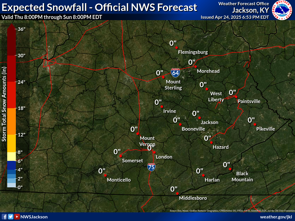
...Light Snow Late Tonight into Monday...
Light rain will transition over to light snow late tonight before
tapering off on Monday. A dusting to one half inch of snow
accumulation is expected over most of the area. Isolated higher
amounts of 1 to 2 inches cannot be ruled out in the higher
elevations near the Virginia border.
Temperatures falling back below freezing for most locations may
allow slick spots to develop overnight and persist into the
Monday morning commute. Those with travel plans on Monday morning
are encouraged to exercise caution and allow extra time to reach
their destination.
$$
GEERTSON
Warnings/Hazards
Decision Support - Outlooks
Current Weather Hazards
Hazards Criteria
Weather Story Graphic
Recent Storm Reports
Submit a Report
Forecasts
Decision Support - Forecast
Aviation Forecasts
Fire Weather Forecasts
Hourly Weather Forecast
Activity Planner
River Forecasts
Forecast Discussion
Current Conditions
Regional Radar
Decision Support - Current
Rivers and Lakes
Hourly Airport Weather
Local Radar
Satellite
Kentucky Mesonet
Past Weather
Local Climate Info
Temp/Precip Summary
How Much Rain Fell?
How Much Snow Fell?
Past Weather Events
Drought Information
Local Coop Observers
US Dept of Commerce
National Oceanic and Atmospheric Administration
National Weather Service
Jackson, KY
1329 Airport Road
Jackson, KY 41339
606-666-8000
Comments? Questions? Please Contact Us.

