|
956 FLUS43 KJKL 111320 HWOJKL Hazardous Weather Outlook National Weather Service Jackson KY 820 AM EST Thu Dec 11 2025 KYZ088-121330- Harlan- 820 AM EST Thu Dec 11 2025 ...WINTER WEATHER ADVISORY REMAINS IN EFFECT FROM 7 PM THIS EVENING TO 10 AM EST FRIDAY... This Hazardous Weather Outlook is for a portion of eastern Kentucky. .DAY ONE...Today and tonight. Light snow accumulation is expected tonight, especially over the higher elevations. .DAYS TWO THROUGH SEVEN...Friday through Wednesday. The next accumulating snowfall occurs Saturday night and early Sunday morning. .SPOTTER INFORMATION STATEMENT... Spotter activation is not expected at this time. $$ KYZ058-068-069-111>115-118-121330- Estill-Rockcastle-Jackson-Lee-Breathitt-Knott-Owsley-Perry-Letcher- 820 AM EST Thu Dec 11 2025 ...WINTER WEATHER ADVISORY REMAINS IN EFFECT FROM 7 PM THIS EVENING TO 10 AM EST FRIDAY... This Hazardous Weather Outlook is for a portion of eastern Kentucky. .DAY ONE...Today and tonight. Light to moderate snow accumuluations are expected tonight. .DAYS TWO THROUGH SEVEN...Friday through Wednesday. The next accumulating snowfall occurs Saturday night and early Sunday morning. .SPOTTER INFORMATION STATEMENT... Spotter activation is not expected at this time. $$ KYZ044-050>052-059-060-104-106>110-119-120-121330- Fleming-Montgomery-Bath-Rowan-Powell-Menifee-Elliott-Morgan-Johnson- Wolfe-Magoffin-Floyd-Martin-Pike- 820 AM EST Thu Dec 11 2025 ...WINTER WEATHER ADVISORY REMAINS IN EFFECT FROM 7 PM THIS EVENING TO 10 AM EST FRIDAY... This Hazardous Weather Outlook is for a portion of eastern Kentucky. .DAY ONE...Today and tonight. Moderate snow accumulations are expected tonight. .DAYS TWO THROUGH SEVEN...Friday through Wednesday. The next accumulating snowfall occurs Saturday night and early Sunday morning. .SPOTTER INFORMATION STATEMENT... Spotter activation is not expected at this time. $$ KYZ079-080-083>087-116-117-121330- Pulaski-Laurel-Wayne-McCreary-Whitley-Knox-Bell-Clay-Leslie- 820 AM EST Thu Dec 11 2025 This Hazardous Weather Outlook is for a portion of eastern Kentucky. .DAY ONE...Today and tonight. Minor snow accumulations are possible tonight. .DAYS TWO THROUGH SEVEN...Friday through Wednesday. The next accumulating snowfall occurs Saturday night and early Sunday morning. .SPOTTER INFORMATION STATEMENT... Spotter activation is not expected at this time. $$ GEERTSON/VORST |
Weather Story |
 |
|
| Today's Forecast Map | |
 |
|
| Tomorrow's Forecast Map | |
 |
|
| Day 3 Forecast Map | |
 |
 |
Current Watches |
Storm Trend Discussions |
Today's Storm Reports |
Yesterday's Storm Reports |
| SPC Day 1 Thunderstorm Outlook | SPC Day 1 Tornado Outlook | SPC Day 1 Severe Wind Outlook | SPC Day 1 Severe Hail Outlook |
 |
 |
 |
 |
| SPC Day 1 Thunderstorm Outlook Narrative | |||
| SPC Day 2 Thunderstorm Outlook | SPC Day 3 Thunderstorm Outlook | SPC Day 4-8 Thunderstorm Outlook |
 |
 |
 |
| SPC Day 2 Outlook Narrative | SPC Day 3 Outlook Narrative | SPC Day 4-8 Outlook Narrative |

| Day 1 Excessive Rainfall Outlook | Day 2 Excessive Rainfall Outlook | Day 3 Excessive Rainfall Outlook |
 |
 |
 |
| Day 1 Precipitation | Day 2 Precipitation | Day 3 Precipitation |
 |
 |
 |
| Day 4-5 Precipitation | Day 6-7 Precipitation | 7-Day Total Precipitation |
 |
 |
 |
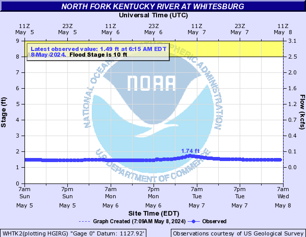
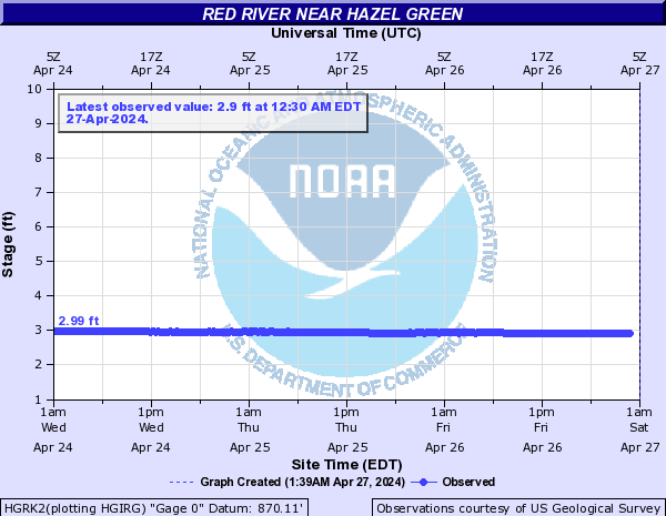
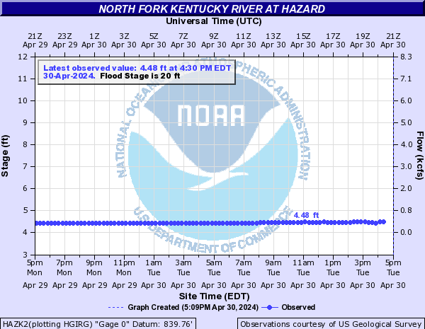
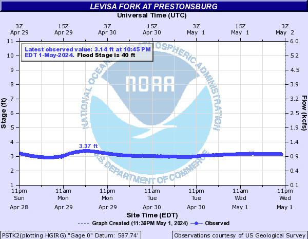
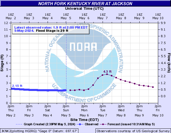
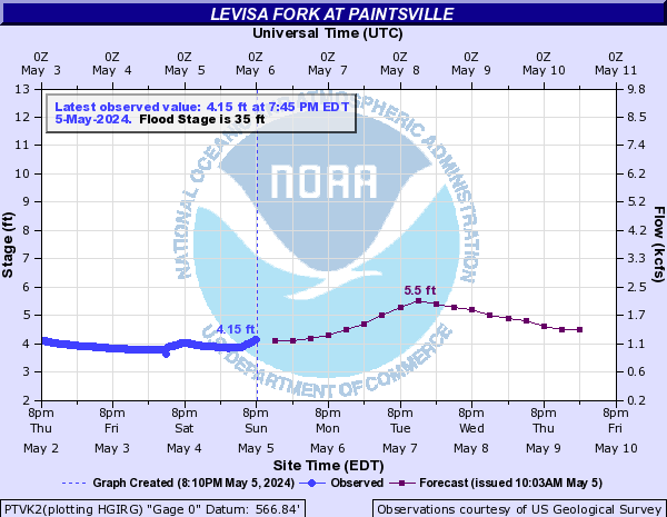
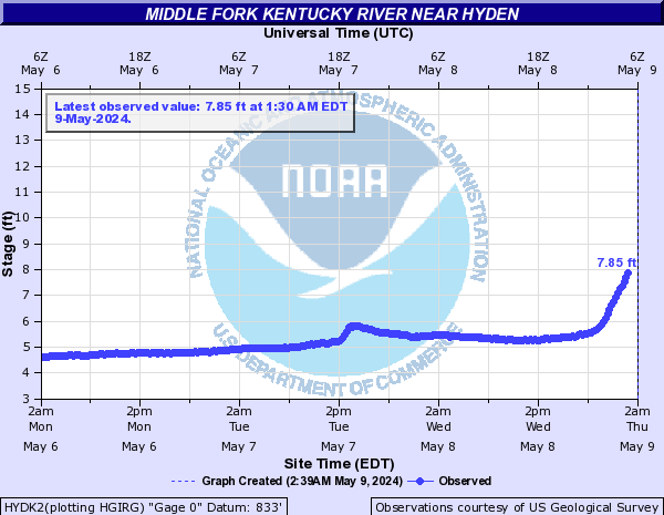
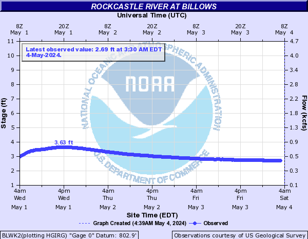
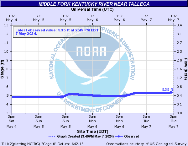
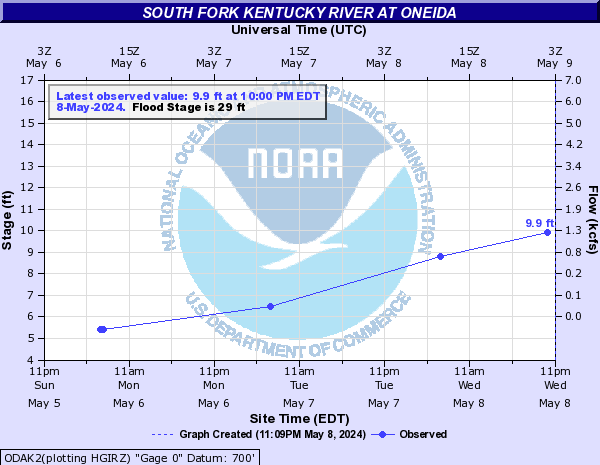
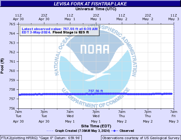
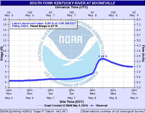
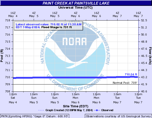
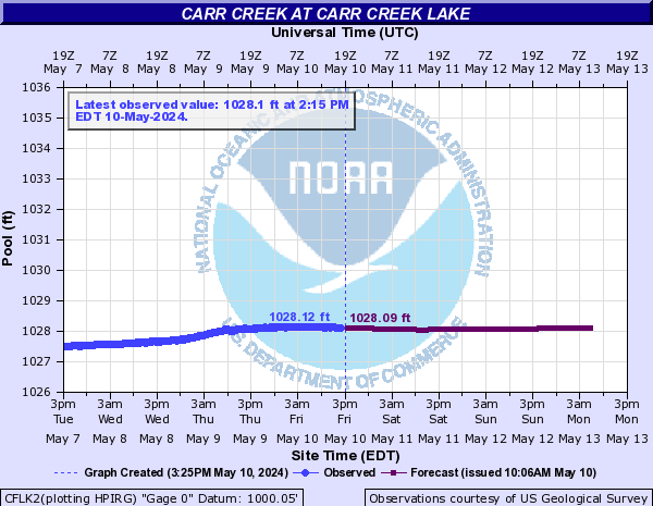
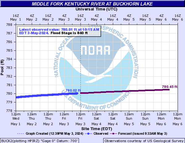
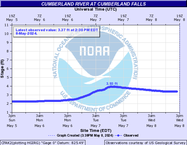
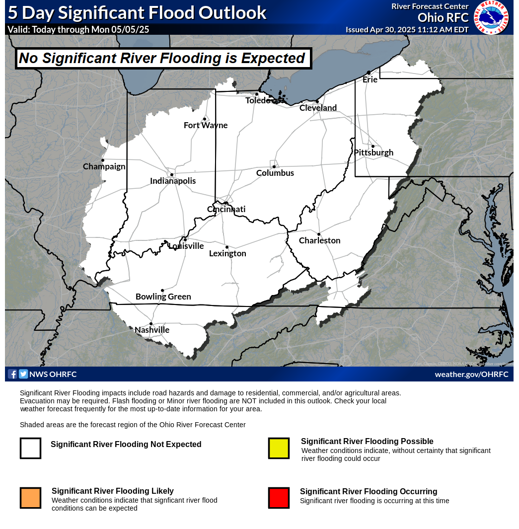
| Rivers/Lakes Quick Glance (click icons to enlarge or click here for more info and additonal locations) | Ohio River Basin Flood Outlook | ||||||||||||||||||||||||||||||||||||||||||||||||||||||||||||||||||||||||||||||
|
 |
||||||||||||||||||||||||||||||||||||||||||||||||||||||||||||||||||||||||||||||
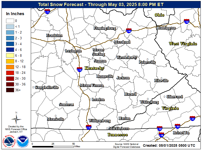
| Local Office Snow & Ice Forecasts | |
 |
 |
| Day 1 Snowfall Greater Than 4" | Day 2 Snowfall Greater Than 4" | Day 3 Snowfall Greater Than 4" |
 |
 |
 |
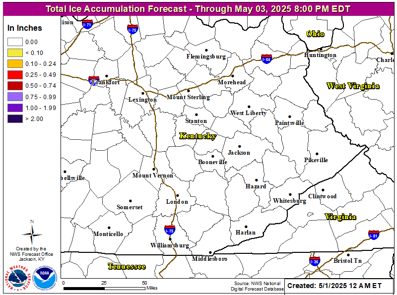
| Day 1 Freezing Rain Greater than 1/4" | Day 2 Freezing Rain Greater than 1/4" | Day 3 Freezing Rain Greater than 1/4" |
 |
 |
 |
WFAS Observed Fire Danger Rating |
WFAS Forecast Fire Danger Rating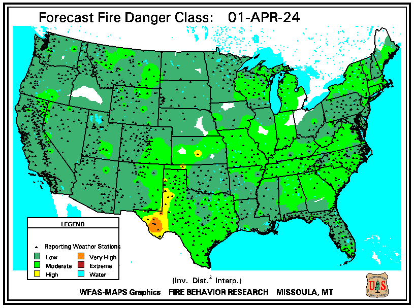 |
| SPC Fire Weather Day 1 Outlook | SPC Fire Weather Day 2 Outlook | SPC Fire Weather Day 3-8 Outlook |
 |
 |
 |
| Drought Monitor | Seasonal Drought Outlook | NICC Significant Fire Potential Outlook |
 |
 |
 |
 |