Sunrise Tuesday morning brought a beautiful blue sky, and a crisp Fall airmass. However, some folks had to start the day with patchy dense fog. This fog was brought on by a couple of factors, one of which is fairly common.
Radiation Fog
This type of fog forms at night under clear skies with calm winds when heat absorbed by the earth’s surface during the day is radiated into space. As the earth’s surface continues to cool, provided a deep enough layer of moist air is present near the ground, the humidity will reach 100% and fog will form. Radiation fog varies in depth from 3 feet to about 1,000 feet and usually remains stationary. This type of fog can reduce visibility to near zero at times and make driving very hazardous.
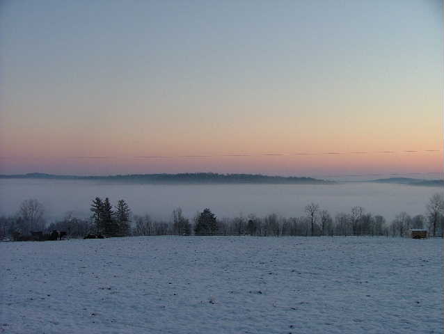
Valley fog is a type of radiation fog. When air along ridgetops and the upper slopes of mountains begins to cool after sunset, the air becomes dense and heavy and begins to drain down into the valley floors below. As the air in the valley floor continues to cool due to radiational cooling, the air becomes saturated and fog forms. Valley fog can be very dense at times. This type of fog tends to dissipate very quickly once the sun comes up and starts to evaporate the fog layer.
Example: Not Current
 |
|
Valley fog in Harrison County, Indiana. Scott Taylor Example: Not Current
|
The other type of fog we saw, steam fog, is more rare to our area, and takes a specific set of conditions.
Evaporation or Mixing Fog
This type of fog forms when sufficient water vapor is added to the air by evaporation and the moist air mixes with cooler, relatively drier air. The two common types are steam fog and frontal fog. Steam fog forms when cold air moves over warm water. When the cool air mixes with the warm moist air over the water, the moist air cools until its humidity reaches 100% and fog forms. This type of fog takes on the appearance of wisps of smoke rising off the surface of the water.
The other type of evaporation fog is known as frontal fog. This type of fog forms when warm raindrops evaporate into a cooler drier layer of air near the ground. Once enough rain has evaporated into the layer of cool surface, the humidity of this air reaches 100% and fog forms.
Below, you will find a satellite image of the fog on Tuesday morning, along with several webcam shots from around the area.

I-265 at Taylorsville Road

WBKO near the Bowling Green Regional Airport
.1609270745.jpg)
Near Cave City
.1609270811.jpg)
NWS Jackson, KY


 Weather Story
 Weather Map
 Local Radar