|
The National Weather Service relies heavily on amateur radio volunteers for reports. Even though NWS St. Louis no longer has active amateur radio operators in the office during severe weather, we have volunteers across the community who monitor the following repeaters and filter the reports to us in times of hazardous weather. The 145.330 repeater is used by St. Charles County as a |
Amateur radio is a vital part of the National Weather Service (NWS) SKYWARN system. The quick communication of severe weather reports and other weather information during severe weather outbreaks are an important part of the NWS warning process. Timely and accurate severe weather reports enable NWS meteorologists to issue better warnings. The NWS greatly appreciates the support we have received from the amateur radio community over the years and hope to continue the excellent relationship into the future. |
|
|
|
St. Louis Metropolitan Area : 145.330 Areas north of I-70: 145.190 In Central Missouri, the Missouri Highway Patrol Amateur Radio Club operates a repeater in Linn, MO, Osage County. This repeater has good coverage from Boone, Cole, Callaway, Osage to Gasconade County. Below is a map of the area we can cover and the frequencies used in each county. Click on the following link for an Excel spreadsheet that gives the repeater frequencies that correspond to the numbers in each County.
|
|
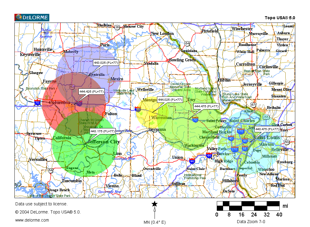
The Show-Me Intertie is a system of UHF repeaters that link the Jefferson City/Columbia, MO area to St. Louis. In early 2008, the Intertie was extended into Illinois. Below is a map of the MO Intertie system. As of September 2011, the Intertie was not working from High Hill, MO to the Columbia/Jefferson City area. |
|
|
|
Jefferson City: 443.175 (pl=77.0) Net control operators or individual spotters who can reach any of the Intertie repeaters should do so to relay your reports to the NWS. |
|
Gillespie: 444.250 (pl103.5) Net control opeators or individual spotters who can reach either of these repeaters should do so to relay your reports |
|
Whenever there is severe weather north of I-70 in MO, we will monitor this repeater. It has good coverage across Northeast Missouri. Net control operators or indivudual spotters in this area should try to reach the NWS through this repeater. |
|
The 145.330 repeater, operated by St. Charles County, and the 146.910 repeater (using a 141.3 tone) operated by the St. Louis County ARES group are the main repeaters where volunteers will be monitoring and passing the information on to NWS St. Louis. |
Back to WCM/Skywarn Page |


.jpg)
 Weather Story
 Weather Map
 Local Radar