On Tuesday, April 13, 2004, a severe wind event swept across parts of peninsular Florida in the wake of a mesoscale convective system (MCS) of thunderstorms. This is unusual because the winds, which gusted at times to about 70 mph in the vicinity of Lake Okeechobee, were not associated with the thunderstorms themselves, but were on the back side of the system. In fact, little or no rain was falling when the wind event was occurring. This is event is consistent
with a phenomenon called a 'wake low' pressure system. Wake lows are sometimes associated with MCSs as a result of subsidence warming that is maximized on the back edge of the trailing stratiform precipitation area (Johnson and Hamilton, 1988). Another excellent reference on this subject is a recent paper by Gaffin (1999).
Strong wind gusts were observed in the Fort Myers area around 08Z (4 AM EDT) with a gust to 50 knots reported at Regional Southwest Airport (KRSW) at 0817Z (417 AM) and 43 knots at Page Field in Fort Myers at 0800Z (4 AM). The strong winds were on the back edge of the light rain shield, well behind the thunderstorms of the MCS as it was moving across South Florida. A wind gust to 41 knots was recorded at the Naples Regional Airport (KAPF) at 0841Z (441 AM EDT) coinciding with rapidly falling pressures. Strong wind gusts, some reaching as high as 70 mph across Lake Okeechobee, moved steadily from west to east across peninsular Florida, reaching the communities of South Bay, Belle Glade, and Pahokee around 1000-1100Z (6-7 AM EDT). Several trailers were severely damaged in South Bay, rendering them uninhabitable. In Belle Glade, a shop window was blown out.
 Fig. 1 - Lake Okeechobee elevation in feet NGVD (courtesy Susan Sylvester, U.S. Army Corps of Engineers, Jacksonville District)
The wind event caused the water level of Lake Okeechobee to slope steeply from south to north (Fig.1 courtesy U.S. Army Corps of Engineers, Jacksonville District) in a "bathtub" type sloshing effect. The strong south winds over 2-3 hours before dawn on Tuesday blew the water from the south end of the lake (S310 near Clewiston) toward the north end of the lake (S193 near Okeechobee). At maximum, the difference between the lake elevation at S310 near Clewiston (just over 12 feet msl) and S193 near Okeechobee (around 17.6 feet msl) was about 5.6 feet near 5 AM EDT. You can easily see the sloshing that occurred at S193 with five separate peaks around midnight, 4 AM, 7 AM, 11 AM, and 3 PM EDT.
 Fig. 2 - Combined meteorological parameter trace at SFWMD data platform LZ40 on Lake Okeechobee for April 12-13, 2004. (Courtesy SFWMD Meteorologist Eric Swartz) (times are EST, add 1 hour for EDT)
This 'wake low' wind event is more typical of mesoscale convective systems (MCS) that occur across the Great Plains or the Southern states. Conservation of mass requires that where air goes up, someplace it must come down. Thunderstorms always mean air moving upwards, sometimes at great speeds and with turbulent results. On the back side of a line of thunderstorms, air is moving downward, usually much more slowly than the rising air in the thunderstorms. Sometimes, and probably in this case, downward moving air is accelerated by evaporative cooling of rainfall. Another characteristic of downward moving air is adiabatic warming, which can be seen in the temperature trace from South Florida Water Management District (SFWMD) data collection platform LZ40 on Lake Okeechobee just as the strong winds were beginning before 6 AM EDT (Fig. 2). All of this dynamic movement of air creates a mesoscale low pressure system called a 'wake low' and often results in very strong winds.
KAMX Miami WSR-88D Radar Reflectivity Image as strong winds occurred at Naples (0843Z or 443 AM EDT)
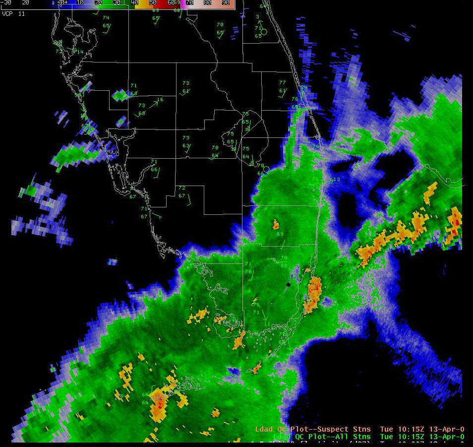
KAMX Miami WSR-88D Radar Reflectivity Image as strong winds occurred at Lake Okeechobee (1015Z or 615 AM EDT)
The event is not associated with the thunderstorms themselves, so therefore it cannot be called a derecho, even though it meets some of the criteria for duration and geographic extent. Wake lows have resulted in heat bursts in some cases in the midwestern states due to the adiabatic warming. In some cases, wake lows combined with strong inversions (temperatures rising with height) have resulted in gravity waves that have caused complicated severe wind events.
Some good papers on this subject include (visit the web site of the American Meteorological Society for online access):
Gaffin, D. M., 1999: Wake Low Severe Wind Events in the Mississippi River Valley: A Case Study of Two Contrasting Events. Wea. Fcstg., 14, 581-603.
Johnson, R. H., and P. J. Hamilton, 1988: The relationship of surface pressure features to the precipitation and airflow structure of an intense midlatitude squall line. Mon. Wea. Rev., 116, 1444–1472.
Stumpf, G. J., R. H. Johnson, and B. F. Smull, 1991: The wake low in a midlatitude mesoscale convective system having complex convective organization. Mon. Wea. Rev., 119, 134–158.
Pfost, WFO Miami, FL

