
Cold temperatures will continue across much of the eastern U.S. into today. Heavy lake effect snow continues into today east of Lakes Erie and Ontario. Two Pacific cold fronts will cross the Pacific Northwest early this week followed by another atmospheric river. Heavy rain and gusty winds are expected through midweek, with the potential for renewed urban and river flooding. Read More >
Several rounds of heavy rainfall over central Wisconsin over the past week has resulted in a considerable rise in Wisconsin River levels. The below graphic illustrates estimated rainfall across southern and central Wisconsin since the morning of Sunday, May 14th:

Much of west central to central Wisconsin received between 2 and 5 inches of precipitation. The part of the rainfall that fell into the Wisconsin River basin, over central Wisconsin, is moving down river.
These higher river levels are affecting the Wisconsin River in western Columbia County. The below hydrograph depicts the current level of the Wisconsin River at Portage:
\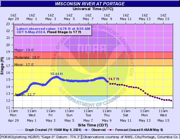
The river crested at 18.3 feet Sunday evening. The river stage is now slowly falling, but should remain above flood stage into early Wednesday morning.
Some impacts at 18.3 feet are:
- Floodwaters surround some seasonal homes along Old River Road in the Blackhawk Park area.
- Numerous roads in the Blackhawk Park area are affected by floodwaters.
- Old River Road is flooded and closed.
- West Lane Road in the Long Lake area is closed with about 4 feet of water over it in places.
Check out the latest Flood Statement regarding this flooding.
Here is the hydrograph for the Wisconsin River at the Wisconsin Dells, which is upriver from Portage:
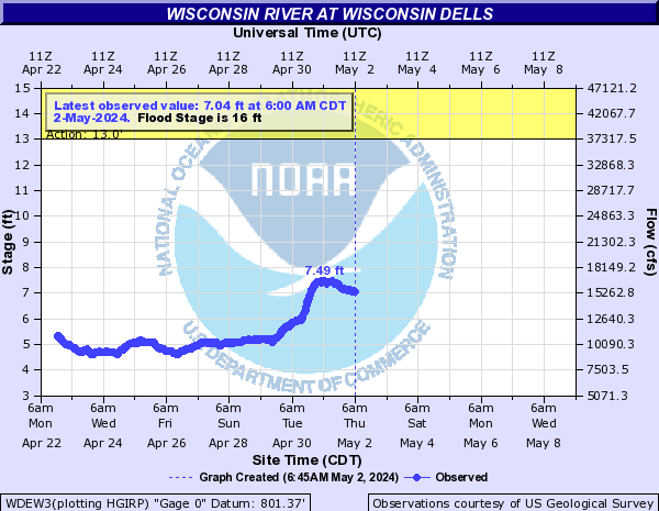
The Wisconsin River flooding affecting portions of Portage, and Columbia County, is expected to continue into early Wednesday morning. The river stage should then fall below flood stage.
If you live in one of these susceptible areas, please take the necessary precautions to safeguard yourself and your property.
Kavinsky/Wood
National Weather Service
Milwaukee/Sullivan, WI

