National Weather Service United States Department of Commerce

Snow in the Rockies; Showers and Thunderstorms Along the Gulf Coast; Potential Winter Storm for Northern Mid-Atlantic and Interior New England

A winter-like pattern will continue over much of the Lower 48 over the next few days, with snow stretching from the Rockies today into the Middle Mississippi Valley on Monday. Showers and thunderstorms will develop along the Gulf Coast and Southeast on Monday. As the storm moves northward late Monday into Tuesday, winter weather is possible from the Central Appalachians to Interior New England. Read More >

Click a location below for detailed forecast.

Last Map Update: Sun, Nov 30, 2025 at 11:18:21 pm EST


Weather impact Outlook for Monday through Wednesday.
Drier conditions return for a brief period of time for much of Monday before widespread rain moves back into the Tennessee valley and southern Appalachians for Monday night and Tuesday. Freezing rain is possible across the far northeast Tennessee mountains Monday night with a wintry mix possible for parts of southwest Virginia, northern Plateau, and far east Tennessee mountains late Tuesday. Drier conditions for Wednesday and Thursday.
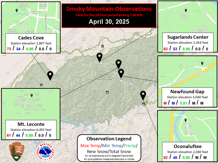
Each observation point is apart of our COOP program (Cooperative Observer Program). Each site has a 24 hour observation period that ends and begins at 8 am local time. Each site records temperature, precipitation, and snowfall data. More information about the COOP program can be found here www.nws.noaa.gov/om/coop/ Data began being collected at: Cades Cover on 01/01/1999 || Mount LeConte on 07/01/1987 || Newfound Gap on 01/01/1991 || Sugarlands Visitor Center on 12/01/1921

 Current Weather Observations...
Location Time
(EST)
Weather Vsby.
(SM)
Temp.
(ºF)
Dewpt.
(ºF)
Hum.
(%)
Wind
(mph)
Wind Chill / Heat Index
(ºF)
Pres.
(in)
Abingdon VA22:55Mostly Clear10332674NW 1024 [WC]30.30
Andrews-Murphy NC22:35Clear10373593CALM-30.28
Chattanooga TN22:53Mostly Cloudy10383072N 831 [WC]30.35
Crossville TN22:53Clear10292688NNE 721 [WC]30.34
Dalton GA22:55Overcast10393686NNW 1231 [WC]30.32
Knoxville TN (McGhee-Tyson)22:53Partly Cloudy10362975NNE 829 [WC]30.35
Middlesboro KY22:55Partly Cloudy10332776NNW 727 [WC]30.39
Monroe Cnty TN22:35Overcast103535100VRB 530 [WC]30.34
Morristown TN22:35Mostly Cloudyless than 1353393N 728 [WC]30.33
Oak Ridge TN22:53Clear10342775CALM-30.37
Tazewell Cnty VA22:55Overcast10292686NW 622 [WC]30.30
Tri-Cities TN22:53Partly Cloudy10363181WNW 3-30.33
Wise VA22:55Overcast10302686N 623 [WC]30.31
Greeneville, TN22:35Partly Cloudy10353286NNW 828 [WC]30.31


Local Weather History For November 30th...
Three tornadoes moved through SE TN in 2016 with 2 fatalities in Polk County.


Briefing Hydrology Past Weather Events Graphical Hazardous Weather Outlook for East Tennessee East Tennessee Observations
Decision Support Hydrology Past Weather Events GHWO Observations Gridded Forecast
Daily Climate for Middle Tennessee Local East Tennessee Climate Tornado Database Tropical Weather Information NOAA Weather Radio
IDSS Point Forecasts Daily Climate Local Climate Tornado Database Tropical Weather Radio
Daily Climate for Middle Tennessee Probabilistic Data for East Tennessee Virtual Tour of the NWS Morristown Office Skywarn Spotter Training for East Tennessee  
Being Prepared Estar Perparado Probabilistic Virtual Tour Spotter Training